Ellastone

Last updated

Ellastone
Staffordshire UK location map.svg
Red pog.svg
Ellastone
Location within Staffordshire
Population320 (2011) [1]
OS grid reference SK116429
District
Shire county
Region
Country England
Sovereign state United Kingdom
Post town Ashbourne
Postcode district DE6
Police Staffordshire
Fire Staffordshire
Ambulance West Midlands
List of places
UK
England
Staffordshire
52°59′00″N1°49′43″W / 52.98332°N 1.82867°W / 52.98332; -1.82867 Coordinates: 52°59′00″N1°49′43″W / 52.98332°N 1.82867°W / 52.98332; -1.82867

Ellastone is a village in the East Staffordshire borough of Staffordshire, in the West Midlands of England. It is on the Staffordshire side of the River Dove and is directly opposite the village of Norbury in Derbyshire. It is between Uttoxeter and Ashbourne.

Contents

Amenities

The village lies at the southern end of the Limestone Way trail and has a public house, church and school.

History

Ellastone is situated close to the River Dove, on the border between Derbyshire and Staffordshire. The village can be traced back to Anglo-Saxon times in documentation and it features in the Domesday Book, where it is listed as Edelachestone and Elachestone [2] . The Ellastone Parish Register (1907) records the variant spellings, to be found in early medieval manuscripts, as: "Edelachestone, Elachestone, Ethelaxton, Ethelaston, Adlaxton, Athelaxton, Adelachestone, Adalacheston, Edelestone."

One of the village cottages was apparently once owned by William Cecil, the influential politician and confidant of Elizabeth I.

The earliest part of the current parish church building of St. Peter's dates back to the 16th century, with the year 1586 displayed on the tower, but there has been a church on the site since at least 1163.

Ellastone was served by a railway station which was opened by the North Staffordshire Railway on the Ashbourne Line.

During World War II, the bridge over the River Dove was an important crossing point, guarded by two pill-boxes, one on each bank. Both are still visible today, however the box on the western side of the bridge is harder to spot but camouflage paint is still visible above the entrance.

The nearby bridge over the River Dove to Norbury in Derbyshire. Norbury Ellastone Dove Derbyshire.jpg
The nearby bridge over the River Dove to Norbury in Derbyshire.

Ellastone Old Hall, for some time the Bromley Arms public house, dates from the seventeenth century and is situated close to the current pub, the Duncombe Arms.

Ellastone parish

The wider parish of Ellastone originally had six townships: Ellastone; Calwich; Prestwood; Ramsor; Stanton and Wootton. Today Ellastone parish remains extensive, and includes the hamlets of Ramshorn, Wootton, and Prestwood. The Weaver Hills, about four miles north-west, lie just outside the parish.

Ellastone is situated in the now obsolete Hundred of Totmonslow. The Hundred had two major divisions and each had its own constable and Petty Sessions. The Petty Sessions for the South division were held at Ellastone [3]

Literary references

Ellastone features as 'Hayslope' in George Eliot's Adam Bede , published in 1859. It earned this recognition because the author's father spent the early part of his life in the village working as a carpenter...

"It was at Ellastone that Robert Evans, George Eliot's father, passed his early years and worked as a carpenter with his brother Samuel; and it was partly from reminiscences of her father's talk and from her uncle Samuel's wife's preaching experiences that the author constructed the very powerful and moving story of Adam Bede." [4]

There is an "Adam Bede Cottage" in the village, so named because it was the family home of the Evanses, the family of "George Eliot" - Mary Ann Evans. Her uncle lived there during her lifetime and it is said that she did visit.

The Methodist references in Adam Bede fit this locality well. Primitive Methodist was born nearby at Mow Cop and the hamlet of Ramshorn (known as Ramsor in Methodist documents) at the western end of the Parish of Ellastone was very significant in the early history of Primitive Methodism. [5] However the reality of the conversion of Hetty (a character in Adam Bede) is suspect in the light of early Primitive Methodist histories. [6]

Other points of historical interest

The ruined Calwich Abbey is also situated nearby. An abbey was first built on the site in 1148, however the latest hall, built in 1848, was demolished in 1935, leaving only the stable block which is visible today. The composer Handel was one of the abbey's guests on several occasions. As such it has been suggested that it may have inspired some of his most important pieces such as "Messiah" and the "Water Music".

Until demolition in 1935 there was a Wootton Hall built by Inigo Jones circa 1730, and formerly visited by the fleeing French political philosopher Rousseau. Arthur Mee notes that this visit was not entirely a happy one. [7] The jibes of the London wits, poking fun at Rousseau's hiding out in the hills, reveal that the place was then known as "Wootton under Weaver", a place were "where God came never" - meaning that it was known as one of the least Christian places in England. Wootton Hall has since been rebuilt at a smaller size as the residence of the Hon. Johnny Greenall of the brewing family.

Also within the parish is Wootton Lodge, a 17th-century house with deer park. This is an imposing property which has served many notable owners, but which is now owned by the Bamford family (JCB).

Notable people

See also

Related Research Articles

<span class="mw-page-title-main">Longnor, Staffordshire</span> Human settlement in England

Longnor is a village in the Staffordshire Peak District, England. The settlement dates from early times, the first recorded church building being in the Middle Ages. The village was named Longenalre in the Domesday Book. Located on a major crossroads, Longnor was a significant market town in the 18th century. It lies on the north bank of the River Manifold, on a limestone ridge between the Manifold and the River Dove.

<span class="mw-page-title-main">Ilam, Staffordshire</span> Human settlement in England

Ilam is a village in the Staffordshire Peak District of England, lying on the River Manifold. The population of the civil parish as taken at the 2011 census was 402.

<span class="mw-page-title-main">Flash, Staffordshire</span> Human settlement in England

Flash is a village in the Staffordshire Moorlands, England, and Peak District National Park. At 1,519 feet (463 m) above sea level, it is the highest village in the United Kingdom and was an early centre for Wesleyanism.

<span class="mw-page-title-main">Limestone Way</span> Long-distance footpath in England

The Limestone Way is a waymarked long-distance footpath in Derbyshire, England. It runs for 46 miles (74 km) through the White Peak of the Peak District National Park, from Castleton south to Rocester over the county boundary into Staffordshire. The trail is named for the limestone scenery along its route. It was devised by Brian Spencer of Matlock Rotary Club and developed and opened in 1986 by the West Derbyshire District Council. It originally ran to Matlock, but was extended to its current, longer route in 1992 to join up with the Staffordshire Way.

<span class="mw-page-title-main">Rocester</span> Human settlement in England

Rocester is a village and civil parish in the East Staffordshire district of Staffordshire, England. Its name is spelt Rowcestre in the Domesday Book. It is located on the Derbyshire border.

<span class="mw-page-title-main">Stanton, Staffordshire</span> Human settlement in England

Stanton is a small village situated at the eastern end of the Weaver Hills, Staffordshire, England.

<span class="mw-page-title-main">St Oswald's Church, Ashbourne</span> Church in United Kingdom

St Oswald's Church is a Church of England parish church located in Ashbourne, in the county of Derbyshire, England.

<span class="mw-page-title-main">Brinkworth, Wiltshire</span> Human settlement in England

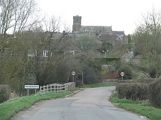
Brinkworth is a village and civil parish in northern Wiltshire, England. The village lies between Royal Wootton Bassett and Malmesbury, about 1 mile (1.6 km) north of the M4 motorway and 9 miles (14 km) west of Swindon.

<span class="mw-page-title-main">Brailsford</span> Human settlement in England

Brailsford is a small red-brick village and civil parish in Derbyshire on the A52 midway between Derby and Ashbourne. The parish also includes Brailsford Green. The civil parish population at the 2011 Census was 1,118. The village has a pub, a golf club, a post office and a school. There are many fine houses in the district including two 20th-century country houses: Brailsford Hall built in 1905 in Jacobean style, and Culland Hall.

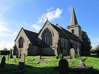
The tiny hamlet of Ramsor in North Staffordshire played a significant part in the origins of Primitive Methodism. Listed in the Domesday Book as Ramshorn, this ancient hamlet is a typical example of the depopulation of the countryside. Very little now remains of this village apart from a few farms and cottages. The Primitive Methodist Chapel is the only surviving public building.

<span class="mw-page-title-main">Weaver Hills</span>

The Weaver Hills are a small range of hills in north east Staffordshire, England.

<span class="mw-page-title-main">Norbury, Derbyshire</span> Human settlement in England

Norbury is a village in Derbyshire, England. It is located 3 miles (4.8 km) north of Rocester, on the B5033 road and the River Dove. The hamlet has links with George Eliot's family, the Evans. George Eliot's father, Robert Evans, was born in Roston Common and sang in the choir at Norbury church, and most of George Eliot's paternal ancestors are buried there.

<span class="mw-page-title-main">Parwich</span> Human settlement in England

Parwich is a village and parish in the Derbyshire Dales, 7 miles north of Ashbourne. In the 2011 census the population of the civil parish was 472.

<span class="mw-page-title-main">Wetton, Staffordshire</span> Human settlement in England

Wetton is a village in the Peak District National Park, North Staffordshire, at the top of the east side of the Manifold Valley. The population recorded in the 2001 Census was 157. At the time of the 2011 Census the population was recorded under Ilam. This article describes the location, some of the main features of the village, and a number of places of historical or general interest in or near the village. These include Long Low, Wetton, a prehistoric burial site unique to England.

<span class="mw-page-title-main">Wootton Lodge</span> Grade I listed gatehouse in the UK

Wootton Lodge is a privately owned 17th-century country house situated at Wootton near Ellastone, Staffordshire, England. It is a Grade I listed building.

<span class="mw-page-title-main">Wootton, Staffordshire</span> Human settlement in England

Wootton is a village and civil parish in Staffordshire, England. The village is situated approximately 20 miles (30 km) east from Stoke-on-Trent and 20 miles (30 km) northwest from Derby.

<span class="mw-page-title-main">Wootton, New Forest</span> Human settlement in England

Wootton is a hamlet in the civil parish of New Milton in Hampshire, England. It is in the south of the New Forest.

Ellastone is a civil parish in the district of East Staffordshire, Staffordshire, England. It contains 33 buildings that are recorded in the National Heritage List for England. Of these, three are listed at Grade II*, the middle grade, and the others are at Grade II, the lowest grade. Historically, the most important building in the parish was Calwich Abbey, a priory that has been demolished and replaced by a country house, which is listed together with associated strictures in the surrounding parkland. The parish contains the village of Ellastone and the surrounding countryside. Here, most of the listed buildings are houses, cottages, farmhouses and farm buildings. The other listed buildings include a church, bridges, and two mileposts.

<span class="mw-page-title-main">Clifton and Compton</span> Civil parish in Derbyshire, England

Clifton and Compton is a civil parish within the Derbyshire Dales district, in the county of Derbyshire, England. The parish, despite the name, only includes the villages of Clifton and Hangingbridge. In 2011 the parish had a population of 500. It is 124 miles (200 km) north west of London, 13 miles (21 km) north west of the county city of Derby, and 1+13 miles south west of the market town of Ashbourne. Clifton and Compton touches the parishes of Ashbourne, Edlaston and Wyaston, Mayfield, Offcote and Underwood, Osmaston, Okeover and Snelston. There are eight listed buildings in Clifton and Compton.

References

  1. "Civil Parish population 2011" . Retrieved 7 December 2015.
  2. Great Domesday Book folios 247r and 249r
  3. The English Counties Delineated, Volume 2, by Thomas Moule, 1837. Page 138
  4. The Living Age, Volume 303, 1919.
  5. Some of the significance of Ramsor in Primitive Methodism is collated on the Rewlach Methodist History site
  6. Various 19th-century Methodist histories are available on
  7. Arthur Mee, "The King's England; Staffordshire", (1937), p. 243
  8. Dictionary of National Biography, 1885-1900, Volume 52, Sheldon, Gilbert retrieved 19 August 2018
  9. Dictionary of National Biography, 1885-1900, Volume 50, Scattergood, Antony retrieved 19 August 2018