Springfield Township, or simply Springfield, is a township in Delaware County in the U.S. state of Pennsylvania. The population was 24,211 at the 2010 census. Springfield is a suburb of Philadelphia, located about 10 miles (16 km) west of the city.

Flourtown is a census-designated place (CDP) in Springfield Township, Montgomery County, Pennsylvania. Flourtown is adjacent to the neighborhoods of Erdenheim, Oreland, Whitemarsh, and Chestnut Hill. The population of Flourtown was 4,538 at the 2010 census. Its ZIP code is 19031.
Oreland is a United States census-designated place (CDP) in Springfield and Upper Dublin townships, just outside the Chestnut Hill and Mount Airy areas of Philadelphia. Oreland has a ZIP code of 19075, and the population was 5,678 at the 2010 census.

Springfield Township is a township in Montgomery County, Pennsylvania, United States. The population was 20,814 at the 2020 census. It includes the villages of Wyndmoor, Erdenheim, Flourtown, and Oreland. The communities of Lafayette Hill, Fort Washington, Laverock, North Hills, Miquon, and Glenside are also situated partly inside the Township.

Whitemarsh Township is a Home rule municipality in Montgomery County, Pennsylvania, United States. It retains its former classification of "Township" in its official name despite being a home rule municipality. The population was 17,349 at the 2010 census. Whitemarsh is adjacent to the neighborhood of Andorra in the Roxborough section of Philadelphia, and is bordered in Montgomery County by Springfield, Upper Dublin, Whitpain, and Plymouth townships, and by Conshohocken Borough. It is also bordered by the Schuylkill River, which separates it from Lower Merion Township. Communities within Whitemarsh Township include: Barren Hill; Lafayette Hill; part of Miquon, which straddles Whitemarsh and Springfield townships, Spring Mill; part of Plymouth Meeting ; and part of Fort Washington, some of which is in Whitemarsh, but which is chiefly in Upper Dublin Township.

Ardmore is an unincorporated community and census-designated place (CDP) spanning the border between Delaware and Montgomery counties in the U.S. state of Pennsylvania. The population was 12,455 at the 2010 census and had risen to 13,566 in the 2020 census.
Chestnut Hill is a neighborhood in the Northwest Philadelphia section of Philadelphia, Pennsylvania. It is known for the high incomes of its residents and high real estate values, as well as its private schools.

Roxborough is a neighborhood in the Northwest section of the city of Philadelphia, Pennsylvania. It is bordered to the southwest, along the Schuylkill River, by the neighborhood of Manayunk, along the northeast by the Wissahickon Creek section of Fairmount Park, and to the southeast by the neighborhood of East Falls. Beyond Roxborough to the northwest is Montgomery County. Roxborough's ZIP code is 19128. Most of Roxborough is in Philadelphia's 21st Ward.

Manayunk is a neighborhood in the section of Lower Northwest Philadelphia in the state of Pennsylvania. Located adjacent to the neighborhoods of Roxborough and Wissahickon and also on the banks of the Schuylkill River, Manayunk contains the first canal begun in the United States.
Holmesburg began as a Village within Lower Dublin Township, Pennsylvania. It is now a neighborhood in the Northeast section of Philadelphia, Pennsylvania. Holmesburg was named in Honor of Surveyor General of Pennsylvania Thomas Holme, who was a cartographer.

The Bustleton section of Northeast Philadelphia is located in the Far Northeast, north of Rhawnhurst and Fox Chase and south of Somerton; sitting between Roosevelt Boulevard to the east, the city boundary to the west, Red Lion Road to the north, and Pennypack Park to the south, it is centered at the intersection of Grant Avenue and Bustleton Avenue (PA-532) and is completely included in the 19115 postal ZIP code.
Carversville is an unincorporated community and geographically isolated area in Solebury Township, Bucks County, Pennsylvania, United States, approximately 45 miles north of Philadelphia. It was originally a Lenape gathering placed called Aquetong more than 300 years ago the area's land was granted to James Harrison and Joseph Pike by William Penn. The Paunacussing Creek also called Fleecydale runs through Carversville and meets the Delaware River at Lumberville.

Concordville is an unincorporated community in Concord Township, Delaware County, Pennsylvania, United States. It is located 20 miles west-southwest of Philadelphia, at the junction of U.S. Routes 1 and 322. This intersection can be traced back to two of the earliest roads in Pennsylvania, Baltimore Pike which became U.S. 1, and Concord Pike, which connected Pennsylvania with Delaware.
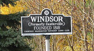
Windsor is a small historic unincorporated community located within Robbinsville Township in Mercer County, New Jersey, United States. The area is served as United States Postal Service ZIP Code 08561. There are approximately 50 homes in the area, and as of the 2010 United States Census, the population for ZIP Code Tabulation Area 08561 was 226. The community, covering 570 acres (230 ha), was added to the National Register of Historic Places in 1992.

Parkwood is a neighborhood located in the Far Northeast section of Philadelphia, Pennsylvania, United States. The neighborhood's boundaries include the Byberry East Industrial Park to the north and northwest, Poquessing Creek to the east, Knights Road to the southeast and Woodhaven Road to the southwest. The neighborhood was developed by Hyman Korman in the 1960-1962 as a planned residential community. The predominant housing type is the brick row house. The Parkwood Shopping Center is a local shopping destination, while the Philadelphia Mills mall is a regional shopping destination on Knights Road to the east of Parkwood's residential area.
Springfield Township School District is a public school district in Montgomery County, Pennsylvania, United States. The district serves parts of Springfield Township, including Oreland, Flourtown, Erdenheim, and Wyndmoor.
Carson College for Orphan Girls, also known as Carson Valley School, is a historic school complex and national historic district located in Flourtown, Springfield Township, Montgomery County, Pennsylvania. The buildings remain in active use by the same institution, now coeducational and named Carson Valley Children's Aid.

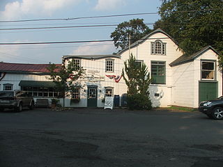
Springfield Mill, also known as the Piper-Streeper Mill, is a historic gristmill located along the Wissahickon Creek in Erdenheim, Springfield Township, Montgomery County, Pennsylvania. It is a building on the Bloomfield Farm tract, now part of Morris Arboretum.

Miquon is an unincorporated community in Montgomery County, Pennsylvania, United States. Located partly in Whitemarsh Township and partly in Springfield Township, it lies between the Roxborough section of Philadelphia and the Spring Mill section of Whitemarsh Township. Its borders are, roughly, Barren Hill Road, Ridge Pike, Manor Road, and the Schuylkill River. The sections of Miquon along the river and west of Harts Lane share the 19428 zip code with Conshohocken. The section east of Harts Lane shares the 19444 zip code with Lafayette Hill.

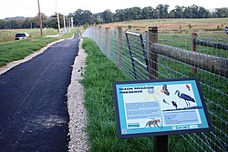
Erdenheim Farm is a 450-acre (1.82 km2) working farm in Springfield and Whitemarsh Townships, Montgomery County, Pennsylvania, United States. Located just outside the Chestnut Hill section of Philadelphia, it is bordered by the Morris Arboretum to the east, Whitemarsh Valley Country Club to the south, Carson Valley School to the north, and Corson's Quarry to the west. The Wissahickon Creek flows through the farm and Stenton Avenue crosses it. All but 23 acres of the land is now protected from development by conservation easements.