Hatboro, Pennsylvania

Last updated
Hatboro, Pennsylvania
Loller Academy, Hatboro PA 01.JPG
Hatboroseal.png
Hatboro Montgomery County.png
Location of Hatboro in Montgomery County, Pennsylvania.
USA Pennsylvania location map.svg
Red pog.svg
Hatboro
Location of Hatboro in Pennsylvania
Usa edcp location map.svg
Red pog.svg
Hatboro
Hatboro (the United States)
Coordinates: 40°10′27″N75°06′25″W / 40.17417°N 75.10694°W / 40.17417; -75.10694
CountryUnited States
State Pennsylvania
County Montgomery
Founded1715
Government
  MayorTim Schultz (D) [1]
Area
[2]
  Total1.42 sq mi (3.68 km2)
  Land1.42 sq mi (3.68 km2)
  Water0.00 sq mi (0.00 km2)
Elevation
223 ft (68 m)
Population
 (2020) [3]
  Total8,238
  Density5,793.25/sq mi (2,237.17/km2)
Time zone UTC-5 (EST)
  Summer (DST) UTC-4 (EDT)
ZIP Code
19040
Area codes 215, 267, and 445
FIPS code 42-33088 [4]
Website myhatboro.org

Hatboro (known locally as the Boro) is a borough in Montgomery County, Pennsylvania, United States. The population was 8,238 at the 2020 census. [5]

Contents

History

Battle of Crooked Billet Monument Battle of Crooked Billet Monument.jpg
Battle of Crooked Billet Monument

The town of Hatboro is located on land purchased from William Penn by the family of Nicholas More around 1705. The first land titles in town were issued in 1711. Original construction by early residents of the town occurred between 1715 and 1719. Early settlement pre-dating the Hatboro name occurred in the Crooked Billet area east of York Road, between Moreland Avenue and Byberry Road.

Early resident John Dawson entertained guests at the Crooked Billet Inn as well as manufacturing a line of hats. When the post office opened in 1809 the town was officially called Hatborough. U.S. Postmaster General John Wanamaker officially changed the name of the town in 1889 to Hatboro.

The Union Library Company of Hatboro, the third library company to be founded in Pennsylvania, was formed in 1755. This building still stands on its original site today and still serves as a library. George Washington and his troops passed through the town numerous times during 1777 in pursuit of British Troops. The Battle of Crooked Billet was fought in 1778.

The year 1811 saw the construction of the Loller Academy, the first bank was built in 1873, and railroad service connected to Hatboro in 1874. [6]

The Loller Academy, Roberts and Mander Stove Company Buildings, and Union Library Company are listed on the National Register of Historic Places. [7]

Geography

Hatboro is located at 40°10′39″N75°6′16″W / 40.17750°N 75.10444°W / 40.17750; -75.10444 (40.177635, −75.104424). [8] According to the U.S. Census Bureau, the borough has a total area of 1.4 square miles (3.6 km2), all land.

The Borough of Hatboro is a small municipality that is surrounded by Upper Moreland Township in Montgomery County to the west, south, and east; and Warminster Township in Bucks County to the north. The Pennypack Creek runs through the center of town under Pennsylvania Route 263 (York Road) and through the municipality.

Climate

The climate in this area is characterized by hot, humid summers and generally mild to cool winters. According to the Köppen Climate Classification system, Hatboro has a humid subtropical climate, abbreviated "Cfa" on climate maps.

Hatboro is Plant Hardiness Zone 7a (0°F to 5°F) for both the 2012 and 2023 Plant Hardiness Maps, with a +3F change from 2012 to 2023. [9]

Climate data for Hatboro, Pennsylvania
MonthJanFebMarAprMayJunJulAugSepOctNovDecYear
Mean daily maximum °F (°C)39
(4)
43
(6)
52
(11)
63
(17)
74
(23)
82
(28)
87
(31)
85
(29)
77
(25)
66
(19)
55
(13)
44
(7)
64
(18)
Mean daily minimum °F (°C)24
(−4)
25
(−4)
33
(1)
42
(6)
52
(11)
61
(16)
66
(19)
65
(18)
57
(14)
45
(7)
37
(3)
29
(−2)
45
(7)
Average precipitation inches (mm)3.9
(99)
3.0
(76)
4.2
(110)
3.9
(99)
4.8
(120)
3.6
(91)
4.7
(120)
4.3
(110)
4.7
(120)
3.4
(86)
3.7
(94)
3.8
(97)
48
(1,222)
Source: The Weather Channel [10]

Demographics

Historical population
CensusPop.Note
1880 586
1890 78133.3%
1900 8235.4%
1910 96317.0%
1920 1,10214.4%
1930 2,651140.6%
1940 2,605−1.7%
1950 4,78883.8%
1960 7,31552.8%
1970 8,88021.4%
1980 7,579−14.7%
1990 7,382−2.6%
2000 7,3930.1%
2010 7,360−0.4%
2020 8,23811.9%
2021 (est.)8,239 [11] 0.0%
Sources: [12]
2020 Census [5] [3]
York Road northbound in Downtown Hatboro PA 263 NB past Byberry Road Hatboro.jpg
York Road northbound in Downtown Hatboro

2010 census

As of the census of 2010, the borough was 92.4% White, 2.7% Black or African American, 0.3% Native American, 1.6% Asian, and 1.6% were two or more races. 4.3% of the population were of Hispanic or Latino ancestry [13]

2000 census

As of the census of 2000, there were 7,393 people, 3,041 households, and 1,955 families residing in the borough. The population density was 5,217.5 inhabitants per square mile (2,014.5/km2). There were 3,121 housing units at an average density of 2,202.6 per square mile (850.4/km2). The racial makeup of the borough was 95.74% White, 1.95% African American, 0.14% Native American, 1.06% Asian, 0.58% from other races, and 0.54% from two or more races. Hispanic or Latino of any race were 1.45% of the population.

There were 3,041 households, out of which 30.7% had children under the age of 18 living with them, 49.3% were married couples living together, 10.7% had a female householder with no husband present, and 35.7% were non-families. 30.8% of all households were made up of individuals, and 13.9% had someone living alone who was 65 years of age or older. The average household size was 2.43 and the average family size was 3.07.

In the borough the population was spread out, with 24.0% under the age of 18, 6.6% from 18 to 24, 33.0% from 25 to 44, 21.2% from 45 to 64, and 15.1% who were 65 years of age or older. The median age was 38 years. For every 100 females there were 92.3 males. For every 100 females age 18 and over, there were 88.4 males.

The median income for a household in the borough was $44,901, and the median income for a family was $58,063. Males had a median income of $37,291 versus $30,934 for females. The per capita income for the borough was $21,911. About 1.8% of families and 3.3% of the population were below the poverty line, including 3.4% of those under age 18 and 7.5% of those age 65 or over.

Parks and recreation

Hatboro Memorial Park Hatboro Memorial Park in Hatboro PA.jpg
Hatboro Memorial Park

Public parks serving the borough of Hatboro include Hatboro Memorial Park, Eaton Park, Tanner Park, Miller Meadow, Blair Mill Park (home of the Hatboro Little League baseball fields), which is owned by Upper Moreland Township but is in Horsham Township, Celano Park, and Pennypack Park (on the grounds of the now-closed Pennypack Elementary School). [14]

The Hatboro Memorial Pool is located adjacent to Hatboro Memorial Park and is open during the summer from Memorial Day weekend to Labor Day weekend. The pool offers a water slide, a baby pool, and a dew drop. The Hatboro Memorial Pool offers day passes and season memberships, with lower rates for borough residents, and has a swim team, the Hatboro Storm. [15] [16]

Politics and government

Hatboro borough hall Hatboro, Pennsylvania (4071885814).jpg
Hatboro borough hall
Presidential elections results [17]
Year Republican Democratic
2020 40.0% 1,88358.7%2,763
2016 41.2% 1,67754.1%2,206
2012 42.1% 1,55156.1%2,065
2008 39.8% 1,45258.7%2,142
2004 45.8% 1,63253.5%1,906
2000 46.6% 1,38349.2%1,461

Hatboro has a city manager form of government with a mayor and a seven-member borough council.

The Borough Manager is Diane Hegele.

The borough is part of the:

The borough maintains the Hatboro Police Department, which provides police services to Hatboro. The Hatboro Police Department is composed of the Chief of Police, five Sergeants, eight Patrol Officers, three Police Operations Clerks, a Secretary, and five school crossing guards. [27] Fire protection in Hatboro is provided by the Enterprise Fire Company of Hatboro, a volunteer fire company. [28] Emergency Medical Services in Hatboro and surrounding areas is provided by the Second Alarmers Rescue Squad, which maintains a station in the borough. [29] [30]

Education

Hatboro is served by the Hatboro-Horsham School District, along with Horsham Township. One of the district's elementary schools, Crooked Billet Elementary School, is located in the borough. The remainder of the schools, including Keith Valley Middle School and Hatboro-Horsham High School, are in Horsham Township. [31] [32]

Infrastructure

Transportation

PA 263 just north of PA 332 in Hatboro 2022-10-31 14 30 58 View north along Pennsylvania State Route 263 (York Road) just north of Pennsylvania State Route 332 (Montgomery Avenue) in Hatboro, Montgomery County, Pennsylvania.jpg
PA 263 just north of PA 332 in Hatboro

As of 2017 there were 21.91 miles (35.26 km) of public roads in Hatboro, of which 4.47 miles (7.19 km) were maintained by the Pennsylvania Department of Transportation (PennDOT) and 17.44 miles (28.07 km) were maintained by the borough. [33]

The main north–south road in Hatboro is Pennsylvania Route 263 (York Road), which serves as the town's main street. Pennsylvania Route 332 begins at PA 263 in Hatboro and heads east on Montgomery Avenue and northeast on Jacksonville Road. The main east–west street in Hatboro is Moreland Avenue. Other important roads in Hatboro include County Line Road (which runs along the northern border with Warminster Township in Bucks County) (SR 2038), Warminster Road (which runs along the eastern border with Upper Moreland Township) (SR 2040), Byberry Road (formerly PA 763 and now SR 2009, and Horsham Road. The Willow Grove interchange of the Pennsylvania Turnpike (Interstate 276) is nearby in Upper Moreland Township. [31]

A SEPTA Regional Rail train on the Warminster Line stops at the Hatboro station Hatboro PA SEPTA station December 2015.jpg
A SEPTA Regional Rail train on the Warminster Line stops at the Hatboro station

SEPTA provides Regional Rail service to the borough at the Hatboro station along the Warminster Line which runs between Warminster and Center City Philadelphia. [34] SEPTA City Bus Route 22 serves Hatboro along York Road, running between Warminster and the Olney Transportation Center in North Philadelphia. [35]

Parking in the downtown area of Hatboro is regulated by on-street parking meters and public off-street parking lots using multi-space parking meters. The borough also maintains a paid parking lot for commuters near the Hatboro station along with on-street parking meters along Jacksonville Road near the train station. [36] [37]

Utilities

Electricity and natural gas in Hatboro is provided by PECO Energy Company, a subsidiary of Exelon. [38] [39] [40] Water in Hatboro is provided by Aqua Pennsylvania, a subsidiary of Aqua America. [41] The Upper Moreland-Hatboro Joint Sewer Authority provides sewage service to Hatboro along with neighboring Upper Moreland Township. [42] The Hatboro Borough Public Works Department provides trash and recycling collection to the borough. [43] Cable, telephone, and internet service to the area is provided by Xfinity and Verizon. Hatboro is served by area codes 215, 267, and 445. [44]

Notable people

Related Research Articles

<span class="mw-page-title-main">Montgomery County, Pennsylvania</span> County in Pennsylvania, United States

Montgomery County, colloquially referred to as Montco, is a county in the Commonwealth of Pennsylvania. As of the 2020 census, the population of the county was 856,553, making it the third-most populous county in Pennsylvania after Philadelphia and Allegheny counties.

<span class="mw-page-title-main">Warminster Township, Pennsylvania</span> Township in Pennsylvania, United States

Warminster Township, also referred to as Warminster, is located in Bucks County, Pennsylvania, United States. It was formally established in 1711. The township is 13.7 miles north of Philadelphia and had a population of 33,603 according to the 2020 U.S. census.

<span class="mw-page-title-main">Warminster Heights, Pennsylvania</span> Census-designated place in Pennsylvania, United States

Warminster Heights is a census-designated place and part of Warminster Township in Bucks County, Pennsylvania, United States. It is located near the eastern border of Hatboro in Montgomery County. The population was 4,124 at the 2010 census.

<span class="mw-page-title-main">Abington Township, Montgomery County, Pennsylvania</span> Township in Pennsylvania, United States

Abington Township is a township in Montgomery County, Pennsylvania, United States. It is adjacent to Philadelphia's northern fringe. The population was 58,502 as of the 2020 census, making it the second most populous township in Montgomery County after Lower Merion Township. The population density is 3603.3 per square mile (1,377/km2), making it the second most densely populated township in Montgomery County after Cheltenham Township.

<span class="mw-page-title-main">Hatfield, Pennsylvania</span> Borough in Pennsylvania, United States

Hatfield is a borough in Montgomery County, Pennsylvania, United States. The population was 3,290 at the time of the 2010 census. It is part of the North Penn Valley region that is centered around the borough of Lansdale. The borough is surrounded by Hatfield Township.

<span class="mw-page-title-main">Horsham, Pennsylvania</span> Census-designated place in Pennsylvania, United States

Horsham is a census-designated place in Horsham Township, Montgomery County, Pennsylvania, United States. The population was 15,193 at the 2020 census. It is home to the Biddle Air National Guard Base at the former site of Naval Air Station Joint Reserve Base Willow Grove.

<span class="mw-page-title-main">Horsham Township, Pennsylvania</span> Home rule municipality in Pennsylvania, United States

Horsham Township is a home rule municipality in Montgomery County, Pennsylvania. It is located ten miles north of Center City Philadelphia. The township, incorporated in 1717, is one of the oldest original municipalities in Montgomery County. Although it retains the word "Township" in its official name, it has been governed by a Home Rule Charter since 1975 and is therefore not subject to the Pennsylvania Township Code. The population was 26,564 at the time of the 2020 census.

<span class="mw-page-title-main">North Wales, Pennsylvania</span> Borough in Pennsylvania, United States

North Wales is a borough in Montgomery County, Pennsylvania. It is a suburb of Philadelphia and is one of the three historic population centers that make up the North Penn Valley, which is centered on the borough of Lansdale. It is approximately 27 miles (43 km) north of Center City Philadelphia. The population was 3,426 as of the 2020 census.

<span class="mw-page-title-main">Souderton, Pennsylvania</span> Borough of Pennsylvania, US

Souderton is a borough in Montgomery County, Pennsylvania, United States. The population was 7,246 in 2022 according to the Census Bureau.

<span class="mw-page-title-main">Upper Moreland Township, Pennsylvania</span> Township in Pennsylvania, United States

Upper Moreland Township is a township in Montgomery County, Pennsylvania. The population was 24,015 at the 2010 census. Upper Moreland Township is primarily a residential community with distinctive neighborhoods that are complemented by several thriving business, industrial, and commercial districts.

<span class="mw-page-title-main">Willow Grove, Pennsylvania</span> Census-designated place in Pennsylvania, United States

Willow Grove is a census-designated place (CDP) in Montgomery County, Pennsylvania, United States. A community in Philadelphia's northern suburbs, the population was 13,730 at the 2020 census. It is located in Upper Dublin Township, Abington Township and Upper Moreland Township. Willow Grove was once known for Willow Grove Park, an amusement park that was open from 1896 to 1976, now the site of Willow Grove Park Mall. Willow Grove is considered an edge city of Philadelphia, with large amounts of retail and office space.

<span class="mw-page-title-main">Hatboro station</span>

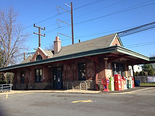
Hatboro station is a rail station on SEPTA Regional Rail's Warminster Line, formerly the Reading Railroad's New Hope Branch, in Hatboro, Pennsylvania and once terminus for electrified MUs. Electrification was extended to Warminster in 1974. Current trains stopping at Hatboro station are the SEPTA Silverliner IV and the SEPTA Silverliner V. The station is located at the intersection of Byberry Road and Penn Street. The station features a passing siding for handling multiple trains as well as a 100-space parking lot. The current brick construction station stands at 20' x 55' and was built in 1935. An original wood construction freight station was completed in 1871 but no longer stands at the site.

<span class="mw-page-title-main">Hatboro-Horsham Senior High School</span> Public school in Horsham, Pennsylvania, United States

Hatboro-Horsham Senior High School is a comprehensive public high school, serving grades 9 -12, located in Horsham, Pennsylvania, about 17 miles outside of Philadelphia. Hatboro-Horsham Senior High School, a successor of the Loller Academy, originally opened in 1950 on Old York Road in Hatboro following the jointure of the Hatboro-Horsham School District. In 1964, the High School relocated to Meetinghouse Road, originally built as Keith Valley Junior High in 1957. The Meetinghouse campus currently houses Keith Valley Middle School. In 1991, the school was moved into a new building, its current location, on Pennsylvania Route 463. It is the only high school in the Hatboro-Horsham School District which includes Horsham Township, Montgomery County, Pennsylvania and Hatboro, Pennsylvania. Its main feeder school is Keith Valley Middle School. Hatboro-Horsham is a member of the Suburban One League Continental Conference and offers a variety of sports programs. Extracurricular activities are also offered in the form of performing arts, school publications, and clubs.

The Hatboro-Horsham School District is located in Montgomery County in the U.S. state of Pennsylvania. It is a suburban Philadelphia school district of approximately 4800 students. The district operates four elementary schools (K-5), one Middle School (6-8) and one high school (9-12) in Horsham Township and the borough of Hatboro. In total, the district operates 6 schools.

<span class="mw-page-title-main">Pennsylvania Route 263</span> North–south state highway located in southeast Pennsylvania

Pennsylvania Route 263 (PA 263) is a north–south state highway located in southeast Pennsylvania. The southern terminus of the route is at PA 611 in Willow Grove, Montgomery County. The northern terminus is at the Centre Bridge–Stockton Bridge over the Delaware River in Centre Bridge, Bucks County, where the road continues into Stockton, New Jersey, as Bridge Street to an intersection with Route 29. PA 263 follows the routing of Old York Road, a historic road that connected Philadelphia to New York City, and carries the name York Road from the southern terminus to Lahaska and Upper York Road north of there. From Willow Grove to Buckingham, PA 263 runs mostly through suburban areas as a four-lane road, passing through Hatboro, Warminster, and Jamison. The route forms a concurrency with U.S. Route 202 (US 202) in Buckingham and narrows to a two-lane road, splitting with that route in Lahaska. From here, the route continues through rural areas to Centre Bridge.

<span class="mw-page-title-main">Upper Moreland School District</span> School district in Pennsylvania, United States

Upper Moreland School District is located in Upper Moreland Township, Montgomery County in the northern suburbs of Philadelphia, Pennsylvania. The Township has a general population of 25,000 residents who are served by the post offices of Willow Grove, Hatboro, and Huntingdon Valley, although due to postal and municipal boundaries, many students served by the Hatboro post office attend Hatboro-Horsham School District, while others served by the Huntingdon Valley post office attend Lower Moreland schools.

<span class="mw-page-title-main">Pennsylvania Route 332</span> State highway in Pennsylvania, US

Pennsylvania Route 332 (PA 332) is a state highway in the U.S. state of Pennsylvania. The route runs 17.5 miles (28.2 km) from PA 263 in Hatboro, Montgomery County, east to PA 32 in Yardley, Bucks County. PA 332 runs through suburban areas to the north of Philadelphia, serving Warminster, Ivyland, Richboro, and Newtown. The route is two lanes wide most of its length, with the bypass around Newtown a four-lane divided highway. PA 332 intersects PA 132 in Warminster, PA 232 in Richboro, PA 413 and PA 532 in Newtown, and Interstate 295 (I-295) in Lower Makefield Township.

<span class="mw-page-title-main">Pennsylvania House of Representatives, District 152</span> American legislative district

The 152nd Pennsylvania House of Representatives District is located in Montgomery County and Philadelphia and includes the following areas:

<span class="mw-page-title-main">Power Line Trail</span> Multi-use trail in Horsham Township, Pennsylvania

The Power Line Trail is a multi-use trail located in Horsham Township, Montgomery County, Pennsylvania. It follows a PECO Energy right-of-way through the township.

<span class="mw-page-title-main">Fulmor, Pennsylvania</span> Unincorporated community in Pennsylvania, United States

Fulmor is an unincorporated community in Upper Moreland Township in Montgomery County, Pennsylvania, United States. Fulmor is located at the intersection of Byberry Road and Warminster Road east of Hatboro. Fulmor uses the Hatboro ZIP code of 19040. The Fulmor Heights residential neighborhood is 59.74 acres and is governed by a housing cooperative known as the Fulmor Heights Home Ownership Association. The neighborhood contains a deli, beauty salon, social club, and gathering hall.

References

  1. "Home". Borough of Hatboro. Retrieved February 13, 2024.
  2. "ArcGIS REST Services Directory". United States Census Bureau. Retrieved October 12, 2022.
  3. 1 2 "Census Population API". United States Census Bureau. Retrieved Oct 12, 2022.
  4. "U.S. Census website". United States Census Bureau . Retrieved January 31, 2008.
  5. 1 2 "Explore Census Data". United States Census Bureau . Retrieved July 5, 2022.
  6. Hatboro. Arcadia Publishing. 2000. ISBN   0-7385-0342-8.
  7. "National Register Information System". National Register of Historic Places . National Park Service. July 9, 2010.
  8. "US Gazetteer files: 2010, 2000, and 1990". United States Census Bureau. February 12, 2011. Retrieved April 23, 2011.
  9. "2023 USDA Plant Hardiness Zone Map" . Retrieved February 13, 2024.
  10. "Climate Statistics for Hatboro, Pennsylvania" . Retrieved January 29, 2017.
  11. "City and Town Population Totals: 2020-2021". United States Census Bureau. July 5, 2022. Retrieved July 5, 2022.
  12. "Census of Population and Housing". U.S. Census Bureau. Retrieved December 11, 2013.
  13. U.S. Census Bureau. "Hatboro, Pennsylvania 2010 Decennial Census Information". ProximityOne. Archived from the original on August 1, 2022. Retrieved August 1, 2022.
  14. "Public Parks". Borough of Hatboro. Retrieved February 13, 2024.
  15. "Memorial Pool". Borough of Hatboro. Retrieved February 13, 2024.
  16. "Hatboro Memorial Pool Summer 2016" (PDF). Hatboro Memorial Pool. Retrieved February 13, 2024.
  17. "Montgomery County Election Results". Montgomery County, Pennsylvania. Retrieved January 16, 2017.
  18. "Tim Schultz - Borough of Hatboro". Borough of Hatboro. Retrieved February 13, 2024.
  19. "George Bollendorf - Borough of Hatboro". Borough of Hatboro. Retrieved February 13, 2024.
  20. "Dave Stockton - Borough of Hatboro". Borough of Hatboro. Retrieved February 13, 2024.
  21. "Nicole McMenamin - Borough of Hatboro". Borough of Hatboro. Retrieved February 13, 2024.
  22. "Nicole Shay - Borough of Hatboro". Borough of Hatboro. Retrieved August 30, 2023.
  23. "Nicole Shay". Hatboro Democratic Committee. Retrieved August 30, 2023.
  24. "Nicole Reichner - Borough of Hatboro". Borough of Hatboro. Retrieved February 13, 2024.
  25. "Alex Myers - Borough of Hatboro". Borough of Hatboro. Retrieved February 13, 2024.
  26. "Amanda Jacobus - Borough of Hatboro". Borough of Hatboro. Retrieved February 13, 2024.
  27. "Hatboro Police Department". Borough of Hatboro. Retrieved February 13, 2024.
  28. "Home". Enterprise Fire Company of Hatboro. Retrieved February 13, 2024.
  29. "About Us". Second Alarmers Association and Rescue Squad. Retrieved February 13, 2024.
  30. "Stations". Second Alarmers Association and Rescue Squad. Retrieved February 13, 2024.
  31. 1 2 Montgomery County, Pennsylvania (Map) (18th ed.). 1"=2000'. ADC Map. 2006. ISBN   0-87530-775-2.
  32. "Hatboro-Horsham School District". Borough of Hatboro. Retrieved May 9, 2016.
  33. "Hatboro Borough map" (PDF). PennDOT. Retrieved March 10, 2023.
  34. "Warminster Line schedule" (PDF). SEPTA. Retrieved August 24, 2014.
  35. "Route 22 bus map" (PDF). SEPTA. Retrieved October 13, 2010.
  36. "Chapter 15: Motor Vehicles and Traffic - Part 5: On-Street Metered Parking". Borough of Hatboro. Retrieved August 22, 2018.
  37. "Chapter 15: Motor Vehicles and Traffic - Part 6: Off-Street Parking". Borough of Hatboro. Retrieved August 22, 2018.
  38. "PECO: Company Information". PECO Energy Company. Retrieved January 29, 2017.
  39. "Electric Service Tariff" (PDF). PECO Energy Company. July 17, 2017. p. 4. Retrieved October 10, 2017.
  40. "Gas Service Tariff" (PDF). PECO Energy Company. August 30, 2017. p. 2. Retrieved October 10, 2017.
  41. "Rates and Rules Governing the Distribution of Water" (PDF). Aqua Pennsylvania. March 11, 2013. p. 3. Retrieved October 11, 2017.
  42. "About Us". Upper Moreland-Hatboro Joint Sewer Authority. Retrieved January 29, 2017.
  43. "Trash Collection". Borough of Hatboro. Retrieved April 5, 2021.
  44. Area Code 215 and 267 Map (PDF) (Map). Pennsylvania Public Utility Commission . Retrieved June 22, 2011.
  45. Terruso, Julia (October 14, 2020). "Jill Biden's Philly 'grit'". The Philadelphia Inquirer . Archived from the original on November 5, 2020. Retrieved November 7, 2020.
  46. "HATBORO-HORSHAM HIGH SCHOOL INDUCTS SEVEN NEW MEMBERS TO HALL OF FAME ON APRIL 29". Hatboro-Horsham School District. Retrieved March 17, 2013.
  47. Bonkowski, Jerry (December 27, 2017). "Greg Erwin ready for new challenge as Cup crew chief with Wood Brothers and Paul Menard". NBC Sports. Retrieved February 21, 2018.
  48. "HD-152, Nancy Guenst". Turn PA Blue. Retrieved 2021-05-11.
  49. "Representative Thomas P. 'Tom' Murt (PA)". Project Vote Smart. 2008. Retrieved January 9, 2009.
  50. Nominations of the 110th Congress, Second Session: Hearings Before the Committee on Foreign Relations, United States Senate, One Hundred Tenth Congress, Second Session, January 30 Through September 24, 2008. U.S. Government Printing Office. 2009. p. 130. ISBN   978-0-16-083589-6.