Lower Salford Township, Pennsylvania

Last updated

Lower Salford Township, Pennsylvania
Township
Lederach, Pennsylvania.jpg
An old stone house in Lederach in Lower Salford Township
Flag of Lower Salford Township, Pennsylvania.png
Seal of Lower Salford Township, Pennsylvania.png
Lower Salford Township Montgomery County.png
Location of Lower Salford Township in Montgomery County
USA Pennsylvania location map.svg
Red pog.svg
Lower Salford Township, Pennsylvania
Location of Lower Salford within the state of Pennsylvania
Usa edcp location map.svg
Red pog.svg
Lower Salford Township, Pennsylvania
Location of Lower Salford within the United States of America
Coordinates: 40°15′37.9″N75°23′58.2″W / 40.260528°N 75.399500°W / 40.260528; -75.399500
CountryFlag of the United States.svg  United States
StateFlag of Pennsylvania.svg  Pennsylvania
CountyFlag of Montgomery County, Pennsylvania.png Montgomery
Founded1741 (split from Salford)
Founded byJacob Reiff
Government
  Type Council - Manager
  BodyBoard of Supervisors
  ChairmanDouglas A. Gifford
  Vice-ChairmanDouglas Johnson
  Supervisors
  • Philip P. Heilman
  • Keith A. Bergman
  • Christopher Canavan
Area
[1]
  Total14.49 sq mi (37.54 km2)
  Land14.44 sq mi (37.41 km2)
  Water0.05 sq mi (0.13 km2)  0.69%
Dimensions
  Length5.2 mi (8.4 km)
  Width5.7 mi (9.2 km)
Elevation
276 ft (84 m)
Population
 (2010)
  Total14,959
  Estimate 
(2016) [2]
15,416
  Density1,067.4/sq mi (412.13/km2)
Time zone UTC-5 (EST)
  Summer (DST) UTC-4 (EDT)
ZIP Code
19438
Area codes 215, 267, 445, 610, 484
FIPS code 42-091-45096
Website Township website

Lower Salford is a township in Montgomery County, Pennsylvania. It is located one mile west of the Lansdale exit of the Pennsylvania Turnpike (exit 31). It is centered on the intersection of Route 63 (Main St), and Route 113 (Harleysville Pike).

Contents

Geography

The township has a total area of 14.5 square miles (37.5 km2), of which 14.4 square miles (37.3 km2) is land and 0.1 square mile (0.2 km2) (0.41%) is water. The East Branch Perkiomen Creek and Skippack Creek are tributaries of the Perkiomen Creek draining the township.

History

Jacob Reiff's farm Jacob Reiff Farm.jpg
Jacob Reiff's farm

Founding

Lower Salford was originally part of the larger Salford Township, until, in March 1741 Jacob Reiff petitioned the Court of Quarter Sessions of Philadelphia County to split the Township into what are now called Lower Salford, Upper Salford, Marlborough, and Franconia Townships. Lower Salford contains the villages of Harleysville, Lederach, Mainland, and Vernfield.

The area around Lower Salford was originally settled in the early 1700s by farmers from Germany, Switzerland, and Holland. Because of this, most people at the time spoke primarily Pennsylvania Dutch, until the mid 1900s. [3]

Heckler Plains

Barn at Heckler Farmstead Barn at Heckler Farmstead (8465887768).jpg
Barn at Heckler Farmstead

Heckler Plains is a 36-acre farmstead, now park. It was once home to Major General Winfield Scott Hancock, a General at the Battle of Gettysburg. There still stands a barn from 1761, an 18th-century kitchen garden, and an outdoor bake oven from 1780. Hecklerfest is held annually and has soap making, butter churning, candle dipping, and other Colonial Era demonstrations. [4] [5] [6]

Klein Meetinghouse

The Klein Meetinghouse is a historic Dunkard (Schwarzenau Brethren or Church of the Brethren) meetinghouse in Harleysville, Pennsylvania built in 1843. The second oldest congregation of the Brethren in the United States, which was founded in the area in 1720, built the meetinghouse, and the adjoining cemetery contains the remains of Peter Becker, who led the Brethren to America in 1714. [7]

Dielman Kolb Homestead

The Dielman Kolb Homestead is a historic home located near Lederach. The house was built in 1717, and is a 2+12-story, gambrel-roofed dwelling with a modified Germanic floor plan. It has an attached summer kitchen. [8] It was added to the National Register of Historic Places in 1973. [9]

Entertainment and recreation

The Lederach Golf Club is a public, 18 hole golf course opened in 2006. It is owned by the township of Lower Salford. It has a par 71 layout with five sets of tees from 7,000 yards to 2,800 yards. [10] [11]

Lower Salford has 12 parks as part of the federal, state and county sponsored "Open Space/Green Belt" program. [12]

Arts

The township flag and logo were designed by John H. Drenning, president of the Heckler Plains Folklife Society, in 1991. The center of the logo depicts a Pennsylvania Dutch couple in front of a wheat field. Above the depiction is the word “gemeinschaft,” which is German for “a sense of community." The background of the flag has three wavy stripes; brown for the fertile soil, green for the abundant grass and other plants, and gold for the bountiful crops and warm sunshine. On the sides of the flag are two cedar trees representing the much praised wood. The top of the flag has LOWER SALFORD on a field of blue sky with four stars to represent the four villages that make up the township. [13]

Lower Salford is home to The Mennonite Heritage Center. A museum and historical library dedicated to preserving and sharing the stories of Mennonite faith and life in eastern Pennsylvania. [14] Which holds an annual Apple Butter Frolic, an autumn festival featuring Pennsylvania Dutch foods, crafts, and farming demonstrations. [15]

Lower Salford is home to a large-scale exterior mural designed by Dana McMullin, residing on the side of Rann Pharmacy. McMullin executed the public work with a small team in 2006 from its concept to production, portraying a visually nostalgic history of Harleysville from settlement to modern day.

Government

Presidential elections results [16]
Year Republican Democratic
2020 47.1% 4,76551.1%5,171
2016 49.3%4,20845.6% 3,888
2012 55.5%4,38843.2% 3,416
2008 51.4%4,04847.6% 3,750
2004 58.5%4,13841.0% 2,895
2000 60.0%3,27636.2% 1,946

Board of Supervisors

Douglas A. Gifford, Chairman, Douglas Johnson, Vice-Chairman, Philip P. Heilman, Keith A. Bergman and Christopher Canavan [17]

Montgomery County Commissioners

Dr. Valerie Arkoosh, Chair. Kenneth E. Lawrence Jr., Vice Chair. Joseph C. Gale, Commissioner

Representative in the Pennsylvania General Assembly

Representative Tracy Pennycuick, 147th District

Senator in the Pennsylvania General Assembly

Senator Bob Mensch, 24th District

Representative in the United States Congress

Representative Madeleine Dean, 4th District

Demographics

Historical population
CensusPop.Note
1930 1,941
1940 2,0756.9%
1950 2,29010.4%
1960 3,38948.0%
1970 5,00847.8%
1980 6,15622.9%
1990 10,73574.4%
2000 12,89320.1%
2010 14,95916.0%
2020 15,8966.3%
[18] [19]

As of the 2010 census, the township was 90.6% White, 2.9% Black or African American, 0.1% Native American, 4.4% Asian, and 1.3% were two or more races. 2.6% of the population were of Hispanic or Latino ancestry. [20]

As of the census [21] of 2000, there were 12,893 people, 4,432 households, and 3,541 families residing in the township. The population density was 894.0 inhabitants per square mile (345.2/km2). There were 4,531 housing units at an average density of 314.2 per square mile (121.3/km2). The racial makeup of the township was 93.42% White, 2.94% African American, 0.05% Native American, 2.34% Asian, 0.05% Pacific Islander, 0.31% from other races, and 0.89% from two or more races. Hispanic or Latino of any race were 1.42% of the population.

There were 4,432 households, out of which 45.1% had children under the age of 18 living with them, 70.0% were married couples living together, 7.7% had a female householder with no husband present, and 20.1% were non-families. 16.1% of all households were made up of individuals, and 4.4% had someone living alone who was 65 years of age or older. The average household size was 2.89 and the average family size was 3.27.

In the township the population was spread out, with 31.0% under the age of 18, 5.7% from 18 to 24, 34.3% from 25 to 44, 21.6% from 45 to 64, and 7.4% who were 65 years of age or older. The median age was 35 years. For every 100 females, there were 96.3 males. For every 100 females age 18 and over, there were 93.1 males.

The median income for a household in the township was $70,977, and the median income for a family was $78,473. Males had a median income of $51,837 versus $34,066 for females. The per capita income for the township was $28,408. About 2.0% of families and 3.4% of the population were below the poverty line, including 3.8% of those under age 18 and 5.9% of those age 65 or over.

Transportation

The Pennsylvania Turnpike Northeast Extension (I-476) southbound in Lower Salford Township 2022-10-12 15 14 22 View south along Interstate 476 (Pennsylvania Turnpike Northeast Extension) from the overpass for Fretz Road in Lower Salford Township, Montgomery County, Pennsylvania.jpg
The Pennsylvania Turnpike Northeast Extension (I-476) southbound in Lower Salford Township

As of 2019 there were 100.16 miles (161.19 km) of public roads in Lower Salford Township, of which 1.30 miles (2.09 km) were maintained by the Pennsylvania Turnpike Commission (PTC), 18.71 miles (30.11 km) were maintained by the Pennsylvania Department of Transportation (PennDOT) and 80.15 miles (128.99 km) were maintained by the township. [22]

The most prominent highway traversing Lower Salford Township is Interstate 476, which follows the Pennsylvania Turnpike Northeast Extension along a northwest-southeast alignment through the eastern corner of the township. However, the nearest interchange is in adjacent Towamencin Township. Local highways providing direct access to the township include Pennsylvania Route 63, which follows a northwest-southeast alignment across the northeastern portion of the township, and Pennsylvania Route 113, which follows a northeast-southwest alignment across the northwestern portion of the township.

Schools

Lower Salford is part of the Souderton Area School District. The following public schools can be found in the town:

Notable people

Related Research Articles

<span class="mw-page-title-main">Montgomery County, Pennsylvania</span> County in Pennsylvania, United States

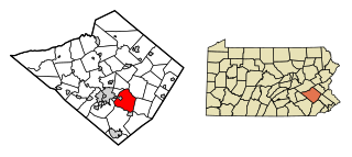
Montgomery County, colloquially referred to as Montco, is a county in the Commonwealth of Pennsylvania. As of the 2020 census, the population of the county was 856,553, making it the third-most populous county in Pennsylvania after Philadelphia and Allegheny counties. The county is part of the Southeast Pennsylvania region of the state.

<span class="mw-page-title-main">Brecknock Township, Berks County, Pennsylvania</span> Township in Pennsylvania, United States

Brecknock Township is a township in Berks County, Pennsylvania, United States. The population was 4,618 at the 2020 census.

<span class="mw-page-title-main">Exeter Township, Berks County, Pennsylvania</span> Township in Pennsylvania, United States

Exeter Township is a township in Berks County, Pennsylvania, United States. The population was 25,500 as of the 2020 census, making it the third-most populous municipality in Berks County after the city of Reading and Spring Township. Daniel Boone Homestead is within its borders. This formerly rural township is now made up of mostly sprawl-oriented developments along U.S. Route 422 and Route 562 Its school district also contains the adjacent borough of St. Lawrence.

<span class="mw-page-title-main">Fleetwood, Pennsylvania</span> Borough in Pennsylvania, United States

Fleetwood, also called Schlegelschteddel in Pennsylvania Dutch, is a borough in Berks County, Pennsylvania, United States. The population was 4,049 at the 2020 census. It was home to the Fleetwood Metal Body company, an automobile coachbuilder purchased by Fisher Body and integrated into General Motors in 1931. The name lived on in the Cadillac Fleetwood automobile.

<span class="mw-page-title-main">Kutztown, Pennsylvania</span> Borough in Pennsylvania, United States

Kutztown is a borough in Berks County, Pennsylvania, United States. It is located 18 miles (29 km) southwest of Allentown and 17 miles (27 km) northeast of Reading. As of the 2020 census, the borough had a population of 4,162. Kutztown University of Pennsylvania is located just outside the borough limits to the southwest.

<span class="mw-page-title-main">Maxatawny Township, Pennsylvania</span> Township in Pennsylvania, United States

Maxatawny Township is a township in Berks County, Pennsylvania, United States. The population was 7,906 at the 2010 census.

<span class="mw-page-title-main">Lower Makefield Township, Pennsylvania</span> Township in Pennsylvania, United States

Lower Makefield Township is a township in Bucks County, Pennsylvania, United States. Lower Makefield Township is located in the Delaware Valley and borders the Delaware River and New Jersey to its north and east. Most addresses in the township have a Yardley address; the township surrounds the borough of Yardley on its north, south, and west.

<span class="mw-page-title-main">North Coventry Township, Pennsylvania</span> Township in Pennsylvania, United States

North Coventry Township is a township in Chester County, Pennsylvania, United States. The population was 7,866 at the 2010 census.

<span class="mw-page-title-main">Hampden Township, Pennsylvania</span> Township in Pennsylvania, United States

Hampden Township is the largest municipality by population in Cumberland County, Pennsylvania, United States. The population was 28,044 at the 2010 census, up from 24,135 at the 2000 census.

<span class="mw-page-title-main">West Earl Township, Pennsylvania</span> Township in Pennsylvania, United States

West Earl Township is a township in northeastern Lancaster County, Pennsylvania, United States. The population was 8,565 at the 2020 census. The township was founded by its first settler, Hans Conrad Groff (1661-1746) in 1717.

<span class="mw-page-title-main">Collegeville, Pennsylvania</span> Borough in Pennsylvania, United States

Collegeville is a borough in Montgomery County, Pennsylvania, a suburb outside of Philadelphia on Perkiomen Creek. Collegeville was incorporated in 1896. It is the location of Ursinus College, which opened in 1869. The population was 5,089 at the 2010 census.

<span class="mw-page-title-main">Franconia Township, Pennsylvania</span> Township in Pennsylvania, United States

Franconia Township is a township in Montgomery County, Pennsylvania, United States. The population was 13,064 at the 2010 census.

<span class="mw-page-title-main">Harleysville, Pennsylvania</span> Census-designated place in Pennsylvania, United States

Harleysville is a census-designated place (CDP) in Montgomery County, Pennsylvania, United States. It is a suburb of Philadelphia. The population was 9,286 at the 2010 census. It is located mostly within Lower Salford Township and also in Franconia Township. Harleysville was settled by Pennsylvania Dutch in the 18th century and was named after Samuel Harley.

<span class="mw-page-title-main">Lower Frederick Township, Pennsylvania</span> Township in Pennsylvania, United States

Lower Frederick Township is a township in Montgomery County, Pennsylvania, United States. The population was 4,840 at the 2010 census.

<span class="mw-page-title-main">Marlborough Township, Pennsylvania</span> Township in Pennsylvania, United States

Marlborough Township is a township in Montgomery County, Pennsylvania, United States. The population was 3,178 at the 2010 census.

<span class="mw-page-title-main">Salford Township, Pennsylvania</span> Township in Pennsylvania, United States

Salford Township is a township in Montgomery County, Pennsylvania, United States. The population was 2,504 at the 2010 census.

<span class="mw-page-title-main">Skippack, Pennsylvania</span> Census-designated place in Pennsylvania, United States

Skippack, originally named "Van Bebber's Township", is a census-designated place (CDP) in Skippack Township, Montgomery County, Pennsylvania, United States. The population was 3,758 at the 2010 census.

<span class="mw-page-title-main">Skippack Township, Pennsylvania</span> Township in Pennsylvania, United States

Skippack Township is a township in Montgomery County, Pennsylvania, United States. The population was 14,408 in 2022 according to the Census Bureau. This represents a 5.1% increase from the 2010 Census.

<span class="mw-page-title-main">Upper Frederick Township, Pennsylvania</span> Township in Pennsylvania, United States

Upper Frederick Township is a township in Montgomery County, Pennsylvania, United States. The population was 3,703 at the 2020 census.

<span class="mw-page-title-main">Warrington Township, York County, Pennsylvania</span> Township in Pennsylvania, United States

Warrington Township is a township in York County, Pennsylvania, United States. The population was 4,547 at the 2020 census. The township is named after Warrington, England, like many townships having English names in York County. Others dispute the origin, believing it may be named after Waringstown, County Down, now in Northern Ireland.

References

  1. "2016 U.S. Gazetteer Files". United States Census Bureau. Retrieved August 14, 2017.
  2. "Population and Housing Unit Estimates" . Retrieved June 9, 2017.
  3. "History". Lower Salford Township. Lower Salford Township. Retrieved January 17, 2015.
  4. "W.S. Hancock Society". W.S. Hancock Society. Retrieved January 17, 2015.
  5. "Heckler Plains Folklife Society". Heckler Plains Folklife Society. Retrieved January 17, 2015.
  6. "Head Into the Past at Hecklerfest". Montgomery Media. Retrieved January 17, 2015.
  7. Pennsylvania Historical and Museum Commission, 1972, NRHP Nomination Form for Klein Meetinghouse Enter "public" for ID and "public" for password to access the site.
  8. "National Historic Landmarks & National Register of Historic Places in Pennsylvania" (Searchable database). CRGIS: Cultural Resources Geographic Information System.Note: This includes Pennsylvania Register of Historic Sites and Landmarks (June 1972). "National Register of Historic Places Inventory Nomination Form: Dielman Kolb Homestead" (PDF). Retrieved May 14, 2012.
  9. "National Register Information System". National Register of Historic Places . National Park Service. July 9, 2010.
  10. "Lederach Golf Club". Lower Salford Township. Retrieved January 17, 2015.
  11. "Lederach Golf Club". Lederach Golf Club. Retrieved January 17, 2015.
  12. "Parks and Open Spaces". Lower Salford Township. Retrieved January 17, 2015.
  13. "Flag". Lower Salford Township. Retrieved January 17, 2015.
  14. "Mennonite Heritage Center". Mennonite Heritage Center. Retrieved January 17, 2015.
  15. "Apple Butter Frolic". Mennonite Heritage Center. Retrieved January 17, 2015.
  16. "Montco Election Results".
  17. "Elected Officials". Lower Salford Township. Retrieved January 17, 2015.
  18. "DVRPC > Site Search". Archived from the original on April 9, 2019. Retrieved March 21, 2014.
  19. "Census 2020".
  20. "Census 2010: Pennsylvania - USATODAY.com". USA TODAY News. Retrieved July 27, 2020.
  21. "U.S. Census website". United States Census Bureau . Retrieved January 31, 2008.
  22. "Lower Salford Township map" (PDF). PennDOT. Retrieved March 10, 2023.