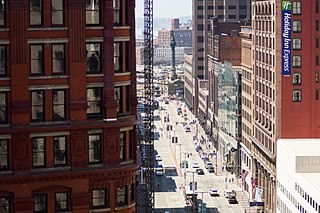
Euclid Avenue is a major street in Cleveland, Ohio. It runs northeasterly from Public Square in Downtown Cleveland, passing Playhouse Square and Cleveland State University, to University Circle, the Cleveland Clinic, Severance Hall, Case Western Reserve University's Maltz Performing Arts Center, Case Western Reserve University and University Hospitals Case Medical Center. The street runs through the suburbs of East Cleveland, Euclid, and Wickliffe, to Willoughby as a part of U.S. Route 20 and U.S. Route 6. The HealthLine bus rapid transit line runs in designated bus lanes in the median of Euclid Avenue from Public Square to Louis Stokes Station at Windermere in East Cleveland.
The Central Area, commonly called the Central District or The CD, is a mostly residential district in Seattle located east of downtown and First Hill ; west of Madrona, Leschi and Mt. Baker; south of Capitol Hill, and north of Rainier Valley. Historically, the Central District has been one of Seattle's most racially and ethnically diverse neighborhoods, and was once the center of Seattle's black community and a major hub of African-American businesses.

University Circle is a district in the neighborhood of University on the East Side of Cleveland, Ohio. One of America's densest concentrations of cultural attractions and performing arts venues, it includes such world-class institutions as the Cleveland Museum of Art; Severance Hall ; the Cleveland Institute of Art; Case Western Reserve University; the Cleveland Institute of Music; the Museum of Contemporary Art Cleveland; the Cleveland Botanical Garden; historic Lake View Cemetery; the Cleveland Museum of Natural History; and University Hospitals/Case Medical Center.

Karamu House in the Fairfax neighborhood on the east side of Cleveland, Ohio, United States, is the oldest African-American theater in the United States opening in 1915. Many of Langston Hughes's plays were developed and premièred at the theater.

Playhouse Square is a theater district in downtown Cleveland, Ohio, United States. It is the largest performing arts center in the US outside of New York City. Constructed in a span of 19 months in the early 1920s, the theaters were subsequently closed down, but were revived through a grassroots effort. Their renovation and reopening helped usher in a new era of downtown revitalization in Cleveland, and was called "one of the top ten successes in Cleveland history."

Downtown Cleveland is the central business district of Cleveland, Ohio. The economic and symbolic center of the city and the Cleveland-Akron-Canton, OH Combined Statistical Area, it is Cleveland's oldest district, with its Public Square laid out by city founder General Moses Cleaveland in 1796.

Collinwood is a historical area on the East Side of Cleveland, Ohio. Originally a village in Euclid Township, it was annexed by the city in 1910. Collinwood grew around the rail yards of the Lake Shore and Michigan Southern Railway and is divided by these same tracks into the neighborhoods of North Shore Collinwood and Collinwood–Nottingham. Collinwood was identified as one of America's Best Secret Neighborhoods by Travel + Leisure in 2008.
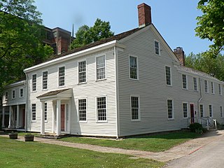
The Dunham Tavern, also known as the Dunham Tavern Museum, is the oldest building in Cleveland, Ohio, located at 6709 Euclid Avenue. Rufus and Jane Pratt Dunham built their first home on the site in 1824, and the existing taproom was built in 1842. It is believed to be the first building constructed on Euclid Avenue east of East 55th Street and the first frame house on the street. It later became a stagecoach stop and tavern.
The Near East Side is a neighborhood located near downtown Columbus, Ohio, made up of several neighborhoods: Mount Vernon, King-Lincoln Bronzeville, Eastgate, Franklin Park, Nelson Park, Olde Towne East, and Woodland Park.
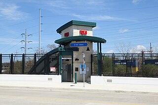
East 105th–Quincy is a station on the RTA Red Line in Cleveland, Ohio. It is located in the Fairfax neighborhood, on the city's east side. The station has a small entrance on the north side of Quincy Avenue.

St. Clair–Superior is a neighborhood on the East Side in Cleveland, Ohio, in the United States. Largely settled in the 1880s and 1890s by Eastern European immigrants, white flight in the 1990s left the neighborhood largely African American. It is one of the oldest and most culturally diverse neighborhoods in Cleveland today.

The HealthLine is a bus rapid transit (BRT) line run by the Greater Cleveland Regional Transit Authority in Cleveland and East Cleveland, Ohio, United States. The line runs along Euclid Avenue from Public Square in downtown Cleveland to the Louis Stokes Station at Windermere in East Cleveland. It began operation on October 24, 2008. Its current name was the result of a naming rights deal with the Cleveland Clinic and University Hospitals of Cleveland. The HealthLine is denoted with a silver color and abbreviated simply as HL on most RTA publications.
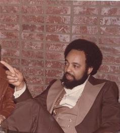
Winston Earl Willis is an American former real estate developer who established his business in Cleveland, Ohio during the early 1960s. He created University Circle Properties Development, Inc., which owned real estate parcels in Cleveland and was the largest employer of black people in that part of the country. Under UCPD at East 105th and Euclid, upwards of 23 businesses operated simultaneously. In the 1970s and 80s Willis ran afoul of tax and other laws and lost his properties to seizure in 1983. His ongoing legal battles with the city of Cleveland over ownership of his lands spans several decades, including his 2007 petition to the U.S. Supreme Court.
University Circle Properties Development, Inc. was a commercial property development corporation established in 1968 in Cleveland Ohio. Located in the University Circle area at the famous intersection of Euclid Avenue and East 105th Street, the area came to be known colloquially during the 1960s and 1970s as "105 and Euclid" and "The Block". Founded by a young African-American businessman, Winston E. Willis, UCPD, Inc. was the umbrella organization for a number of thriving businesses on the lower East side. After operating successfully for over fifteen years, and following decades of courtroom confrontations and legal battles over property rights, UCPD, Inc. and all of its popular 105th and Euclid businesses were demolished in 1982 to make way for the continuing expansion of the Cleveland Clinic Foundation and numerous government sponsored redevelopment projects.

First Methodist Church is a historic church in the Central neighborhood on the east side of Cleveland, Ohio.

Zion Lutheran Church is a historic Lutheran church located along Prospect Avenue near downtown Cleveland, Ohio, United States. Formed in the 1840s, the congregation built the present building shortly after 1900, along with an adjacent church school. Both buildings have been named historic sites. The school is no longer open.

East 105th Street and Euclid Avenue was at one time the most famous intersection in the city of Cleveland, Ohio. The legendary commercial junction consists of several blocks from East to West between 107th Street and 105th Street.
Central, also known as Cedar–Central, is a neighborhood on the East Side of Cleveland, Ohio. Situated on the outskirts of downtown, Central is bounded roughly by East 71st Street on its east and Interstate 90 on its west, with Euclid Avenue on its north and Interstate 77 and the Penn Central Railroad to the south. The neighborhood is eponymously named for its onetime main thoroughfare, Central Avenue. It is home to several schools, including East Technical High School.
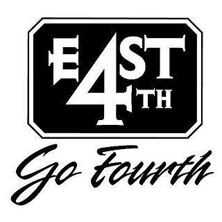
East 4th Street is a major downtown district in Cleveland, Ohio, known for its food, entertainment, and lack of car traffic. The street runs south from Euclid Avenue to Prospect Avenue. Once a very run down street, the area has been renovated and revitalized by the establishment of numerous restaurants, bars, nightclubs, and apartments, turning it into one of the main nightlife hotspots in the city.

The Campus District is a Downtown Cleveland, Ohio district that includes the campuses of Cleveland State University, St. Vincent Charity Medical Center, and the Cuyahoga Community College (Tri-C) Metro Campus. Definitions of the district vary. According to the Cleveland City Planning Commission, the district is bounded by Payne Avenue to the north, East 17th Street to the west, and Interstate 90 to the south and east, forming the boundary between Downtown and Cleveland's Central neighborhood. However, the Campus District association places the western boundary of the district to East 18th Street and the eastern boundary further east, to East 30th Street, including Tri-C, with Interstate 77 to the south.

