Fairwater, Torfaen

Last updated

Fairwater
Fairwater Primary School, Henllys Way, Cwmbran - geograph.org.uk - 398305.jpg
Fairwater Primary School
Torfaen UK location map.svg
Red pog.svg
Fairwater
Location within Torfaen
Area5.24 km2 (2.02 sq mi)  [1]
Population11,632 (2011) [2]
  Density 2,220/km2 (5,700/sq mi)
OS grid reference ST 276 945
Community
  • Fairwater
Principal area
Ceremonial county
Country Wales
Sovereign state United Kingdom
Post town CWMBRAN
Postcode district NP44
Dialling code 01633
Police Gwent
Fire South Wales
Ambulance Welsh
UK Parliament
Senedd Cymru – Welsh Parliament
List of places
UK
Wales
Torfaen
51°38′41″N3°02′52″W / 51.64462°N 3.04773°W / 51.64462; -3.04773 Coordinates: 51°38′41″N3°02′52″W / 51.64462°N 3.04773°W / 51.64462; -3.04773

Fairwater is a community and suburb of Cwmbran in the county borough of Torfaen, in south east Wales, and was built by the Cwmbran Development Corporation between 1963 and 1966.

Contents

Development

Cwmbran was the only new town in Wales designated by the New Towns Act 1946. [3] Cwmbran Development Corporation was formed in 1949 to develop the new town and building of seven new residential areas (Coed Eva, Croesyceiliog North and South, Greenmeadow, Oakfield, Pontnewydd, and St Dials) began in 1951, later followed by Llanyrafon. [4] [5]

By 1962, when Gordon Redfern took over as chief architect of the corporation, the increased use of cars had to be accommodated in the layout of further housing estates, and Redfern adopted the Radburn system, used most rigidly in Fairwater (built between 1963 and 1966). [5]

Notable buildings

The remains of Llanderfel Chapel, a medieval chapel important as a stopping point on a pilgrims' route to Penrhys, are in Fairwater. [6] [7] The pilgrim route is now part of the modern long distance Cistercian Way footpath. [8] The remains are a scheduled monument. [6]

Near the site of the chapel is Llanderfel Farm, a 16th-17th century Grade II listed building. [9] Also nearby is Ty'r Ywen Farmhouse and barn which are both 17th century Grade II listed buildings. [10] [11]

Education

There are three primary (infant and junior) schools in Fairwater community:

Cwmbran High (one of two secondary schools in Cwmbran, the other is Croesyceiliog School) is also located in Fairwater. [15] [16]

Governance

The community of Fairwater also includes the estates of Coed Eva, Greenmeadow, and Ty Canol, and includes three electoral wards for Torfaen County Borough Council: [17] [18]

Related Research Articles

Cwmbran Human settlement in Wales

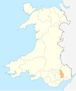
Cwmbran is a town in the county borough of Torfaen in South Wales.

Torfaen County borough

Torfaen is a county borough in Wales within the historic boundaries of Monmouthshire. It was originally formed in 1974 as a district of the county of Gwent and in 1996 it was reconstituted as a principal area.

Pontypool Human settlement in Wales

Pontypool is a town and the administrative centre of the county borough of Torfaen, within the historic boundaries of Monmouthshire in South Wales. It has a population of over 28,000.

Croesyceiliog Human settlement in Wales

Croesyceiliog is a suburb of Cwmbran, Wales.

New Inn Human settlement in Wales

New Inn - - is a village and community directly south east of Pontypool, within the County Borough of Torfaen in Wales, within the historic boundaries of Monmouthshire. It had a population of over 5,000.

Llanyrafon Human settlement in Wales

Llanyrafon is a suburb of Cwmbran and a community in the county borough of Torfaen in south east Wales. It lies within the boundaries of the historic county of Monmouthshire and the preserved county of Gwent.

Greenmeadow is a suburb of Cwmbran in the county borough of Torfaen, within the historic county boundaries of Monmouthshire, southern Wales, United Kingdom.

Sebastopol is the southernmost suburb of Pontypool in the county borough of Torfaen, within the historic boundaries of Monmouthshire in South Wales. It is named in honour of the Crimean city Sevastopol that was taken during the Crimean War. It is a working-class area consisting of mainly privately owned terraced houses and a substantial number of local authority/ex-local authority housing.

Fairwater High School, now known as Cwmbran High School, is a state-funded and non-selective comprehensive school in the Fairwater district of Cwmbran, Wales. The school is one of two secondary schools in Cwmbran, the other being Croesyceiliog. It educates children from the age of 11 up to 18. The school also houses the community swimming pool. Construction began in 1969 and was to replace the secondary modern in Coed Eva, opened in 1960, that had to become a primary school in order to accommodate the growing younger population in Cwmbran New Town. In 2015, as part of Torfaen County's 21st Century Schools Programme, Llantarnam School, one of the original Cwmbran New Town schools, closed and was merged with Fairwater High to form a new school on the latter site. It opened in September of that year as Cwmbran High School.

Monmouthshire County Council

Monmouthshire County Council is the governing body for the Monmouthshire principal area – one of the unitary authorities of Wales.

Afon Lwyd River in south-east Wales

The Afon Lwyd is a 13-mile (21 km) long river in south-east Wales which flows from its source north of Blaenavon, through Abersychan, Pontnewynydd, Pontypool, Llanfrechfa and Cwmbran before flowing into the River Usk at Caerleon, which subsequently flows into the Bristol Channel in Newport.

Cwmavon, Torfaen Human settlement in Wales

Cwmavon is a hamlet about 2 miles south of Blaenavon and 4 miles north of Pontypool. The hamlet is part of the community of Abersychan in the county borough of Torfaen in south east Wales, and is within the boundaries of the historic county of Monmouthshire.

Llantarnam Grange Arts Centre

Llantarnam Grange Arts Centre is located within a 19th-century Victorian manor house in Cwmbrân and is the regional centre for the applied arts in south-east Wales. It presents exhibitions promoting the applied arts, and extensive education and participation schemes of work to the local community.

<i>Pontypool Free Press</i>

The Pontypool Free Press is an English language weekly regional newspaper that was originally published in Pontypool, as the Pontypool Free Press and Herald of the Hills, in 1859 and is circulated in Pontypool and the surrounding area of Torfaen, in south-east Wales.

Gwent County Council

Gwent County Council was the upper-tier local authority that governed the county of Gwent in South Wales from its creation in 1974 to its abolition in 1996. It was created by the Local Government Act 1972 and abolished by the Local Government (Wales) Act 1994.

County Hall, Cwmbran

County Hall was a municipal facility on Turnpike Road in Croesyceiliog in Cwmbran in Wales. It was the headquarters of Gwent County Council from 1978 to 1996 and of Monmouthshire County Council from 1996 to 2013.

References

  1. "2011 Census:Quick Statistics:Population Density for Fairwater". Office for National Statistics. Retrieved 29 November 2013.
  2. "2011 Census:Key Statistics:Key Figures for Fairwater". Office for National Statistics. Retrieved 25 November 2013.
  3. Newman, John; Lynch, Frances; Manning, William; Hughes, Stephen (2002). "Cwmbran/Cwmbrân". Gwent/Monmouthshire. Pevsner Architectural Guides (The Buildings of Wales). New Haven & London: Yale University Press. p. 194. ISBN   978-0-300-09630-9. OCLC   45327986.
  4. Barber, Chris (1999). "The Afon Llwyd (example)". Eastern Valley - The Story of Torfaen (1st ed.). Llanfoist, Gwent: Blorenge Books. p. 181. ISBN   1-872730-23-X. OCLC   43459623.
  5. 1 2 Newman et al 2002, p. 205.
  6. 1 2 Leighton, D.; Driver, T. (5 October 2015). "Llanderfel Chapel". National Monuments Record of Wales (NMRW). Royal Commission on the Ancient and Historical Monuments of Wales (RCAHMW). NPRN 91617. Retrieved 29 April 2016 via coflein (online database of the NMRW).
  7. Gray, Madeleine (2006). "St Derfel's Chapel, Llandderfel". The Cistercian Way. Newport, Wales: Alliance of Religions and Conservation. Archived from the original on 11 August 2007. Retrieved 29 April 2016.
  8. Gray, Madeleine (2006). "Llantarnam to Risca". The Cistercian Way. Newport, Wales: Alliance of Religions and Conservation. Archived from the original on 11 August 2007. Retrieved 29 April 2016.
  9. "Llanderfel Farmhouse". Statutory List of Buildings . Cadw. 29 January 2003 [Listed 1987]. Cadw Building ID 3148. Retrieved 29 April 2016 via Historic Wales.
  10. "Ty'r Ywen Farmhouse". Statutory List of Buildings . Cadw. 29 January 2003 [Listed 2002]. Cadw Building ID 27059. Retrieved 29 April 2016 via Historic Wales.
  11. "Barn at Ty'r Ywen Farm". Statutory List of Buildings . Cadw. 29 January 2003 [Listed 2002]. Cadw Building ID 27060. Retrieved 29 April 2016 via Historic Wales.
  12. "Coed Eva Primary". Education & Learning. Pontypool: Torfaen County Borough Council . Retrieved 29 April 2016.
  13. "Henllys Church in Wales Primary". Education & Learning. Pontypool: Torfaen County Borough Council . Retrieved 29 April 2016.
  14. "Nant Celyn Primary". Education & Learning. Pontypool: Torfaen County Borough Council . Retrieved 29 April 2016.
  15. "Cwmbran High". Education & Learning. Pontypool: Torfaen County Borough Council . Retrieved 29 April 2016.
  16. "Croesyceiliog School". Education & Learning. Pontypool: Torfaen County Borough Council . Retrieved 29 April 2016.
  17. "Fairwater Community ID 64398". MapIt: UK. London: mySociety . Retrieved 29 April 2016.
  18. "Areas covered by Fairwater Community". MapIt: UK. London: mySociety . Retrieved 29 April 2016.
  19. "Results by ward: Coed Eva". Find Councillor. Pontypool: Torfaen County Borough Council . Retrieved 29 April 2016.
  20. "Results by ward: Fairwater". Find Councillor. Pontypool: Torfaen County Borough Council . Retrieved 29 April 2016.
  21. "Results by ward: Greenmeadow". Find Councillor. Pontypool: Torfaen County Borough Council . Retrieved 29 April 2016.