Cwmbran is a town in the county borough of Torfaen in South Wales.

Newport is a city and county borough in Wales, situated on the River Usk close to its confluence with the Severn Estuary, 12 mi (19 km) northeast of Cardiff. The population grew considerably between the 2011 and the 2021 census, rising from 145,700 to 159,587, the largest growth of any unitary authority in Wales. Newport is the third-largest principal authority with city status in Wales, and sixth most populous overall. Newport became a unitary authority in 1996 and forms part of the Cardiff-Newport metropolitan area, also known as the Cardiff Capital Region.

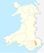
Torfaen is a county borough in the south-east of Wales. Torfaen is bordered by the county of Monmouthshire to the east, the city of Newport to the south, and the county boroughs of Caerphilly and Blaenau Gwent to the south-west and north-west. It is within the boundaries of the historic county of Monmouthshire, and between 1974 and 1996 was a district of Gwent, until it was reconstituted as a principal area in 1996.

Pontypool is a town and the administrative centre of the county borough of Torfaen, within the historic boundaries of Monmouthshire in South Wales. As of 2021, it has a population of 29,062.
Croesyceiliog is a suburb of Cwmbran, Wales.

New Inn - - is a village and community directly south east of Pontypool, within the County Borough of Torfaen in Wales, within the historic boundaries of Monmouthshire. It had a population of 5,986 at the 2011 Census.
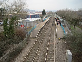
Cwmbran railway station is in the northeast of Cwmbran town centre, within five minutes' walking distance. It is part of the British railway system owned by Network Rail and is managed by Transport for Wales, who operate all trains serving it. It lies on the Welsh Marches Line from Newport to Hereford. The station was opened at this site in 1986 to serve the commuter route to Newport and Cardiff, and shoppers to the town centre.

Pontnewydd is a suburb of Cwmbran in the county borough of Torfaen, south-east Wales. It should not be confused with Pontnewynydd in nearby Pontypool.

Fairwater is a community and suburb of Cwmbran in the county borough of Torfaen, in south east Wales, and was built by the Cwmbran Development Corporation between 1963 and 1966.

Llantarnam is a village of Cwmbran, and is a community and electoral ward in the county borough of Torfaen in south east Wales. The ward covers the same area as the community, but also includes Southville. It is equidistant from Cwmbran town centre and the town of Caerleon.
Griffithstown is a large suburb of Pontypool in the borough of Torfaen, Wales, within the historic boundaries of Monmouthshire. It is an ecclesiastical parish, formed in May 1898, from Llanfrechfa Upper and Panteg, and includes Sebastopol, but, under the provisions of the Local Government Act 1894, became a separate civil parish.

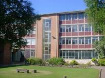
Croesyceiliog School is a state-funded secondary school in the Croesyceiliog area of Cwmbran, in South Wales, UK.
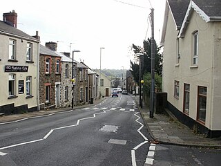
Sebastopol is the southernmost suburb of Pontypool in the county borough of Torfaen, within the historic boundaries of Monmouthshire in South Wales. It is named in honour of the Crimean city Sevastopol that was taken during the Crimean War. It is a working-class area consisting of mainly privately owned terraced houses and a substantial number of local authority/ex-local authority housing.

The Boating Lake Park is a large public park in Cwmbran, Torfaen in Wales. As its name suggests, the park features a boating lake. There are in fact two lakes, the larger being home to various wetland birds and the smaller being the actual boating one. Water area is 5 acres (20,000 m2). The park is bordered by the Afon Llwyd on one side and a railway line on the other.
Old Cwmbrân is an area of Cwmbrân, Torfaen in Wales, within the historic boundaries of Monmouthshire.
Thornhill is a large council estate on the western side of Cwmbran, Torfaen in Wales. It is adjacent to the suburbs of Greenmeadow and Upper Cwmbran and represents the most economically-improved area of Cwmbran and in the wider Torfaen area. The estate is large and sprawling, built in the mid-1970s as temporary housing during the redevelopment of Pillgwenlly. The residents liked the houses and never left. It is built around the original Thornhill farm house, which is still situated in the middle of the estate. The farm originally farmed pigs, and the woodland now surrounding the main estate has remains of the old walls and pig sties. The estate is divided into small cul de sacs that are named after Welsh rivers or lakes. The main thoroughfare is Hafren Road.
The Newport and District Football League is a football league covering the city of Newport and surrounding areas in South Wales. The headquarters are located at Newport Civic Centre.

Llantarnam Grange Arts Centre is located within a 19th-century Victorian manor house in Cwmbrân and is the regional centre for the applied arts in south-east Wales. It presents exhibitions promoting the applied arts, and extensive education and participation schemes of work to the local community.
Henllys means 'ancient court' with hen 'ancient' and llys 'court'. The name may refer to the former administrative court of the lordship of Machen Today Henllys is a residential area and community on the edge of Cwmbrân in South East Wales, with a population of 2,682 as of the 2011 census.