Falcon, Colorado

Last updated

Falcon, Colorado
USA Colorado location map.svg
Red pog.svg
Falcon
Coordinates: 38°55′58″N104°36′30″W / 38.93278°N 104.60833°W / 38.93278; -104.60833
Country United States
State Colorado
County El Paso
Elevation
[1]
6,831 ft (2,082 m)
Population
 (2009)
  Total10,514
Time zone UTC-7 (Mountain Standard Time)
  Summer (DST) UTC-6 (Mountain Daylight Time)
ZIP code
80831 (Peyton)
Area code 719

Falcon is an unincorporated community exurb in El Paso County, Colorado, United States. It lies along US 24 about 14 miles northeast of Colorado Springs. A railroad hub in the early 20th century, the town spent several decades as a quiet ranching community until it experienced rapid residential growth throughout the 1990s which has continued increasingly through today. The population of Falcon as of 2009 was estimated to be 10,514. [2] The U.S. Post Office in Peyton, Colorado (ZIP Code 80831) serves Falcon postal addresses. [3]

Contents

History

Falcon, Colorado Falcon Colorado by David Shankbone.jpg
Falcon, Colorado
The fire station Falcon Colorado Fire Station.jpg
The fire station

In 1888, the area now known as "Falcon" was crossed by the railroads: first the Denver and New Orleans on a rail bed parallel to today's Eastonville Road in 1882, then the Chicago and Rock Island on a rail bed parallel to today's U.S. Highway 24 during 1888. The lines' intersection remains an important center of the Falcon area today. [4]

On September 20, 1888, the first announcement of "Falcon, Colorado" was advertised in the Colorado Springs Gazette . The Falcon Land and Town Company, associated with the Chicago Rock Island Railroad, were selling lots to individuals. By 1896, there were two hotels, a newspaper, six saloons, a pool hall, stockyards, two train depots, two general stores, a blacksmith shop and a school. [5]

The introduction of the automobile brought a decline in passenger rail traffic to Falcon. A 1935 flood washed out the Colorado & Southern tracks, which weren't rebuilt, and the Rock Island railroad junction closed. [4] By 1975, only a small number of homes and the school remained near the Falcon intersection.

In 1984, a business complex including a convenience store and gas station was built at the intersection of Meridian Road and U.S. 24; the intersection gained a traffic light in 1996. [5] In the early 1990s, Falcon began residential development at a rapid pace [6] and the area's population nearly doubled between 1990 and 2000. [7]

With the rapid growth, suburban amenities began appearing in Falcon. Safeway opened a grocery store in 2000. [8] El Paso County approved a new Wal-Mart store in 2005 with minimal opposition. [9] As that new retail presence was preparing to open, residents voted in May 2007 on whether to incorporate as a town. The proposal was defeated, with 78% of the vote against incorporation. [10] The next major retail chain slated to set up shop in Falcon was Lowe's, which had agreed to procure the current site of Fire Station #1 of the Falcon Fire Protection District. Lowe's would have built a replacement station near Golden Sage Rd. and Woodmen Rd., but in September 2008 that deal fell through, and Lowe's did not complete the transaction. [11]

Geography

Falcon coordinates are 38.9383° N, 104.6009° W. It is 14 miles northeast of downtown Colorado Springs, which sources services that are unavailable in Falcon. Falcon is primarily a region of semi-arid steppe grassland, and has a dry season in the fall and spring with a monsoon period towards the end of summer. North of Falcon is Black Forest, a forested area primarily filled with dark evergreen and pine trees.

Neighborhoods

Falcon neighborhoods include: Antler's Ridge, The Meadows, Elkhorn Estates, Meridian Ranch, Woodmen Hills, Paint Brush Hills (which is now the name of the neighborhood formerly known as "Falcon Hills"), Falcon Heights, and Sunny Slope Estates (an older Falcon neighborhood established in the late '70s, early '80s with 5+ acre parcels zoned for livestock, bordered by Falcon Highway and East Blaney Road). This area has some springs, ponds, and older trees.

Airport

Meadow Lake Airport (FLY; ICAO: KFLY) has been in operation since 1967. It is located southeast of Highway 24 and Judge Orr Road in east Falcon. Meadow Lake is a pilot owned airport available for public use. [12] It is designated as a general aviation reliever airport.

Arts and culture

The Black Squirrel Creek Bridge, a property listed on the National Register of Historic Places, is located between Falcon and Peyton, Colorado. Because it no longer met highway safety standards, the bridge was dismantled and replaced by a newer span in 2012. [13]

On October 16, 2010, High Prairie Library, a branch of the Pikes Peak Library District, opened to the public.

In 2004, the Antler Creek Golf Course opened as the longest golf course in Colorado and the second-longest in the nation. [14]

Education

Geographically, students are served by Falcon School District 49, but some choose to attend other school districts in El Paso County instead. District 49 currently has four high schools: Falcon High School, Vista Ridge High School, Sand Creek High School and the Patriot Learning Center. The area's rapid growth has caused the district to grow by 1,100 new students annually over the past few years. [7]

Religion

Falcon is home to many churches and religious organizations including Falcon Baptist Church, Family of Faith Lutheran Church, Gathering Stones Community Church, Grace Community Church Meridian Point Church, missio Dei: Falcon, Sagecreek Community Church, St. Benedict Catholic Church, The Church of Jesus Christ of Latter-day Saints, and the Thai Buddhist Wat Buddhanimit Temple Archived June 20, 2018, at the Wayback Machine .

Related Research Articles

<span class="mw-page-title-main">Colorado Springs, Colorado</span> City in Colorado, United States

Colorado Springs is a city in and the county seat of El Paso County, Colorado, United States. It is the most populous city in El Paso County, with a population of 478,961 at the 2020 census, a 15.02% increase since 2010. Colorado Springs is the second-most populous city and the most extensive city in the state of Colorado, and the 39th-most-populous city in the United States. It is the principal city of the Colorado Springs metropolitan area and the second-most prominent city of the Front Range Urban Corridor. It is located in east-central Colorado on Fountain Creek, 70 miles (113 km) south of Denver.

<span class="mw-page-title-main">El Paso County, Colorado</span> County in Colorado, United States

El Paso County is the most populous county located in the U.S. state of Colorado. As of the 2020 Census, the population was 730,395, surpassing the City and County of Denver. The county seat is Colorado Springs, the second most populous city in Colorado. El Paso County is included in the Colorado Springs, Colorado, Metropolitan Statistical Area.

<span class="mw-page-title-main">Scouting in Colorado</span> History of the scouting movement in Colorado

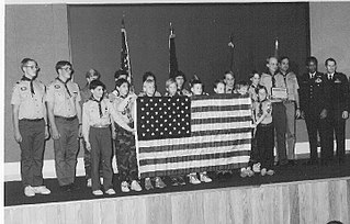
Scouting in Colorado has a long history, from the 1910s to the present day.

<span class="mw-page-title-main">Arvada, Colorado</span> City in Colorado, United States

Arvada is a home rule municipality on the border between Jefferson and Adams counties, Colorado, United States. The city population was 124,402 at the 2020 United States Census, with 121,510 residing in Jefferson County and 2,892 in Adams County. Arvada is the seventh most populous city in Colorado. The city is a part of the Denver–Aurora–Lakewood, CO Metropolitan Statistical Area and the Front Range Urban Corridor. The Olde Town Arvada historic district is 7 miles (11 km) northwest of the Colorado State Capitol in Denver.

<span class="mw-page-title-main">Westminster, Colorado</span> City in Colorado, United States

The City of Westminster is a home rule municipality located in Adams and Jefferson counties, Colorado, United States. The city population was 116,317 at the 2020 United States Census with 71,240 residing in Adams County and 45,077 residing in Jefferson County. Westminster is the eighth most populous city in Colorado. The city is a part of the Denver–Aurora–Lakewood, CO Metropolitan Statistical Area and the Front Range Urban Corridor. The Westminster Municipal Center is located 9 miles (14 km) north-northwest of the Colorado State Capitol in Denver.

<span class="mw-page-title-main">Meridian, Colorado</span> Census Designated Place in Colorado, United States

Meridian is an unincorporated community and a census-designated place (CDP) located in and governed by Douglas County, Colorado, United States. The CDP is a part of the Denver–Aurora–Lakewood, CO Metropolitan Statistical Area. The population of the Meridian CDP was 4,786 at the United States Census 2020. The CDP lies in ZIP code 80112.

<span class="mw-page-title-main">Monument, Colorado</span> Town in Colorado, United States

Monument is a home rule town situated at the base of the Rampart Range in El Paso County, Colorado, United States. Monument is one of the three communities that make up the Tri-Lakes area, along with Palmer Lake and Woodmoor. The town is part of the Colorado Springs metropolitan area, which had an estimated population of 700,000 in 2019. Monument is bordered by Pike National Forest on the west, Colorado Springs and the United States Air Force Academy to the south, Bald Mountain, True Mountain, and Spruce Mountain to the north, and Black Forest and rolling plains to the east. Monument was first settled as a stop along the Rio Grande Railroad in 1872, and the area was incorporated as a town called Henry's Station in 1879, but the name was later changed to Monument. The town population was 10,399 at the 2020 United States Census, an increase from the population of 5,530 in 2010 and 1,971 in 2000. On April 1, 2019, the town declared itself to be a Second Amendment sanctuary.

<span class="mw-page-title-main">Palmer Lake, Colorado</span> Town in Colorado, United States

Palmer Lake is a Statutory Town in El Paso County, Colorado, United States. The population was 2,636 at the 2020 census. Palmer Lake was founded by General William Jackson Palmer in 1871 and was incorporated in 1889.

<span class="mw-page-title-main">Evergreen, Colorado</span> Census Designated Place in Colorado, United States

Evergreen is an unincorporated town, a post office, and a census-designated place (CDP) located in and governed by Jefferson County, Colorado, U.S. The CDP is a part of the Denver–Aurora–Lakewood, CO Metropolitan Statistical Area. The Evergreen post office has the ZIP Codes 80439 and 80437. At the 2020 census, the population of the Evergreen CDP was 9,307. The Evergreen Metropolitan District provides services.

<span class="mw-page-title-main">William Jackson Palmer</span> American engineer and veteran of the Civil War (1836–1909)

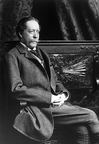
William Jackson Palmer was an American civil engineer and veteran of the American Civil War. During the Civil War, he was promoted to brevet brigadier general and received a Medal of Honor for his actions.

<span class="mw-page-title-main">Peyton, Colorado</span> Census Designated Place in Colorado, United States

Peyton is an unincorporated town, a post office, and a census-designated place (CDP) located in and governed by El Paso County, Colorado, United States. The CDP is a part of the Colorado Springs, CO Metropolitan Statistical Area. The Peyton post office has the ZIP Code 80831. At the United States Census 2020, the population of the Peyton CDP was 214.

<span class="mw-page-title-main">Falcon School District 49</span>

Falcon School District 49 (D49) is a public school district located on 133 square miles in the shadow of Pikes Peak. It spans from eastern Colorado Springs and several unincorporated areas of El Paso County.

<span class="mw-page-title-main">History of Colorado Springs, Colorado</span> Place in Colorado, United States

Before it was founded, the site of modern-day Colorado Springs, Colorado, was part of the American frontier. Old Colorado City, built in 1859 during the Pike's Peak Gold Rush was the Colorado Territory capital. The town of Colorado Springs was founded by General William Jackson Palmer as a resort town. Old Colorado City was annexed into Colorado Springs. Railroads brought tourists and visitors to the area from other parts of the United States and abroad. The city was noted for junctions for seven railways: Denver and Rio Grande (1870), Denver and New Orleans Manitou Branch (1882), Colorado Midland (1886-1918), Colorado Springs and Interurban, Atchison, Topeka, and Santa Fe (1889), Rock Island (1889), and Colorado Springs and Cripple Creek Railways. It was also known for mining exchanges and brokers for the Cripple Creek Gold Rush.

<span class="mw-page-title-main">Colorado State Highway 83</span> Highway in Colorado

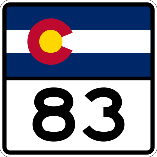
State Highway 83 (SH 83) is a state highway that is located along the Front Range in the U.S. State of Colorado. Spanning about 56.2 miles (90.4 km) from the SH 21 interchange in northern Colorado Springs and SH 2 in Denver, the highway follows a south–north route, paralleling Interstate 25 to the east and serving rural areas. Along with I-25, it is one of the only two routes in the Colorado State Highway System that directly connects Denver and Colorado Springs.

Eastonville is an extinct town in El Paso County, Colorado, United States. A post office named Easton opened on May 6, 1872, but the name was changed to Eastonville on September 28, 1883. The post office closed on May 11, 1932. Eastonville is no longer incorporated. The former town limits now lie in the Colorado Springs metropolitan area, near the Black Forest.

<span class="mw-page-title-main">Index of Colorado-related articles</span>

This is an alphabetical list of articles related to the U.S. State of Colorado.

<span class="mw-page-title-main">Colorado State Highway 21</span> Highway in Colorado

State Highway 21 (SH 21), also known as Powers Boulevard, is an expressway in El Paso County, in eastern Colorado Springs. SH 21 currently extends from SH 16 in Fountain at its southern end to Interquest Parkway/SH 83 in the north side of Colorado Springs. Extensions to I-25 near North Gate Boulevard are in progress, and extensions south to I-25 near Pikes Peak International Raceway are proposed, and the road is planned to be converted to a freeway in the long-term future.

<span class="mw-page-title-main">Outline of Colorado</span> Overview of and topical guide to Colorado

The following outline is provided as an overview of and topical guide to the U.S. state of Colorado:

Ivywild, Colorado, is a subdivision of Colorado Springs south of the downtown, west of Cascade Avenue and along Cheyenne Creek. As of 2015, the United States Geological Survey defines Ivywild as a Populated Place. It is one of the city's oldest working-class neighborhoods.

<span class="mw-page-title-main">Edgerton, Colorado</span>

Edgerton is an extinct town at the confluence of Monument Creek and West Monument Creek eight miles north of present-day Colorado Springs in El Paso County, Colorado, United States. It was across from Black Forest. The Edgerton post office operated from June 16, 1870, until August 28, 1902.

References

  1. "USGS detail on Falcon" . Retrieved September 27, 2007.
  2. Wilson, Jennifer (May 21, 2007). "Would town of Falcon have enough money?". The Gazette.
  3. "ZIP Code Lookup". United States Postal Service. January 6, 2009. Archived from the original (JavaScript/HTML) on November 22, 2010. Retrieved January 6, 2009.
  4. 1 2 Epstein, Warren (April 6, 1998). "New winds of change alter Falcon". p. Our Town 1.
  5. 1 2 Wilson, Dru (February 11, 1996). "Go East, young man, go East". The Gazette. p. City/State 1.
  6. Reuter, Jane (March 28, 2007). "Falcon takes wing". The Gazette. Archived from the original on May 24, 2011. Retrieved September 28, 2007. When the market turned around in the entire region, the market at Falcon Hills turned around with it. It was ultimately a success story.
  7. 1 2 Newsome, Brian (March 28, 2007). "Falcon's growing discontent". The Gazette. Archived from the original on May 24, 2011. Retrieved September 28, 2007.
  8. "Safeway Plans Supermarket in Falcon, Colo". Knight Ridder/Tribune Business News. February 21, 2000. Retrieved September 29, 2007.
  9. Laden, Rich (December 23, 2005). "County approves Wal-Mart in Falcon". The Gazette. Retrieved September 28, 2007.[ dead link ]
  10. Wilson, Jennifer (May 31, 2007). "Falcon says no to incorporation". The Gazette. Archived from the original on September 14, 2007. Retrieved September 28, 2007.
  11. Bliss, Lynne. "Lowe's transaction stalls, Ranchland News, September 11, 2008".
  12. "Meadow Lake Airport – CTAF-122.7—–AWOS-118.45—–FSS Denver-122.25" . Retrieved September 24, 2022.
  13. Colorado Department of Transportation programs page about the bridge. Retrieved June 29, 2019.
  14. Kensler, Tom (May 20, 2004). "Go the distance at Antler Creek". Denver Post. p. D-01. Demand for distance clubs figures to be high at Antler Creek, which will play 8,100 yards from the back tees, making it the first golf course in Colorado to stretch more than 8,000 yards and the second-longest in the nation, according to the Golf Course Superintendents Association of America.

Further reading

DENVER & NEW ORLEANS RAILROAD: IN THE SHADOW OF THE ROCKIES by James R. "Jim" Jones,1997, Sundance Publications, Denver, CO. Out of print.