Union Station, also known as Pennsylvania Station and commonly called Penn Station, is a historic train station in Downtown Pittsburgh, Pennsylvania. It was one of several passenger rail stations that served Pittsburgh during the 20th century; others included the Pittsburgh & Lake Erie Railroad Station, the Baltimore and Ohio Station, and Wabash Pittsburgh Terminal, and it is the only surviving station in active use.

Portland Union Station is a train station in Portland, Oregon, United States, situated near the western shore of the Willamette River in Old Town Chinatown. It serves as an intermediate stop for Amtrak's Cascades and Coast Starlight routes and, along with King Street Station in Seattle, is one of two western termini of the Empire Builder. The station is a major transport hub for the Portland metropolitan area with connections to MAX Light Rail, the Portland Streetcar, and local and intercity bus services. The station building contains Wilf's Restaurant & Bar on the ground level and offices on the upper floors. It also has Amtrak's first Metropolitan Lounge on the West Coast, which is reserved for first-class sleeping car and business-class passengers.

The F Market & Wharves line is one of several light rail lines in San Francisco, California. Unlike most other lines in the system, the F line runs as a heritage streetcar service, almost exclusively using historic equipment both from San Francisco's retired fleet as well as from cities around the world. While the F line is operated by the San Francisco Municipal Railway (Muni), its operation is supported by Market Street Railway, a nonprofit organization of streetcar enthusiasts which raises funds and helps to restore vintage streetcars.

The Embarcadero is the eastern waterfront of Port of San Francisco and a major roadway in San Francisco, California. It was constructed on reclaimed land along a three mile long engineered seawall, from which piers extend into the bay. It derives its name from the Spanish verb embarcar, meaning "to embark"; embarcadero itself means "the place to embark." The Central Embarcadero Piers Historic District was added to the National Register of Historic Places on November 20, 2002.

Embarcadero station is a combined BART and Muni Metro rapid transit subway station in the Market Street subway in downtown San Francisco. Located under Market Street between Drumm Street and Beale Street near The Embarcadero, it serves the Financial District neighborhood and surrounding areas. The three-level station has a large fare mezzanine level, with separate platform levels for Muni Metro and BART below. Embarcadero station opened in May 1976 – almost two years after service began through the Transbay Tube – as an infill station.
State Route 480 was a state highway in San Francisco, California, United States, consisting of the elevated double-decker Embarcadero Freeway, the partly elevated Doyle Drive approach to the Golden Gate Bridge and the proposed and unbuilt section in between. The unbuilt section from Doyle Drive to Van Ness Avenue was to have been called the Golden Gate Freeway and the Embarcadero Freeway as originally planned would have extended from Van Ness along the north side of Bay Street and then along the Embarcadero to the San Francisco-Oakland Bay Bridge.

The San Francisco Ferry Building is a terminal for ferries that travel across the San Francisco Bay, a food hall and an office building. It is located on The Embarcadero in San Francisco, California and is served by Golden Gate Ferry and San Francisco Bay Ferry routes.

Fort Mason, in San Francisco, California originated as a coastal defense site during the American Civil War. The nucleus of the property was owned by John C. Frémont and disputes over compensation by the United States continued into 1968. In 1882 the defenses were named for Richard Barnes Mason, a military governor before statehood. Fort Mason became the headquarters for an Army command that included California and the Hawaiian Islands from 1904 to 1907. In 1912 the Army began building a port facility with piers and warehouses to be a home base for ships of the Army Transport Service serving Alaska, Hawaii, the Philippines and other Pacific Army posts and focus of Army supply for the Pacific.
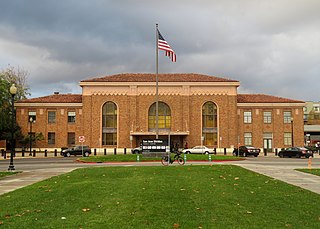
San Jose Diridon station is the central passenger rail depot for San Jose, California. It also serves as a major intermodal transit center for Santa Clara County and Silicon Valley. The station is named after former Santa Clara County Supervisor Rod Diridon Sr.

People in the San Francisco Bay Area rely on a complex multimodal transportation infrastructure consisting of roads, bridges, highways, rail, tunnels, airports, seaports, and bike and pedestrian paths. The development, maintenance, and operation of these different modes of transportation are overseen by various agencies, including the California Department of Transportation (Caltrans), the Association of Bay Area Governments, San Francisco Municipal Transportation Agency, and the Metropolitan Transportation Commission. These and other organizations collectively manage several interstate highways and state routes, eight passenger rail networks, eight trans-bay bridges, transbay ferry service, local and transbay bus service, three international airports, and an extensive network of roads, tunnels, and bike paths.

The Port of San Francisco is a semi-independent organization that oversees the port facilities at San Francisco, California, United States. It is run by a five-member commission, appointed by the Mayor and approved by the Board of Supervisors. The Port is responsible for managing the larger waterfront area that extends from the anchorage of the Golden Gate Bridge, along the Marina district, all the way around the north and east shores of the city of San Francisco including Fisherman's Wharf and the Embarcadero, and southward to the city line just beyond Candlestick Point. In 1968, the State of California, via the California State Lands Commission for the State-operated San Francisco Port Authority, transferred its responsibilities for the Harbor of San Francisco waterfront to the City and County of San Francisco / San Francisco Harbor Commission through the Burton Act AB2649. All eligible State port authority employees had the option to become employees of the City and County of San Francisco to maintain consistent operation of the Port of San Francisco.

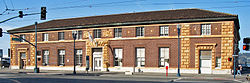
Santa Clara Transit Center is a railway station in downtown Santa Clara, California. It is served by Caltrain, Amtrak Capitol Corridor, and Altamont Corridor Express (ACE) trains. It is the planned terminus for the Silicon Valley BART extension into Santa Clara County on the future Green and Orange Lines. The former station building, constructed in 1863 by the San Francisco and San Jose Railroad, is used by the Edward Peterman Museum of Railroad History.

Sacramento Valley Station is an Amtrak railway station in the city of Sacramento, California, at 401 I Street on the corner of Fifth Street, built in 1926 on the site of China Slough. It is the thirteenth busiest Amtrak station in the country, and the second busiest in the Western United States. It is served by four different Amtrak train routes and connecting Amtrak Thruway motorcoaches. It is also the western terminus for the Gold Line of the Sacramento RT Light Rail system and the Route 30 bus serving Sacramento State University.

Oakland–Jack London Square station is a train station in Jack London Square of Oakland, California, United States. The station is served by Amtrak's Capitol Corridor, Coast Starlight, and San Joaquins trains. It is officially named Oakland–Jack London Square/C. L. Dellums Station after C. L. Dellums, co-founder of the Brotherhood of Sleeping Car Porters.

Martinez station is an Amtrak passenger train station in Martinez, California, United States. Located at the west end of downtown Martinez, the station has one side platform and one island platform, which serve three of the four tracks of the Union Pacific Railroad Martinez Subdivision. It is served by the daily California Zephyr and Coast Starlight long-distance trains, five daily round trips of the San Joaquin corridor service, and fifteen daily round trips of the Capitol Corridor service. Martinez is also served by Amtrak Thruway buses plus County Connection, Tri-Delta Transit, and WestCAT local buses.

Palo Alto station is an intermodal transit center in Palo Alto, California. It is served by Caltrain regional rail service, SamTrans and Santa Clara VTA local bus service, Dumbarton Express regional bus service, the Stanford University Marguerite Shuttle, and several local shuttle services. Palo Alto is the second-busiest Caltrain station after San Francisco, averaging 7,764 weekday boardings by a 2018 count. The Caltrain station has two side platforms serving the two tracks of the Peninsula Subdivision and a nearby bus transfer plaza.

The Central Embarcadero Piers Historic District is a Registered Historic District in the city of San Francisco, California, United States. It consists of Piers 1, 1½, 3 and 5, which form one of the largest surviving pier complexes along San Francisco's Embarcadero waterfront road. It was added to the National Register of Historic Places in 2002.

The Transbay Transit Center is a transit station in downtown San Francisco. It serves as the primary bus terminal—and potentially as a future rail terminal—for the San Francisco Bay Area. The centerpiece of the San Francisco Transbay development, the construction is governed by the Transbay Joint Powers Authority (TJPA). The 1,430-foot-long (440 m) building sits one block south-east of Market Street, a primary commercial and transportation artery.

The Third and Townsend Depot was the main train station in the city of San Francisco for much of the first three quarters of the 20th century. The station at Third Street and Townsend Street served as the northern terminus for Southern Pacific's Peninsula Commute line between San Francisco and San Jose and long-distance trains between San Francisco and Los Angeles via the Southern Pacific's Coast Line. For service for destinations to the north, such as Seattle, and destinations to the east, such as Chicago, passengers generally needed to travel to Oakland, initially on ferries to Oakland Long Wharf, and later on buses to 16th Street Station. It was demolished in the 1970s and replaced by the Caltrain commuter station a block away at Fourth and King Streets.