
Clinton Hill is a neighborhood within the south-central portion of the city of Newark in Essex County, New Jersey, United States. It is centered at Clinton Avenue, and bounded roughly by Elizabeth Avenue in the east, Hawthorne Avenue in the south, Avon Avenue in the north, and Irvington in the west.

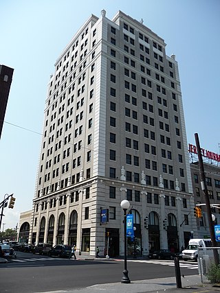
The Journal Square Transportation Center is a multi-modal transportation hub located on Magnolia Avenue and Kennedy Boulevard at Journal Square in Jersey City, New Jersey, United States. Owned and operated by the Port Authority of New York and New Jersey, the complex includes a ten-story tower, a retail plaza, a bus terminal, a two-level parking facility, and the Journal Square station of the PATH rail transit system. The underground station has a high ceiling and a mezzanine level connecting the platforms.
Journal Square is a business district, residential area, and transportation hub in Jersey City, New Jersey, which takes its name from the newspaper Jersey Journal whose headquarters were located there from 1911 to 2013. The "square" itself is at the intersection of Kennedy Boulevard and Bergen Avenue. The broader area extends to and includes Bergen Square, McGinley Square, India Square, the Five Corners and parts of the Marion Section. Many local, state, and federal agencies serving Hudson County maintain offices in the district.
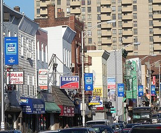
India Square, also known as "Little India," is a commercial and restaurant district in the Journal Square and Marion Section neighborhoods of Jersey City, New Jersey. The area is home to the highest concentration of Indian Americans in the Western Hemisphere, and is a rapidly growing Indian New Yorker ethnic enclave within the New York Metropolitan Area. The neighborhood is centered on Newark Avenue, between Tonnele Avenue and JFK Boulevard, and is considered to be part of the larger Journal Square District. This area has been home to the largest outdoor Navratri festivities in New Jersey as well as several Hindu temples. This portion of Newark Avenue is lined with grocery stores including Patel Brothers and Subzi Mandi Cash & Carry, electronics vendors, video stores, clothing stores, and restaurants, and is one of the busiest pedestrian areas of this part of the city, often stopping traffic for hours. According to the 2000 census, there were nearly 13,000 Indians living in this two-block stretch in Jersey City, up from 3,000 in 1980, increasing commensurately between 2000 and 2010. As of the 2010 Census, over 27,000 Asian Indians accounted for 10.9% of Jersey City's population, the highest proportion of any major U.S. city. After dark, the businesses light flashing signs and the street crowds continue.

The Heights or Jersey City Heights is a neighborhood in Jersey City, New Jersey, located atop the New Jersey Palisades, along the west side of the Hudson River. It is bound by Paterson Plank Road on the north, Highway 139 on the south, Hoboken on the east, and the Hackensack River on the west. and Penhorn Creek on the west. Its postal area ZIP codes are 07307, and portions of 07306.

The Hackensack Plank Road, also known as Bergen Turnpike, was a major artery which connected the cities of Hoboken and Hackensack, New Jersey. Like its cousin routes, the Newark Plank Road and Paterson Plank Road, it travelled over Bergen Hill and across the Hackensack Meadows from the Hudson River waterfront to the city for which it was named. It was originally built as a colonial turnpike road as Hackensack and Hoboken Turnpike. The route mostly still exists today, though some segments are now called the Bergen Turnpike. It was during the 19th century that plank roads were developed, often by private companies which charged a toll. As the name suggests, wooden boards were laid on a roadbed in order to prevent horse-drawn carriages and wagons from sinking into softer ground on the portions of the road that passed through wetlands. The company that built the road received its charter on November 30, 1802. The road followed the route road from Hackensack to Communipaw that was described in 1679 as a "fine broad wagon-road."

Bergen Hill refers to the lower Hudson Palisades in New Jersey, where they emerge on Bergen Neck, which in turn is the peninsula between the Hackensack and Hudson Rivers, and their bays. In Hudson County, it reaches a height of 260 feet.

Bergen Square, at the intersection of Bergen Avenue and Academy Street in Jersey City, is in the southwestern part of the much larger Journal Square district. A commercial residential area, it contains an eclectic array of architectural styles including 19th-century row houses, Art Deco retail and office buildings, and is the site of the longest continually-used school site in the United States. Nearby are the Van Wagenen House and Old Bergen Church, two structures from the colonial period. St. George & St. Shenouda Coptic Orthodox Church founded by early Egyptian immigrants was one of the original Coptic congregations in New Jersey.

The Village is a neighborhood in the western section of Historic Downtown in Jersey City. It is bordered by Hamilton Park and Harsimus Cove to the east and the Turnpike Extension to the west, on the other side of which Jones Park and Mary Benson Park are located. Newark Avenue is the major street across the Village from Grove Street at the east to Bergen Hill at the west. The neighborhood for many years was considered the city's "Little Italy" neighborhood. Brunswick Street, between 1st and 10th Streets was once full of merchants and nicknamed "Bushel Avenue". St. Anthony of Padua Roman Catholic Church at 457 Monmouth St. received its historic designation on March 22, 2004.
Curries Woods is a neighborhood in the southern part of Greenville in Jersey City, New Jersey bordering Bayonne. It was named after James Curie, who was on the town Committee for Greenville when it was its own Township in the 19th century. The area remained rural until the later part of the century when the Central Railroad of New Jersey built a line connecting ferries to Elizabeth, New Jersey and New York City. Currie's Woods still remained untouched through the late part of the century and it was valued for its woods, rocky shore and dunes on Newark Bay. A lot of the land was eventually lost, but a tract was set aside in the early part of the 20th century. A small cemetery, the Old Greenville Cemetery, was nearby. This park lost much of its land to the city's largest Housing Authority project in 1959, except a small tract in Bayonne, Mercer Park.
Bergen-Lafayette is a section of Jersey City, New Jersey.

The West Side of Jersey City is an area made up of several diverse neighborhoods on either side of West Side Avenue, one of the city's main shopping streets. Parallel and west of Kennedy Boulevard, West Side Avenue carries two county route designations.

Country Village is a residential enclave in the southwestern corner of the Greenville section on the West Side of Jersey City, New Jersey that was built as planned community in the early 1960s.

Transfer Station is the name of a section of Hudson County, New Jersey, which radiates from the intersection where Paterson Plank Road crosses Summit Avenue at 7th Street. It is near the tripoint where the borders of Jersey City Heights, North Bergen, and Union City intersect, which is a few blocks to the southwest of the station, at the intersection of Secaucus Road and Kennedy Boulevard.

County Route 617 is 4.55 miles (7.32 km) long and follows one street, Summit Avenue along the ridge of the Hudson Palisades in Hudson County, New Jersey. Its southern end is CR 622, or Grand Street, at Communipaw Junction in the Bergen-Lafayette Section of Jersey City. Its northern end is CR 691, 32nd Street, a section of the Bergen Turnpike, in Union City.

Central Avenue is a 12-block-long thoroughfare in the Heights neighborhood of Jersey City, New Jersey, United States. One of 13 shopping districts in the city, it is designated County Route 663 for 1.60-mile (2.57 km) of its length. It originates at the intersection of Summit Avenue and Pavonia Avenue, and runs north, intersecting Newark Avenue one block east of Five Corners to Paterson Plank Road near Transfer Station. The avenue continues north through Union City without the county route designation to 35th Street, two blocks north of Hackensack Plank Road.

The Hilltop is the eastern section of the Journal Square district of Jersey City, New Jersey. The name is a reflection of its location atop Bergen Hill, the southern portion of the Hudson Palisades, on either side of the cut, or excavated ravine, through which the Port Authority Trans Hudson rapid transit system travels, offering some streets views of Downtown Jersey City, the New York Skyline, and the Upper New York Bay.

Bergen Hill is the name given to the emergence of the Hudson Palisades along the Bergen Neck peninsula in Hudson County, New Jersey and the inland neighborhood of Jersey City where they rise from the coastal plain at the Upper New York Bay. The name is taken from the original 17th-century New Netherland settlement of Bergen, which in Dutch means hills.

The Newkirk House, also known as the Summit House, located at 510 Summit Avenue is the oldest surviving structure in Jersey City, New Jersey. The two-story Dutch Colonial building, composed of sandstone, brick, and clapboard dates to 1690.
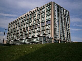
The Hudson County Administration Building is home to the seat of government of Hudson County, New Jersey, US. It is located at 595 Newark Avenue in the Journal Square section of Jersey City in the abutting Five Corners and Hilltop neighborhoods The building houses government administrative offices, the hall of records, and courts for the county and state. Opened in 1957 and expanded in 1966, the International Style structure is considered obsolete and under consideration for replacement, while being demolished once a new courthouse is built.


