Curries Woods

Last updated

Curries Woods is a neighborhood in the southern part of Greenville in Jersey City, New Jersey bordering Bayonne. It was named after James Curie, who was on the town Committee for Greenville when it was its own Township in the 19th century. The area remained rural until the later part of the century when the Central Railroad of New Jersey built a line connecting ferries to Elizabeth, New Jersey and New York City. Currie's Woods still remained untouched through the late part of the century and it was valued for its woods, rocky shore and dunes on Newark Bay. A lot of the land was eventually lost, but a tract was set aside in the early part of the 20th century. A small cemetery, the Old Greenville Cemetery, was nearby. [1] This park lost much of its land to the city's largest Housing Authority project in 1959, except a small tract in Bayonne, Mercer Park. [2] [3]

Contents

Pamrapo

An 1837 map of the peninsula between the Upper New York Bay and the Newark Bay in Hudson County. The map is oriented with North pointing to the right. Pamrepaw is located in the center of the peninsula, between Centreville and Bergen Spire. T18.jpg
An 1837 map of the peninsula between the Upper New York Bay and the Newark Bay in Hudson County. The map is oriented with North pointing to the right. Pamrepaw is located in the center of the peninsula, between Centreville and Bergen Spire.
Pamrapo Avenue near the city line Coach USA Flxible Metro-B 3231.jpg
Pamrapo Avenue near the city line

The area overlapping the city line was earlier called Pamrapo. The name is a derivation of a phrase from the Algonquian language spoken by the Hackensack people, a phratry of the Lenni-Lenape who lived in the northeastern New Jersey at the time of European contact in the 17th century. A possible meaning could be rock or point of rocks which would refer to the terrain [4] [5] [6] [7] [8] and the original ravine in Bergen Hill, or lower Hudson Palisades, found there. Spellings included Pimbrepow, Pembrepock, Pemmerepoch, [9] Pimlipo, Pemrepau, [10] Pemrapaugh, Pamrapough, [11] Pamrepaw [12] and Pamropo. [13] [14] Two streets, one in Greenville and another in northern Bayonne still bear the name. [15] Patents for land Achter Kol (beyond the ridge) were issued in 1654, [16] as an extension of the Pavonia, New Netherland settlement, which were centered on Communipaw and Harsimus. The Pamrapo Bank, founded in Bayonne in the 19th century, takes its name from this area. [17] [18] The Central Railroad of New Jersey maintained a station called Pamrapo along the right of way now used by the Hudson Bergen Light Rail

City line

While the original Lehigh Valley Terminal Railway tracks, New Jersey Route 185, New Jersey Turnpike Newark Bay Extension (I-78) create a physical boundary and de facto border with Bayonne the actual city cuts diagonally across the neighborhood along the route of the Morris Canal. The unusual path of the canal was made necessary by Bergen Hill, lower the Hudson Palisades. Travelling parallel to the base of the ridge it was cut through a natural break in the rock formation, and then travelled northwest to join the Hackensack River, a filled portion still seen in Country Village. [19] [20] [21] [22] [23]

Transportation

Merritt Street,a 0.14 miles (0.23 km) section of which part is designated Hudson County Route 707, is a short street in the neighborhood where Old Bergen Road and Ocean Avenue end and Avenue C begins. [24] The street is terminus for New Jersey Transit Bus 6. [25]

See also

Odonyms in Hudson County, New Jersey

Related Research Articles

<span class="mw-page-title-main">Kill Van Kull</span> Tidal strait between Staten Island, New York and Bayonne, New Jersey, United States

The Kill Van Kull is a tidal strait between Staten Island, New York and Bayonne, New Jersey in the United States. It is approximately 3 miles (4.8 km) long and 1,000 feet (305 m) wide and connects Newark Bay with Upper New York Bay. The Robbins Reef Light is at the eastern end of the Kill, and Bergen Point marks its western end. It is spanned by the Bayonne Bridge and is one of the most heavily traveled waterways in the Port of New York and New Jersey.

<span class="mw-page-title-main">Newark Bay</span> Estuary on the coast of New Jersey, United States

Newark Bay is a tidal bay at the confluence of the Passaic and Hackensack Rivers in northeastern New Jersey. It is home to the Port Newark-Elizabeth Marine Terminal, the largest container shipping facility in Port of New York and New Jersey, the second busiest in the United States. An estuary, it is periodically dredged to accommodate seafaring ships.

<span class="mw-page-title-main">Greenville, Jersey City</span> Populated place in Hudson County, New Jersey, US

Greenville is the southernmost section of Jersey City in Hudson County, in the U.S. state of New Jersey.

Paterson Plank Road is a road that runs through Passaic, Bergen and Hudson Counties in northeastern New Jersey. The route, originally laid in the colonial era, connects the city of Paterson and the Hudson River waterfront. It has largely been superseded by Route 3, but in the many towns it passes it has remained an important local thoroughfare, and in some cases been renamed.

<span class="mw-page-title-main">Bergen Point</span> Populated place in Hudson County, New Jersey, US

Bergen Point is a point of land that lends its name to the adjacent neighborhood in Bayonne in Hudson County, in the U.S. state of New Jersey. The point is located on the north side of Kill van Kull at Newark Bay. It is the section of the city closest to the Bayonne Bridge. Historically the term has been used more broadly as synonymous with Constable Hook, from which it is geographically separated at Port Johnson.

The Newark Plank Road was a major artery between Hudson Waterfront at Paulus Hook and city of Newark further inland across the New Jersey Meadows. As its name suggests, a plank road was constructed of wooden planks laid side-to-side on a roadbed. Similar roads, the Bergen Point Plank Road, the Hackensack Plank Road and Paterson Plank Road, traveled to the locales for which they are named. The name is no longer used, the route having been absorbed into other streets and freeways.

<span class="mw-page-title-main">Gateway Region</span> Urbanized area of northeastern New Jersey, US

The Gateway Region is the primary urbanized area of the northeastern section of New Jersey. It is anchored by Newark, the state's most populous city. It is part of the New York metropolitan area.

<span class="mw-page-title-main">Bergen Hill</span> Lower part of the Hudson Palisades, New Jersey, United States

Bergen Hill refers to the lower Hudson Palisades in New Jersey, where they emerge on Bergen Neck, which in turn is the peninsula between the Hackensack and Hudson Rivers, and their bays. In Hudson County, it reaches a height of 260 feet.

<span class="mw-page-title-main">Bergen Neck</span> Peninsula in northeastern New Jersey, United States

Bergen Neck is the peninsula between the Upper New York Bay and the Newark Bay in the Hudson County, New Jersey municipalities of Bayonne and Jersey City. Its southernmost tip, Bergen Point, is separated from Staten Island by the Kill van Kull, which is crossed by the Bayonne Bridge.

<span class="mw-page-title-main">West Side, Jersey City</span> Populated place in Hudson County, New Jersey, US

The West Side of Jersey City is an area made up of several diverse neighborhoods on either side of West Side Avenue, one of the city's main shopping streets. Parallel and west of Kennedy Boulevard, West Side Avenue carries two county route designations.

<span class="mw-page-title-main">Country Village, Jersey City</span> Populated place in Hudson County, New Jersey, US

Country Village is a residential enclave in the southwestern corner of the Greenville section on the West Side of Jersey City, New Jersey that was built as planned community in the early 1960s.

<span class="mw-page-title-main">Hudson Waterfront</span> Place in Hudson and Bergen

The Hudson Waterfront is an urban area of northeastern New Jersey along the lower reaches of the Hudson River, the Upper New York Bay and the Kill van Kull. Though the term can specifically mean the shoreline, it is often used to mean the contiguous urban area between the Bayonne Bridge and the George Washington Bridge that is approximately 19 miles (31 km) long. Historically, the region has been known as Bergen Neck, the lower peninsula, and Bergen Hill, lower Hudson Palisades. It has sometimes been called the Gold Coast.

<span class="mw-page-title-main">Bergenwood, North Bergen</span> Populated place in Hudson County, New Jersey, US

Bergenwood is a long narrow district of North Bergen, New Jersey in the northern central part of the township between Kennedy Boulevard and Tonnelle Avenue, characterized by the steep slopes on the west side of the Hudson Palisades as they descend to the New Jersey Meadowlands.

<span class="mw-page-title-main">Port Jersey</span> Freight terminal on Upper New York Bay

Port Jersey, officially the Port Jersey Port Authority Marine Terminal and referred to as the Port Jersey Marine Terminal, is an intermodal freight transport facility that includes a container terminal located on the Upper New York Bay in the Port of New York and New Jersey. The municipal border of the Hudson County cities of Jersey City and Bayonne runs along the long pier extending into the bay.

<span class="mw-page-title-main">Summit Avenue (Hudson Palisades)</span> Road in Hudson County, New Jersey, US

County Route 617 is 4.55-mile (7.32 km) long and follows one street, Summit Avenue along the ridge of the Hudson Palisades in Hudson County, New Jersey. Its southern end is CR 622, or Grand Street, at Communipaw Junction in the Bergen-Lafayette Section of Jersey City. Its northern end is CR 691, 32nd Street, a section of the Bergen Turnpike, in Union City.

<span class="mw-page-title-main">Central Avenue (Hudson Palisades)</span> Populated place in Hudson County, New Jersey, US

Central Avenue is a 12-block-long thoroughfare in the Heights neighborhood of Jersey City, New Jersey, United States. One of 13 shopping districts in the city, it is designated County Route 663 for 1.60-mile (2.57 km) of its length. It originates at the intersection of Summit Avenue and Pavonia Avenue, and runs north, intersecting Newark Avenue one block east of Five Corners to Paterson Plank Road near Transfer Station. The avenue continues north through Union City without the county route designation to 35th Street, two blocks north of Hackensack Plank Road.

<span class="mw-page-title-main">Danforth Avenue station</span> Light rail station in Bayonne, New Jersey

Danforth Avenue station is a station on the Hudson–Bergen Light Rail (HBLR) in Jersey City, New Jersey. The station is located at the intersection of Danforth Avenue and Princeton Avenue in Greenville.

<span class="mw-page-title-main">Bergen Point Plank Road</span>

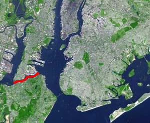
The Jersey City and Bergen Point Plank Road was a road originally built in the 19th century in Hudson County, New Jersey, United States which ran between Paulus Hook and Bergen Point. The company that built the road received a charter on March 6, 1850 to improve one that had been built in the 18th century. It has subsequently become Grand Street and Garfield Avenue in Jersey City and Broadway in Bayonne. Plank roads were built during the 19th century, often by private companies as turnpike roads, in this case with a tollgate at Communipaw Junction. As the name suggests, wooden boards were laid on a roadbed in order to prevent horse-drawn carriages and wagons from sinking into softer ground on the portions of the road.

<span class="mw-page-title-main">Bergen Hill, Jersey City</span> Populated place in Hudson County, New Jersey, US

Bergen Hill is the name given to the emergence of the Hudson Palisades along the Bergen Neck peninsula in Hudson County, New Jersey and the inland neighborhood of Jersey City, New Jersey, where they rise from the coastal plain at the Upper New York Bay. The name is taken from the original 17th-century New Netherland settlement of Bergen, which in Dutch means hills.

References

  1. http://files.usgwarchives.net/nj/hudson/cemeteries/oldgreenville.txt [ bare URL plain text file ]
  2. Curries Woods Archived 2009-01-10 at the Wayback Machine
  3. JC Housding Authority
  4. "Woodlands Indians forums". Archived from the original on October 5, 2011. Retrieved September 13, 2009.
  5. "Pamrapo". Archived from the original on August 11, 2009. Retrieved August 21, 2009.
  6. Timeline for the Founding and History of the City of Bayonne Archived September 17, 2011, at the Wayback Machine , Bayonne Historical Society. Retrieved August 14, 2009.
  7. "GREAT RAILROADS AT WAR Fighting to Secure Lands on Jersey Shore" (PDF). New York Times. December 15, 1889. Retrieved November 16, 2010.
  8. "The Point Of Rocks Line; More About The Little Railroad. Denying That The Work Is To Be Done In The Interest Of The Pennsylvania Road--Plans Of The National Storage Company" (PDF). The New York Times. September 8, 1879.
  9. "RootsWeb: Dutch-Colonies-L [D-Col] Re: Vrouwtie and Gerrtie Gerrits". Archived from the original on March 18, 2012. Retrieved August 21, 2009.
  10. Seven Settled Towns Archived March 27, 2009, at the Wayback Machine
  11. USA archives Bergen deeds Archived 2009-10-20 at the Wayback Machine
  12. United States Coast Guard Survey: New York Bay and Harbor and Environs, Washington, D.C., 1844-45
  13. Currier and Ives, 1872
  14. Gordon, Thomas Francis (1834). "A Gazetteer of the State of New Jersey: Comprehending a General View of Its Physical and Moral Condition, Together with a Topographical and Statistical Account of Its Counties, Towns, Villages, Canals, Rail Roads, &c., Accompanied by a Map".
  15. Hudson County New Jersey Street Map. Hagstrom Map Company, Inc. 2008. ISBN   978-0-88097-763-0.
  16. History of new Netherland, E.B. Callaghan (c)1855
  17. Pamrapo Bank
  18. Timeline for the Founding and History of the City of Bayonne Archived September 17, 2011, at the Wayback Machine
  19. Hudson County New Jersey Street Map. Hagstrom Map Company, Inc. 2008. ISBN   978-0-88097-763-0.
  20. JC Online:Morris Canal
  21. Old Bergen Road
  22. Wikimapia:Newark Bay at Jersey City
  23. http://www.owners.com/NJ/Bayonne/ Archived 2010-04-16 at the Wayback Machine Map of Bayonne
  24. "Hudson County 707 straight line diagram" (PDF). New Jersey Department of Transportation . Retrieved August 20, 2009.
  25. "NJ Transit #6 bus schedule" (PDF). Archived from the original (PDF) on March 28, 2018. Retrieved August 20, 2009.

40°41′21″N74°05′44″W / 40.68903°N 74.09557°W / 40.68903; -74.09557