New Dorp is a neighborhood on the East Shore of Staten Island, New York City, United States. New Dorp is bounded by Mill Road on the southeast, Tysens Lane on the southwest, Amboy and Richmond Roads on the northwest, and Bancroft Avenue on the northeast. It is adjacent to Oakwood to the southwest, Todt Hill to the northwest, Dongan Hills and Grant City, and Midland Beach and Miller Field to the southeast. New Dorp Beach, bordering to the east, is often listed on maps as a separate neighborhood from Mill Road to the shore of Lower New York Bay, but is generally considered to be a part of New Dorp.

The South Shore is a geographical term applied to the area in the New York City borough of Staten Island, south and east of the island's ridge of hills along the waterfront and adjacent areas from the Narrows to the mouth of the Arthur Kill. Many observers prefer to restrict its scope to the neighborhoods located between the shoreline of Raritan Bay on one side and Richmond Creek and Fresh Kills on the other, thus encompassing the neighborhoods of Great Kills to Tottenville only. Those who use this narrower definition of the "South Shore" prefer the term "East Shore" for the communities that lie along Lower New York Bay, and inland for approximately 2 to 2½ miles, from Bay Terrace and Richmondtown to as far north as Grasmere and Concord. The South Shore is represented in the New York City Council by Joe Borelli.
Arrochar is a neighborhood in northeastern Staten Island in New York City in the United States. It is located directly inland of Fort Wadsworth and South Beach, on the east side of Hylan Boulevard south of the Staten Island Expressway; the community of Grasmere borders it on the west. It is today primarily a neighborhood of one- and two-family homes and small businesses.
Prince's Bay is the name of a neighborhood located on the South Shore of New York City's borough of Staten Island. Prince's Bay is bordered to the north by Huguenot, to the south by the Raritan Bay, and to the west by Pleasant Plains. The neighborhood is represented in the New York State Senate by Andrew Lanza, in the New York State Assembly by Michael Reilly, and in the New York City Council by Joe Borelli.

The term East Shore is frequently applied to a series of neighborhoods along the Lower New York Bay and the Raritan Bay and within New York City's borough of Staten Island.

South Beach is a neighborhood on the East Shore of Staten Island, New York City, situated directly south of the Verrazzano-Narrows Bridge. South Beach is bounded by New York Bay on the southeast, Seaview Avenue on the southwest, Laconia Avenue on the northwest, Reid and McClean Avenues on the north, and Lily Pond Avenue on the northeast. It is adjacent to Midland Beach to the southwest, Dongan Hills and Old Town/Concord to the northwest, and Fort Wadsworth and Rosebank to the northeast.

Oakwood is a neighborhood located in east central Staten Island, New York City, near the South Shore. It is bordered by Tysens Lane (north); the Atlantic Ocean (east); Great Kills Park (south); Kensico Street and Clarke Avenue (west).

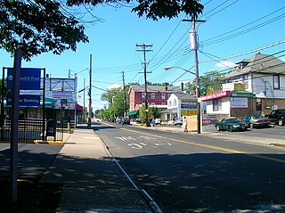
Dongan Hills is a neighborhood located within the New York City borough of Staten Island. It is on the Island's East Shore. Dongan Hills is bounded by Laconia Avenue on the southeast, Jefferson Avenue on the southwest, Richmond Road on the northwest, and Old Town Road to the north. It is adjacent to New Dorp and Grant City to the southwest, Todt Hill to the northwest, Old Town/Concord to the northeast, and South Beach and Midland Beach to the southeast.

Eltingville is a neighborhood in the Staten Island borough of New York City, United States. It is located on Staten Island's South Shore, immediately to the south of Great Kills and north of Annadale. The main commercial area of Eltingville extends down Richmond Avenue, with offshoots heading north on Amboy Road and Hylan Boulevard. Eltingville is represented in the New York State Senate by Andrew Lanza, in the New York State Assembly by Michael Reilly, and in the New York City Council by Joe Borelli.
Huguenot is a neighborhood on the South Shore of Staten Island, New York City. Originally named "Bloomingview", it was later named for the Huguenots, led by Daniel Perrin, who settled in the area during the late 17th and early 18th centuries to escape religious persecution. Huguenot is bordered by Arden Heights to the north, Woodrow to the west, Prince's Bay to the south, and Annadale to the east. The neighborhood is represented in the New York City Council by Joe Borelli, who was born and raised there. Huguenot is represented in the New York State Senate by Andrew Lanza and in the New York State Assembly by Michael Reilly
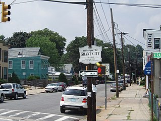
Grant City is the name of a neighborhood located on the East Shore of Staten Island, New York City.

Grasmere is the name of a neighborhood located on the East Shore of Staten Island, one of the five boroughs of New York City.

Concord is a neighborhood located in the borough of Staten Island in New York City, New York, United States.

Eltingville Transit Center is a park and ride transit center that is located in Eltingville, Staten Island. It is located at the intersection of Arthur Kill Road and Richmond Avenue, at the end of the Korean War Veterans Parkway. The transit center was completed in 2004. Amenities include schedules, maps, free parking, and vending machines for soda, snacks, and MetroCards. The center is halfway between the Eltingville Staten Island Railway station and the Staten Island Mall, another transit center, including the adjacent Yukon Depot.

James Steven Oddo is a Republican politician from Staten Island, currently serving as the Borough President of Staten Island.

Richmond Avenue is a major north-south thoroughfare on Staten Island, New York. Measuring approximately 7.0 miles (11.3 km), the road runs from the South Shore community of Eltingville to the North Shore community of Graniteville.
Hylan Boulevard is a major northeast-southwest boulevard in the New York City borough of Staten Island, and the longest street in the city. It is approximately 14 miles (23 km) long, and runs from the North Shore neighborhood of Rosebank, then along the entire East Shore, to the South Shore neighborhood of Tottenville. It was renamed in 1923 for New York City mayor John F. Hylan, before which it was known as Southfield Boulevard and the northern segment as Pennsylvania Avenue. It is often misunderstood to be read as Hyland or Highland Boulevard.

The Olmsted-Beil House was a large farm and modest Dutch farmhouse at 4515 Hylan Boulevard in the South Shore of Staten Island, New York City. The house was purchased by Olmsted's father and given to Frederick Law Olmsted in 1848 to grow crops, plant trees and clear for pasture for livestock. It is on one of the higher hills overlooking Raritan Bay, and Sandy Hook in New Jersey.
Richmond Road is a major north-south artery along the East Shore of the New York City borough of Staten Island. It is approximately 4.93 miles (7.93 km) long, and runs through the neighborhoods of Concord, Grymes Hill, Emerson Hill, Grasmere, Old Town, Dongan Hills, Grant City, Todt Hill, New Dorp, Egbertville, Lighthouse Hill, and Richmondtown.

