
St. George is a neighborhood on the northeastern tip of Staten Island in New York City, along the waterfront where the Kill Van Kull enters Upper New York Bay. It is the most densely developed neighborhood on Staten Island, and the location of the administrative center for the borough and for the coterminous Richmond County. The St. George Terminal, serving the Staten Island Ferry and the Staten Island Railway, is also located here. St. George is bordered on the south by the neighborhood of Tompkinsville and on the west by the neighborhood of New Brighton.

Stapleton is a neighborhood in northeastern Staten Island in New York City in the United States. It is located along the waterfront of Upper New York Bay, roughly bounded on the north by Tompkinsville at Grant Street, on the south by Clifton at Vanderbilt Avenue, and on the west by St. Paul's Avenue and Van Duzer Street, which form the border with the community of Grymes Hill.

Port Richmond is a neighborhood situated on the North Shore of Staten Island, a borough of New York City. Port Richmond is bounded by Kill van Kull on the north, Jewett Avenue on the east, Forest Avenue on the south, and the Bayonne Bridge on the west. It is adjacent to West New Brighton to the east, Westerleigh to the south, and Elm Park and Mariners Harbor to the west.

New Brighton is a neighborhood located on the North Shore of Staten Island in New York City. The neighborhood comprises an older industrial and residential harbor front area along the Kill Van Kull west of St. George. New Brighton is bounded by Kill Van Kull on the north, Jersey Street on the east, Brighton and Castleton Avenues to the south, and Lafayette Avenue and Snug Harbor Cultural Center to the west. It is adjacent to St. George to the east, Tompkinsville to the south, and West New Brighton to the west.

West New Brighton is a neighborhood of Staten Island, New York City, situated along the central North Shore. The neighborhood is bordered by New Brighton to the east, Port Richmond to the west, the waters of the Kill Van Kull to the north, and the communities of Sunnyside and Castleton Corners to the south.
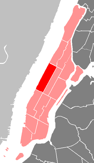
The Manhattan Community Board 7 is a New York City community board encompassing the neighborhoods of Manhattan Valley, Upper West Side, and Lincoln Square in the borough of Manhattan.
The Queens Community Board 1 is a local advisory group in New York City, encompassing the neighborhoods of Astoria, Long Island City, Queensbridge, Ditmars, Ravenswood, Steinway, Garden Bay, and Woodside, in the Borough of Queens. It also includes Rikers Island, the citywide correctional complex, which is within the Borough of the Bronx but connected by its only bridge to Astoria. The Board's district is delimited by the East River on both west and north, by the Brooklyn–Queens Expressway on the east, and by Northern Boulevard, the Long Island Rail Road and Bridge Plaza North on the south.
The borough president is an elected office in each of the five Boroughs of New York City. For most of the city's history, the office exercised significant executive powers within each borough, and the five borough presidents also sat on the New York City Board of Estimate. Since 1990, the borough presidents have been stripped of a majority of their powers in the government of New York City.

Bronx Community Board 7 the governing body of Bronx Community District 7, a local government unit of the city of New York. The Community District encompasses the neighborhoods of Bedford Park, Fordham, Jerome Park, Kingsbridge Heights, Norwood, and University Heights. It is delimited by the New York-New Haven Railroad, Webster Avenue, East Fordham Road, Jerome Avenue, and West 183rd Street to the east, Jerome Avenue, West Gun Hill Road, Goulden Avenue, Kingsbridge Road, West 225th Street, and the Harlem River to the west, West Gun Hill Road, Jerome Avenue, Bainbridge Avenue, and East 211th Street to the north and Hall of Fame Terrace to the south.

Bronx Community Board 10 is a local government unit of the New York City borough of the Bronx, encompassing the neighborhoods of City Island, Co-op City, Pelham Bay, Throggs Neck and Westchester Square. It is delimited by the Hutchinson River and Pelham Bay Park to the east, New England Thruway, Hutchinson River Parkway, and Westchester Creek to the west, the Bronx/Westchester County Line to the north and the East River to the south.

Community boards of Manhattan are New York City community boards in the borough of Manhattan, which are the appointed advisory groups of the community districts that advise on land use and zoning, participate in the city budget process, and address service delivery in their district.
The Queens Community Board 2 is a local advisory group in New York City, encompassing the neighborhoods of Hunters Point, Long Island City, Sunnyside, and Woodside, in the borough of Queens. It is delimited by the East River on the west; Bridge Plaza North, the Long Island Rail Road and Northern Boulevard on the north; New York Connecting Railroad on the east; and Newtown Creek on the south.
Community boards of Queens are New York City community boards in the borough of Queens, which are the appointed advisory groups of the community districts that advise on land use and zoning, participate in the city budget process, and address service delivery in their district.
Community boards of the Bronx are the 12 New York City community boards in the borough of the Bronx, which are the appointed advisory groups of the community districts that advise on land use and zoning, participate in the city budget process, and address service delivery in their district.
Community boards of Staten Island are New York City community boards in the borough of Staten Island, which are the appointed advisory groups of the community districts that advise on land use and zoning, participate in the city budget process, and address service delivery in their district.

Staten Island Community Board 2 is a local government unit of the city of New York, encompassing the Staten Island neighborhoods of Arrochar, Bloomfield, Bulls Head, Chelsea, southern Castleton Corners, Dongan Hills, Egbertville, Emerson Hill, southern Graniteville, Grant City, Grasmere, Heartland Village, Midland Beach, New Dorp, New Springville, Oakwood, Ocean Breeze, Old Town, South Beach, Todt Hill, Travis, and southern Willowbrook.

Staten Island Community Board 3 is a local government unit of the city of New York, encompassing the Staten Island neighborhoods of Annadale, Arden Heights, Bay Terrace, Charleston, Eltingville, Great Kills, Greenridge, Huguenot, Pleasant Plains, Prince's Bay, Richmond Valley, Rossville, Tottenville and Woodrow.
The community boards of the New York City government are the appointed advisory groups of the community districts of the five boroughs. There are currently 59 community districts: twelve in the Bronx, eighteen in Brooklyn, twelve in Manhattan, fourteen in Queens, and three in Staten Island.

New York City's 49th City Council district is one of 51 districts in the New York City Council. It has been represented by Democrat Kamillah Hanks since 2022. Hanks succeeded former councilwoman Debi Rose, who was term limited in 2021.

New York City's 50th City Council district is one of 51 districts in the New York City Council. It has been represented by Republican David Carr since the end of 2021. Carr was the chief of staff to former Councilman Steven Matteo. Matteo was term-limited in 2021 and ran unsuccessfully for Staten Island Borough President.


