Long Island City (LIC) is a residential and commercial neighborhood on the extreme western tip of Queens, a borough in New York City. It is bordered by Astoria to the north; the East River to the west; New Calvary Cemetery in Sunnyside to the east; and Newtown Creek—which separates Queens from Greenpoint, Brooklyn—to the south.
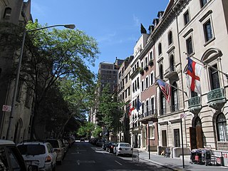
The Upper East Side, sometimes abbreviated UES, is a neighborhood in the borough of Manhattan in New York City, bounded by 96th Street to the north, the East River to the east, 59th Street to the south, and Central Park/Fifth Avenue to the west. The area incorporates several smaller neighborhoods, including Lenox Hill, Carnegie Hill, and Yorkville. Once known as the Silk Stocking District, it has long been the most affluent neighborhood in New York City.

The Manhattan Community Board 3 is a New York City community board encompassing the Manhattan neighborhoods of Alphabet City, the East Village, the Lower East Side, Two Bridges, and a large portion of Chinatown. It is delimited by the East River on the east, the Brooklyn Bridge on the south, Pearl Street, Baxter Street, Canal Street, Bowery and Fourth Avenue on the west, as well as by the 14th Street on the north.
The Manhattan Community Board 2 is a New York City community board encompassing the neighborhoods of Greenwich Village, West Village, South Village, NoHo, SoHo, Little Italy, NoLIta, and a portion of Chinatown in the borough of Manhattan. It is bounded by the Bowery, Canal Street, the Hudson River, and 14th Street on the east, south, west, and north, respectively. The district covers three city council districts and four police precincts, and encompasses one of the largest landmark districts in New York City.

The Manhattan Community Board 1 is a New York City community board encompassing the neighborhoods of Battery Park City, the Financial District, the South Street Seaport, and TriBeCa in Lower Manhattan in the borough of Manhattan as well as Liberty Island, Ellis Island and Governors Island. It is bounded by Baxter Street, Pearl Street, the Brooklyn Bridge and the East River on the east, Upper New York Bay on the south, the Hudson River on the west and Canal Street on the north.

The Manhattan Community Board 4 is a New York City community board in the borough of Manhattan encompassing the neighborhoods of Hell's Kitchen, Chelsea, and Hudson Yards, as well as parts of the Garment District, the Flower District, and the Meatpacking District. It is delimited by the Avenue of the Americas, 26th Street, and Eighth Avenue on the east, 14th Street on the south, the Hudson River on the west, and 59th Street on the north.
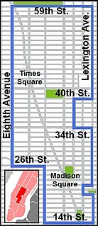
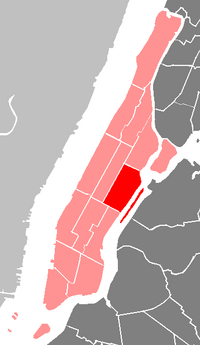
Manhattan Community Board 5 is a New York City community board, part of the local government apparatus of the city, with the responsibility for the neighborhoods of Midtown, Times Square, most of the Theater District, the Diamond District, the Garment District, Herald Square, Koreatown, NoMad, Murray Hill and the Flatiron District, all in the borough of Manhattan. It is bounded by 59th Street on the north, Eighth Avenue, 26th Street, the Avenue of the Americas on the west, 14th Street on the south, and Lexington Avenue on the east, excluding the area from 34th to 40th Streets between Madison and Lexington Avenues, and the area from 20th to 22nd Streets between Park Avenue South and Lexington Avenue/Irving Place.

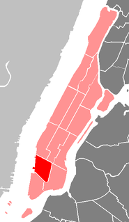
Manhattan Community Board 6 is a New York City community board, part of the local government apparatus of the city, with responsibility for the East Side of Manhattan from 14th Street to 59th Street. This includes the neighborhoods of Gramercy Park, Stuyvesant Park, Stuyvesant Town, Peter Cooper Village, Rose Hill, Waterside Plaza, Murray Hill, Kips Bay, Turtle Bay, Tudor City, and Sutton Place. The eastern and western borders are the East River and Lexington Avenue, except between 34th Street and 40th Street, where the area extends west to Madison Avenue, and between 20th Street and 22nd Street where it extends west to Park Avenue South.

The Manhattan Community Board 7 is a New York City community board encompassing the neighborhoods of Manhattan Valley, Upper West Side, and Lincoln Square in the borough of Manhattan.

The Manhattan Community Board 9 is a New York City community board encompassing the neighborhoods of Hamilton Heights, Manhattanville, and Morningside Heights in the borough of Manhattan. It is delimited by Edgecombe Avenue, Bradhurst Avenue, Saint Nicholas Avenue, the 123rd Street and Morningside Avenue on the east, Cathedral Parkway on the south, the Hudson River on the west and 155th Street on the north.

The Manhattan Community Board 10 is a New York City community board encompassing the neighborhoods of Harlem and Polo Grounds in the borough of Manhattan. It is delimited by Fifth Avenue and Mount Morris Park on the east, Central Park on the south, Harlem River drive, Edgecombe Avenue, Saint Nicholas Avenue, the 123rd street and Morningside Avenue on the west, as well as by the Harlem River on the north.

The Manhattan Community Board 11 is a New York City community board encompassing the Manhattan neighborhoods of East Harlem and Randalls Island. It is delimited by the East River on the east, 96th Street on the south, Fifth Avenue and Mount Morris Park on the west, as well as by the Harlem River on the north. It also includes Ward Island Park and Randall Island Park.

The Manhattan Community Board 12 is a New York City community board for the neighborhoods of Inwood and Washington Heights in the borough of Manhattan. It is delimited by the Harlem River on the east and on the north, the Hudson River on the west and 155th Street on the south.
Brooklyn Community Board 6 is a New York City community board that encompasses the Brooklyn neighborhoods of Red Hook, Carroll Gardens, Park Slope, Gowanus, Cobble Hill and Columbia Street Waterfront District. It is delimited by Upper New York Bay and East River on the west, Atlantic Avenue, Court Street, Fourth Avenue, Warren and Pacific Streets on the north, Prospect Park on the east, as well as by the 15th Street, Hamilton Avenue and the Gowanus Canal on the south. It approximates the 19th century district of South Brooklyn.

Brooklyn Community Board 10 is a New York City community board that encompasses the Brooklyn neighborhoods of Bay Ridge, Dyker Heights, and Fort Hamilton. It is delimited by Upper New York Bay on the west, Bay Ridge R.R. Yards and Long Island Rail Road on the north, 14th Avenue and Bay 8th Street on the east, as well as by Lower New York Bay on the south.
Brooklyn Community Board 13 is a New York City community board that encompasses the Brooklyn neighborhoods of Coney Island, Brighton Beach, Bensonhurst, Gravesend, and Seagate. It is delimited by Gravesend Bay on the west, 26th Avenue, 86th Street, Avenue Y on the north, Coney Island Avenue and Corbin Place on the east, as well as by Lower New York Bay on the south.
Brooklyn Community Board 15 is a New York City community board that encompasses the Brooklyn neighborhoods of Gravesend, Sheepshead Bay, Manhattan Beach, Gerritsen Beach, Madison, Homecrest, and Plum Beach. It is delimited by Corbin Place, Coney Island Avenue, Avenue Y, 86th street, Avenue U and McDonald Avenue, Avenue P and Kings Highway on the north, Nostrand avenue and Marine Park on the east, as well as by the Atlantic Ocean on the south.

Hamilton Heights is a neighborhood in the northern part of Manhattan in New York City. It is the northernmost part of the West Harlem area, along with Manhattanville and Morningside Heights to its south, and it contains the sub-neighborhood and historic district of Sugar Hill. Washington Heights lies to Hamilton Heights' north, and to its east is Central Harlem.

Community boards of Manhattan are New York City community boards in the borough of Manhattan, which are the appointed advisory groups of the community districts that advise on land use and zoning, participate in the city budget process, and address service delivery in their district.

Lenox Hill is a neighborhood on Manhattan's Upper East Side. It forms the lower section of the Upper East Side—east of Park Avenue in the 60s and 70s.