Yorkville, Manhattan

Last updated

Yorkville
Yorkville NYC from 87th St.jpg
Yorkville, as seen from a highrise on East 87th Street
Yorkville, Manhattan
Location in New York City
Coordinates: 40°46′34″N73°57′00″W / 40.776°N 73.950°W / 40.776; -73.950
Country Flag of the United States.svg  United States
State Flag of New York.svg  New York
City New York City
Borough Manhattan
Community District Manhattan 8 [1]
Area
[2]
  Total1.27 km2 (0.492 sq mi)
Population
 (2020) [3]
  Total78,241
  Density61,000/km2 (160,000/sq mi)
Ethnicity
Economics
   Median income $103,234
Time zone UTC−5 (Eastern)
  Summer (DST) UTC−4 (EDT)
ZIP Codes
10028, 10075, 10128
Area codes 212, 332, 646, and 917

Yorkville is a neighborhood on the Upper East Side of Manhattan, New York City, United States. Its southern boundary is East 79th Street, its northern East 96th Street, its western Third Avenue, and its eastern the East River. [4] Yorkville is one of the most densely populated city subdivisions in the world.

Contents

Yorkville is part of Manhattan Community District 8, and its primary ZIP Codes are 10028, 10075, and 10128. [1] It is patrolled by the 19th Precinct of the New York City Police Department.

History

Looking west at 90th Street and Second Avenue Yorkville NYC at 90th Street.jpg
Looking west at 90th Street and Second Avenue

Early history

Pre-colonization, Yorkville was an undeveloped area of forests and streams. In August 1776, George Washington stationed half of his Continental Army in Manhattan and the other half in Brooklyn. Many troops in the Yorkville area on Manhattan's Upper East Side were in defensive positions along the East River to protect a possible retreat off Long Island, and to inflict damage on invading land and sea British forces. [5] Following their August 27 defeat in the Battle of Long Island, the Continentals implemented an orderly pivoting retreat in the Yorkville area, leading the enemy to entice the Continentals to fight by piping "Fly Away", about a fox running away from hounds. The Continentals' disciplined northerly retreat led to the successful Battle of Harlem Heights in September 1776. [6]

In 1815, the Upper East Side was a farmland and market garden district. [7] The Boston Post Road traversed the Upper East Side, locally called the Eastern Post Road; milepost 6 was near the northeast corner of Third Avenue and 81st Street. From 1833 to 1837 the New York and Harlem Railroad, one of the earliest railway systems in the United States, was extended through the Upper East Side along Fourth Avenue (later renamed Park Avenue). [8] A hamlet grew near the 86th Street station, becoming the Yorkville neighborhood as gradual yet steady commercial development occurred. The current street grid was laid-out between 1839 and 1844 as part of the Commissioners' Plan of 1811, so the Eastern Post Road was abandoned. The community had been referred to as Yorkville before 1867. [9]

By 1850, a significant proportion of the inhabitants of the area were the Germans and Irish that helped build the Croton Aqueduct. [10] The area was included in the 19th administrative district, whose boundaries were 40th and 86th Street. [11] In 1858, horsecars began running on Second and Third Avenues. After the American Civil War, mansions replaced slums in Yorkville. [11] On December 30, 1878, the IRT Third Avenue Line opened, followed by the IRT Second Avenue Line in August 1879. [12]

Ethnic settlement

For much of the 19th and into the 20th centuries, Yorkville was a mostly German enclave of middle- to working-class families. Over time, many people of Czech, Slovak, Irish, French Canadian, Polish, Hungarian, and Lebanese descent moved in. [13] The neighborhood became more affluent. [14]

From 1880, Yorkville became a destination for German-born immigrants. However, by the 1900s, many German residents moved to Yorkville and other neighborhoods from "Kleindeutschland" (Little Germany) on the Lower East Side after the General Slocum disaster on June 15, 1904. The ship caught fire in the East River just off the shores of Yorkville, leading family members to move closer to the site of the incident. [15] Most of the passengers on the ship were German. [16] [17] In addition, the general trend towards moving to the suburbs reduced the German population in Manhattan; by 1930, most German New Yorkers lived in Queens.

On 86th Street, in the central portion of Yorkville, there were many German shops, restaurants and bakeries. Yorkville became the melting pot of populations arriving from various regions of the Prussian-dominated German Empire and its colonies, where many cultures spoke German. In the 1930s, the neighborhood was the home base of Fritz Julius Kuhn's German American Bund, the most notorious pro-Nazi group in 1930s United States, which led to spontaneous protests by other residents. [18] Yorkville was a haven for refugees from Nazi Germany in the 1940s, and from refugees from communist regimes in the 1950s and 1960s. The neighborhood is the site of the annual Steuben Parade, a large German-American celebration. [19]

The largest non-German group were the Irish, [20] who mostly lived in an area bounded by 81st and 85th Streets, and Lexington and Fifth Avenues. They attended mass at such churches as St. Ignatius Loyola on 84th Street and Park Avenue, Our Lady of Good Counsel (90th Street) and the Church of St. Joseph (87th Street). There were many Irish bars including Dorrian's Red Hand Restaurant. Until the late 1990s, New York's St. Patrick's Day Parade ended at 86th Street and Third Avenue, the historical center of Yorkville. [21] In addition, Jews also lived on Second Avenue. [12]

79th Street was a hub for the Austro-Hungarian populace. Popular restaurants included the Viennese Lantern, Tokay, Hungarian Gardens, Robert Heller's Cafe Abbazia at 2nd Avenue, Budapest and the Debrecen. [22] There were also a number of butcher stores and businesses that imported goods from Hungary. Churches included St. Stephen Catholic Church and the Hungarian Reformed Church on East 82nd Street. In addition, Czechs, Poles and Slovaks lived from 65th to 73rd Street. Besides Ruc, a Czech restaurant off Second Avenue, Praha on Second Avenue, and Varsata on East 75th, there were sokol halls on 67th and 71st Streets. There were other Czech and Slovak businesses, such as Czech butcher shops, poultry and grocery stores, and shops that sold imported goods such as Bohemian books, leather products and crystal. [22]

Recent history

A sidewalk clock on 1501 Third Avenue Sidewalk clock 1501 Third Avenue from south.jpg
A sidewalk clock on 1501 Third Avenue

Around the late 1920s, Yorkville's ethnic diversity was beginning to wane. In 1926, the New York Times wrote of Yorkville's changing ethnic makeup:

Yorkville, for well-nigh two decades known to connoisseurs of east side life as the exclusive domain of Czechoslovaks, Hungarians and Germans, is slowly giving up its strongly accentuated Central European character and gradually merging into a state of colorless impersonality… [11]

In 1928, a one-block section of Sutton Place north of 59th Street, and all of Avenue A north of that point, was renamed York Avenue to honor U.S. Army Sergeant Alvin York, who received the Medal of Honor for attacking a German machine gun nest during World War I's Meuse-Argonne Offensive. [23] [24] [25]

In March 1936, the German American Bund established its headquarters on East 85th Street in Yorkville. This pro-Nazi anti-Semitic organization organized parades, rallies and summer camps for children and families and worked to keep America out of the war, to the benefit of Germany. Their 1939 rally in Madison Square Garden drew more than 10,000 Nazis and sympathizers. They were forced to disband after Germany declared war on the United States in December 1941. [26] [27] [28]

The dismantling of the Third Avenue El in 1955 led to the demolition of many mansions. This led to the acceleration of the exodus of Yorkville residents. Over the years, this trend continued. Thus, in the 1980s, a building for members of the German gymnastic society Turners, at the intersection of 86th Street and Lexington Avenue, was demolished. Cafe Mozart, on 86th Street between Second and Third Avenues, was also demolished. In their place were built high-rise residential complexes. [12] [22]

By the turn of the 21st century, East 82nd Street was co-named St. Stephen of Hungary Way. The area from East 79th to 83rd Streets, spanning approximately four blocks east-west, is colloquially known as Little Hungary. [29]

Demographics

76th Street between Second and Third Avenues Yorkville, 76th East.jpg
76th Street between Second and Third Avenues

Based on data from the 2010 United States Census, the population of Yorkville was 77,942, an increase of 1,174 (1.5%) from the 76,768 counted in 2000. Covering an area of 319.14 acres (129.15 ha), the neighborhood had a population density of 244.2 inhabitants per acre (156,300/sq mi). [30]

The racial makeup of the neighborhood was 76.0% (59,233) white, 3.7% (2,858) African American, 0.1% (51) Native American, 9.3% (7,226) Asian, 0.0% (25) Pacific Islander, 0.3% (216) from other races, and 1.9% (1,466) from two or more races. Hispanic or Latino of any race were 8.8% (6,867) of the population. [31]

The racial composition of Yorkville changed moderately from 2000 to 2010. The most significant changes were the increase in the Asian population by 41% (2,117), the increase in the Hispanic / Latino population by 18% (1,024), and the decrease in the white population by 4% (2,201). The Black population increased by 2% (64) and remained small, as did the population of all other races, which increased by 11% (170). [32]

The median income for a household in Yorkville is almost twice the average for the city, at $85,724. [33]

Police and crime

Yorkville is patrolled by the 19th Precinct of the NYPD, located at 153 East 67th Street. [34] The 19th Precinct ranked 14th safest out of 69 patrol areas for per-capita crime in 2010. [35] The 19th Precinct has a lower crime rate than in the 1990s, with crimes across all categories having decreased by 82.2% between 1990 and 2022. The precinct reported 2 murders, 12 rapes, 229 robberies, 173 felony assaults, 278 burglaries, 1,724 grand larcenies, and 192 grand larcenies auto in 2022. [36]

Fire safety

Quarters of New York City Fire Department Engine Company 22/Ladder Company 13/Battalion 10 Eng 22 Ladder 13 Bn 10 at 159 E85 St jeh.jpg
Quarters of New York City Fire Department Engine Company 22/Ladder Company 13/Battalion 10

Yorkville is served by two New York City Fire Department (FDNY) fire stations: [37]

Post offices and ZIP Codes

Yorkville is located in three primary ZIP Codes. From south to north, they are 10075 (between 76th and 80th Streets), 10028 (between 80th and 86th Streets), and 10128 (north of 86th Street). In addition, 500 East 77th Street in Yorkville has its own ZIP Code, 10162. [40] The United States Postal Service operates three post offices in Yorkville:

Education

New York Public Library, Yorkville branch NYPL E79 jeh.JPG
New York Public Library, Yorkville branch

Schools and higher education

The New York City Department of Education operates several public schools in the area.

The City University of New York has its administrative offices in Yorkville. [44] In addition Fordham Graduate Housing is located on East 81st Street between York and East End Avenues. [45]

The Lycée Français de New York is located on East 75th Street between York and East End Avenues. Further north, East Side Middle School is located on 91st Street between First and Second Avenues. The Trevor Day School is located four blocks north, on 95th Street between First and Second Avenues.

Libraries

The New York Public Library (NYPL) operates two branches near Yorkville. The Yorkville branch is located at 222 East 79th Street. The branch, a Carnegie library, opened in 1902 and was renovated in 1986–1987. The three-story space is listed on the New York State Register of Historic Places and the National Register of Historic Places. [46] The Webster branch is located at 1465 York Avenue. The branch was founded in 1893 as the Webster Free Library, and the current Carnegie library structure opened in 1906. [47]

Transportation

The New York City Subway's 86th Street and 96th Street stations, served by the Second Avenue Subway ( Q train), serve much of Yorkville. [48] Meanwhile, Western Yorkville is served by 77th Street, 86th Street and 96th Street stations on the IRT Lexington Avenue Line ( 6 and <6> trains), [48] one block west of Yorkville's western boundary at 3rd Avenue. [49] The bus routes M15 , M15 SBS , M31 , M72 , M79 SBS , M86 SBS , M96 , M98 , M101 , M102 , M103 of the New York City Bus also operate in Yorkville. [50]

Formerly, Eastern Yorkville was very far from any subway connections, and had among the farthest walks in Manhattan to any subway stations. [13] From 2007 to 2017, the Metropolitan Transportation Authority built the Second Avenue Subway's 86th Street and 96th Street stations, leading to increased residential construction and real estate prices in advance of the opening of the new subway line. [51]

Yorkville is served by NYC Ferry's Soundview and Astoria routes, which stop at 90th Street. [52] The service started operating on August 15, 2018. [53] [54]

Prominent locations

Carl Schurz Park in summer Carl Schurz Park.jpg
Carl Schurz Park in summer

Notable residents

Residents of Yorkville have included:

Related Research Articles

<span class="mw-page-title-main">Upper West Side</span> Neighborhood of Manhattan in New York City

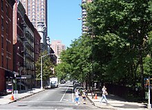
The Upper West Side (UWS) is a neighborhood in the borough of Manhattan in New York City. It is bounded by Central Park on the east, the Hudson River on the west, West 59th Street to the south, and West 110th Street to the north. The Upper West Side is adjacent to the neighborhoods of Hell's Kitchen to the south, Columbus Circle to the southeast, and Morningside Heights to the north.

<span class="mw-page-title-main">Upper East Side</span> Neighborhood of Manhattan in New York City

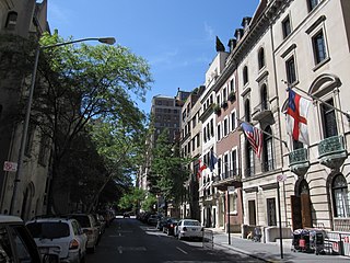
The Upper East Side, sometimes abbreviated UES, is a neighborhood in the borough of Manhattan in New York City, bounded approximately by 96th Street to the north, the East River to the east, 59th Street to the south, and Central Park and Fifth Avenue to the west. The area incorporates several smaller neighborhoods, including Lenox Hill, Carnegie Hill, and Yorkville. Once known as the Silk Stocking District, it has long been the most affluent neighborhood in New York City.

<span class="mw-page-title-main">East Harlem</span> Neighborhood of Manhattan in New York City

East Harlem, also known as Spanish Harlem or El Barrio, is a neighborhood of Upper Manhattan in New York City, north of the Upper East Side and bounded by 96th Street to the south, Fifth Avenue to the west, and the East and Harlem Rivers to the east and north. Despite its name, it is generally not considered to be a part of Harlem proper, but it is one of the neighborhoods included in Greater Harlem.

<span class="mw-page-title-main">Kips Bay, Manhattan</span> Neighborhood of Manhattan in New York City

Kips Bay, or Kip's Bay, is a neighborhood on the east side of the New York City borough of Manhattan. It is roughly bounded by East 34th Street to the north, the East River to the east, East 27th and/or 23rd Streets to the south, and Third Avenue to the west.

<span class="mw-page-title-main">Carnegie Hill</span> Neighborhood of Manhattan in New York City

Carnegie Hill is a neighborhood within the Upper East Side, in the borough of Manhattan in New York City. Its boundaries are 86th Street on the south, Fifth Avenue on the west, with a northern boundary at 98th Street that continues just past Park Avenue and turns south to 96th Street and proceeds east up to, but not including, Third Avenue. The neighborhood is part of Manhattan Community District 8.

<span class="mw-page-title-main">Second Avenue (Manhattan)</span> North-south avenue in Manhattan, New York

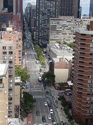
Second Avenue is located on the East Side of the New York City borough of Manhattan extending from Houston Street at its south end to the Harlem River Drive at 128th Street at its north end. A one-way street, vehicular traffic on Second Avenue runs southbound (downtown) only, except for a one-block segment of the avenue in Harlem. South of Houston Street, the roadway continues as Chrystie Street south to Canal Street.

<span class="mw-page-title-main">Wakefield, Bronx</span> Neighborhood of the Bronx in New York City

Wakefield is a working-class and middle-class section of the northern borough of the Bronx in New York City. It is bounded by the city's border with Westchester County to the north, East 222nd Street to the south, and the Bronx River Parkway to the west.

<span class="mw-page-title-main">Hamilton Heights, Manhattan</span> Neighborhood of Manhattan in New York City

Hamilton Heights is a neighborhood in the northern part of Manhattan in New York City. It is the northernmost part of the West Harlem area, along with Manhattanville and Morningside Heights to its south, and it contains the sub-neighborhood and historic district of Sugar Hill. Washington Heights lies to Hamilton Heights' north, and to its east is Central Harlem.

<span class="mw-page-title-main">86th Street (Manhattan)</span> West-east street in Manhattan, New York

86th Street is a major two-way street in the Upper East Side and Upper West Side of the New York City borough of Manhattan. It runs in two major sections: between East End and Fifth Avenue on the Upper East Side, and between Central Park West and Riverside Drive on the Upper West Side. The western segment feeds into the 86th Street transverse across Central Park, which connects to East 84th and 85th Streets on the eastern side.

<span class="mw-page-title-main">Hudson Heights, Manhattan</span> Neighborhood of Manhattan in New York City

Hudson Heights is a residential neighborhood within Washington Heights in Upper Manhattan, New York City. Most residences are apartment buildings, many of which are cooperatives, and most were constructed in the 1920s through 1940s. The Art Deco style is prominent, along with Tudor Revival. Notable complexes include Hudson View Gardens and Castle Village, which were both developed by Dr. Charles V. Paterno, and were designed by George F. Pelham and his son, George F. Pelham, Jr., respectively.

<span class="mw-page-title-main">Manhattanville, Manhattan</span> Neighborhood of Manhattan in New York City

Manhattanville is a neighborhood in the New York City borough of Manhattan bordered on the north by 135th Street; on the south by 122nd and 125th Streets; on the west by Hudson River; and on the east by Adam Clayton Powell Jr. Boulevard and the campus of City College.

<span class="mw-page-title-main">Homecrest, Brooklyn</span> Neighborhood of Brooklyn in New York City

Homecrest is a neighborhood situated in the New York City borough of Brooklyn, sometimes considered as part of Sheepshead Bay. It is bordered by Kings Highway to the north, Avenue X to the south, Coney Island Avenue to the west, and Ocean Avenue to the east.

<span class="mw-page-title-main">Community boards of Manhattan</span>

Community boards of Manhattan are New York City community boards in the borough of Manhattan, which are the appointed advisory groups of the community districts that advise on land use and zoning, participate in the city budget process, and address service delivery in their district.

<span class="mw-page-title-main">85th Street (Manhattan)</span> West-east street in Manhattan, New York

85th Street is a westbound-running street, running from East End Avenue to Riverside Drive in the borough of Manhattan in New York City, United States.

<span class="mw-page-title-main">96th Street (Manhattan)</span> West-east street in Manhattan, New York

96th Street is a major two-way street on the Upper East Side and Upper West Side sections of the New York City borough of Manhattan. It runs in two major sections: between the FDR Drive and Fifth Avenue on the Upper East Side, and between Central Park West and Henry Hudson Parkway on the Upper West Side. The two segments are connected by the 97th Street transverse across Central Park, which links the disconnected segments of 96th and 97th Streets on each side.

<span class="mw-page-title-main">Lenox Hill</span> Neighborhood of Manhattan in New York City

Lenox Hill is a neighborhood on the Upper East Side of Manhattan in New York City. It forms the lower section of the Upper East Side, east of Park Avenue in the 60s and 70s.

<span class="mw-page-title-main">96th Street station (Second Avenue Subway)</span> New York City Subway station in Manhattan

The 96th Street station is a station on the IND Second Avenue Line of the New York City Subway. Located at the intersection of Second Avenue and 96th Street on the border of the Upper East Side/Yorkville and East Harlem neighborhoods in Manhattan, it is the northern terminus for the Q train at all times. It is also served by limited southbound rush hour N trains and one northbound morning rush hour R train. The station is the terminus for the first phase of the Second Avenue Line.

<span class="mw-page-title-main">86th Street station (Second Avenue Subway)</span> New York City Subway station in Manhattan

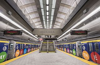
The 86th Street station is a station on the first phase of the Second Avenue Line of the New York City Subway. Located at the intersection of Second Avenue and 86th Street, in the Yorkville section of the Upper East Side in Manhattan, it opened on January 1, 2017. The station is served by the Q train at all times, limited southbound rush hour N trains, and one northbound A.M. rush hour R train. There are two tracks and an island platform.

<span class="mw-page-title-main">M86 (New York City bus)</span> Bus route in Manhattan, New York

The 86th Street Crosstown Line is a bus line in Manhattan, New York City, running mostly along 86th Street on the Upper West and Upper East Sides of Manhattan. Originally a streetcar line, it now comprises the M86 Select Bus Service bus line.

<span class="mw-page-title-main">225 East 86th Street</span> Residential building in Manhattan, New York

225 East 86th Street is a luxury condominium on 86th Street between Second Avenue and Third Avenue in the Yorkville neighborhood of the Upper East Side of Manhattan, New York City. It is a 15-story building that was built in 1981 and converted to a condo in 1986. The building was described in great detail and was quoted as being "Post-Baroque fun with windows" in the AIA Guide to New York City. The building is formally known as The Buckingham East.

References

  1. 1 2 "NYC Planning | Community Profiles". communityprofiles.planning.nyc.gov. New York City Department of City Planning. Retrieved March 18, 2019.
  2. "Yorkville neighborhood in New York" . Retrieved August 13, 2018.[ permanent dead link ]
  3. Demographics by Neighborhood Tabulation Area (NTA), New York City Department for the Aging, November 2020. Accessed April 9, 2024.
  4. Hughes, C. J. (June 1, 2008). "Living in Yorkville: Where Change Is Underfoot, and Overhead". The New York Times . Retrieved July 12, 2013.
  5. LLC, Historic Map Works. "Map - Page 1, Atlas: The Seat of Action Between the British and American Forces.... Long Island, Historical Map". www.historicmapworks.com.
  6. McCullough, David (2006), 1776, New York: Simon and Schuster Paperback, ISBN   0-7432-2672-0
  7. "Search results - NYPL Digital Collections". digitalcollections.nypl.org.
  8. "Happy Birthday to the New York & Harlem Railroad – 180 years!". I Ride The Harlem Line. April 25, 2011.
  9. "Sheet 14: [Bounded by E. Ninety Second Street, Avenue A, E. Nintieth Street, Avenue B, E. Seventy Second Street, Avenue A, [E. Fifty Ninth Street] and 5th Avenue.]". NYPL Digital Collections.
  10. Croton-On-Hudson Historical Society (2001). Images of America Series. Arcadia Publishing. pp. 41, 128. ISBN   0738505439.
  11. 1 2 3 "Yorkville Bank: Early History and Development of Yorkville" (PDF). Landmarks Preservation Commission. Archived from the original (PDF) on November 3, 2012. Retrieved 2013-01-12.
  12. 1 2 3 Jackson, Kenneth T., ed. (2010). The Encyclopedia of New York City (2nd ed.). New Haven: Yale University Press. ISBN   978-0-300-11465-2., p. 1428
  13. 1 2 "Yorkville vs. Park Slope: See how these New York City neighborhoods stack up". NY Daily News. December 12, 2013. Retrieved February 27, 2015.
  14. Gerald Handel (2000). Making a Life in Yorkville: Experience and Meaning in the Life-Course Narrative of an Urban Working-Class Man. Contributions in Sociology Series, 130. ABC-Clio; Greenwood Publishing Group. pp. 1, 149. ISBN   0313313075.
  15. King, Gilbert. "A Spectacle of Horror – The Burning of the General Slocum; The deadliest disaster in New York before 9/11 killed many women and children and ultimately erased a German community from the map of Manhattan.", Smithsonian magazine , February 21, 2012. Accessed May 18, 2016. "The men of Little Germany were suddenly without families. Funerals were held for more than a week, and the desolate schoolyards of Kleindeutschland were painful reminders of their loss. Many widowers and broken families moved uptown to Yorkville to be closer to the scene of the disaster, establishing a new Germantown on Manhattan’s Upper East Side."
  16. Collins, Glenn (June 8, 2004). "A 100-Year-Old Horror, Through 9/11 Eyes; In the Sinking of the Slocum, a Template For the Arc of a City's Grief and Recovery". The New York Times . Retrieved November 20, 2007. The disaster helped accelerate the flight of Germans from the Lower East Side to Yorkville and other neighborhoods, although there were other motivations as well. 'The very dense old housing on the Lower East Side was no longer attractive to upwardly mobile Germans,' said Dr. John Logan, director of the Center for Social and Demographic Analysis at the State University of New York at Albany.
  17. Strausbaugh, John (September 14, 2007). "Paths of Resistance in the East Village". The New York Times . Retrieved December 29, 2007. On June 15, 1904, about 1,200 people from St. Mark's Evangelical Lutheran Church (323 Sixth Street, between First and Second Avenues, the site of the Community Synagogue since 1940) died when the steamship the General Slocum, taking them on a day trip up the East River, burned. It was the deadliest disaster in the city before Sept. 11, 2001. It traumatized the community and hastened residents' flight to uptown areas like Yorkville.
  18. 1 2 Noble, Barbara Presley (July 23, 1989). "If You're Thinking of Living In: Yorkville". The New York Times . Retrieved July 31, 2010.
  19. David W. Dunlap (April 19, 2008). "In the Heart of Yorkville, Life Has Changed for German Catholics". The New York Times . Archived from the original on November 2, 2015. Retrieved January 12, 2013.
  20. "The History of Yorkville" by Kathryn A. Jolowicz
  21. "A Guide To The NYC St. Patrick's Day Parade", CBS New York, March 15, 2013
  22. 1 2 3 "Letters; Yorkville Recalled". The New York Times . July 3, 1983. Retrieved July 31, 2010.
  23. Gray, Christopher. "Streetscapes/Sutton Place, Sutton Place South and One Sutton Place North; A Prestigious Enclave With a Name in Question", The New York Times , September 21, 2003. Accessed December 27, 2007.
  24. Pollak, Michael. "F. Y. I.", The New York Times , August 7, 2005. Accessed October 16, 2007. "In 1928, Sutton Place from 59th to 60th Street, and Avenue A north of 60th, were renamed York Avenue in honor of Sgt. Alvin C. York (1887–1964), a World War I hero from Tennessee and a recipient of the Medal of Honor."
  25. During his attack on October 8, 1918, York captured four German officers and 128 men and several guns. "Medal of Honor Recipients – World War I". United States Army Center of Military History.
  26. German American Bund, Federal Bureau of Investigation. Accessed April 9, 2024.
  27. German American Bund, United States Holocaust Memorial Museum. Accessed April 9, 2024.
  28. American Nazism and Madison Square Garden, The National WWII Museum, April 14, 2021. Accessed April 9, 2024.
  29. "Little Hungary", Forgotten New York
  30. Table PL-P5 NTA: Total Population and Persons Per Acre – New York City Neighborhood Tabulation Areas*, 2010, Population Division – New York City Department of City Planning, February 2012. Accessed May 18, 2016.
  31. Table PL-P3A NTA: Total Population by Mutually Exclusive Race and Hispanic Origin – New York City Neighborhood Tabulation Areas*, 2010, Population Division – New York City Department of City Planning, March 29, 2011. Accessed May 18, 2016.
  32. "Race / Ethnic Change by Neighborhood" (Excel file). Center for Urban Research, The Graduate Center, CUNY. May 23, 2011. Retrieved March 21, 2020.
  33. "Yorkville neighborhood in New York, New York (NY)". city-data.com. Retrieved January 12, 2013.
  34. "NYPD – 19th Precinct". www.nyc.gov. New York City Police Department . Retrieved October 3, 2016.
  35. "Upper East Side, Central Park – DNAinfo.com Crime and Safety Report". www.dnainfo.com. Archived from the original on April 15, 2017. Retrieved October 6, 2016.
  36. "19th Precinct CompStat Report" (PDF). www.nyc.gov. New York City Police Department . Retrieved March 14, 2020.
  37. "FDNY Firehouse Listing – Location of Firehouses and companies". NYC Open Data; Socrata . New York City Fire Department. September 10, 2018. Retrieved March 14, 2019.
  38. "Engine Company 44". FDNYtrucks.com. Retrieved March 14, 2019.
  39. "Engine Company 22/Ladder Company 13/Battalion 10". FDNYtrucks.com. Retrieved March 14, 2019.
  40. "Upper East Side, New York City-Manhattan, New York Zip Code Boundary Map (NY)". United States Zip Code Boundary Map (USA). Retrieved March 24, 2019.
  41. "Location Details: Cherokee". USPS.com. Retrieved March 7, 2019.
  42. "Location Details: Gracie". USPS.com. Retrieved March 7, 2019.
  43. "Location Details: Yorkville". USPS.com. Retrieved March 7, 2019.
  44. "Administrative Offices." City University of New York. Retrieved on May 4, 2010.
  45. History of The Upper East Side and Yorkville, visitmanhattanapartments.com
  46. "About the Yorkville Library". The New York Public Library. May 10, 1907. Retrieved March 23, 2019.
  47. "About the Webster Library". The New York Public Library. May 10, 1907. Retrieved March 23, 2019.
  48. 1 2 "Subway Map" (PDF). Metropolitan Transportation Authority. September 2021. Retrieved September 17, 2021.
  49. "Road Map of Manhattan, New York". aaccessmaps.com. Archived from the original on January 19, 2013. Retrieved January 12, 2013.
  50. "Manhattan Bus Map" (PDF). Metropolitan Transportation Authority. July 2019. Retrieved December 1, 2020.
  51. Hughes, C.J. "Yorkville Bets on the Second Avenue Subway", The New York Times , April 8, 2016. Accessed May 18, 2016. "But the new subway stations at East 72nd, East 86th and East 96th Streets, and the expanded one at East 63rd, seem to be having an equalizing effect on prices in what used to be more of a cotton socks district."
  52. DNAinfoNewYork. "Proposed Routes for NYC's Expanded Ferry Service". Scribd. Retrieved September 22, 2016.
  53. Creag, Katherine (August 15, 2018). "New Yorkers Have a New, $2.75 Way to Get Around NYC". NBC New York. Retrieved August 29, 2018.
  54. Rivoli, Dan (August 15, 2018). "Setting sail from Soundview in new NYC ferry". nydailynews.com. Retrieved August 29, 2018.
  55. "History of the Manhattan Chamber of Commerce". October 20, 2009. Archived from the original on November 13, 2010. Retrieved October 20, 2009.
  56. Marjorie Pearson and Elizabeth Spencer-Ralph (October 1978). "National Register of Historic Places Registration: Municipal Asphalt Plant". New York State Office of Parks, Recreation and Historic Preservation. Archived from the original on October 19, 2012. Retrieved March 25, 2011.See also: "Accompanying two photos". Archived from the original on April 2, 2015.
  57. Allon, Janet (March 2, 1997). "Asphalt Green Gym Is Nearly All Roof, and It's Leaky". The New York Times .
  58. NYC East 91st Waste Facility Archived April 18, 2012, at the Wayback Machine
  59. "After deliberation, de Blasio supports the Upper East Side waste facility again". Capital New York. May 31, 2013. Retrieved February 27, 2015.
  60. "Opponents to File Lawsuit in Fight Against E 91st Street Trash Facility". DNA Info. July 25, 2012. Archived from the original on March 12, 2015. Retrieved February 27, 2015.
  61. McCart, Melissa (January 8, 2024). "The Papaya King Comeback Is Over Before it Started". Eater NY. Retrieved January 20, 2024.
  62. "Ruppert Yorkville Towers". Ruppert Yorkville Towers. Retrieved April 22, 2020.
  63. Lubasch, Arnold H. (February 26, 1961). "Cousy Is Considering Retirement". The New York Times . p. S7. Retrieved July 31, 2010.
  64. Dubner, Stephen J. (November 29, 1993). ""My Art Belongs to Daddy"". New York Magazine . New York: New York Media, LLC. Retrieved January 16, 2024.
  65. Sullivan, Eric (March 27, 2023). ""Kieran Culkin Bares (a Lot of) His Soul"". Esquire . Archived from the original on January 16, 2024. Retrieved January 16, 2024.
  66. Gendron, Nico (July 27, 2017). "The Many Lives of Julia Fox", Office Magazine. Archived from the original on January 28, 2021. Accessed February 29, 2024. "Fox didn’t always like to be photographed. She was raised in Yorkville in the 90’s, a neighborhood on the Upper East Side that has since been gentrified."
  67. "Plaque for Gehrig's Birthplace". The Miami News . Associated Press. August 22, 1953. Retrieved November 14, 2014.
  68. Rowley, Hazel (2011). Franklin and Eleanor: An Extraordinary Marriage. Melbourne University Publishing. p. 212. ISBN   9780522851793 . Retrieved November 7, 2018.
  69. Kahn, David. Hitler's Spies: German Military Intelligence in World War II, p. 327. Da Capo Press, 2000. ISBN   9780306809491. Accessed May 20, 2016. "He was Ignatz T. Griebl, a bespectacled physician who was one of the most notorious womanizers in, and a leader of, Manhattan's German colony of Yorkville."
  70. "Longtime Fashion Designer Norma Kamali Infuses Her Work With Accessibility, Empowerment" Archived December 26, 2013, at the Wayback Machine by Budd Mishkin, One On 1, April 30, 2012
  71. Bierut, Michael. "Helmut Krone, Period.", Design Observer, August 23, 2006. Accessed May 20, 2016. "Challis's book is filled with this kind of detail. Born in 1925 to immigrant parents in Yorkville, Manhattan's German enclave, he attended the High School for Industrial Art, where he hoped to become a product designer."
  72. "Bert Lahr", Turner Classic Movies
  73. "Comedy Wizard Dies at 72", St. Petersburg Times , December 5, 1967. Accessed May 20, 2016. "Born Bert Lahrheim to an immigrant German family in New York's Yorkville section, Lahr dropped out of school at 15 and joined a child vaudeville troupe."
  74. Malcolm, Janet (2023). Still Pictures: On Photography and Memory (1st ed.). New York: Farrar, Straus and Giroux. pp. 9–42. ISBN   978-0374605131.
  75. Strausbaugh, John (December 14, 2007). "In the Mansion Land of the 'Fifth Avenoodles'". The New York Times . Retrieved January 30, 2008.
  76. Marx, Harpo (1962). Harpo Speaks!. Limelight Editions. ISBN   0-87910-036-2.
  77. Whitman, Alden. "Henry Miller, 88, Dies in California; A Credo of Hedonism Henry Miller, the Writer, Is Dead at 88 Travel Book Praised Some Tender Moments Books Outraged Many 'Just a Brooklyn Boy' Lamentations for Culture 'I Just Start Something'", The New York Times , June 9, 1980. Accessed May 20, 2016. "Henry Valentine Miller was born in the Yorkville section of Manhattan on Dec. 26, 1891, the son of a German-American tailor."
  78. "John P. Morrissey, Legislator, Dies; Yorkville Democrat Served in Assembly and Senate", The New York Times , October 31, 1966. Accessed May 20, 2016. "Mr. Morrisey, an engineer, had been a Democratic district leader in Yorkville 35 years and had represented the area in the Assembly."
  79. Lee, Jennifer 8. (January 30, 2008). "Where Obama Lived in 1980s New York". The New York Times . Retrieved January 30, 2008.{{cite news}}: CS1 maint: numeric names: authors list (link)
  80. John Freeman Gill (November 16, 2012). "More Small Dogs and Big Home Prices". The New York Times. Archived from the original on January 26, 2013. Retrieved January 12, 2013.
  81. Georgette Seabrook Powell, The HistoryMakers, November 8, 2006. Accessed May 20, 2016. "Art therapist, non-profit chief executive, and painter Georgette Ernestine Seabrooke Powell was born on August 2, 1916 in Charleston, South Carolina to Anna and George Seabrooke. Powell grew up in the Yorkville neighborhood of New York City."
  82. Adams, Frank S. "SENATOR ROBERT F. WAGNER and the Rise of American Liberalism. By J. Joseph Huthmacher. 362 pages. Atheneum. $10.", End Papers, The New York Times , December 20, 1968. Accessed May 20, 2016. "How Bob Wagner, who came here as a boy of 9 from his native Germany and grew up in Yorkville, where his father was a janitor, became one of the key members of the New Deal and helped shape the basic labor-industrial relationships that still exist today is told in great detail in this sound but not very lively book by a Rutgers history professor."
  83. Puzo, Mario (2006). The Godfather's Revenge. Penguin. p. 94. ISBN   9780399153846 . Retrieved October 20, 2009.