
Orogeny is a mountain-building process that takes place at a convergent plate margin when plate motion compresses the margin. An orogenic belt or orogen develops as the compressed plate crumples and is uplifted to form one or more mountain ranges. This involves a series of geological processes collectively called orogenesis. These include both structural deformation of existing continental crust and the creation of new continental crust through volcanism. Magma rising in the orogen carries less dense material upwards while leaving more dense material behind, resulting in compositional differentiation of Earth's lithosphere. A synorogenic process or event is one that occurs during an orogeny.

A thrust fault is a break in the Earth's crust, across which older rocks are pushed above younger rocks.

The Alps form part of a Cenozoic orogenic belt of mountain chains, called the Alpide belt, that stretches through southern Europe and Asia from the Atlantic all the way to the Himalayas. This belt of mountain chains was formed during the Alpine orogeny. A gap in these mountain chains in central Europe separates the Alps from the Carpathians to the east. Orogeny took place continuously and tectonic subsidence has produced the gaps in between.
Obduction is a geological process whereby denser oceanic crust is scraped off a descending ocean plate at a convergent plate boundary and thrust on top of an adjacent plate. When oceanic and continental plates converge, normally the denser oceanic crust sinks under the continental crust in the process of subduction. Obduction, which is less common, normally occurs in plate collisions at orogenic belts or back-arc basins.

The geology of the Appalachians dates back more than 1.2 billion years to the Mesoproterozoic era when two continental cratons collided to form the supercontinent Rodinia, 500 million years prior to the development of the range during the formation of Pangea. The rocks exposed in today's Appalachian Mountains reveal elongate belts of folded and thrust faulted marine sedimentary rocks, volcanic rocks, and slivers of ancient ocean floor—strong evidences that these rocks were deformed during plate collision. The birth of the Appalachian ranges marks the first of several mountain building plate collisions that culminated in the construction of Pangea with the Appalachians and neighboring Anti-Atlas mountains near the center. These mountain ranges likely once reached elevations similar to those of the Alps and the Rocky Mountains before they were eroded.

Tectonics are the processes that result in the structure and properties of the Earth's crust and its evolution through time.

In geology, a nappe or thrust sheet is a large sheetlike body of rock that has been moved more than 2 km (1.2 mi) or 5 km (3.1 mi) above a thrust fault from its original position. Nappes form in compressional tectonic settings like continental collision zones or on the overriding plate in active subduction zones. Nappes form when a mass of rock is forced over another rock mass, typically on a low angle fault plane. The resulting structure may include large-scale recumbent folds, shearing along the fault plane, imbricate thrust stacks, fensters and klippes.
The Lewis Overthrust is a geologic thrust fault structure of the Rocky Mountains found within the bordering national parks of Glacier in Montana, United States and Waterton Lakes in Alberta, Canada. The structure was created due to the collision of tectonic plates about 59-75 million years ago that drove a several mile thick wedge of Precambrian rock 50 mi (80 km) eastwards, causing it to overlie softer Cretaceous age rock that is 1300 to 1400 million years younger.

Décollement is a gliding plane between two rock masses, also known as a basal detachment fault. Décollements are a deformational structure, resulting in independent styles of deformation in the rocks above and below the fault. They are associated with both compressional settings and extensional settings.
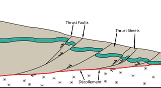
Thrust tectonics or contractional tectonics is concerned with the structures formed by, and the tectonic processes associated with, the shortening and thickening of the crust or lithosphere. It is one of the three main types of tectonic regime, the others being extensional tectonics and strike-slip tectonics. These match the three types of plate boundary, convergent (thrust), divergent (extensional) and transform (strike-slip). There are two main types of thrust tectonics, thin-skinned and thick-skinned, depending on whether or not basement rocks are involved in the deformation. The principle geological environments where thrust tectonics is observed are zones of continental collision, restraining bends on strike-slip faults and as part of detached fault systems on some passive margins.

An accretionary wedge or accretionary prism forms from sediments accreted onto the non-subducting tectonic plate at a convergent plate boundary. Most of the material in the accretionary wedge consists of marine sediments scraped off from the downgoing slab of oceanic crust, but in some cases the wedge includes the erosional products of volcanic island arcs formed on the overriding plate.
This is a list of articles related to plate tectonics and tectonic plates.

Thin-skinned deformation is a style of deformation in plate tectonics at a convergent boundary which occurs with shallow thrust faults that only involves cover rocks, and not deeper basement rocks.

The Pyrenees are a 430-kilometre-long, roughly east–west striking, intracontinental mountain chain that divide France, Spain, and Andorra. The belt has an extended, polycyclic geological evolution dating back to the Precambrian. The chain's present configuration is due to the collision between the microcontinent Iberia and the southwestern promontory of the European Plate. The two continents were approaching each other since the onset of the Upper Cretaceous (Albian/Cenomanian) about 100 million years ago and were consequently colliding during the Paleogene (Eocene/Oligocene) 55 to 25 million years ago. After its uplift, the chain experienced intense erosion and isostatic readjustments. A cross-section through the chain shows an asymmetric flower-like structure with steeper dips on the French side. The Pyrenees are not solely the result of compressional forces, but also show an important sinistral shearing.
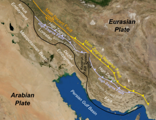
The Zagros fold and thrust belt is an approximately 1,800-kilometre (1,100 mi) long zone of deformed crustal rocks, formed in the foreland of the collision between the Arabian Plate and the Eurasian Plate. It is host to one of the world's largest petroleum provinces, containing about 49% of the established hydrocarbon reserves in fold and thrust belts (FTBs) and about 7% of all reserves globally.
Tectonic subsidence is the sinking of the Earth's crust on a large scale, relative to crustal-scale features or the geoid. The movement of crustal plates and accommodation spaces produced by faulting brought about subsidence on a large scale in a variety of environments, including passive margins, aulacogens, fore-arc basins, foreland basins, intercontinental basins and pull-apart basins. Three mechanisms are common in the tectonic environments in which subsidence occurs: extension, cooling and loading.
Thick-skinned deformation is a geological term which refers to crustal shortening that involves basement rocks and deep-seated faults as opposed to only the upper units of cover rocks above the basement which is known as thin-skinned deformation. While thin-skinned deformation is common in many different localities, thick-skinned deformation requires much more strain to occur and is a rarer type of deformation.
The Hormuz Formation, Hormuz Series, Hormuz Evaporites or Hormuz Group is a sequence of evaporites that were deposited during the Ediacaran to Early Cambrian, a period previously referred to as the Infra-Cambrian. Most exposures of this sequence are in the form of emergent salt diapirs within anticlines of the Zagros fold and thrust belt. As a result of their involvement in post-depositional salt tectonics, the internal stratigraphy of the sequence is relatively poorly understood. They are the lateral equivalent of the evaporite-bearing Ara Group in the South Oman Basin.
The geology of Sicily records the collision of the Eurasian and the African plates during westward-dipping subduction of the African slab since late Oligocene. Major tectonic units are the Hyblean foreland, the Gela foredeep, the Apenninic-Maghrebian orogen, and the Calabrian Arc. The orogen represents a fold-thrust belt that folds Mesozoic carbonates, while a major volcanic unit is found in an eastern portion of the island. The collision of Africa and Eurasia is a retreating subduction system, such that the descending Africa is falling away from Eurasia, and Eurasia extends and fills the space as the African plate falls into the mantle, resulting in volcanic activity in Sicily and the formation of Tyrrhenian slab to the north.
The geology of Iraq includes thick sequences of marine and continental sedimentary rocks over poorly understood basement rock, at the junction of the Arabian Plate, the Anatolian Plate, and the Iranian Plate.
