Back-arc basin

Last updated
Cross-section through the shallow part of a subduction zone showing the relative positions of an active magmatic arc and back-arc basin, such as the southern part of the Izu-Bonin-Mariana Arc. Volcanic Arc System SVG en.svg
Cross-section through the shallow part of a subduction zone showing the relative positions of an active magmatic arc and back-arc basin, such as the southern part of the Izu–Bonin–Mariana Arc.

A back-arc basin is a type of geologic basin, found at some convergent plate boundaries. Presently all back-arc basins are submarine features associated with island arcs and subduction zones, with many found in the western Pacific Ocean. Most of them result from tensional forces, caused by a process known as oceanic trench rollback, where a subduction zone moves towards the subducting plate. [1] Back-arc basins were initially an unexpected phenomenon in plate tectonics, as convergent boundaries were expected to universally be zones of compression. However, in 1970, Dan Karig published a model of back-arc basins consistent with plate tectonics. [2]

Contents

Cross-section sketch showing the development of a back-arc basin by rifting the arc longitudinally. The rift matures to the point of seafloor spreading, allowing a new magmatic arc to form on the trenchward side of the basin (to the right in this image) and stranding a remnant arc on the far side of the basin (to the left in this image). BAB formation.jpg
Cross-section sketch showing the development of a back-arc basin by rifting the arc longitudinally. The rift matures to the point of seafloor spreading, allowing a new magmatic arc to form on the trenchward side of the basin (to the right in this image) and stranding a remnant arc on the far side of the basin (to the left in this image).

Structural characteristics

Back-arc basins are typically very long and relatively narrow, often thousands of kilometers long while only being a few hundred kilometers wide at most. For back-arc extension to form, a subduction zone is required, but not all subduction zones have a back-arc extension feature. [3] Back-arc basins are found in areas where the subducting plate of oceanic crust is very old. [3] The restricted width of back-arc basins is due to magmatic activity being reliant on water and induced mantle convection, limiting their formation to along subduction zones. [3] Spreading rates vary from only a few centimeters per year (as in the Mariana Trough), to 15 cm/year in the Lau Basin. [4] Spreading ridges within the basins erupt basalts that are similar to those erupted from the mid-ocean ridges; the main difference being back-arc basin basalts are often very rich in magmatic water (typically 1–1.5 weight % H2O), whereas mid-ocean ridge basalt magmas are very dry (typically <0.3 weight % H2O). The high water contents of back-arc basin basalt magmas is derived from water carried down the subduction zone and released into the overlying mantle wedge. [1] Additional sources of water could be the eclogitization of amphiboles and micas in the subducting slab. Similar to mid-ocean ridges, back-arc basins have hydrothermal vents and associated chemosynthetic communities.

Seafloor spreading

Evidence of seafloor spreading has been seen in cores of the basin floor. The thickness of sediment that collected in the basin decreased toward the center of the basin, indicating a younger surface. The idea that thickness and age of sediment on the sea floor is related to the age of the oceanic crust was proposed by Harry Hess. [5] Magnetic anomalies of the crust that had formed in back-arc basins deviated in form from the crust formed at mid-ocean ridges. [2] In many areas the anomalies do not appear parallel, as well as the profiles of the magnetic anomalies in the basin lacking symmetry or a central anomaly as a traditional ocean basin does, indicating asymmetric seafloor spreading. [2]

This has prompted some to characterize the spreading in back-arc basins to be more diffused and less uniform than at mid-ocean ridges. [6] The idea that back-arc basin spreading is inherently different from mid-ocean ridge spreading is controversial and has been debated through the years. [6] Another argument put forward is that the process of seafloor spreading is the same in both cases, but the movement of seafloor spreading centers in the basin causes the asymmetry in the magnetic anomalies. [6] This process can be seen in the Lau back-arc basin. [6] Though the magnetic anomalies are more complex to decipher, the rocks sampled from back-arc basin spreading centers do not differ very much from those at mid-ocean ridges. [7] In contrast, the volcanic rocks of the nearby island arc differ significantly from those in the basin. [7]

The islands of Japan were separated from mainland Asia by back-arc spreading. Japan separation.png
The islands of Japan were separated from mainland Asia by back-arc spreading.

Back-arc basins are different from normal mid-ocean ridges because they are characterized by asymmetric seafloor spreading, but this is quite variable even within single basins. For example, in the central Mariana Trough, current spreading rates are 2–3 times greater on the western flank, [8] whereas at the southern end of the Mariana Trough the position of the spreading center adjacent to the volcanic front suggests that overall crustal accretion has been nearly entirely asymmetric there. [9] This situation is mirrored to the north where a large spreading asymmetry is also developed. [10]

Other back-arc basins such as the Lau Basin have undergone large rift jumps and propagation events (sudden changes in relative rift motion) that have transferred spreading centers from arc-distal to more arc-proximal positions. [11] Conversely, study of recent spreading rates appear to be relatively symmetric with perhaps small rift jumps. [12] The cause of asymmetric spreading in back-arc basins remains poorly understood. General ideas invoke asymmetries relative to the spreading axis in arc melt generation processes and heat flow, hydration gradients with distance from the slab, mantle wedge effects, and evolution from rifting to spreading. [13] [14] [15]

Formation and tectonics

The extension of the crust behind volcanic arcs is believed to be caused by processes in association with subduction. [1] As the subducting plate descends into the asthenosphere it sheds water, causing mantle melting, volcanism, and the formation of island arcs. Another result of this is a convection cell is formed. [1] The rising magma and heat along with the outwards tension in the crust in contact with the convection cell cause a region of melt to form, resulting in a rift. This process drives the island arc toward the subduction zone and the rest of the plate away from the subduction zone. [1] The backward motion of the subduction zone relative to the motion of the plate which is being subducted is called trench rollback (also known as hinge rollback or hinge retreat). As the subduction zone and its associated trench pull backward, the overriding plate is stretched, thinning the crust and forming a back-arc basin. In some cases, extension is triggered by the entrance of a buoyant feature in the subduction zone, which locally slows down subduction and induces the subducting plate to rotate adjacent to it. This rotation is associated with trench retreat and overriding plate extension. [9]

The age of the subducting crust needed to establish back-arc spreading has been found to be 55 million years old or older. [15] [3] This is why back-arc spreading centers appear concentrated in the western Pacific. [3] The dip angle of the subducting slab may also be significant, as is shown to be greater than 30° in areas of back-arc spreading; this is most likely because as oceanic crust gets older it becomes denser, resulting in a steeper angle of descent. [3]

The thinning of the overriding plate from back-arc rifting can lead to the formation of new oceanic crust (i.e., back-arc spreading). As the lithosphere stretches, the asthenosphere below rises to shallow depths and partially melts as a result of adiabatic decompression melting. As this melt nears the surface, spreading begins.

Sedimentation

Sedimentation is strongly asymmetric, with most of the sediment supplied from the active volcanic arc which regresses in step with the rollback of the trench. [16] From cores collected during the Deep Sea Drilling Project (DSDP) nine sediment types were found in the back-arc basins of the western Pacific. [16] Debris flows of thick to medium bedded massive conglomerates account for 1.2% of sediments collected by the DSDP. [16] The average size of the sediments in the conglomerates are pebble sized but can range from granules to cobbles. [16] Accessory materials include limestone fragments, chert, shallow water fossils and sandstone clasts. [16]

Submarine fan systems of interbedded turbidite sandstone and mudstone made up 20% of the total thickness of sediment recovered by the DSDP. [16] The fans can be divided into two sub-systems based on the differences in lithology, texture, sedimentary structures, and bedding style. [16] These systems are inner and midfan subsystem and the outer fan subsystem. [16] The inner and midfan system contains interbedded thin to medium bedded sandstones and mudstones. [16] Structures that are found in these sandstones include load clasts, micro-faults, slump folds, convolute laminations, dewatering structures, graded bedding, and gradational tops of sandstone beds. [16] Partial Bouma sequences can be found within the subsystem. [16] The outer fan subsystem generally consists of finer sediments when compared to the inner and midfan system. [16] Well sorted volcanoclastic sandstones, siltstones and mudstones are found in this system. [16] Sedimentary structures found in this system include parallel laminae, micro-cross laminae, and graded bedding. [16] Partial Bouma sequences can be identified in this subsystem. [16]

Pelagic clays containing iron-manganese micronodules, quartz, plagioclase, orthoclase, magnetite, volcanic glass, montmorillonite, illite, smectite, foraminiferal remains, diatoms, and sponge spicules made up the uppermost stratigraphic section at each site it was found. This sediment type consisted of 4.2% of the total thickness of sediment recovered by the DSDP. [16]

Biogenic pelagic silica sediments consist of radiolarian, diatomaceous, silicoflagellate oozes, and chert. [16] It makes up 4.3% of the sediment thickness recovered. [16] Biogenic pelagic carbonates is the most common sediment type recovered from the back-arc basins of the western Pacific. [16] This sediment type made up 23.8% of the total thickness of sediment recovered by the DSDP. [16] The pelagic carbonates consist of ooze, chalk, and limestone. [16] Nanofossils and foraminifera make up the majority of the sediment. [16] Resedimented carbonates made up 9.5% of the total thickness of sediment recovered by the DSDP. [16] This sediment type had the same composition as the biogenic pelagic carbonated, but it had been reworked with well-developed sedimentary structures. [16] Pyroclastics consisting of volcanic ash, tuff and a host of other constituents including nanofossils, pyrite, quartz, plant debris, and glass made up 9.5% of the sediment recovered. [16] These volcanic sediments were sourced form the regional tectonic controlled volcanism and the nearby island arc sources. [16]

The active back-arc basins of the world BAB of the World -Converted-.jpg
The active back-arc basins of the world

Locations

Active back-arc basins are found in the Marianas, Kermadec-Tonga, South Scotia, Manus, North Fiji, and Tyrrhenian Sea regions, but most are found in the western Pacific. Not all subduction zones have back-arc basins, some like the central Andes are associated with rear-arc compression.

There are a number of extinct or fossil back-arc basins, such as the Parece Vela-Shikoku Basin, Sea of Japan, and Kurile Basin. Compressional back-arc basins are found, for example, in the Pyrenees and the Swiss Alps. [17]

History of thought

With the development of plate tectonic theory, geologists thought that convergent plate margins were zones of compression, thus zones of strong extension above subduction zones (back-arc basins) were not expected. The hypothesis that some convergent plate margins were actively spreading was developed by Dan Karig in 1970, while a graduate student at the Scripps Institution of Oceanography. [2] This was the result of several marine geologic expeditions to the western Pacific.

See also

Notes

  1. 1 2 3 4 5 Forsyth, D; Uyeda, S (1975). "On the Relative Importance of the Driving Forces of Plate Motion". Geophysical Journal International. 7 (4): 163–200. Bibcode:1975GeoJ...43..163F. doi: 10.1111/j.1365-246X.1975.tb00631.x .
  2. 1 2 3 4 Karig, Daniel (1970). "Ridges and basins of the Tonga-Kermadec island arc system". Journal of Geophysical Research. 75 (2): 239–254. Bibcode:1970JGR....75..239K. doi:10.1029/JB075i002p00239.
  3. 1 2 3 4 5 6 Sdrolias, M; Muller, R.D. (2006). "Controls on back-arc basin formations". Geochemistry, Geophysics, Geosystems. 7 (4): Q04016. Bibcode:2006GGG.....7.4016S. doi: 10.1029/2005GC001090 . S2CID   129068818.
  4. Taylor, B.; Zellmer, K.; Martinez, F.; Goodliffe, A. (1996). "Sea-floor Spreading in the Lau Back-arc Basin". Earth and Planetary Science Letters. 144 (1–2): 35–40. Bibcode:1996E&PSL.144...35T. doi:10.1016/0012-821X(96)00148-3 . Retrieved 26 December 2016.
  5. Hess, Henry H (1962). "History of Ocean Basins". Petrological Studies: A Volume to Honor A .F. Buddington: 599–620.
  6. 1 2 3 4 Taylor, B; Zellmer, K; Martinez, F; Goodliffe, A (1996). "Sea-floor spreading in the Lau back-arc basin". Earth and Planetary Science Letters. 144 (1–2): 35–40. Bibcode:1996E&PSL.144...35T. doi:10.1016/0012-821x(96)00148-3.
  7. 1 2 Gill, J.B. (1976). "Composition and age of Lau Basin and Ridge volcanic rocks: Implications for evolution of an interarc basin and remnant arc". GSA Bulletin. 87 (10): 1384–1395. Bibcode:1976GSAB...87.1384G. doi:10.1130/0016-7606(1976)87<1384:CAAOLB>2.0.CO;2.
  8. Deschamps, A.; Fujiwara, T. (2003). "Asymmetric accretion along the slow-spreading Mariana Ridge". Geochem. Geophys. Geosyst. 4 (10): 8622. Bibcode:2003GGG.....4.8622D. doi:10.1029/2003GC000537.
  9. 1 2 Martinez, F.; Fryer, P.; Becker, N. (2000). "Geophysical Characteristics of the Southern Mariana Trough, 11N-13N". J. Geophys. Res. 105 (B7): 16591–16607. Bibcode:2000JGR...10516591M. doi: 10.1029/2000JB900117 .
  10. Yamazaki, T.; Seama, N.; Okino, K.; Kitada, K.; Joshima, M.; Oda, H.; Naka, J. (2003). "Spreading process of the northern Mariana Trough: Rifting-spreading transition at 22 N". Geochem. Geophys. Geosyst. 4 (9): 1075. Bibcode:2003GGG.....4....1Y. doi: 10.1029/2002GC000492 .
  11. Parson, L.M.; Pearce, J.A.; Murton, B.J.; Hodkinson, R.A.; RRS Charles Darwin Scientific Party (1990). "Role of ridge jumps and ridge propagation in the tectonic evolution of the Lau back-arc basin, southwest Pacific". Geology. 18 (5): 470–473. Bibcode:1990Geo....18..470P. doi:10.1130/0091-7613(1990)018<0470:RORJAR>2.3.CO;2.
  12. Zellmer, K.E.; Taylor, B. (2001). "A three-plate kinematic model for Lau Basin opening". Geochem. Geophys. Geosyst. 2 (5): 1020. Bibcode:2001GGG.....2.1020Z. doi:10.1029/2000GC000106. 2000GC000106.
  13. Barker, P.F.; Hill, I.A. (1980). "Asymmetric spreading in back-arc basins". Nature . 285 (5767): 652–654. Bibcode:1980Natur.285..652B. doi:10.1038/285652a0. S2CID   4233630.
  14. Martinez, F.; Fryer, P.; Baker, N.A.; Yamazaki, T. (1995). "Evolution of backarc rifting: Mariana Trough, 20-24N". J. Geophys. Res. 100 (B3): 3807–3827. Bibcode:1995JGR...100.3807M. doi:10.1029/94JB02466. Archived from the original on 2011-08-27. Retrieved 2010-05-08.
  15. 1 2 Molnar, P.; Atwater, T. (1978). "Interarc spreading and Cordilleran tectonics as alternates related to the age of subducted oceanic lithosphere". Earth Planet. Sci. Lett. 41 (3): 330–340. Bibcode:1978E&PSL..41..330M. doi:10.1016/0012-821X(78)90187-5.
  16. 1 2 3 4 5 6 7 8 9 10 11 12 13 14 15 16 17 18 19 20 21 22 23 24 25 26 Klein, G.D. (1985). "The Control of Depositional Depth, Tectonic Uplift, and Volcanism on Sedimentation Processes in the Back-Arc Basins of the Western Pacific Ocean". Journal of Geology. 93 (1): 1–25. Bibcode:1985JG.....93....1D. doi:10.1086/628916. S2CID   129527339.
  17. Munteanu, I.; et al. (2011). "Kinematics of back-arc inversion of the Western Black Sea Basin". Tectonics. 30 (5): n/a. Bibcode:2011Tecto..30.5004M. doi: 10.1029/2011tc002865 .

Related Research Articles

<span class="mw-page-title-main">Oceanic trench</span> Long and narrow depressions of the sea floor

Oceanic trenches are prominent, long, narrow topographic depressions of the ocean floor. They are typically 50 to 100 kilometers wide and 3 to 4 km below the level of the surrounding oceanic floor, but can be thousands of kilometers in length. There are about 50,000 km (31,000 mi) of oceanic trenches worldwide, mostly around the Pacific Ocean, but also in the eastern Indian Ocean and a few other locations. The greatest ocean depth measured is in the Challenger Deep of the Mariana Trench, at a depth of 10,920 m (35,830 ft) below sea level.

<span class="mw-page-title-main">Subduction</span> A geological process at convergent tectonic plate boundaries where one plate moves under the other

Subduction is a geological process in which the oceanic lithosphere and some continental lithosphere is recycled into the Earth's mantle at convergent boundaries. Where the oceanic lithosphere of a tectonic plate converges with the less dense lithosphere of a second plate, the heavier plate dives beneath the second plate and sinks into the mantle. A region where this process occurs is known as a subduction zone, and its surface expression is known as an arc-trench complex. The process of subduction has created most of the Earth's continental crust. Rates of subduction are typically measured in centimeters per year, with rates of convergence as high as 11 cm/year.

Obduction is a geological process whereby denser oceanic crust is scraped off a descending ocean plate at a convergent plate boundary and thrust on top of an adjacent plate. When oceanic and continental plates converge, normally the denser oceanic crust sinks under the continental crust in the process of subduction. Obduction, which is less common, normally occurs in plate collisions at orogenic belts or back-arc basins.

<span class="mw-page-title-main">Ophiolite</span> Uplifted and exposed oceanic crust

An ophiolite is a section of Earth's oceanic crust and the underlying upper mantle that has been uplifted and exposed, and often emplaced onto continental crustal rocks.

<span class="mw-page-title-main">Convergent boundary</span> Region of active deformation between colliding tectonic plates

A convergent boundary is an area on Earth where two or more lithospheric plates collide. One plate eventually slides beneath the other, a process known as subduction. The subduction zone can be defined by a plane where many earthquakes occur, called the Wadati–Benioff zone. These collisions happen on scales of millions to tens of millions of years and can lead to volcanism, earthquakes, orogenesis, destruction of lithosphere, and deformation. Convergent boundaries occur between oceanic-oceanic lithosphere, oceanic-continental lithosphere, and continental-continental lithosphere. The geologic features related to convergent boundaries vary depending on crust types.

<span class="mw-page-title-main">Tonga Trench</span> Deepest oceanic trench in the southwestern Pacific Ocean

The Tonga Trench is an oceanic trench located in the southwestern Pacific Ocean. It is the deepest trench in the Southern hemisphere and the second deepest on Earth after the Mariana Trench. The fastest plate-tectonic velocity on Earth is occurring at this location, as the Pacific Plate is being subducted westward in the trench.

<span class="mw-page-title-main">Island arc</span> Arc-shaped archipelago formed by intense seismic activity of long chains of active volcanoes

Island arcs are long chains of active volcanoes with intense seismic activity found along convergent tectonic plate boundaries. Most island arcs originate on oceanic crust and have resulted from the descent of the lithosphere into the mantle along the subduction zone. They are the principal way by which continental growth is achieved.

The Tonga Plate is a small southwest Pacific tectonic plate or microplate. It is centered at approximately 19° S. latitude and 173° E. longitude. The plate is an elongated plate oriented NNE - SSW and is a northward continuation of the Kermadec linear zone north of New Zealand. The plate is bounded on the east and north by the Pacific Plate, on the northwest by the Niuafo’ou Microplate, on the west and south by the Indo-Australian Plate. The Tonga plate is subducting the Pacific plate along the Tonga Trench. This subduction turns into a transform fault boundary north of Tonga. An active rift or spreading center separates the Tonga Plate from the Australian Plate and the Niuafo’ou microplate to the west. The Tonga Plate is seismically very active and is rotating clockwise.

<span class="mw-page-title-main">Izu–Bonin–Mariana Arc</span> Convergent boundary in Micronesia

The Izu–Bonin–Mariana (IBM) arc system is a tectonic plate convergent boundary in Micronesia. The IBM arc system extends over 2800 km south from Tokyo, Japan, to beyond Guam, and includes the Izu Islands, the Bonin Islands, and the Mariana Islands; much more of the IBM arc system is submerged below sealevel. The IBM arc system lies along the eastern margin of the Philippine Sea Plate in the Western Pacific Ocean. It is the site of the deepest gash in Earth's solid surface, the Challenger Deep in the Mariana Trench.

<span class="mw-page-title-main">Mariana Trough</span>

The Mariana Trough is an active back-arc basin in the western Pacific Ocean. It is an integral part of the Izu–Bonin–Mariana Arc system.

<span class="mw-page-title-main">Kermadec-Tonga subduction zone</span> Convergent plate boundary that stretches from the North Island of New Zealand northward

The Kermadec-Tonga subduction zone is a convergent plate boundary that stretches from the North Island of New Zealand northward. The formation of the Kermadec and Tonga Plates started about 4–5 million years ago. Today, the eastern boundary of the Tonga Plate is one of the fastest subduction zones, with a rate up to 24 cm/yr. The trench formed between the Kermadec-Tonga and Pacific Plates is also home to the second deepest trench in the world, at about 10,800 m, as well as the longest chain of submerged volcanoes.

<span class="mw-page-title-main">Caroline Plate</span> Minor oceanic tectonic plate north of New Guinea

The Caroline Plate is a minor tectonic plate that straddles the Equator in the eastern hemisphere located north of New Guinea. It forms a subduction zone along the border with the Bird's Head Plate and other minor plates of the New Guinea region to the south. A transform boundary forms the northern border with the Pacific Plate. Along the border with the Philippine Sea Plate is a convergent boundary that transitions into a rift.

<span class="mw-page-title-main">Mariana Plate</span> Small tectonic plate west of the Mariana Trench

The Mariana Plate is a micro tectonic plate located west of the Mariana Trench which forms the basement of the Mariana Islands which form part of the Izu–Bonin–Mariana Arc. It is separated from the Philippine Sea Plate to the west by a divergent boundary with numerous transform fault offsets. The boundary between the Mariana and the Pacific Plate to the east is a subduction zone with the Pacific Plate subducting beneath the Mariana. This eastern subduction is divided into the Mariana Trench, which forms the southeastern boundary, and the Izu–Ogasawara Trench the northeastern boundary. The subduction plate motion is responsible for the shape of the Mariana plate and back arc.

<span class="mw-page-title-main">Lau Basin</span> Oceanic basin in the South Pacific Ocean between Fiji and Tonga

The Lau Basin is a back-arc basin at the Australian-Pacific plate boundary. It is formed by the Pacific plate subducting under the Australian plate. The Tonga-Kermadec Ridge, a frontal arc, and the Lau-Colville Ridge, a remnant arc, sit to the eastern and western sides of the basin, respectively. The basin has a raised transition area to the south where it joins the Havre Trough.

<span class="mw-page-title-main">Back-arc region</span>

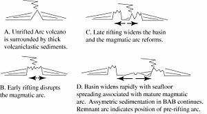
The back-arc region is the area behind a volcanic arc. In island volcanic arcs, it consists of back-arc basins of oceanic crust with abyssal depths, which may be separated by remnant arcs, similar to island arcs. In continental arcs, the back-arc region is part of continental platform, either dry land (subaerial) or forming shallow marine basins.

<span class="mw-page-title-main">Woodlark Basin</span> Oceanic basin located to the east of the island of New Guinea

The Woodlark Basin is a young geologic structural basin located in the southwestern Pacific Ocean, found to the southeast of the island country of Papua New Guinea. The basin is an extensional basin that is actively spreading and has a seafloor spreading center. This basin formed between the Indo-Australian Plate and the Solomon microplate. The Woodlark Basin has an interesting and complex geologic history dating back twenty million years to the initial opening of the basin but most of the spreading has happened in the last 3.6 million years.

The Sumatra Trench is a part of the Sunda Trench or Java Trench. The Sunda subduction zone is located in the east part of Indian Ocean, and is about 300 km (190 mi) from the southwest coast of Sumatra and Java islands. It extends over 5,000 km (3,100 mi) long, starting from Myanmar in the northwest and ending at Sumba Island in the southeast.

<span class="mw-page-title-main">Lau-Colville Ridge</span> Oceanic ridge in the south-west Pacific Ocean between Fiji and New Zealand

The Lau-Colville Ridge is an extinct oceanic ridge located on the oceanic Australian Plate in the south-west Pacific Ocean extending about 2,700 km (1,700 mi) from the south east of Fiji to the continental shelf margin of the North Island of New Zealand. It was an historic subduction boundary between the Australian Plate and the Pacific Plate and has important tectonic relationships to its east where very active spreading and subduction processes exist today. It is now the inactive part of an eastward-migrating, 100 million year old Lau-Tonga-Havre-Kermadec arc/back-arc system or complex and is important in understanding submarine arc volcanism because of these relationships. To its west is the South Fiji Basin whose northern bedrock is Oligocene in origin.

<span class="mw-page-title-main">Havre Trough</span> Oceanic rift valley in the south-west Pacific Ocean to the north of New Zealand

The Havre Trough is a currently actively rifting back-arc basin about 100 km (62 mi) to 120 km (75 mi) wide, between the Australian Plate and Kermadec microplate. The trough extends northward from New Zealand's offshore Taupō Volcanic Zone commencing at Zealandia's continental shelf margin and continuing as a tectonic feature, as the Lau Basin which currently contains active seafloor spreading centers. Its eastern margin is defined by the Kermadec Ridge created by Pacific Plate subduction under the Kermadec microplate, while the western margin is the remnant Lau-Colville Ridge.

<span class="mw-page-title-main">South Fiji Basin</span> Oceanic basin in the south-west Pacific Ocean between Fiji and New Zealand

The South Fiji Basin is a large 4 to 4.7 km deep oceanic basin in the south-west Pacific Ocean, south of Fiji. It is formed from the Australian Plate and is delimited to the north west by the New Hebrides Trench, and the Hunter Fracture Zone, to the west by the Three Kings Ridge, to the east by the Lau-Colville Ridge, and to the south by the continental shelf of Zealandia.

References