Contourite

Last updated

A contourite is a sedimentary deposit commonly formed on continental rises in lower slope settings, although it may occur anywhere that is below the storm wave base. Countourites are produced by thermohaline-induced deepwater bottom currents and may be influenced by wind or tidal forces. [1] [2] The geomorphology of contourite deposits is mainly influenced by the deepwater bottom-current velocity, sediment supply, and seafloor topography. [3]

Contents

Definition

The definition of the term contourite has varied throughout the decades. Originally, Heezen et al. (1966) [4] defined the concept, without using the actual word, as a sedimentary deposit on the continental rise derived from thermohaline-induced geostrophic bottom-currents that flow parallel to bathymetric contours. They did this to emphasise the difference between these deposits and turbidites in order to explain the ubiquitous smoothness and lack of irregularities of the continental rise in the Blake-Bahama Basin. Before this, it was thought that only turbidity flows were capable of depositing and reworking sediment at depths greater than the continental slope. [1] Hollister and Heezen (1972) [5] adopted the name contourite for these deposits and provided a list of characteristics that described their sediments. Faugères and Stow (1993) [6] note that as research on the subject developed, the term contourite was used to describe various forms of sedimentary deposits from bottom-currents, including those at much shallower depths and even in lacustrine settings. They suggested going back to the original definition of a contourite, that is, deposits at depths greater than 500 m derived from stable thermohaline-induced geostrophic bottom-currents (i.e., deepwater bottom-currents), in order to avoid using the same name when describing sedimentary deposits formed by different processes. They also suggest the umbrella term bottom-current deposit, which includes contourites and deposits generated by other bottom-currents.

Flow conditions

Bottom current flow in the Gulf of Cadiz Contourite bottom water flow IODP Gulf of Cadiz.png
Bottom current flow in the Gulf of Cadiz

Thermohaline circulation is the principal driving force of deepwater bottom currents. The term refers to the movement of water over large distances as a consequence of global oceanic density gradients. This circulation commonly travels at velocities between 2 and 20 cm/s. [4] Note that at this velocity range, considering the general shape of the Shields diagram [8] [9] still holds in these conditions, a flow will only be able to continue transporting finer sediment that is already in suspension but will not be able to erode the same-sized sediment once it is deposited. However, flow velocity may be intensified as a consequence of the Coriolis force driving currents west against continental margins or as current squeezes between two ridges. [3]

Periodically, velocities may increase dramatically or even reverse due to atmospheric storms raising the local surface eddy kinetic energy, which gets partially transmitted down to abyssal depths in episodes called benthic storms. [10] These velocities may reach magnitudes well above 40 cm/s and vary significantly depending on the specific location. At the lower continental rise, south of Halifax, Nova Scotia, [10] and at the lower slope around the Faeroe Islands [11] these velocities may reach up to 73 cm/s and 75 cm/s, respectively. Bottom-current flow velocities have been measured as high as 300 cm/s in the Strait of Gibraltar. [12] [13] These benthic storms occur only 5 to 10 times per year and usually last between 3 and 5 days, [1] but that is enough to heavily erode benthic sediment and keep the finer grains in suspension even after flow velocities return to normal and the bedload has been deposited. [3] [10] During benthic storms, the eroded sediment may be transported over thousands of kilometres and deposited rather quickly (i.e., ~1.5 cm/month) once the storm wanes. However, the net sedimentation rate over thousands of years may be much smaller (i.e. ~5.5 cm/year) due to the intense periods of erosion during benthic storms. [6]

Sediment supply

Bedform phase diagram for contourites (Stow et al. 2009) Contourite bedform diagram Stow2009.png
Bedform phase diagram for contourites (Stow et al. 2009)

Erosion of the seafloor contributes to the growth of a deepwater nepheloid layer. This layer plays a key role in supplying the sediment for the deposition of contourites under appropriate flow conditions. [3]

Terrigenous sediment supply to the deepwater bottom currents and to the nepheloid layer primarily depends on climate and tectonics in the continental environment. [3] The rate of tectonic uplift is directly related to the amount of sediment available, and variations in sea level will determine the ease with which this sediment is transported basinward. The sediment will most likely reach deepwater in the form of turbidity flows, which travel across bathymetric contours, only to be “blown” parallel to these contours as the finer sediments cross a deepwater bottom-current. [1] Other sources of terrigenous sediment may include airborne and seaborne volcanoclastic debris. [3]

Biogenic deposition from suspension may also supply sediment to these deepwater bottom currents. The deposition of this material has strong implications for the biology, chemistry, and flow, conditions at the time. It must occur in areas of high biogenic productivity, during periods of relatively quiet flow and, if calcareous, must also occur at depths above the carbonate compensation depth. [3] [6] There is also a contribution to the concentration of suspended sediment from the burrowing activity of benthic organisms. [6]

Geomorphology

The accumulation and geomorphology of contourite deposits are mainly influenced by three factors: the intensity of deepwater bottom currents, seafloor topography, and sediment supply. [3] There are five main types of contourite accumulations: giant elongate drifts, contourite sheets, channel-related drifts, confined drifts, and modified drift-turbidite systems. [3] [15]

Giant elongated drifts

Sparker seismic line showing elongate drifts in the Gulf of Cadiz Contourite sparker seismic elongate drift.png
Sparker seismic line showing elongate drifts in the Gulf of Cadiz

Giant elongate drifts form very large mounded elongated geometries parallel to the deepwater bottom-current flow. They are characterised by a near-complete lack of parallel bedding. Mounded drifts are often bounded on one or both sides by non-depositional or erosional channels, sometimes known as moats. [2] These drifts can be “tens to hundreds of kilometres long, tens of kilometres wide, and range from 0.1 to more than 1 km in relief above the surrounding seafloor”. [3] Their length-to-width ratio ranges from 2:1 to 10:1. [15] They can accumulate to thicknesses greater than 2 km and can form anywhere from the upper slope to the deepest parts of the basin, depending on the specific location of the bottom-current. [3] [15] Sedimentation rates range from 20 to 100 m/Ma. They tend to be finer-grained with a lot of mud, silt, and biogenic material. Coarse-grained contourites are very rare. [3] They may also form detached or separated versions due to seafloor topography and flow conditions. [15] Detached drifts are isolated and migrate downslope, while separated drifts are typically asymmetric in shape, tend to form at the base of a slope, and migrate up slope. [2] Large sediment waves have been observed partially covering some giant elongate drifts. [3]

Contourite sheets

Contourite sheets shown in reflection seismic data off the coast of Portugal Contourite sheets seismic gulf of cadiz.png
Contourite sheets shown in reflection seismic data off the coast of Portugal

Contourite sheets are broad, low-relief features that extend through very large areas (i.e., ~1,000,000 km2) and are seen covering the abyssal plains or even plastered against the continental margins. [3] They are characteristic of very deep water. [2] They have a relatively constant thickness of up to a few hundred metres with a slight thinning towards the continental margin. [15]

Sediment wave fields are a variety that are generally located near the rise-to-slope transition. Seismic reflection profiles show that the sediment waves tend to migrate up-slope. [16]

Channel-related drifts form when deepwater bottomcurrents are confined to a smaller cross-sectional area of flow, and therefore their velocity increases substantially. This can happen if the deepwater bottom-current is trapped within a deep channel or within a gateway that connects two basins. Due to the high velocities, it is common to see scours and erosional features, as well as different types of deposits at the floor of the channel, the flanks, and the down-current exit of the channel. [3] [15]

Flank deposits are usually patchy and small (tens of km2), can be elongate and subparallel to the flow direction, and may have a sheeted or mounded geometry. At the down-current exit of the channel, flow velocity decreases dramatically, and a cone-shaped contourite fan is formed, which is much larger than the flank deposits, measuring about 100 km in radius and about 300 m in thickness. Channel floor deposits can be patchy and contain sand, gravel, and mud clasts in the form of a channel lag. [15]

Confined drifts

Confined drifts are contourite accumulations that occur within small basins. The basins in which they form tend to be tectonically active in order to allow for the topographic confinement of the deposit. [15]

Modified drift-turbidite systems

Modified drift-turbidite systems refer to the interactions of contourite and turbidite deposits. These can be observed as modifications of one another, depending on the dominant process at the time. Examples range from asymmetric turbidite channel levees caused by strong deepwater bottom-currents, as seen in the Nova Scotian Margin, to alternations in turbidite/debrite and contourite deposits both in time and space, as seen in the Hebridean Margin. [15] The Caledonia and Judith Fancy formations in St. Croix were studied by Stanley (1993) [17] in which he found an ancient analogue of an alternating turbidite and contourite deposit and generated a stratigraphic model of a continuum from a turbidite dominant environment to a contourite dominant one.

Distinguishing turbidites, contourites, and bottom-current modified turbidite deposits is essential for reconstructing the paleoenvironment in deepwater settings. Traction structures, such as cross-stratification, indicate bottom-current reworking because it is more likely to have avalanches in clear bottom-currents than it is in sediment-saturated turbidity flows. [18] Deposition from suspension in turbidity flows does not generate a sharp upper contact as bottom-current reworked deposits show due to the highly oscillating energy conditions. Stanley (1993) [17] proposes that the transition from a turbidite to a contourite involves a continuous transition from a sandy deposit to lenticular bedding passing through wavy bedding.

Occurrence

A Global map of recent
.mw-parser-output .legend{page-break-inside:avoid;break-inside:avoid-column}.mw-parser-output .legend-color{display:inline-block;min-width:1.25em;height:1.25em;line-height:1.25;margin:1px 0;text-align:center;border:1px solid black;background-color:transparent;color:black}.mw-parser-output .legend-text{}
and fossil
contourite deposits, and larger accumulations of recent contourite deposits are summarised under contourite depositional systems
. Contourite Distribution.jpg
A Global map of recent    and fossil    contourite deposits, and larger accumulations of recent contourite deposits are summarised under contourite depositional systems   .
Map showing contourite deposition (green). (2) Too much bottom shear stress (red). (3) Too much sediment supply (brown). (4) Not enough sediment supply (light grey). (5) Not enough bottom shear stress (dark grey). source: https://onlinelibrary.wiley.com/doi/full/10.1111/bre.12788 Contourite deposition and erosion on the ocean floor.png
Map showing contourite deposition (green). (2) Too much bottom shear stress (red). (3) Too much sediment supply (brown). (4) Not enough sediment supply (light grey). (5) Not enough bottom shear stress (dark grey). source: https://onlinelibrary.wiley.com/doi/full/10.1111/bre.12788

Present day

Contourite deposition is active in many locations throughout the world, but particularly in areas affected by the thermohaline circulation.[ where? ]

Ancient examples

Identifying contourites in ancient sedimentary sequences is difficult as their distinctive morphology[ clarification needed ] becomes obscured by the effects of later bioturbation, sedimentation, erosion, and compaction. Most examples of contourites identified in the geological record come from the Cenozoic, but examples have been noted as far back as the Ediacaran. [19]

See also

Related Research Articles

<span class="mw-page-title-main">Sedimentary rock</span> Rock formed by the deposition and cementation of particles

Sedimentary rocks are types of rock that are formed by the accumulation or deposition of mineral or organic particles at Earth's surface, followed by cementation. Sedimentation is the collective name for processes that cause these particles to settle in place. The particles that form a sedimentary rock are called sediment, and may be composed of geological detritus (minerals) or biological detritus. The geological detritus originated from weathering and erosion of existing rocks, or from the solidification of molten lava blobs erupted by volcanoes. The geological detritus is transported to the place of deposition by water, wind, ice or mass movement, which are called agents of denudation. Biological detritus was formed by bodies and parts of dead aquatic organisms, as well as their fecal mass, suspended in water and slowly piling up on the floor of water bodies. Sedimentation may also occur as dissolved minerals precipitate from water solution.

<span class="mw-page-title-main">Sediment</span> Particulate solid matter that is deposited on the surface of land

Sediment is a naturally occurring material that is broken down by processes of weathering and erosion, and is subsequently transported by the action of wind, water, or ice or by the force of gravity acting on the particles. For example, sand and silt can be carried in suspension in river water and on reaching the sea bed deposited by sedimentation; if buried, they may eventually become sandstone and siltstone through lithification.

<span class="mw-page-title-main">River delta</span> Silt deposition landform at the mouth of a river

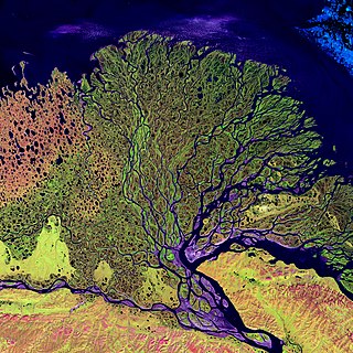
A river delta is a landform shaped like a triangle, created by the deposition of sediment that is carried by a river and enters slower-moving or stagnant water. This occurs at a river mouth, when it enters an ocean, sea, estuary, lake, reservoir, or another river that cannot carry away the supplied sediment. It is so named because its triangle shape resembles the uppercase Greek letter delta, Δ. The size and shape of a delta are controlled by the balance between watershed processes that supply sediment, and receiving basin processes that redistribute, sequester, and export that sediment. The size, geometry, and location of the receiving basin also plays an important role in delta evolution.

<span class="mw-page-title-main">Turbidite</span> Geologic deposit of a turbidity current

A turbidite is the geologic deposit of a turbidity current, which is a type of amalgamation of fluidal and sediment gravity flow responsible for distributing vast amounts of clastic sediment into the deep ocean.

<span class="mw-page-title-main">Forearc</span> The region between an oceanic trench and the associated volcanic arc

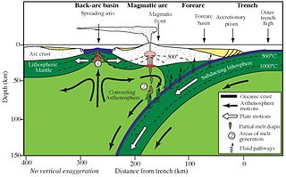
Forearc is a plate tectonic term referring to a region in a subduction zone between an oceanic trench and the associated volcanic arc. Forearc regions are present along convergent margins and eponymously form 'in front of' the volcanic arcs that are characteristic of convergent plate margins. A back-arc region is the companion region behind the volcanic arc.

<span class="mw-page-title-main">Submarine canyon</span> Steep-sided valley cut into the seabed of the continental slope

A submarine canyon is a steep-sided valley cut into the seabed of the continental slope, sometimes extending well onto the continental shelf, having nearly vertical walls, and occasionally having canyon wall heights of up to 5 km (3 mi), from canyon floor to canyon rim, as with the Great Bahama Canyon. Just as above-sea-level canyons serve as channels for the flow of water across land, submarine canyons serve as channels for the flow of turbidity currents across the seafloor. Turbidity currents are flows of dense, sediment laden waters that are supplied by rivers, or generated on the seabed by storms, submarine landslides, earthquakes, and other soil disturbances. Turbidity currents travel down slope at great speed, eroding the continental slope and finally depositing sediment onto the abyssal plain, where the particles settle out.

<span class="mw-page-title-main">Turbidity current</span> An underwater current of usually rapidly moving, sediment-laden water moving down a slope

A turbidity current is most typically an underwater current of usually rapidly moving, sediment-laden water moving down a slope; although current research (2018) indicates that water-saturated sediment may be the primary actor in the process. Turbidity currents can also occur in other fluids besides water.

<span class="mw-page-title-main">Bouma sequence</span> Set of structures in sediments or sedimentary rocks

The Bouma sequence describes a classic set of sedimentary structures in turbidite beds deposited by turbidity currents at the bottoms of lakes, oceans and rivers.

<span class="mw-page-title-main">Graded bedding</span> Type of layering in sediment or sedimentary rock

In geology, a graded bed is a bed characterized by a systematic change in grain or clast size from bottom to top of the bed. Most commonly this takes the form of normal grading, with coarser sediments at the base, which grade upward into progressively finer ones. Such a bed is also described as fining upward. Normally graded beds generally represent depositional environments which decrease in transport energy as time passes, but these beds can also form during rapid depositional events. They are perhaps best represented in turbidite strata, where they indicate a sudden strong current that deposits heavy, coarse sediments first, with finer ones following as the current weakens. They can also form in terrestrial stream deposits.

<span class="mw-page-title-main">Abyssal fan</span> Underwater geological structures associated with large-scale sediment deposition

Abyssal fans, also known as deep-sea fans, underwater deltas, and submarine fans, are underwater geological structures associated with large-scale sediment deposition and formed by turbidity currents. They can be thought of as an underwater version of alluvial fans and can vary dramatically in size, with widths from several kilometres to several thousands of kilometres. The largest is the Bengal Fan, followed by the Indus Fan, but major fans are also found at the outlet of the Amazon, Congo, Mississippi and elsewhere.

<span class="mw-page-title-main">Marine sediment</span>

Marine sediment, or ocean sediment, or seafloor sediment, are deposits of insoluble particles that have accumulated on the seafloor. These particles either have their origins in soil and rocks and have been transported from the land to the sea, mainly by rivers but also by dust carried by wind and by the flow of glaciers into the sea, or they are biogenic deposits from marine organisms or from chemical precipitation in seawater, as well as from underwater volcanoes and meteorite debris.

Abyssal channels are channels in Earth's sea floor. They are formed by fast-flowing floods of turbid water caused by avalanches near the channel's head, with the sediment carried by the water causing a build-up of the surrounding abyssal plains. Submarine channels and the turbidite systems which form them are responsible for the accumulation of most sandstone deposits found on continental slopes and have proven to be one of the most common types of hydrocarbon reservoirs found in these regions.

Hemipelagic sediment, or hemipelagite, is a type of marine sediment that consists of clay and silt-sized grains that are terrigenous and some biogenic material derived from the landmass nearest the deposits or from organisms living in the water. Hemipelagic sediments are deposited on continental shelves and continental rises, and differ from pelagic sediment compositionally. Pelagic sediment is composed of primarily biogenic material from organisms living in the water column or on the seafloor and contains little to no terrigenous material. Terrigenous material includes minerals from the lithosphere like feldspar or quartz. Volcanism on land, wind blown sediments as well as particulates discharged from rivers can contribute to Hemipelagic deposits. These deposits can be used to qualify climatic changes and identify changes in sediment provenances.

<span class="mw-page-title-main">Sediment gravity flow</span> Sediment transport mechanism

A sediment gravity flow is one of several types of sediment transport mechanisms, of which most geologists recognize four principal processes. These flows are differentiated by their dominant sediment support mechanisms, which can be difficult to distinguish as flows can be in transition from one type to the next as they evolve downslope.

<span class="mw-page-title-main">Congo Canyon</span> African submarine canyon at the end of the Congo River

Congo Canyon is a submarine canyon found at the end of the Congo River in Africa. It is one of the largest submarine canyons in the world.

<span class="mw-page-title-main">Geological history of Borneo</span>

The base of rocks that underlie Borneo, an island in Southeast Asia, was formed by the arc-continent collisions, continent–continent collisions and subduction–accretion due to convergence between the Asian, India–Australia, and Philippine Sea-Pacific plates over the last 400 million years. The active geological processes of Borneo are mild as all of the volcanoes are extinct. The geological forces shaping SE Asia today are from three plate boundaries: the collisional zone in Sulawesi southeast of Borneo, the Java-Sumatra subduction boundary and the India-Eurasia continental collision.

Cascadia Channel is the most extensive deep-sea channel currently known of the Pacific Ocean. It extends across Cascadia Abyssal Plain, through the Blanco Fracture Zone, and into Tufts Abyssal Plain. Notably, Cascadia Channel has tributaries, akin to river tributaries.

<span class="mw-page-title-main">Indus Fan</span> Depositional feature of the Indus river

The Indus Fan is one of the most significant depositional feature of the offshore Indus basin. It is the second largest fan system in the world after the Bengal Fan between India, Bangladesh and the Andaman Islands. The Indus fan was deposited in an unconfined setting on the continental slope, rise and basin floor, covering much of the Arabian Sea. The entire fan extends over an area of 110,000 square kilometers with greater than 9 km of sediment accumulating near the toe-of-slope.

Cyclic steps are rhythmic bedforms associated with Froude super-critical flow instability. They are a type of sediment wave, and are created when supercritical sediment-laden water travels downslope through sediment beds. Each ‘step’ has a steep drop, and together they tend to migrate upstream. On the ocean floor, this phenomenon was first shown to be possible in 2006, although it was observed in open-channel flows over a decade earlier. Geological features appearing to be submarine cyclic steps have been detected in the northern lowlands of Mars in the Aeolis Mensae region, providing evidence of an ancient Martian ocean.

The term contour currents was first introduced by Heezen et al in 1966 as bottom currents along the continental shelf driven by Coriolis effects and temperature/salinity dependent density gradients. Generally, the currents flow along depth contours, hence called contour currents. Sediments deposited and shaped by the contour currents are called contourites, which are commonly observed in continental rise.

References

  1. 1 2 3 4 Hollister, C.D. (1993). "The concept of deep-sea contourites". Sedimentary Geology . 82 (1–4): 5–11. Bibcode:1993SedG...82....5H. doi:10.1016/0037-0738(93)90109-I.
  2. 1 2 3 4 Rebesco, M. & Camerlenghi, A. 2008. Contourites, Elsevier Science, 688pp. ISBN   978-0-444-52998-5
  3. 1 2 3 4 5 6 7 8 9 10 11 12 13 14 15 Faugères, J.-C.; Mézerais, M.L.; Stow, D.A.V (1993). "Contourite drift types and their distribution in the North and South Atlantic Ocean basins". Sedimentary Geology. 8 (1–4): 189–203. Bibcode:1993SedG...82..189F. doi:10.1016/0037-0738(93)90121-k.
  4. 1 2 Heezen, B.C.; Hollister, C.D.; Ruddiman, W.F. (1966). "Shaping of the continental rise by deep geostrophic contour currents". Science. 152 (3721): 502–508. Bibcode:1966Sci...152..502H. doi:10.1126/science.152.3721.502. PMID   17815077. S2CID   29313948.
  5. Hollister, C.D.; Heezen, B.C. (1972). "Geologic effects of ocean bottom-currents: western north Atlantic". In: Studies in Physical Oceanography. 2: 37–66.
  6. 1 2 3 4 Faugères, J.-C.; Stow, D.A.V (1993). "Bottom-current-controlled sedimentation: a synthesis of the contourite problem". Sedimentary Geology. 82 (1–4): 287–297. Bibcode:1993SedG...82..287F. doi:10.1016/0037-0738(93)90127-Q.
  7. 1 2 3 IODP Expedition 339 Scientists (2012). "Mediterranean outflow: environmental significance of the Mediterranean Outflow Water and its global implications". IODP Preliminary Report. 339. doi: 10.2204/iodp.pr.339.2012 .{{cite journal}}: CS1 maint: numeric names: authors list (link)
  8. Sam Boggs Jr. (2006). "Ch. 2: Transport and Deposition of Siliciclastic Sediment". Principles of Sedimentology and Stratigraphy. Prentice Hall. pp. 30–31. ISBN   0-13-154728-3.
  9. Miller, M.C.; McCave, I.N.; Komar, P.D. (1977). "Threshold of sediment motion under unidirectional currents". Sedimentology. 24 (4): 507–527. Bibcode:1977Sedim..24..507M. doi:10.1111/j.1365-3091.1977.tb00136.x.
  10. 1 2 3 Hollister, C.D.; McCave, I.N. (1984). "Sedimentation under deep-sea storms". Nature. 309 (5965): 220–225. Bibcode:1984Natur.309..220H. doi:10.1038/309220a0. S2CID   4365998.
  11. Damuth, J.E.; Olson, H.C. (2001). "Neogene-Quaternary contourite and related deposition on the West Shetland Slope and Faeroe-Shetland Channel revealed by high-resolution seismic studies". Marine Geophysical Researches. 22 (5/6): 369–399. doi:10.1023/A:1016395515456. S2CID   14555444.
  12. G. Shanmugam (2006). "Ch. 4: Deep-water bottom currents". Deepwater Processes and Facies Models: Implications for Sandstone Petroleum Reservoirs. Elsevier Science. pp. 85–139. ISBN   0-444-52161-5.
  13. Gonthier, E.G.; Faugères, J.-C. (1984). "Contourite facies of the Faro Drift, Gulf of Cadiz". In: "Fine-Grained Sediments: Deep-Water Processes and Facies", Geological Society of London Special Publication. 15 (1): 275–292. Bibcode:1984GSLSP..15..275G. doi:10.1144/gsl.sp.1984.015.01.18. S2CID   129494147.
  14. Stow, D.A.V.; Hernandez-Molina, F.J.; Llave, E.; Sayago-Gil, M.; Diaz del Rio, V.; Branson, A. (2009). "Bedform-velocity matrix: The estimation of bottom current velocity from bedform observations". Geology. 37 (4): 327–330. Bibcode:2009Geo....37..327S. doi:10.1130/g25259a.1.
  15. 1 2 3 4 5 6 7 8 9 Stow, D.A.V.; Faugères, J.-C.; Pudsey, C.J.; Viana, A.R. (2002). "Bottom currents, contourites and deep-sea sediment drifts: current state-of-the-art". In: "Deep-Water Contourite Systems: Modern Drifts and Ancient Series, Seismic and Sedimentary Characteristics", Geological Society of London, Memoirs. 22: 7–20. doi:10.1144/gsl.mem.2002.022.01.02. S2CID   128678734.
  16. Damuth, J.E.; Olson, H.C. (2001). "Neogene-Quaternary contourite and related deposition on the West Shetland Slope and Faeroe-Shetland Channel revealed by high-resolution seismic studies". Marine Geophysical Researches. 22 (5/6): 363–398. Bibcode:2001MarGR..22..369D. doi:10.1023/A:1016395515456. S2CID   14555444.
  17. 1 2 Stanley, D.J. (1993). "Model for turbidite-to-contourite continuum and multiple process transport in deep marine settings: examples in the rock record". Sedimentary Geology. 82 (1–4): 241–255. Bibcode:1993SedG...82..241S. doi:10.1016/0037-0738(93)90124-N.
  18. Shanmugam, G. (1993). "Traction structures in deep-marine, bottom-current reworked sands in the Pliocene and Pleistocene, Gulf of Mexico". Geology. 21 (10): 929–932. Bibcode:1993Geo....21..929S. doi:10.1130/0091-7613(1993)021<0929:TSIDMB>2.3.CO;2.
  19. Dalrymple, R.W.; Narbonne, G.M. (1996). "Continental slope sedimentation in the Sheepbed Formation (Neoproterozoic, Windermere Supergroup), Mackenzie Mountains, N.W.T.". Canadian Journal of Earth Sciences. 33 (6): 848–862. Bibcode:1996CaJES..33..848D. doi:10.1139/e96-064.