The pelagic zone consists of the water column of the open ocean and can be further divided into regions by depth. The word pelagic is derived from Ancient Greek πέλαγος (pélagos) 'open sea'. The pelagic zone can be thought of as an imaginary cylinder or water column between the surface of the sea and the bottom. Conditions in the water column change with depth: pressure increases; temperature and light decrease; salinity, oxygen, micronutrients all change. Somewhat analogous to stratification in the Earth's atmosphere, but depending on how deep the water is, the water column can be divided vertically into up to five different layers.

A thermocline is a distinct layer based on temperature within a large body of fluid with a high gradient of distinct temperature differences associated with depth. In the ocean, the thermocline divides the upper mixed layer from the calm deep water below.
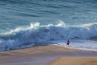
In fluid dynamics, a wind wave, or wind-generated water wave, is a surface wave that occurs on the free surface of bodies of water as a result of the wind blowing over the water's surface. The contact distance in the direction of the wind is known as the fetch. Waves in the oceans can travel thousands of kilometers before reaching land. Wind waves on Earth range in size from small ripples to waves over 30 m (100 ft) high, being limited by wind speed, duration, fetch, and water depth.
Upper Shoreface refers to the portion of the seafloor that is shallow enough to be agitated by everyday wave action, the wave base.
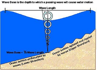
Lower Shoreface refers to the portion of the seafloor, and the sedimentary depositional environment, that lies below the everyday wave base.

The benthic zone is the ecological region at the lowest level of a body of water such as an ocean, lake, or stream, including the sediment surface and some sub-surface layers. The name comes from ancient Greek, βένθος (bénthos), meaning "the depths." Organisms living in this zone are called benthos and include microorganisms as well as larger invertebrates, such as crustaceans and polychaetes. Organisms here generally live in close relationship with the substrate and many are permanently attached to the bottom. The benthic boundary layer, which includes the bottom layer of water and the uppermost layer of sediment directly influenced by the overlying water, is an integral part of the benthic zone, as it greatly influences the biological activity that takes place there. Examples of contact soil layers include sand bottoms, rocky outcrops, coral, and bay mud.

Bathymetry is the study of underwater depth of ocean floors, lake floors, or river floors. In other words, bathymetry is the underwater equivalent to hypsometry or topography. The first recorded evidence of water depth measurements are from Ancient Egypt over 3000 years ago. Bathymetric charts, are typically produced to support safety of surface or sub-surface navigation, and usually show seafloor relief or terrain as contour lines and selected depths (soundings), and typically also provide surface navigational information. Bathymetric maps may also use a Digital Terrain Model and artificial illumination techniques to illustrate the depths being portrayed. The global bathymetry is sometimes combined with topography data to yield a global relief model. Paleobathymetry is the study of past underwater depths.
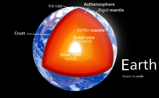
Earth's mantle is a layer of silicate rock between the crust and the outer core. It has a mass of 4.01×1024 kg (8.84×1024 lb) and thus makes up 67% of the mass of Earth. It has a thickness of 2,900 kilometers (1,800 mi) making up about 46% of Earth's radius and 84% of Earth's volume. It is predominantly solid but, on geologic time scales, it behaves as a viscous fluid, sometimes described as having the consistency of caramel. Partial melting of the mantle at mid-ocean ridges produces oceanic crust, and partial melting of the mantle at subduction zones produces continental crust.

The seabed is the bottom of the ocean. All floors of the ocean are known as 'seabeds'.
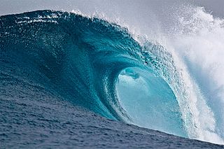
In fluid dynamics and nautical terminology, a breaking wave or breaker is a wave with enough energy to "break" at its peak, reaching a critical level at which linear energy transforms into wave turbulence energy with a distinct forward curve. At this point, simple physical models that describe wave dynamics often become invalid, particularly those that assume linear behaviour.

In geology, depositional environment or sedimentary environment describes the combination of physical, chemical, and biological processes associated with the deposition of a particular type of sediment and, therefore, the rock types that will be formed after lithification, if the sediment is preserved in the rock record. In most cases, the environments associated with particular rock types or associations of rock types can be matched to existing analogues. However, the further back in geological time sediments were deposited, the more likely that direct modern analogues are not available.
Subsea technology involves fully submerged ocean equipment, operations, or applications, especially when some distance offshore, in deep ocean waters, or on the seabed. The term subsea is frequently used in connection with oceanography, marine or ocean engineering, ocean exploration, remotely operated vehicle (ROVs) autonomous underwater vehicles (AUVs), submarine communications or power cables, seafloor mineral mining, oil and gas, and offshore wind power.

Marine sediment, or ocean sediment, or seafloor sediment, are deposits of insoluble particles that have accumulated on the seafloor. These particles have their origins in soil and rocks and have been transported from the land to the sea, mainly by rivers but also by dust carried by wind and by the flow of glaciers into the sea. Additional deposits come from marine organisms and chemical precipitation in seawater, as well as from underwater volcanoes and meteorite debris.
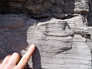
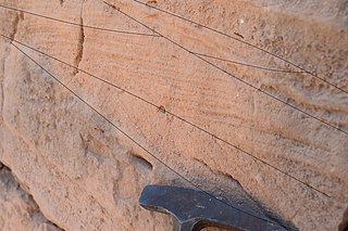
Hummocky cross-stratification is a type of sedimentary structure found in sandstones. It is a form of cross-bedding usually formed by the action of large storms, such as hurricanes. It takes the form of a series of "smile"-like shapes, crosscutting each other. It is only formed at a depth of water below fair-weather wave base and above storm-weather wave base. They are not related to "hummocks" except in shape.
In fluid dynamics, Airy wave theory gives a linearised description of the propagation of gravity waves on the surface of a homogeneous fluid layer. The theory assumes that the fluid layer has a uniform mean depth, and that the fluid flow is inviscid, incompressible and irrotational. This theory was first published, in correct form, by George Biddell Airy in the 19th century.

A deep-sea community is any community of organisms associated by a shared habitat in the deep sea. Deep sea communities remain largely unexplored, due to the technological and logistical challenges and expense involved in visiting this remote biome. Because of the unique challenges, it was long believed that little life existed in this hostile environment. Since the 19th century however, research has demonstrated that significant biodiversity exists in the deep sea.

A marine habitat is a habitat that supports marine life. Marine life depends in some way on the saltwater that is in the sea. A habitat is an ecological or environmental area inhabited by one or more living species. The marine environment supports many kinds of these habitats.
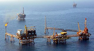
Offshore geotechnical engineering is a sub-field of geotechnical engineering. It is concerned with foundation design, construction, maintenance and decommissioning for human-made structures in the sea. Oil platforms, artificial islands and submarine pipelines are examples of such structures. The seabed has to be able to withstand the weight of these structures and the applied loads. Geohazards must also be taken into account. The need for offshore developments stems from a gradual depletion of hydrocarbon reserves onshore or near the coastlines, as new fields are being developed at greater distances offshore and in deeper water, with a corresponding adaptation of the offshore site investigations. Today, there are more than 7,000 offshore platforms operating at a water depth up to and exceeding 2000 m. A typical field development extends over tens of square kilometers, and may comprise several fixed structures, infield flowlines with an export pipeline either to the shoreline or connected to a regional trunkline.
The upper mantle of Earth is a very thick layer of rock inside the planet, which begins just beneath the crust and ends at the top of the lower mantle at 670 km (420 mi). Temperatures range from approximately 500 K at the upper boundary with the crust to approximately 1,200 K at the boundary with the lower mantle. Upper mantle material that has come up onto the surface comprises about 55% olivine, 35% pyroxene, and 5 to 10% of calcium oxide and aluminum oxide minerals such as plagioclase, spinel, or garnet, depending upon depth.


