Scotia Plate

Last updated
Scotia Plate
ScotiaPlate.png
Type Minor
Approximate area1,651,000 km2 (637,000 sq mi) [1]
Movement1West
Speed125mm/year
Features Drake Passage, Scotia Sea, and South Georgia
1Relative to the African Plate

The Scotia Plate (Spanish : Placa Scotia) is a minor tectonic plate on the edge of the South Atlantic and Southern oceans. Thought to have formed during the early Eocene with the opening of the Drake Passage that separates Antarctica and South America, [2] it is a minor plate whose movement is largely controlled by the two major plates that surround it: the Antarctic Plate and the South American Plate. [3] The Scotia Plate takes its name from the steam yacht Scotia of the Scottish National Antarctic Expedition (1902–04), the expedition that made the first bathymetric study of the region. [4]

Contents

Roughly rhomboid, extending between 50°S70°W / 50°S 70°W / -50; -70 and 63°S20°W / 63°S 20°W / -63; -20 , the plate is 800 km (500 mi) wide and 3,000 km (1,900 mi) long. It is moving WSW at 2.2 cm (0.87 in)/year and the South Sandwich Plate is moving east at 5.5 cm (2.2 in)/year in an absolute reference frame. [5] Its boundaries are defined by the East Scotia Ridge, the North Scotia Ridge, the South Scotia Ridge, and the Shackleton Fracture Zone. [6]

The Scotia Plate is made of oceanic crust and continental fragments now distributed around the Scotia Sea. Before the formation of the plate began 40  million years ago (40Ma), these fragments formed a continuous landmass from Patagonia to the Antarctic Peninsula along an active subduction margin. [5] At present, the plate is almost completely submerged, with only the small exceptions of South Georgia on its northeastern edge and the southern tip of South America. [7]

Tectonic setting

Bathymetric map of Scotia Plate Scotia Sea NOAA.jpg
Bathymetric map of Scotia Plate
The Scotia Plate (SCO) bounded by the Antarctic Plate (ANT), the South Sandwich Plate (SAN), the South American Plate (SAM), and the Shetland Plate, seen just above the Antarctic Peninsula (AP). East Scotia Ridge vents map.png
The Scotia Plate (SCO) bounded by the Antarctic Plate (ANT), the South Sandwich Plate (SAN), the South American Plate (SAM), and the Shetland Plate, seen just above the Antarctic Peninsula (AP).

Together with the Sandwich Plate, the Scotia Plate joins the southernmost Andes to the Antarctic Peninsula, just like the Caribbean Plate joins the northernmost Andes to North America, and these two plates are comparable in several ways. Both have volcanic arcs at their eastern ends, the South Sandwich Islands on the Sandwich Plate and the Lesser Antilles on the Caribbean Plate, and both plates also had a major impact on global climate when they closed the two major gateways between the Pacific and Atlantic Oceans during the Mesozoic and Cenozoic. [4]

North Scotia Ridge

The northern edge of the Scotia Plate is bounded by the South American Plate, forming the North Scotia Ridge. The North Scotia ridge is a left-lateral, or sinistral, transform boundary with a transform rate of roughly 7.1 mm/yr. [8] The Magallanes–Fagnano Fault is passing through Tierra del Fuego.

The northern ridge stretches from Isla de los Estados off Tierra del Fuego in the west to the microcontinent South Georgia in the east, with a series of shallow banks in between: Burdwood, Davis, Barker, and Shag Rocks. North of the ridge is the 3 km (1.9 mi) deep Falkland Trough. [9]

South Georgia microcontinent

Experts in plate tectonics have been unable to determine whether the South Georgian Islands are part of the Scotia Plate or have been recently accreted to the South American Plate. Surface expressions of the plate boundary are found north of the islands suggesting a long-term presence of the transform fault there. Yet seismic studies have identified strain and thrusting south of the islands indicating the possible shift of the transform fault to an area south of the island. It has also been suggested that the plate bearing the islands may have broken off from the Scotia Plate, forming a new independent South Georgia microplate, yet there is little evidence to make this conclusion. [10]

The South Georgia microcontinent was originally connected to the Roca Verdes back-arc basin (southernmost Tierra del Fuego) until the Eocene. Before that, this basin went through a series of geological transformations during the Cretaceous, through which South Georgia was first buried, then made a topographic feature again by the Late Cretaceous. At about 45 Ma, South Georgia, still part of the South American Plate, got buried again and something, possibly rotation of the Fuegian Andes, completed the break-up and allowed South Georgia a second exhumation. During the Oligocene (34–23 Ma) South Georgia was reburied again as seafloor spreading took place in the West Scotia Sea. 10 Ma, finally, the South Georgia microcontinent was uplifted as a result of the collision with the Northeast Georgia Rise. [11]

South Scotia Ridge

The southern edge of the plate is bordered by the Antarctic Plate, forming the South Scotia Ridge, a left-lateral transform boundary sliding at a rate of roughly 7.4–9.5 mm/yr that occupies the southern half of the Antarctic-Scotia plate boundary. [8] The relative motion between the Scotia Plate and the Antarctic Plate on the western boundary is 7.5–8.7 mm/yr. [8] Though the South Scotia Ridge is overall a transform fault, small sections of the ridge are spreading to make up for the somewhat jagged shape of the boundary. [7]

At the eastern tip of the Antarctic Peninsula, the beginning of South Scotia Ridge, a small and heavily dissected bank degenerates into several outcrops dominated by Paleozoic and Cretaceous rocks. A small basin, Powel Basin, separates this cluster from the South Orkney microcontinent composed of Triassic and younger rocks.

The eastern continuation of the ridge, the Scotia Arc east of the South Sandwich Plate, are the South Sandwich island arc and trench. This volcanic active island arc has submerged ancestors in Jane and Discovery banks in the southern ridge. [9]

Shackleton Fracture Zone

The western edge of the plate is bounded by the Antarctic Plate, forming the Shackleton Fracture Zone and the southern Chile Trench. The Southern Chile Trench is a southern extension of the subduction of the Antarctic and Nazca plates below South America. Heading south along the ridge, the subduction rate decreases until its remaining oblique motion evolves into the Shackleton Fracture Zone transform boundary. The south-western edge of the plate is bounded by the Shetland microplate separating the Shackleton Fracture Zone and the South Scotia Ridge. [7]

North of South Shetland Islands and along the southern half of the Shackleton Fracture Zone is the remnant of the Phoenix Plate (also known as Drake or Aluk Plate). Around 47 Ma the subduction of the Phoenix Plate started as the propagation of the Pacific-Antarctic Ridge continued. The last collision between Phoenix ridge segments and the subduction zone was 6.5 Ma and at 3.3 Ma movements had stopped and the remnants of the Phoenix Plate was incorporated into the Antarctic Plate. The southern part of the Shackleton Fracture Zone is the former eastern edge of the Phoenix Plate. [12]

East Scotia Ridge

The eastern edge of the Scotia Plate is a spreading ridge bounded by the South Sandwich microplate, forming the East Scotia Ridge. [13] The East Scotia Ridge is a back-arc spreading ridge that formed due to subduction of the South American Plate below the South Sandwich Plate along the South Sandwich Island arc. Exact spreading rates are still being disputed in the literature, but it has been agreed that rates range between 60 and 90 mm/yr. [14]

The banks of northern Central Scotia Sea are superposed on oceanic basement and the spreading centre of the West Scotia Sea. Analyses of samples of volcaniclastic rocks from these sites indicate they are constructs of a continental arc and in some cases oceanic arc similar to those being formed in the currently active South Sandwich Arc. The oldest volcanic arc activity in the central and eastern regions of the Scotia Sea are 28.5 Ma. The South Sandwich forarc originated in the Central Scotia Sea at that time but has since been translated eastward by the back-arc spreading centre of the East Scotia Ridge. [15]

West Scotia Ridge

One of the most prominent features in the Scotia Plate itself is the median valley known as the West Scotia Ridge. It was produced by two plates that are no longer independently active: the Magallanes and Central Scotia Plates so is an extinct spreading center. [16] The ridge consists of seven segments separated by right-lateral transform faults of various lengths. [16] The western region of the Scotia Plate can be dated to 26–5.5 Ma suggesting spreading was active before spreading completely translated to the East Scotia Ridge at about 6 Ma. [16] It was assumed that spreading cessation occurred where the W7 segment joins the North Scotia Ridge. [16] However basalt lava sampled from the eastern side of the W7 segment were found to be between 93 to 137 million years old and the geochemistry of arc-like basalts suggests no sea floor spreading actually occurred in the W7 segment itself. [17] This has resulted in the suggestion that the W7 segment is a downfaulted block of the North Scotia Ridge of the Fuegian Andes continental margin arc, or is potentially related to the putative Cretaceous Central Scotia Sea. [17]

Timeline

The timing of the formation of the Scotia Plate and opening of the Drake Passage have long been the subject of much debate due to the important implications for changes in ocean currents and shifts in paleoclimate. The thermal isolation of Antarctica, engendering the formation of the Antarctic ice sheet, has largely been attributed to the opening of the Drake Passage. [18]

Formation

The Scotia Plate originated about 80  million years ago (Ma), during the late Mesozoic at the Panthalassic margins of the Gondwana supercontinent between two Precambrian cratons, the Kalahari and East Antarctic Cratons, now located in Africa and Antarctica. Its development was also influenced by the Río de la Plata Craton in South America. The initial cause for its formation was the break-up of Gondwana in what became the south-west Indian Ocean. [4]

The earliest marine fossils found on the Maurice Ewing Bank, on the eastern end of the Falkland Plateau, are associated with the Indian and Tethys Oceans and probably slightly more than 150 Ma. The Weddell Sea opened and spread along the southern margin of the Falkland Plateau and into the Rocas Verdes back-arc basin which extends from South Georgia and along the Patagonian Andes. Fragments of the inverted oceanic basement of this basin are preserved as ophiolitic complexes in this area, including the Larsen Harbour complex on South Georgia. This makes it possible to restore the original position of the South Georgia microcontinent south of the Burdwood Bank on the western North Scotia Ridge south of the Falkland Islands. [19]

The Rocas Verdes basin was filled with turbidites derived from the volcanic arc on its Pacific margin and partly from its continental margin. The Weddell Sea continued to expand which led to the extension between the Patagonian Andes and the Antarctic Peninsula. In the Mid-Cretaceous (100 Ma) the spreading rate in South Atlantic increased significantly and the Mid-Atlantic Ridge grew from 1200 km to 7000 km. This led to compressional deformations along the western margin of the South American Plate and the obduction of the Rocas Verdes basement onto this margin. Structures associated with this obduction are found from Tierra del Fuego to South Georgia. [20] The acceleration of the westward motion of South America and the inversion of the Rocas Verde Basin finally lead to the initiation of the Scotia Arc. This inversion had a strike-slip component which can be seen in the Cooper Bay dislocation on South Georgia. This geological regime lead to the uplift and elongation of the Andes and the embryonic North Scotia Ridge, which resulted in the initial eastward relocation of the South Georgia microcontinent and formation of the Central Scotia Sea. [21]

Opening of Drake Passage

Between the Late Cretaceous and the Early Oligocene (90–30 Ma) little changed in the region, except for the subduction of the Phoenix Plate along the Shackleton Fracture Zone. The Late Paleocene and Early Eocene (60–50 Ma) saw the formation of South Scotia Sea and South Scotia Ridge — the first sign of separation of the southern Andes and the Antarctic Peninsula — which resulted in seafloor spreading in the West Scotia Sea and hence the initial opening of a deep Drake Passage. The ongoing lengthening of the North Scotia Ridge beyond the Burdwood Bank caused South Georgia to move further east. The banks of the North Scotia Ridge contain volcanic rocks similar to those found in Tierra del Fuego, including on Isla de los Estados on the easternmost tip. [22]

During the early Eocene (50 Ma), the Drake Passage between the southern tip of South America at Cape Horn and the South Shetland Islands of Antarctica was a small opening with limited circulation. A change in relative motion between the South American Plate and the Antarctic Plate would have severe effects, causing seafloor spreading and the formation of the Scotia Plate. [23] Marine geophysical data indicates that motion between the South American Plate and the Antarctic Plate shifted from N-S to WNW-ESE accompanied by an eightfold increase in the separation rate. This shift in spreading initiated crustal thinning and by 30–34 Ma, the West Scotia Ridge formed. [24]

A complex pattern of spreading prior to 26 Ma is probably present in the oldest parts of this spreading regime; i.e. west of Terror Rise (north of Elephant Island) and on the shelf slope of Tierra del Fuego. Until 17 Ma the Central Scotia Plate moved quickly eastwards, fuelled by the eastern trench migration, but both plates have moved very slowly since. [25]

Related Research Articles

<span class="mw-page-title-main">Nazca Plate</span> Oceanic tectonic plate in the eastern Pacific Ocean basin

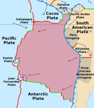
The Nazca Plate or Nasca Plate, named after the Nazca region of southern Peru, is an oceanic tectonic plate in the eastern Pacific Ocean basin off the west coast of South America. The ongoing subduction, along the Peru–Chile Trench, of the Nazca Plate under the South American Plate is largely responsible for the Andean orogeny. The Nazca Plate is bounded on the west by the Pacific Plate and to the south by the Antarctic Plate through the East Pacific Rise and the Chile Rise respectively. The movement of the Nazca Plate over several hotspots has created some volcanic islands as well as east–west running seamount chains that subduct under South America. Nazca is a relatively young plate both in terms of the age of its rocks and its existence as an independent plate having been formed from the break-up of the Farallon Plate about 23 million years ago. The oldest rocks of the plate are about 50 million years old.

<span class="mw-page-title-main">Scotia Sea</span> Sea in the Southern Ocean

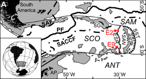
The Scotia Sea is a sea located at the northern edge of the Southern Ocean at its boundary with the South Atlantic Ocean. It is bounded on the west by the Drake Passage and on the north, east, and south by the Scotia Arc, an undersea ridge and island arc system supporting various islands. The sea sits atop the Scotia Plate. It is named after the expedition ship Scotia. Many icebergs melt there.

<span class="mw-page-title-main">Kerguelen Plateau</span> Oceanic plateau in the southern Indian Ocean

The Kerguelen Plateau, also known as the Kerguelen–Heard Plateau, is an oceanic plateau and large igneous province (LIP) located on the Antarctic Plate, in the southern Indian Ocean. It is about 3,000 km (1,900 mi) to the southwest of Australia and is nearly three times the size of California. The plateau extends for more than 2,200 km (1,400 mi) in a northwest–southeast direction and lies in deep water.

<span class="mw-page-title-main">Protector Shoal</span> Submarine volcano NW of Zavodovski Island in the South Sandwich Islands

Protector Shoal is the shallowest point of the Protector Seamounts, a group of submarine volcanoes in the Southern Ocean. They are part of the South Sandwich island arc, a volcanic arc that has given rise to the South Sandwich Islands. Protector Shoal reaches a depth of 55 metres (180 ft) below sea level and is part of a larger group of seamounts that formed atop a larger ridge. Some of these seamounts bear traces of sector collapses, and one is capped by nested calderas.

<span class="mw-page-title-main">Caledonian orogeny</span> Mountain building event caused by the collision of Laurentia, Baltica and Avalonia

The Caledonian orogeny was a mountain-building cycle recorded in the northern parts of the British Isles, the Scandinavian Caledonides, Svalbard, eastern Greenland and parts of north-central Europe. The Caledonian orogeny encompasses events that occurred from the Ordovician to Early Devonian, roughly 490–390 million years ago (Ma). It was caused by the closure of the Iapetus Ocean when the Laurentia and Baltica continents and the Avalonia microcontinent collided.

<span class="mw-page-title-main">Phoenix Plate</span> Tectonic plate that existed during the early Paleozoic through late Cenozoic time

The Phoenix Plate was a tectonic plate that existed during the early Paleozoic through late Cenozoic time. It formed a triple junction with the Izanagi and Farallon plates in the Panthalassa Ocean as early as 410 million years ago, during which time the Phoenix Plate was subducting under eastern Gondwana.

<span class="mw-page-title-main">Back-arc basin</span> Submarine features associated with island arcs and subduction zones

A back-arc basin is a type of geologic basin, found at some convergent plate boundaries. Presently all back-arc basins are submarine features associated with island arcs and subduction zones, with many found in the western Pacific Ocean. Most of them result from tensional forces, caused by a process known as oceanic trench rollback, where a subduction zone moves towards the subducting plate. Back-arc basins were initially an unexpected phenomenon in plate tectonics, as convergent boundaries were expected to universally be zones of compression. However, in 1970, Dan Karig published a model of back-arc basins consistent with plate tectonics.

<span class="mw-page-title-main">Cimmeria (continent)</span> Ancient string of microcontinents that rifted from Gondwana

Cimmeria was an ancient continent, or, rather, a string of microcontinents or terranes, that rifted from Gondwana in the Southern Hemisphere and was accreted to Eurasia in the Northern Hemisphere. It consisted of parts of present-day Turkey, Iran, Afghanistan, Pakistan, Tibet, China, Myanmar, Thailand, and Malaysia. Cimmeria rifted from the Gondwanan shores of the Paleo-Tethys Ocean during the Early Permian and as the Neo-Tethys Ocean opened behind it, during the Permian, the Paleo-Tethys closed in front of it. Because the different chunks of Cimmeria drifted northward at different rates, a Meso-Tethys Ocean formed between the different fragments during the Cisuralian. Cimmeria rifted off Gondwana from east to west, from Australia to the eastern Mediterranean. It stretched across several latitudes and spanned a wide range of climatic zones.

<span class="mw-page-title-main">Izu–Bonin–Mariana Arc</span> Convergent boundary in Micronesia

The Izu–Bonin–Mariana (IBM) arc system is a tectonic plate convergent boundary in Micronesia. The IBM arc system extends over 2800 km south from Tokyo, Japan, to beyond Guam, and includes the Izu Islands, the Bonin Islands, and the Mariana Islands; much more of the IBM arc system is submerged below sealevel. The IBM arc system lies along the eastern margin of the Philippine Sea Plate in the Western Pacific Ocean. It is the site of the deepest gash in Earth's solid surface, the Challenger Deep in the Mariana Trench.

<span class="mw-page-title-main">Scotia Arc</span> Island arc system in the Southern Ocean

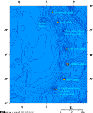
The Scotia Arc is the island arc system forming the north, east and south border of the Scotia Sea. The northern border, the North Scotia Ridge, comprises Isla de los Estados at the tip of Tierra del Fuego, the Burdwood, Davis, and Aurora Banks; the Shag, South Georgia Island and Clerke Rocks. The eastern border comprises the volcanic South Sandwich Islands flanked by the South Sandwich Trench. The southern border, the South Scotia Ridge, comprises Herdman, Discovery, Bruce, Pirie, and Jane Banks; the South Orkney Islands and Elephant Island. The Bransfield Strait, finally, separates the arc from the South Shetland Islands and James Ross Island flanking the tip of the Antarctic Peninsula.

<span class="mw-page-title-main">South American–Antarctic Ridge</span> Mid-ocean ridge in the South Atlantic between the South American Plate and the Antarctic Plate

The South American–Antarctic Ridge or simply American-Antarctic Ridge is the tectonic spreading center between the South American Plate and the Antarctic Plate. It runs along the sea-floor from the Bouvet Triple Junction in the South Atlantic Ocean south-westward to a major transform fault boundary east of the South Sandwich Islands. Near the Bouvet Triple Junction the spreading half rate is 9 mm/a (0.35 in/year), which is slow, and the SAAR has the rough topography characteristic of slow-spreading ridges.

<span class="mw-page-title-main">Chile Triple Junction</span> Place where the South American, Nazca and Antarctic tectonic plates meet

The Chile Triple Junction is a geologic triple junction located on the seafloor of the Pacific Ocean off Taitao and Tres Montes Peninsula on the southern coast of Chile. Here three tectonic plates meet: the South American Plate, the Nazca Plate and the Antarctic Plate. This triple junction is unusual in that it consists of a mid-oceanic ridge, the Chile Rise, being subducted under the South American Plate at the Peru–Chile Trench. The Chile Triple Junction is the boundary between the Chilean Rise and the Chilean margin, where the Nazca, Antarctic, and South American plates meet at the trench.

<span class="mw-page-title-main">Gondwana</span> Neoproterozoic to Cretaceous landmass

Gondwana was a large landmass, sometimes referred to as a supercontinent. It was formed by the accretion of several cratons, beginning c. 800 to 650Ma with the East African Orogeny, the collision of India and Madagascar with East Africa, and was completed c.600 to 530 Ma with the overlapping Brasiliano and Kuunga orogenies, the collision of South America with Africa, and the addition of Australia and Antarctica, respectively. Eventually, Gondwana became the largest piece of continental crust of the Palaeozoic Era, covering an area of about 100,000,000 km2 (39,000,000 sq mi), about one-fifth of the Earth's surface. It fused with Euramerica during the Carboniferous to form Pangea. It began to separate from northern Pangea (Laurasia) during the Triassic, and started to fragment during the Early Jurassic. The final stages of break-up, involving the separation of Antarctica from South America and Australia, occurred during the Paleogene (from around 66 to 23 million years ago. Gondwana was not considered a supercontinent by the earliest definition, since the landmasses of Baltica, Laurentia, and Siberia were separated from it. To differentiate it from the Indian region of the same name, it is also commonly called Gondwanaland.

<span class="mw-page-title-main">Shetland Plate</span> Tectonic microplate off the tip of the Antarctic Peninsula

The Shetland Plate, or South Shetland Plate, is a tectonic microplate located off the tip of the Antarctic Peninsula that contains the South Shetland Islands. The plate is bordered on three sides by the Antarctic Plate, while the fourth side is bordered by the Scotia Plate. The northwestern border is defined by the South Shetland Trench, separating the Shetland Plate to the south from the Antarctic Plate to the north. This trench is the remnant of a subduction zone where the defunct Phoenix Plate, now part of the Antarctic Plate, subducted under the Antarctic Peninsula and the Shetland Islands. The southeastern border is a rift zone, with the Antarctic Plate creating the Bransfield Basin. The southwestern and northeastern boundaries are each part of larger fracture zones. The southwestern border is the Hero Fracture Zone and separates the Antarctic Plate to the southwest from the Shetland Plate to the northeast. The northeastern boundary is the Shackleton Fracture Zone and separates the Shetland Plate to the southwest from the Scotia Plate.

This is a list of articles related to plate tectonics and tectonic plates.

<span class="mw-page-title-main">Andean orogeny</span> Ongoing mountain-forming process in South America

The Andean orogeny is an ongoing process of orogeny that began in the Early Jurassic and is responsible for the rise of the Andes mountains. The orogeny is driven by a reactivation of a long-lived subduction system along the western margin of South America. On a continental scale the Cretaceous and Oligocene were periods of re-arrangements in the orogeny. The details of the orogeny vary depending on the segment and the geological period considered.

<span class="mw-page-title-main">Geology of the Pacific Ocean</span> Overview about the geology of the Pacific Ocean

The Pacific Ocean evolved in the Mesozoic from the Panthalassic Ocean, which had formed when Rodinia rifted apart around 750 Ma. The first ocean floor which is part of the current Pacific Plate began 160 Ma to the west of the central Pacific and subsequently developed into the largest oceanic plate on Earth.

<span class="mw-page-title-main">Northeast Georgia Rise</span> Oceanic plateau in the South Atlantic Ocean

The Northeast Georgia Rise is an oceanic plateau located in the South Atlantic Ocean northeast of South Georgia Island and west of the Falkland Plateau.

<span class="mw-page-title-main">Natural delimitation between the Pacific and South Atlantic oceans by the Scotia Arc</span>

The natural delimitation between the Pacific and South Atlantic Oceans by the Scotia arc is the title of a scientific theory developed in Chile in which it was postulated that the boundary between the Southeast Pacific Ocean and the Southwest Atlantic Ocean would not be the meridian of the Cape Horn, but rather the Scotia Arc, an underwater orographic chain which links the Tierra del Fuego archipelago with the Antarctic continent.

References

Notes

  1. "SFT and the Earth's Tectonic Plates". Los Alamos National Laboratory. Archived from the original on 29 July 2015. Retrieved 17 July 2015.
  2. Livermore et al. 2005 , 5. Eocene opening, pp. 465, 467
  3. Livermore et al. 2005 , 2. South America-Antarctica plate tectonics, p. 460
  4. 1 2 3 Dalziel et al. 2013 , The Scotia Arc in space and time, pp. 768–769
  5. 1 2 Giner-Robles et al. 2003 , 2. Geological setting, pp. 179–181
  6. Riley et al. 2019 , P137
  7. 1 2 3 Thomas, Livermore & Pollitz 2003 , [ page needed ]
  8. 1 2 3 Thomas, Livermore & Pollitz 2003 , Fig. 12, p. 802
  9. 1 2 Eagles & Jokat 2014 , 2. Tectonic studies of the Scotia Sea, pp. 29–30
  10. Thomas, Livermore & Pollitz 2003 , 5 Discussion, pp. 802–803
  11. Carter, Curtis & Schwanethal 2014 , Discussion, pp. 301–302; Conclusions, p. 302
  12. Eagles 2003 , 2. Tectonic setting, p. 98
  13. Thomas, Livermore & Pollitz 2003 , 2.2 Spreading rates, p. 796
  14. Livermore 2003
  15. Dalziel et al. 2013 , Development of the Scotia Arc, pp. 779–780
  16. 1 2 3 4 Riley et al. 2019 , p. 136
  17. 1 2 Riley et al. 2019 , pp. 136, 146
  18. Livermore et al. 2005 , 1. Global cooling and Southern Ocean gateways, pp. 459–460
  19. Dalziel et al. 2013 , Separation of West and East Gondwana, p. 773
  20. Dalziel et al. 2013 , Opening of the Atlantic Ocean Basin, pp. 775–776
  21. Dalziel et al. 2013 , Development of the Scotia Arc, pp. 776–777
  22. Dalziel et al. 2013 , Development of the Scotia Arc, pp. 777–778
  23. Pelayo & Wiens 1989
  24. Livermore et al. 2005 , Abstract
  25. Eagles & Jokat 2014 , 2.3.2. West Scotia Sea, p. 33

Sources

57°S46°W / 57°S 46°W / -57; -46