
Plate tectonics is the generally accepted scientific theory that considers the Earth's lithosphere to comprise a number of large tectonic plates which have been slowly moving since about 3.4 billion years ago. The model builds on the concept of continental drift, an idea developed during the first decades of the 20th century. Plate tectonics came to be generally accepted by geoscientists after seafloor spreading was validated in the mid-to-late 1960s.

Orogeny is a mountain building process that takes place at a convergent plate margin when plate motion compresses the margin. An orogenic belt or orogen develops as the compressed plate crumples and is uplifted to form one or more mountain ranges. This involves a series of geological processes collectively called orogenesis. These include both structural deformation of existing continental crust and the creation of new continental crust through volcanism. Magma rising in the orogen carries less dense material upwards while leaving more dense material behind, resulting in compositional differentiation of Earth's lithosphere. A synorogenic process or event is one that occurs during an orogeny.

The Transverse Ranges are a group of mountain ranges of southern California, in the Pacific Coast Ranges physiographic region in North America. The Transverse Ranges begin at the southern end of the California Coast Ranges and lie within Santa Barbara, Ventura, Los Angeles, San Bernardino, Riverside and Kern counties. The Peninsular Ranges lie to the south. The name Transverse Ranges is due to their east–west orientation, making them transverse to the general northwest–southeast orientation of most of California's coastal mountains.

The Alpine orogeny or Alpide orogeny is an orogenic phase in the Late Mesozoic (Eoalpine) and the current Cenozoic that has formed the mountain ranges of the Alpide belt.

The West Indies is a subregion of North America, surrounded by the North Atlantic Ocean and the Caribbean Sea, which comprises 13 independent island countries and 18 dependencies in three archipelagos: the Greater Antilles, the Lesser Antilles, and the Lucayan Archipelago.

The Phoenix Plate was a tectonic plate that existed during the early Paleozoic through late Cenozoic time. It formed a triple junction with the Izanagi and Farallon plates in the Panthalassa Ocean as early as 410 million years ago, during which time the Phoenix Plate was subducting under eastern Gondwana.

Tanya Atwater is an American geophysicist and marine geologist who specializes in plate tectonics. She is particularly renowned for her early research on the plate tectonic history of western North America.
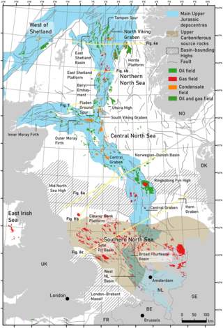
The geology of the North Sea describes the geological features such as channels, trenches, and ridges today and the geological history, plate tectonics, and geological events that created them.

The Olympic-Wallowa lineament (OWL) – first reported by cartographer Erwin Raisz in 1945 on a relief map of the continental United States – is a physiographic feature of unknown origin in the state of Washington running approximately from the town of Port Angeles, on the Olympic Peninsula to the Wallowa Mountains of eastern Oregon.

The Iberian Plate with the microcontinent Iberia encompassed not only the Iberian Peninsula but also Corsica, Sardinia, the Balearic Islands, and the Briançonnais zone of the Penninic nappes of the Alps. The Iberian plate is a part of the Eurasian plate.
Plate reconstruction is the process of reconstructing the positions of tectonic plates relative to each other or to other reference frames, such as the earth's magnetic field or groups of hotspots, in the geological past. This helps determine the shape and make-up of ancient supercontinents and provides a basis for paleogeographic reconstructions.

Pelso Plate or Pelsonia Terrane is a small tectonic unit. It is situated in the Pannonian Basin in Europe. The Carpathian Mountains and the basin surrounded by them were formed from the Cretaceous until the Miocene in the collision of continental Europe with smaller continental fragments of ALCAPA, Tisza, Pelso and Dacia microplates. The Zagreb-Hernád line is the former plate margin between the Pelso of African origin and the Tisza Plate of Eurasian origin.

The Tuareg Shield is a geological formation lying between the West African craton and the Saharan Metacraton in West Africa. Named after the Tuareg people, it has complex a geology, reflecting the collision between these cratons and later events. The landmass covers parts of Algeria, Niger and Mali.
The evolution of tectonophysics is closely linked to the history of the continental drift and plate tectonics hypotheses. The continental drift/ Airy-Heiskanen isostasy hypothesis had many flaws and scarce data. The fixist/ Pratt-Hayford isostasy, the contracting Earth and the expanding Earth concepts had many flaws as well.

Siletzia is a massive formation of early to middle Eocene epoch marine basalts and interbedded sediments in the forearc of the Cascadia subduction zone, on the west coast of North America. It forms the basement rock under western Oregon and Washington and the southern tip of Vancouver Island. It is now fragmented into the Siletz and Crescent terranes.
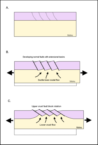
Tilted block faulting, also called rotational block faulting, is a mode of structural evolution in extensional tectonic events, a result of tectonic plates stretching apart. When the upper lithospheric crust experiences extensional pressures, the brittle crust fractures, creating detachment faults. These normal faults express themselves on a regional scale; upper crust fractures into tilted fault blocks, and ductile lower crust ascends. This results in uplift, cooling, and exhumation of ductilely deformed deeper crust. The large unit of tilted blocks and associated crust can form an integral part of metamorphic core complexes, which are found on both continental and oceanic crust.
The South China Sea Basin is one of the largest marginal basins in Asia. South China Sea is located to the east of Vietnam, west of Philippines and the Luzon Strait, and north of Borneo. Tectonically, it is surrounded by the Indochina Block on the west, Philippine Sea Plate on the east, Yangtze Block to the north. A subduction boundary exists between the Philippine Sea Plate and the Asian Plate. The formation of the South China Sea Basin was closely related with the collision between the Indian Plate and Eurasian Plates. The collision thickened the continental crust and changed the elevation of the topography from the Himalayan orogenic zone to the South China Sea, especially around the Tibetan Plateau. The location of the South China Sea makes it a product of several tectonic events. All the plates around the South China Sea Basin underwent clockwise rotation, subduction and experienced an extrusion process from the early Cenozoic to the Late Miocene.
Marjorie Wilson is an English geologist and petrologist known for her formative work on the origin of igneous rocks. Her most significant book is Igneous Petrogenesis: A Global Tectonic Approach, published in 1989. The book was reprinted in 2007.

The geology of Germany is heavily influenced by several phases of orogeny in the Paleozoic and the Cenozoic, by sedimentation in shelf seas and epicontinental seas and on plains in the Permian and Mesozoic as well as by the Quaternary glaciations.
The Eurekan orogeny was a Phanerozoic mountain building event that affected the eastern portion of the Arctic Archipelago and, to a lesser extent, northern Greenland. Deformation initiated in the Late Cretaceous, during which time the Sverdrup Basin began to fragment and fold in response to the counterclockwise rotation of Greenland, caused by seafloor spreading in the Canadian Arctic Rift System. Isostatic uplift was most pronounced in the Grantland Mountains and Victoria and Albert Mountains on Ellesmere Island and in the Princess Margaret Range on Axel Heiberg Island, as evidenced by the current physiography. Compression in a broad zone on Ellesmere Island resulted in the formation of the Eurekan Fold Belt.


