Baltica is a paleocontinent that formed in the Paleoproterozoic and now constitutes northwestern Eurasia, or Europe north of the Trans-European Suture Zone and west of the Ural Mountains. The thick core of Baltica, the East European Craton, is more than three billion years old and formed part of the Rodinia supercontinent at c. 1 Ga.

The Caledonian orogeny was a mountain-building cycle recorded in the northern parts of the British Isles, the Scandinavian Caledonides, Svalbard, eastern Greenland and parts of north-central Europe. The Caledonian orogeny encompasses events that occurred from the Ordovician to Early Devonian, roughly 490–390 million years ago (Ma). It was caused by the closure of the Iapetus Ocean when the Laurentia and Baltica continents and the Avalonia microcontinent collided.

The geology of Australia includes virtually all known rock types, spanning a geological time period of over 3.8 billion years, including some of the oldest rocks on earth. Australia is a continent situated on the Indo-Australian Plate.
In geology, tectonostratigraphy is stratigraphy that refers either to rock sequences in which large-scale layering is caused by the stacking of thrust sheets, or nappes, in areas of thrust tectonics or to the effects of tectonics on lithostratigraphy.
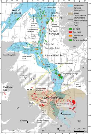
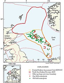
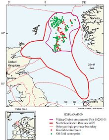
The geology of the North Sea describes the geological features such as channels, trenches, and ridges today and the geological history, plate tectonics, and geological events that created them.
The Massif Central is one of the two large basement massifs in France, the other being the Armorican Massif. The Massif Central's geological evolution started in the late Neoproterozoic and continues to this day. It has been shaped mainly by the Caledonian orogeny and the Variscan orogeny. The Alpine orogeny has also left its imprints, probably causing the important Cenozoic volcanism. The Massif Central has a very long geological history, underlined by zircon ages dating back into the Archaean 3 billion years ago. Structurally it consists mainly of stacked metamorphic basement nappes.

The Pyrenees are a 430-kilometre-long, roughly east–west striking, intracontinental mountain chain that divide France, Spain, and Andorra. The belt has an extended, polycyclic geological evolution dating back to the Precambrian. The chain's present configuration is due to the collision between the microcontinent Iberia and the southwestern promontory of the European Plate. The two continents were approaching each other since the onset of the Upper Cretaceous (Albian/Cenomanian) about 100 million years ago and were consequently colliding during the Paleogene (Eocene/Oligocene) 55 to 25 million years ago. After its uplift, the chain experienced intense erosion and isostatic readjustments. A cross-section through the chain shows an asymmetric flower-like structure with steeper dips on the French side. The Pyrenees are not solely the result of compressional forces, but also show an important sinistral shearing.

The geology of Russia, the world's largest country, which extends over much of northern Eurasia, consists of several stable cratons and sedimentary platforms bounded by orogenic (mountain) belts.

The geology of North America is a subject of regional geology and covers the North American continent, the third-largest in the world. Geologic units and processes are investigated on a large scale to reach a synthesized picture of the geological development of the continent.

The Nordfjord—Sogn Detachment (NSD) is a major extensional shear zone in Norway up to 6 km in thickness, which extends about 120 km along strike from Nordfjord to Sognefjord, bringing Devonian continental coarse clastic sedimentary rocks into close contact with eclogite facies metamorphic rocks of the Western Gneiss Region. It formed towards the end of the Caledonian Orogeny and was mainly active during the Devonian. It has an estimated displacement of at least 70 km and possibly as much as 110

The geology of Svalbard encompasses the geological description of rock types found in Svalbard, and the associated tectonics and sedimentological history of soils and rocks. The geological exploration of Svalbard is an ongoing activity, and recent understandings may differ from earlier interpretations.
The geology of Mauritania is built on more than two billion year old Archean crystalline basement rock in the Reguibat Shield of the West African Craton, a section of ancient and stable continental crust. Mobile belts and the large Taoudeni Basin formed and filled with sediments in the connection with the Pan-African orogeny mountain building event 600 million years ago and a subsequent orogeny created the Mauritanide Belt. In the last 251 million years, Mauritania has accumulated additional sedimentary rocks during periods of marine transgression and sea level retreat. The arid country is 50% covered in sand dunes and has extensive mineral resources, although iron plays the most important role in the economy.

The geology of Sweden is the regional study of rocks, minerals, tectonics, natural resources and groundwater in the country. The oldest rocks in Sweden date to more than 2.5 billion years ago in the Precambrian. Complex orogeny mountain building events and other tectonic occurrences built up extensive metamorphic crystalline basement rock that often contains valuable metal deposits throughout much of the country. Metamorphism continued into the Paleozoic after the Snowball Earth glaciation as the continent Baltica collided with an island arc and then the continent Laurentia. Sedimentary rocks are most common in southern Sweden with thick sequences from the last 250 million years underlying Malmö and older marine sedimentary rocks forming the surface of Gotland.
The geology of Belgium encompasses rocks, minerals and tectonic events stretching back more than 500 million years. Belgium covers an area of about 30,507 square kilometers and was instrumental in the development of geology. The extensive outcrops in Belgium became the standard reference points in stratigraphy as early as the mid-19th century. Some of them are internationally recognized features related to the Carboniferous and the Devonian periods. These rocks were folded by two mountain building events: the Hercynian orogeny and Caledonian Orogeny. Paleozoic basement rocks cover much of the country and are overlain by Mesozoic and Cenozoic sediments.

The geology of Nevada began to form in the Proterozoic at the western margin of North America. Terranes accreted to the continent as a marine environment dominated the area through the Paleozoic and Mesozoic periods. Intense volcanism, the horst and graben landscape of the Basin and Range Province originating from the Farallon Plate, and both glaciers and valley lakes have played important roles in the region throughout the past 66 million years.

The geology of the State of New York is made up of ancient Precambrian crystalline basement rock, forming the Adirondack Mountains and the bedrock of much of the state. These rocks experienced numerous deformations during mountain building events and much of the region was flooded by shallow seas depositing thick sequences of sedimentary rock during the Paleozoic. Fewer rocks have deposited since the Mesozoic as several kilometers of rock have eroded into the continental shelf and Atlantic coastal plain, although volcanic and sedimentary rocks in the Newark Basin are a prominent fossil-bearing feature near New York City from the Mesozoic rifting of the supercontinent Pangea.

The geology of North Carolina includes ancient Proterozoic rocks belonging to the Grenville Province in the Blue Ridge. The region experienced igneous activity and the addition of new terranes and orogeny mountain building events throughout the Paleozoic, followed by the rifting of the Atlantic Ocean and the deposition of thick sediments in the Coastal Plain and offshore waters.
The geology of the Norwegian Sea began to form 60 million years ago in the early Cenozoic, as rifting led to the eruption of mafic oceanic crust, separating Scandinavia and Greenland. Together with the North Sea the Norwegian Sea has become highly researched since the 1960s with the discovery of oil and natural gas in thick offshore sediments on top of the Norwegian continental shelf.

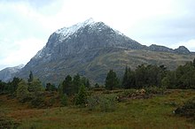
The Hornelen Basin is a sedimentary basin in Vestland, Norway, containing an estimated 25 km stratigraphic thickness of coarse clastic sedimentary rocks of Devonian age. It forms part of a group of basins of similar age along the west coast of Norway between Sognefjord and Nordfjord, related to movement on the Nordfjord-Sogn Detachment. It formed as a result of extensional tectonics as part of the post-orogenic collapse of crust that was thickened during the Caledonian Orogeny towards the end of the Silurian period. It is named for the mountain Hornelen on the northern margin of the basin.

The Solund Basin is a sedimentary basin containing at least 6 km of mainly coarse conglomerates of Devonian age. It is the southernmost of a group of basins of similar age found along the southwest coast of Norway between Sognefjord and Nordfjord, developed in the hanging-wall of the Nordfjord-Sogn Detachment. It was formed as a result of extensional tectonics during the post-orogenic collapse of crust thickened during the Caledonian orogeny, towards the end of the Silurian period. It is named for the municipality of Solund in Vestland.