Geology of Sweden

Last updated
Geological map of Fennoscandia.
.mw-parser-output .legend{page-break-inside:avoid;break-inside:avoid-column}.mw-parser-output .legend-color{display:inline-block;min-width:1.25em;height:1.25em;line-height:1.25;margin:1px 0;text-align:center;border:1px solid black;background-color:transparent;color:black}.mw-parser-output .legend-text{}
Archean rocks of the Karelia, Belomorian and Kola domains
Proterozoic rocks of the Karelia and Kola domains
Svecofennian Domain
Transscandinavian Igneous Belt
Timanide Orogen
Sveconorwegian Orogen inc. the Western Gneiss Region
Caledonian nappes Overview Baltic shield.png
Geological map of Fennoscandia.
   Archean rocks of the Karelia, Belomorian and Kola domains
   Proterozoic rocks of the Karelia and Kola domains
  Sveconorwegian Orogen inc. the Western Gneiss Region

The geology of Sweden is the regional study of rocks, minerals, tectonics, natural resources and groundwater in the country. The oldest rocks in Sweden date to more than 2.5 billion years ago in the Precambrian. Complex orogeny mountain building events and other tectonic occurrences built up extensive metamorphic crystalline basement rock that often contains valuable metal deposits throughout much of the country. Metamorphism continued into the Paleozoic after the Snowball Earth glaciation as the continent Baltica collided with an island arc and then the continent Laurentia. Sedimentary rocks are most common in southern Sweden with thick sequences from the last 250 million years underlying Malmö and older marine sedimentary rocks forming the surface of Gotland. [1]

Contents

Stratigraphy, Tectonics & Geologic History

The oldest rocks in Sweden date to the Archean, more than 2.5 billion years ago. Archean crystalline basement rocks are restricted to a few areas in the far north and are mainly orthogneiss and paragneiss migmatite. Relatively few age studies had been conducted on the rocks by the late 1990s, although they are interpreted as being more than 2.7 billion years old. Studies on younger Paleoproterozoic intrusions in the Skellefte district suggest that the intrusions derived from the Archean parent rock along a line stretching 100 kilometers northeast from the area. However, in south-central and southeast Sweden, the younger rock does not appear to derive from the Archean rocks.

Northern Sweden has greenstone belts made up of mafic volcanic rocks with intercalations of komatiite, quartzite, graphite schist and Lapponian marble. Uranium-lead dating in the lower part of the Kiruna greenstone belt indicates mafic volcanism started in the Archean around 2.7 billion years ago and ended before the intrusion of mafic dikes 2.2 billion years ago. Quartzite, feldspathic meta-sandstone, mica schist and Jatulian dolomite are the other dominant metasupracrustal rocks in the area.

The Svecokarelian Orogeny between 1.95 and 1.85 billion years ago deposited the metavolcanic and metasedimentary Svecofennian-Kalevian rocks, along with calc-alkaline granitoid intrusions. Felsic metavolcanic rocks from 1.9-1.88 billion years ago are the uppermost sequence in the Kiruna area. The region also has some meta-greywacke and mica schist. [2]

Dating of rocks in the Finnish part of the Fennoscandian Shield suggests that the rocks there are somewhat older, forming starting two billion years ago. There are two felsic volcanic complexes in the Skellefte district south of the greenstone belts, spanning into the Arvidsjaur district. These rocks deposited below water and were later affected by low-grade metamorphism. South of the Skellefte district in north-central Sweden, in the Bothnian Basin, metagrayacke interlayers with metavolcanic rocks and metamorphosed under high pressure to paragneiss and migmatite.

Proterozoic (2.5 billion-539 million years ago)

Granite, in Smogen (southwestern Sweden), formed during the Sveconorwegian orogeny Bohuslen geology IMG 0139 Smogen - Kleven.jpg
Granite, in Smögen (southwestern Sweden), formed during the Sveconorwegian orogeny

The Paleoproterozoic rocks emplaced by the Svecokarelian orogeny were intruded by granite and mafic dikes, overlain with clastic sedimentary rocks and in some places, basalt. The granites range between 1.58 and 1.4 million years ago and some are rapakivi granite associated with syenite, gabbro and anorthosite. Swarms of mafic dikes are dated to 1.56-1.5, 1.25-1.2 and one billion to 900 million years ago, striking north-northwest in the western part of the Svecokarelian orogen.

The Sveconorwegian Orogeny is 500 kilometers long and 180 kilometers wide. West of its frontal deformation zone, geologists divide the orogen into Eastern, Median and Western segments, separated by ductile deformation zones, striking north-south. These ductile zones are identified as the Mylonite Zone, between the Eastern and Median segments and the Gota Alv Zone-Dalskand Boundary Thrust. Along the southwest coast of Sweden, the Mylonite Zone separates high-pressure granulite and charnockite from medium-grade metamorphic rocks in the Median zone. For the most part, the rocks in the orogen were affected first by the Gothian tectonic event, 1.65-1.56 billion years ago, and then by the Sveconorwegian Orogeny from 1.1 to 900 million years ago.

TIB granitoids dominate the eastern segment north of Lake Vattern. In the western segment, metavolcanic rocks and metagraywacke from 1.76 billion years ago is most common. The Amal-Horred belt contains younger intermediate metavolcanic rocks, intruded by calc-alkaline granitoids.

Granite, syenite and mafic intrusions are distributed throughout the broader grouping of Sveconorwegian rocks, which intruded before the Gothian event, but before extensive deformation took place. Aside from a skarn iron oxide and manganese deposit at Langban and some copper, lead and zinc mineralization, the Sveconorwegian rocks tend to be poor in metal resources. However, kyanite quartzite, slate, kaolin and pure quartz are sometimes mined along with granite. [3]

In the Neoproterozoic, the Visingso Group rocks, including sandstone, conglomerate, siltstone and shale deposited.

Paleozoic (539-251 million years ago)

In six areas in south-central Sweden, early Paleozoic rocks lie unconformably atop the Fennoscandian Shield, made up of 200 meter thick Cambrian shallow marine quartz arenite, as well as black shales from the Ordovician, and Silurian limestone, sandstone and shale. Early Cambrian sandstone is preserved in some places in fractures in the Precambrian bedrock. The bedrock of Gotland is almost exclusively Silurian limestone and shale.

Tjakkeli, a mountain in Norrbotten County (northern Sweden), is made of mylonitised syenitoid-granitic igneous rock above quartz arenite sedimentary rock (about 1,880 to 490 million years old), originally formed in another location and transported eastward during the Caledonian orogeny, about 450 million years ago, as part of a large nappe fold, thrust on top of the underlying Svecokarelian basement (about 1,920 to 1,870 million years old) Tjakkeli.jpg
Tjakkeli, a mountain in Norrbotten County (northern Sweden), is made of mylonitised syenitoid-granitic igneous rock above quartz arenite sedimentary rock (about 1,880 to 490 million years old), originally formed in another location and transported eastward during the Caledonian orogeny, about 450 million years ago, as part of a large nappe fold, thrust on top of the underlying Svecokarelian basement (about 1,920 to 1,870 million years old)

The Swedish Caledonides formed due to an orogeny in the early Paleozoic, along the western margin of Sweden approximately 510 to 400 million years ago. The Caledonides are 900 kilometers long and 120 kilometers wide and is dominated by a series of thrust sheets, on top of Precambrian allochthon formations. Tectonic shortening at the margin of the ancient continent Baltica produced the Lower Allochthon, Middle Allochthon and Upper Allochthon as well as the Seve Nappes. Prior to tectonic shortening, the margin of the continent extended 400 kilometers further west.

The Lower Allochthon is made up of foreland fold-and-thrust belt rocks and contains slabs of Precambrian crystalline rock and clastic sedimentary and limestone cover rocks. The Middle Allochthon is similar, but contains Neoproterozoic metasedimentary rocks, many of which show glacial origins. The Sarv Nappe—the highest thrust sheet—contains dolerite from 600 million years ago. The overlying Seve Nappe formed along a continent-ocean transition, with mafic and ultramafic meta-igneous rocks. These rocks were buried to a depth of 60 kilometers. As the Caledonides built up, deformation increased, forming eclogite in the middle Ordovician.

The complex tectonic evolution of the Caledonides built up lead-zinc sulfides from the Neoproterozoic to the Cambrian in quartz arenite, along with subsequent, more widely distributed zinc, copper, gold and lead deposits. The Lower and Middle Allochthon contain valuable quantities of metasandstone and limestone.

The Caledonides formed during the breakup of a supercontinent in the Neoproterozoic as Baltica became an independent continent after the Snowball Earth glaciation. The orogeny occurred as the Iapetus Ocean closed, with the collision between Baltica and an island arc. During the Silurian, Balitca was situated on the equator and the subduction of oceanic crust had closed the gap with Laurentia (proto-North America), beginning the formation of the new supercontinent Pangaea. [7]

Mesozoic-Cenozoic (251 million years ago-present)

The Tornquist Zone in southern Sweden is a zone of faults, bounding Fennoscandian Shield, have been active since the Carboniferous. Early Paleozoic rocks in this area are up to one kilometer thick, continuing upward into Mesozoic and Cenozoic shale, siltstone and sandstone. The Late Cretaceous and early Cenozoic is marked by limestone two to three kilometers thick, in and around Malmö. [8]

Mineral resources

Iron ore (hematite and magnetite) from Gallivare Haematit-malmberget-gaellivare hg.jpg
Iron ore (hematite and magnetite) from Gällivare
Map of natural resources - metals are in blue (Fe, Cu, Zn, As (semi-metal), Ag, W, Au, Pb, U; PY -- pyrite), fossil fuels are in red (C -- coal, OS -- oil shale) Natural resources of Sweden.png
Map of natural resources - metals are in blue (Fe, Cu, Zn, As (semi-metal), Ag, W, Au, Pb, U; PY — pyrite), fossil fuels are in red (C — coal, OS — oil shale)

Copper, gold and iron have been mined in Sweden since the Middle Ages. For instance, the Falun copper mine in the Bergslagen district had been mined for over 700 years at the time of its closure in the 1990s. Historically, the Bergslagen area has had the most extensive mining—with over 3000 ore workings in the 18th and 19th centuries. Since the beginning of the 20th century, the discovery of metasupracrustral and greenstone belt rocks in northern Sweden has opened up new resources, such as the Kiruna iron ore, Viscaria copper deposit and the Aitik gold and silver deposit. The Skellefte district is known for a massive sulfide deposit hosted in metavolcanic rocks, together with gold mineralization in quartz veins. The Swedish Caledonides also host massive sulfide deposits. In 1997, only 17 metal mines were active, even though 400 significant metal deposits were known throughout the country.

Non-metallic resources include Paleozoic limestone extracted on Gotland in the 1100s through the 1500s for use in city walls and house throughout the Hanseatic League. In the early 20th century, mines extracted black shale in south-central Sweden for energy. [9]

Related Research Articles

<span class="mw-page-title-main">Geology of Norway</span>

The geology of Norway encompasses the history of Earth that can be interpreted by rock types found in Norway, and the associated sedimentological history of soils and rock types.

<span class="mw-page-title-main">Laurentia</span> A large continental craton that forms the ancient geological core of the North American continent

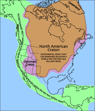
Laurentia or the North American Craton is a large continental craton that forms the ancient geological core of North America. Many times in its past, Laurentia has been a separate continent, as it is now in the form of North America, although originally it also included the cratonic areas of Greenland and also the northwestern part of Scotland, known as the Hebridean Terrane. During other times in its past, Laurentia has been part of larger continents and supercontinents and itself consists of many smaller terranes assembled on a network of Early Proterozoic orogenic belts. Small microcontinents and oceanic islands collided with and sutured onto the ever-growing Laurentia, and together formed the stable Precambrian craton seen today.

<span class="mw-page-title-main">Geology of Finland</span> Overview of the geology of Finland

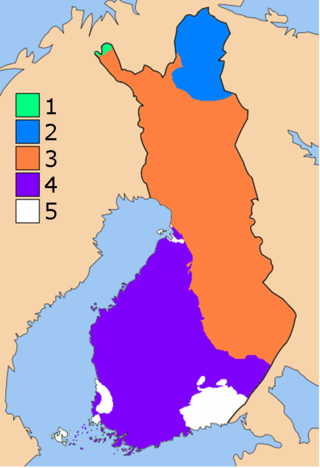
The geology of Finland is made up of a mix of geologically very young and very old materials. Common rock types are orthogneiss, granite, metavolcanics and metasedimentary rocks. On top of these lies a widespread thin layer of unconsolidated deposits formed in connection to the Quaternary ice ages, for example eskers, till and marine clay. The topographic relief is rather subdued because mountain massifs were worn down to a peneplain long ago.

<span class="mw-page-title-main">Scandinavian Caledonides</span> Remains of an orogenic belt formed during the Silurian–Devonian period

The Scandinavian Caledonides are the vestiges of an ancient, today deeply eroded orogenic belt formed during the Silurian–Devonian continental collision of Baltica and Laurentia, which is referred to as the Scandian phase of the Caledonian orogeny. The size of the Scandinavian Caledonides at the time of their formation can be compared with the size of the Himalayas. The area east of the Scandinavian Caledonides, including parts of Finland, developed into a foreland basin where old rocks and surfaces were covered by sediments. Today, the Scandinavian Caledonides underlay most of the western and northern Scandinavian Peninsula, whereas other parts of the Caledonides can be traced into West and Central Europe as well as parts of Greenland and eastern North America.

The geology of Liberia is largely extremely ancient rock formed between 3.5 billion and 539 million years ago in the Archean and the Neoproterozoic, with some rocks from the past 145 million years near the coast. The country has rich iron resources as well as some diamonds, gold and other minerals in ancient sediment formations weathered to higher concentrations by tropical rainfall.

<span class="mw-page-title-main">Geology of Ghana</span>

The geology of Ghana is primarily very ancient crystalline basement rock, volcanic belts and sedimentary basins, affected by periods of igneous activity and two major orogeny mountain building events. Aside from modern sediments and some rocks formed within the past 541 million years of the Phanerozoic Eon, along the coast, many of the rocks in Ghana formed close to one billion years ago or older leading to five different types of gold deposit formation, which gave the region its former name Gold Coast.

The geology of Mauritania is built on more than two billion year old Archean crystalline basement rock in the Reguibat Shield of the West African Craton, a section of ancient and stable continental crust. Mobile belts and the large Taoudeni Basin formed and filled with sediments in the connection with the Pan-African orogeny mountain building event 600 million years ago and a subsequent orogeny created the Mauritanide Belt. In the last 251 million years, Mauritania has accumulated additional sedimentary rocks during periods of marine transgression and sea level retreat. The arid country is 50% covered in sand dunes and has extensive mineral resources, although iron plays the most important role in the economy.

The geology of Niger comprises very ancient igneous and metamorphic crystalline basement rocks in the west, more than 2.2 billion years old formed in the late Archean and Proterozoic eons of the Precambrian. The Volta Basin, Air Massif and the Iullemeden Basin began to form in the Neoproterozoic and Paleozoic, along with numerous ring complexes, as the region experienced events such as glaciation and the Pan-African orogeny. Today, Niger has extensive mineral resources due to complex mineralization and laterite weathering including uranium, molybdenum, iron, coal, silver, nickel, cobalt and other resources.

The geology of Nigeria formed beginning in the Archean and Proterozoic eons of the Precambrian. The country forms the Nigerian Province and more than half of its surface is igneous and metamorphic crystalline basement rock from the Precambrian. Between 2.9 billion and 500 million years ago, Nigeria was affected by three major orogeny mountain-building events and related igneous intrusions. Following the Pan-African orogeny, in the Cambrian at the time that multi-cellular life proliferated, Nigeria began to experience regional sedimentation and witnessed new igneous intrusions. By the Cretaceous period of the late Mesozoic, massive sedimentation was underway in different basins, due to a large marine transgression. By the Eocene, in the Cenozoic, the region returned to terrestrial conditions.

The geology of Estonia is the study of rocks, minerals, water, landforms and geologic history in Estonia. The crust is part of the East European Craton and formed beginning in the Paleoproterozoic nearly two billion years ago. Shallow marine environments predominated in Estonia, producing extensive natural resources from organic matter such as oil shale and phosphorite. The Mesozoic and much of the Cenozoic are not well-preserved in the rock record, although the glaciations during the Pleistocene buried deep valleys in sediment, rechanneled streams and left a landscape of extensive lakes and peat bogs.

The geology of Georgia is the study of rocks, minerals, water, landforms and geologic history in Georgia. The country is dominated by the Caucasus Mountains at the junction of the Eurasian Plate and the Afro-Arabian Plate, and rock units from the Mesozoic and Cenozoic are particularly prevalent. For much of its geologic history, until the uplift of the Caucasus, Georgia was submerged by marine transgression events. Geologic research for 150 years by Georgian and Russian geologists has shed significant light on the region and since the 1970s has been augmented with the understanding of plate tectonics.

<span class="mw-page-title-main">Geology of Bosnia and Herzegovina</span>

The geology of Bosnia & Herzegovina is the study of rocks, minerals, water, landforms and geologic history in the country. The oldest rocks exposed at or near the surface date to the Paleozoic and the Precambrian geologic history of the region remains poorly understood. Complex assemblages of flysch, ophiolite, mélange and igneous plutons together with thick sedimentary units are a defining characteristic of the Dinaric Alps, also known as the Dinaride Mountains, which dominate much of the country's landscape.

The geology of Ukraine is the regional study of rocks, minerals, tectonics, natural resources and groundwater in the country. The oldest rocks in the region are part of the Ukrainian Shield and formed more than 2.5 billion years ago in the Archean eon of the Precambrian. Extensive tectonic evolution and numerous orogeny mountain building events fractured the crust into numerous block, horsts, grabens and depressions and Ukraine was intermittently flooded as the crust downwarped during much of the Paleozoic, Mesozoic and early Cenozoic, before the formation of the Alps and Carpathians defined much of its current topography and tectonics. Ukraine was impacted by the Pleistocene glaciations within the last several hundred thousand years. The country has numerous metal deposits as well as minerals, building stone and high-quality industrial sands.

<span class="mw-page-title-main">Geology of Kazakhstan</span>

The geology of Kazakhstan includes extensive basement rocks from the Precambrian and widespread Paleozoic rocks, as well as sediments formed in rift basins during the Mesozoic.

<span class="mw-page-title-main">Geology of Uzbekistan</span>

The geology of Uzbekistan consists of two microcontinents and the remnants of oceanic crust, which fused together into a tectonically complex but resource rich land mass during the Paleozoic, before becoming draped in thick, primarily marine sedimentary units.

<span class="mw-page-title-main">Geology of North Korea</span>

The geology of North Korea has been studied by the Central Geological Survey of Mineral Resources, rare international research and by inference from South Korea's geology.

<span class="mw-page-title-main">Geology of Bulgaria</span>

The geology of Bulgaria consists of two major structural features. The Rhodope Massif in southern Bulgaria is made up of Archean, Proterozoic and Cambrian rocks and is a sub-province of the Thracian-Anatolian polymetallic province. It has dropped down, faulted basins filled with Cenozoic sediments and volcanic rocks. The Moesian Platform to the north extends into Romania and has Paleozoic rocks covered by rocks from the Mesozoic, typically buried by thick Danube River valley Quaternary sediments. In places, the Moesian Platform has small oil and gas fields. Bulgaria is a country in southeastern Europe. It is bordered by Romania to the north, Serbia and North Macedonia to the west, Greece and Turkey to the south, and the Black Sea to the east.

<span class="mw-page-title-main">Geology of Latvia</span>

Geology of Latvia includes an ancient Archean and Proterozoic crystalline basement overlain with Neoproterozoic volcanic rocks and numerous sedimentary rock sequences from the Paleozoic, some from the Mesozoic and many from the recent Quaternary past. Latvia is a country in the Baltic region of Northern Europe.

The geology of Newfoundland and Labrador includes basement rocks formed as part of the Grenville Province in the west and Labrador and the Avalonian microcontinent in the east. Extensive tectonic changes, metamorphism and volcanic activity have formed the region throughout Earth history.

The geology of Yukon includes sections of ancient Precambrian Proterozoic rock from the western edge of the proto-North American continent Laurentia, with several different island arc terranes added through the Paleozoic, Mesozoic and Cenozoic, driving volcanism, pluton formation and sedimentation.

References

  1. Moores & Fairbridge 1997, pp. 690–703.
  2. Moores & Fairbridge 1997, p. 695.
  3. Moores & Fairbridge 1997, p. 697-698.
  4. "Berggrund 1:50 000-1:250 000" [ Bedrock 1:50,000-1:250,000] (in Swedish). SGU (Geological Survey of Sweden). Retrieved 25 September 2020.
  5. Hoppe, G.; Melander, O. (1979). Geomorphological map 28 I Stora Sjöfallet - Description and assessment of areas of geomorphological importance (PDF). Stockholm: Stockholms universitet Naturgeografiska institutionen.
  6. Johansson, A. (26 May 2020). "Fjällkedjans bildning och uppbyggnad" [The formation and structure of the mountain range]. Sveriges geologi (in Swedish). Naturhistoriska riksmuseet . Retrieved 25 September 2020.
  7. Moores & Fairbridge 1997, p. 701-702.
  8. Moores & Fairbridge 1997, p. 699.
  9. Moores & Fairbridge 1997, p. 691.

Bibliography