
Armenia is a landlocked country in the South Caucasus region of the Caucasus. The country is geographically located in West Asia, within the Armenian plateau. Armenia is bordered on the north and east by Georgia and Azerbaijan and on the south and west by Iran, Azerbaijan's exclave Nakhchivan, and Turkey.

The Anatolian side of Turkey is the largest portion in the country that bridges southeastern Europe and west Asia. East Thrace, the European portion of Turkey comprises 3% of the landmass but over 15% of the population. East Thrace is separated from Asia Minor, the Asian portion of Turkey, by the Bosporus, the Sea of Marmara and the Dardanelles. İskilip, Çorum province, is considered to be the geographical center of Earth. Turkey is very vulnerable to earthquakes.

The Caucasus Mountains is a mountain range at the intersection of Asia and Europe. Stretching between the Black Sea and the Caspian Sea, they are surrounded by the Caucasus region and are home to Mount Elbrus, the highest peak in Europe at 5,642 metres (18,510 ft) above sea level.

The Iranian Plateau or Persian Plateau is a geological feature spanning parts of Central Asia, South Asia, and West Asia. It makes up part of the Eurasian Plate, and is wedged between the Arabian Plate and the Indian Plate. The plateau is situated between the Zagros Mountains to the west, the Caspian Sea and the Köpet Dag to the north, the Armenian Highlands and the Caucasus Mountains to the northwest, the Strait of Hormuz and the Persian Gulf to the south, and the Indian subcontinent to the east.

The Aras is a river in the Caucasus. It rises in eastern Turkey and flows along the borders between Turkey and Armenia, between Turkey and the Nakhchivan exclave of Azerbaijan, between Iran and both Azerbaijan and Armenia, and, finally, through Azerbaijan where it flows into the Kura river. It drains the south side of the Lesser Caucasus Mountains while the Kura drains the north side of the Lesser Caucasus. The river's total length is 1,072 km (666 mi) and its watershed covers an area of 102,000 km2 (39,000 sq mi). The Aras is one of the longest rivers in the Caucasus.

Gegharkunik is a province (marz) of Armenia. Its capital and largest city is Gavar.

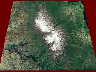
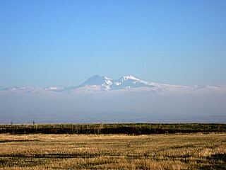
Mount Aragats is an isolated four-peaked volcano massif in Armenia. Its northern summit, at 4,090 m (13,420 ft) above sea level, is the highest point of the Lesser Caucasus and Armenia. It is also one of the highest points in the Armenian Highlands.

The Hrazdan is a major river and the second largest in Armenia. It originates at the northwest extremity of Lake Sevan and flows south through the Kotayk Province and Armenia's capital, Yerevan; the lake in turn is fed by several streams. In the Ararat plain it joins the Aras river along the border with Turkey. Its waters join the Kura river, before flowing into the Caspian Sea.

The Lesser Caucasus or Lesser Caucasus Mountains, also called Caucasus Minor, is the second of the two main ranges of the Caucasus Mountains, of length about 600 km (370 mi). The western portion of the Lesser Caucasus overlaps and converges with east Turkey and northwest Iran. It runs parallel to the Greater Caucasus, at a distance averaging about 100 km (62 mi) south from the Likhi Range (Georgia) and limits east Turkey from the north and north-east. It is connected to the Greater Caucasus by the Likhi Range (Georgia) and separated from it by the Kolkhida Lowland (Georgia) in the west and Kura-Aras Lowland (Azerbaijan) in the east.

The Armenian highlands is the most central and the highest of the three plateaus that together form the northern sector of West Asia. Clockwise starting from the west, the Armenian highlands are bounded by the Anatolian plateau, the Caucasus, the Kura-Aras lowlands, the Iranian Plateau, and Mesopotamia. The highlands are divided into western and eastern regions, defined by the Ararat Valley where Mount Ararat is located. Western Armenia is nowadays referred to as eastern Anatolia, and Eastern Armenia as the Lesser Caucasus or Caucasus Minor, and historically as the Anti-Caucasus, meaning "opposite the Caucasus".

Orography of Azerbaijan refers to the rocky, mountainous and elevated terrains in Azerbaijan. The tectonic structure is typical for the orography of the country. The main morphostructural units are the Greater Caucasus, the Lesser Caucasus, the Gusar plane, the Samur-Devechi lowland, the Kur intermountain trough, the Karabagh volcanic highland, the near and middle Araz Ridges and Talysh Mountains.

Armenia a land of rugged mountains and extinct volcanoes, its highest point is Mount Aragats, 13,435 ft.

The Eastern Anatolia Region is a geographical region of Turkey. The most populous province in the region is Van Province. Other populous provinces are Malatya, Erzurum and Elazığ.
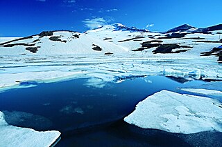
Lake Kari is a freshwater lake in Armenia located on the slopes of Mount Aragats. It is located 3,185 m above sea level and has a perimeter of 1,150 m. Its depth is up to 8 m, its volume is 375,000 m2, and it has a surface area of 0.12 km2. It formed in a u-shaped valley enclosed by moraines. The water of the lake is limpid and cold and comes mainly from precipitation. It is frozen for 8–9 months a year.
Gegham mountains are a range of mountains in Armenia. The range is a tableland-type watershed basin of Sevan Lake from east, inflows of rivers Araks and Hrazdan from north and west, Azat and Vedi rivers from south-west and Arpachai river from south. The average elevation of the Gegham mountain range is near 2500m. The range is of volcanic origin including many extinct volcanoes. The range is 70 km length and 48 km width, and stretch between Lake Sevan and the Ararat plain. The highest peak of the Gegham mountains is the Azhdahak, at 3597m. They are formed by a volcanic field, containing Pleistocene-to-Holocene lava domes and cinder cones. The highland reaches a height of 1800–2000m up to 3000m in the dividing ridge.

The Eastern Anatolian montane steppe is a temperate grasslands, savannas, and shrublands ecoregion. It is located in the Armenian Highlands, covering parts of eastern Turkey, Armenia, Azerbaijan, southern Georgia, and northwestern Iran.
South Caucasus Railway is the sole railway company in Armenia, owned by Russian Railways, responsible for all inter-city, commuter, and freight rail transport in Armenia. The network consists of 780 kilometers of track with all lines in the Russian gauge.

Prielbrusye National Park is in the area around Mount Elbrus, the highest mountain in Europe at 5,642 meters above sea level. The relative isolation of steep gorges has led to high levels of endemism and biodiversity. The park is in the central Caucasus Mountains, one of 22 national parks in the Caucasus of different nationalities, covering 1.8% of the region. The park is situated in Elbrussky District and Zolsky District, in the southwestern corner of the Kabardino-Balkar Republic of Russia.
Shirak Plain, , is a plain located in the Armenian Plateau, at the northwest of Armenia. It roughly occupies almost the entire area of Shirak Province, the southwestern parts of Lori Province, as well as the northern parts of Aragatsotn Province.


