Geology of Kazakhstan

Last updated

The geology of Kazakhstan includes extensive basement rocks from the Precambrian and widespread Paleozoic rocks, as well as sediments formed in rift basins during the Mesozoic. [1]

Contents

Rock outcrop at Bektau Ata PICT1709.JPG
Rock outcrop at Bektau Ata

Geologic history, stratigraphy and tectonics

Archean rocks of the Zerenda Group, including schist, diamond-bearing gneiss, eclogite and marble are found in the Kokchetav Massif in the Kazakh Uplands. However, geologists have disagreed on dating with some indicating dates in the Middle Cambrian or Archean through Paleoproterozoic. Early Proterozoic rocks are better defined and include phyllite, schist, quartzite, porphyroids, porphyritoids, marble and jaspellite, intruded by 1.8 billion year old granite gneiss and 1.7 billion year old granosyenite. The Paleoproterozoic sequence is 14 kilometers thick. In the Jeltau Mountains, the basement is made up gneiss, schist, marble, amphibolite and eclogite. Migmatized gneiss, amphibolite and quartzite are found in the Mugodzhar area. Precambrian rocks are not found in the Kazakh Altai mountains, although they are present where the range extends into Russia and China.

Much of Eastern Europe and Central Asia has Riphean rocks from the Proterozoic. Terrigenous volcanic rocks which may have originated from rifting are located in the South Urals, metamorphosed to greenschist grade, with amphibolites in linear folds. Dolomite limestones with stromatalite fossils and quartzites are found in the Kazakh Uplands. Low-grade metamorphism and granitization took place from 1.2 billion to one billion years ago. All the Precambrian massifs hold Upper Riphean quartzite and quartz sandstone, dated with detritral zircon to 850 million years ago.

Riphean and Vendian deposits occupy the western and southwest parts of the Kazakh Uplands. In Ulutau, alkaline granitoids intruded volcanic rocks 650 million years ago. Lower Vendian rocks are up to 1.5 kilometers thick, including gray clastic rocks, acid tuff and alkali basalt flows. [2]

Paleozoic

Rock outcrop by the Ebita river, Aktobe Region, western Kazakhstan VisitAktobeNemoiAul.jpg
Rock outcrop by the Ebita river, Aktobe Region, western Kazakhstan

Cambrian through Ordovician rocks from the Paleozoic are found in all Kazakhstan's orogenic belts. A thin sequence, 200 to 400 meters thick overlies Vendian rocks in the Kazakh Upland, including coal shale, deepwater chert, limestone, phosphate and barite deposits. The Early Ordovician gives way to 200 meters of shale and chert, followed by flysch up to 3.5 kilometers thick and another thick sequence of andesite, basalt and coarse clastics. Silurian rocks are absent in the uplands.

In Chu-Kungey, Tengiz, Zharma-Saur and other districts, island arc volcanic rocks such as tuff, clastics and reef limestone are up to seven kilometers thick.

In the North Caspian Depression, only Late Paleozoic rocks outcrop at the surface. Deepwater chert and carbonates are common, with deposits up to 25 kilometers thick. Permian up to five kilometers thick has formed domes, which intrude upward into Mesozoic and Paleogene rocks. Carboniferous deepwater limestone forms a four kilometer flysch in the Cis-Urals Foredeep Basin in the South Urals region, which also includes olistrosomes and a Permian salt-bearing marine molasse.

Middle Cambrian rocks in the Kazakh Uplands have an angular unconformity with older rocks because they were thrust onto a magmatic arc in the Devonian to the northwest of the Karaganda Foredeep Basin. Within the foredeep basin, limestone deposition shifted to coal-bearing molasse.

Small synclines in the Karaganda Foredeep Basin show deepwater limestone and shale 450 meters thick from the Carboniferous and Permian, as well as 4.5 kilometer thick coal-bearing molasse. Within the Tengiz Basin, deposits are never more than two kilometers thick and grow thicker to the south. The Chu Basin is filled with undeformed Middle Devonian through Permian red molasse and carbonate deposits. Calc-alkaline magmatism was extensive in the southeast Kazakh Uplands and the Tien Shan Mountains. Geologists have recognized these rocks through magnetic anomalies, drillholes and occasional outcrops. The volcanic rocks include tuff, cooled lava and trachyandesite and rhyolite ignimbrite up to five kilometers thick. [3]

Mesozoic-Cenozoic (251 million years ago-present)

Layers of Paleogene rock in eastern Kazakhstan Palegenovye sloi. Iugo-vostochnyi Kazakhstan. Paleogene layers. Eastern Kazakhstan.JPG
Layers of Paleogene rock in eastern Kazakhstan

Intraplate rifting began in the Triassic, forming massive sedimentary basins between Paleozoic uplands. The North Caspian Depression filled with terrigenous rocks and shallow water carbonates at the edge of the Tethys Ocean, similar to the West Siberian Basin which becomes thicker near the center. The Chu, Turgay, Turan and Kizilkum basins contain sand, clay and coal-bearing shallow water terrigenous sediments and salt deposits two kilometers thick from the Middle Jurassic, up to three kilometers thick from the Cretaceous and one kilometer thick from the Cenozoic.

The Triassic was a period of erosion in the Kazakh Uplands and the Zaysan, Alakol, Balkhash and Tengiz basins are all small and filled with Late Triassic through Jurassic lacustrine deposits. Cretaceous and Paleogene deposits are largely missing, followed by a 100-meter thick sequence of Neogene and Quaternary gypsum-bearing alluvial fan sediments. [4]

Geological research

Geological research in Kazakhstan began in the 18th century due to growing Russian influence along the Ob River, Orenburg to Mugodzar and Petropavlovsk to the Kazakh Steppe. The Russian Academy of Sciences sent some early expeditions, such as Pallas' Asian Expedition in 1771. In the 1800s Russian mining groups explored the Kirgiz Steppe north of the Tien Shan mountains and the construction of the Trans-Siberian Railway prompted further study. The Russian Geological Committee launched regional mapping efforts in 1925, after foreign sources on Central Asian geology disappeared in the aftermath of the Russian Revolution. As recently as the early 1990s, geologists in Kazakhstan were split between plate tectonics and a different set of mobilist theories more similar to the old geosynclinal model. [5]

Natural resource geology

The North Caspian Depression contains oil and natural gas, together with the Chu Basin, where they are associated with salt diapirs, typically in Cretaceous, Paleogene, Jurassic and Triassic sandstone and clay strata. Kazakhstan has rich coal deposits with 300 major deposits and 170.2 billion tons of reserves. Coking coal is primarily extracted from the Karaganda Basin. The Turgay, Balkhash and Maikuben depressions all hold small deposits of Mesozoic coal. The country has about eight billion tons of iron, nickel, cobalt and up to 300 tungsten deposits. Other base metals include aluminum from bauxite in the Turgay Depression and Mugodzhar Mountains, vanadium, titanium-bearing pegmatite or ilmenite-zircon placers, chromium in ophiolites in the South Urals, gold in shale and magmatic arcs, as well as rare earths, lead, zinc, copper and molybdenum.

See also

Related Research Articles

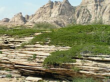
The geology of Morocco formed beginning up to two billion years ago, in the Paleoproterozoic and potentially even earlier. It was affected by the Pan-African orogeny, although the later Hercynian orogeny produced fewer changes and left the Maseta Domain, a large area of remnant Paleozoic massifs. During the Paleozoic, extensive sedimentary deposits preserved marine fossils. Throughout the Mesozoic, the rifting apart of Pangaea to form the Atlantic Ocean created basins and fault blocks, which were blanketed in terrestrial and marine sediments—particularly as a major marine transgression flooded much of the region. In the Cenozoic, a microcontinent covered in sedimentary rocks from the Triassic and Cretaceous collided with northern Morocco, forming the Rif region. Morocco has extensive phosphate and salt reserves, as well as resources such as lead, zinc, copper and silver.

<span class="mw-page-title-main">Geology of Belarus</span>

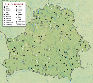
The geology of Belarus began to form more than 2.5 billion years ago in the Precambrian, although many overlying sedimentary units deposited during the Paleozoic and the current Quaternary. Belarus is located in the eastern European plain. From east to west it covers about 650 kilometers while from north to south it covers about 560 kilometers, and the total area is about 207,600 square kilometers. It borders Poland in the north, Lithuania in the northwest, Latvia and Russia in the north, and Ukraine in the south. Belarus has a planar topography with a height of about 160 m above sea level. The highest elevation at 346 meters above sea level is Mt. Dzerzhinskaya, and the lowest point at the height of 80 m is in the Neman River valley.

The geology of Georgia is the study of rocks, minerals, water, landforms and geologic history in Georgia. The country is dominated by the Caucasus Mountains at the junction of the Eurasian Plate and the Afro-Arabian Plate, and rock units from the Mesozoic and Cenozoic are particularly prevalent. For much of its geologic history, until the uplift of the Caucasus, Georgia was submerged by marine transgression events. Geologic research for 150 years by Georgian and Russian geologists has shed significant light on the region and since the 1970s has been augmented with the understanding of plate tectonics.

<span class="mw-page-title-main">Geology of Bosnia and Herzegovina</span>

The geology of Bosnia & Herzegovina is the study of rocks, minerals, water, landforms and geologic history in the country. The oldest rocks exposed at or near the surface date to the Paleozoic and the Precambrian geologic history of the region remains poorly understood. Complex assemblages of flysch, ophiolite, mélange and igneous plutons together with thick sedimentary units are a defining characteristic of the Dinaric Alps, also known as the Dinaride Mountains, which dominate much of the country's landscape.

The geology of Ukraine is the regional study of rocks, minerals, tectonics, natural resources and groundwater in Ukraine. The oldest rocks in the region are part of the Ukrainian Shield and formed more than 2.5 billion years ago in the Archean eon of the Precambrian. Extensive tectonic evolution and numerous orogeny mountain-building events fractured the crust into numerous block, horsts, grabens and depressions. Ukraine was intermittently flooded as the crust downwarped during much of the Paleozoic, Mesozoic and early Cenozoic, before the formation of the Alps and Carpathian Mountains defined much of its current topography and tectonics. Ukraine was impacted by the Pleistocene glaciations within the last several hundred thousand years. The country has numerous metal deposits as well as minerals, building stone and high-quality industrial sands.

<span class="mw-page-title-main">Geology of Moldova</span>

The geology of Moldova encompasses basement rocks from the Precambrian dating back more than 2.5 billion years, overlain by thick sequences of Proterozoic, Paleozoic, Mesozoic and Cenozoic sedimentary rocks.

The geology of Bhutan is less well studied than many countries in Asia, together with the broader Eastern Himalayas region. Older Paleozoic and Precambrian rocks often appear mixed together with younger sediments due to the Himalayan orogeny.

<span class="mw-page-title-main">Geology of North Macedonia</span> Overview of geology in North Macedonia

The geology of North Macedonia includes the study of rocks dating to the Precambrian and a wide array of volcanic, sedimentary and metamorphic rocks formed in the last 539 million years.

<span class="mw-page-title-main">Geology of Afghanistan</span>

The geology of Afghanistan includes nearly one billion year old rocks from the Precambrian. The region experienced widespread marine transgressions and deposition during the Paleozoic and Mesozoic, that continued into the Cenozoic with the uplift of the Hindu Kush mountains.

The geology of Kyrgyzstan began to form during the Proterozoic. The country has experienced long-running uplift events, forming the Tian Shan mountains and large, sediment filled basins.

<span class="mw-page-title-main">Geology of Uzbekistan</span> Geology of Uzbekistan, an west Asian nation

The geology of Uzbekistan consists of two microcontinents and the remnants of oceanic crust, which fused together into a tectonically complex but resource rich land mass during the Paleozoic, before becoming draped in thick, primarily marine sedimentary units.

The geology of Thailand includes deep crystalline metamorphic basement rocks, overlain by extensive sandstone, limestone, turbidites and some volcanic rocks. The region experienced complicated tectonics during the Paleozoic, long-running shallow water conditions and then renewed uplift and erosion in the past several million years ago.

The geology of Turkmenistan includes two different geological provinces: the Karakum, or South Turan Platform, and the Alpine Orogen.

<span class="mw-page-title-main">Geology of North Korea</span>

The geology of North Korea has been studied by the Central Geological Survey of Mineral Resources, rare international research and by inference from South Korea's geology.

<span class="mw-page-title-main">Geology of Bulgaria</span>

The geology of Bulgaria consists of two major structural features. The Rhodope Massif in southern Bulgaria is made up of Archean, Proterozoic and Cambrian rocks and is a sub-province of the Thracian-Anatolian polymetallic province. It has dropped down, faulted basins filled with Cenozoic sediments and volcanic rocks. The Moesian Platform to the north extends into Romania and has Paleozoic rocks covered by rocks from the Mesozoic, typically buried by thick Danube River valley Quaternary sediments. In places, the Moesian Platform has small oil and gas fields. Bulgaria is a country in southeastern Europe. It is bordered by Romania to the north, Serbia and North Macedonia to the west, Greece and Turkey to the south, and the Black Sea to the east.

<span class="mw-page-title-main">Geology of Slovakia</span> Overview of the geology of Slovakia

The geology of Slovakia is structurally complex, with a highly varied array of mountain ranges and belts largely formed during the Paleozoic, Mesozoic and Cenozoic eras.

The geology of Lithuania consists of ancient Proterozoic basement rock overlain by thick sequences of Paleozoic, Mesozoic and Cenozoic marine sedimentary rocks, with some oil reserves, abundant limestone, dolomite, phosphorite and glauconite. Lithuania is a country in the Baltic region of northern-eastern Europe.

<span class="mw-page-title-main">Geology of Latvia</span>

Geology of Latvia includes an ancient Archean and Proterozoic crystalline basement overlain with Neoproterozoic volcanic rocks and numerous sedimentary rock sequences from the Paleozoic, some from the Mesozoic and many from the recent Quaternary past. Latvia is a country in the Baltic region of Northern Europe.

The geology of Greece is highly structurally complex due to its position at the junction between the European and African tectonic plates.

<span class="mw-page-title-main">Geology of Italy</span> Overview of the geology of Italy

The geology of Italy includes mountain ranges such as the Alps and the Apennines formed from the uplift of igneous and primarily marine sedimentary rocks all formed since the Paleozoic. Some active volcanoes are located in Insular Italy.

References

  1. Moores, E.M.; Fairbridge, Rhodes W. (1997). Encyclopedia of European & Asian Regional Geology. Springer. pp. 450–460.
  2. Moores & Fairbridge 1997, pp. 451–452.
  3. Moores & Fairbridge 1997, pp. 452–458.
  4. Moores & Fairbridge 1997, pp. 458–459.
  5. Moores & Fairbridge 1997, pp. 450–451.