
The Geography of Pakistan encompasses a wide variety of landscapes varying from plains to deserts, forests, and plateaus ranging from the coastal areas of the Indian Ocean in the south to the mountains of the Karakoram, Hindukush, Himalayas ranges in the north. Pakistan geologically overlaps both with the Indian and the Eurasian tectonic plates where its Sindh and Punjab provinces lie on the north-western corner of the Indian plate while Balochistan and most of the Khyber Pakhtunkhwa lie within the Eurasian plate which mainly comprises the Iranian Plateau.

The Sulaiman Mountains, also known as Kōh-e Sulaymān or Da Kasē Ghrūna, are a north–south extension of the southern Hindu Kush mountain system in Pakistan and Afghanistan. They rise to form the eastern edge of the Iranian plateau. They are located in the Kandahar, Zabul and Paktia provinces of Afghanistan, and in Pakistan they extend over the northern part of Balochistan and Waziristan as well as Kurram of Khyber Pakhtunkhwa. In southwestern Punjab, the mountains extend into the two districts of Dera Ghazi Khan and Rajanpur, which are located west of the Indus River on the boundary with Balochistan. Bordering the mountains to the east are the plains of the Indus River valley, and to the north are the arid highlands of the Central Hindu Kush whose heights extend up to 3,383 metres (11,099 ft). The total area on which this range spans around 6475 sq. km .Together with the Kirthar Mountains on the border between Balochistan and Sindh, the Sulaiman Mountains form what is known as the Sulaiman-Kirthar geologic province.

In geology, a rift is a linear zone where the lithosphere is being pulled apart and is an example of extensional tectonics. Typical rift features are a central linear downfaulted depression, called a graben, or more commonly a half-graben with normal faulting and rift-flank uplifts mainly on one side. Where rifts remain above sea level they form a rift valley, which may be filled by water forming a rift lake. The axis of the rift area may contain volcanic rocks, and active volcanism is a part of many, but not all, active rift systems.

The Maracaibo Basin, also known as Lake Maracaibo natural region, Lake Maracaibo depression or Lake Maracaibo Lowlands, is a foreland basin and one of the eight natural regions of Venezuela, found in the northwestern corner of Venezuela in South America. Covering over 36,657 square km, it is a hydrocarbon-rich region that has produced over 30 billion bbl of oil with an estimated 44 billion bbl yet to be recovered. The basin is characterized by a large shallow tidal estuary, Lake Maracaibo, located near its center. The Maracaibo basin has a complex tectonic history that dates back to the Jurassic period with multiple evolution stages. Despite its complexity, these major tectonic stages are well preserved within its stratigraphy. This makes The Maracaibo basin one of the most valuable basins for reconstructing South America's early tectonic history.
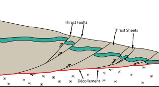
Thrust tectonics or contractional tectonics is concerned with the structures formed by, and the tectonic processes associated with, the shortening and thickening of the crust or lithosphere. It is one of the three main types of tectonic regime, the others being extensional tectonics and strike-slip tectonics. These match the three types of plate boundary, convergent (thrust), divergent (extensional) and transform (strike-slip). There are two main types of thrust tectonics, thin-skinned and thick-skinned, depending on whether or not basement rocks are involved in the deformation. The principle geological environments where thrust tectonics is observed are zones of continental collision, restraining bends on strike-slip faults and as part of detached fault systems on some passive margins.

The Jan Mayen Microcontinent is a fragment of continental crust within the oceanic part of the western Eurasian Plate lying northeast of Iceland. At the onset of separation between the Greenland and Eurasian plates 55 million years ago, it formed part of the eastern margin of the Greenland Plate. Propagation of a new spreading center from the Reykjanes Ridge separated this microcontinent from the Greenland Plate. For a short period it formed a microplate, until the Aegir Ridge became inactive, after which it formed part of the Eurasian Plate. The island of Jan Mayen is a much younger feature, formed of volcanic rock, built up at the northernmost tip of the microcontinent.
Mining is an important industry in Pakistan. Pakistan has deposits of several minerals including coal, copper, gold, chromite, mineral salt, bauxite and several other minerals. There are also a variety of precious and semi-precious minerals that are also mined. These include peridot, aquamarine, topaz, ruby, emerald, rare-earth minerals bastnaesite and xenotime, sphene, tourmaline, and many varieties and types of quartz.

The topography of Pakistan is divided into seven geographic areas: the northern highlands, the Indus River plain, the desert areas, the Pothohar Plateau, Balochistan Plateau, Salt Range, and the Sistan Basin. All the rivers of Pakistan, i.e. Sindh, Ravi River, Chenab River, Jhelum River, and Sutlej River, originate from the Himalayas mountain range. Some geographers designate Plateau as to the west of the imaginary southwest line; and the Indus Plain lies to the east of that line.
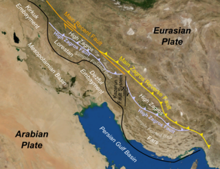
The Zagros fold and thrust belt is an approximately 1,800-kilometre (1,100 mi) long zone of deformed crustal rocks, formed in the foreland of the collision between the Arabian Plate and the Eurasian Plate. It is host to one of the world's largest petroleum provinces, containing about 49% of the established hydrocarbon reserves in fold and thrust belts (FTBs) and about 7% of all reserves globally.

There are many types of gemstones of Pakistan. They can be found among the nation's three mountain ranges - the Hindu Kush, the Himalayas, and the Karakoram - in the provinces of Khyber Pakhtunkhwa, Gilgit-Baltistan, Balochistan, and the Federally Administered Tribal Areas. The gemstone industry in Pakistan has the city of Peshawar as its hub, and there are many companies working in it.

The Persian Gulf Basin is found between the Eurasian and the Arabian Plate. The Persian Gulf is described as a shallow marginal sea of the Indian Ocean that is located between the south western side of Zagros Mountains and the Arabian Peninsula and south and southeastern side of Oman and the United Arab Emirates. Other countries that border the Persian Gulf basin include; Saudi Arabia, Qatar, Kuwait, Bahrain and Iraq. The Persian Gulf extends a distance of 1,000 km (620 mi) with an area of 240,000 km2 (93,000 sq mi). The Arabian Plate basin a wedge-shaped foreland basin which lies beneath the western Zagros thrust and was created as a result of the collision between the Arabian and Eurasian plates.

The offshore Indus Basin is one of the two basins in offshore Pakistan, the other one being the offshore Makran Basin. The Murray Ridge separates the two basins. The offshore Indus basin is approximately 120 to 140 kilometers wide and has an areal extent of ~20,000 square km.

The Kutai sedimentary basin extends from the central highlands of Borneo, across the eastern coast of the island and into the Makassar Strait. With an area of 60,000 km2, and depths up to 15 km, the Kutai is the largest and deepest Tertiary age basin in Indonesia. Plate tectonic evolution in the Indonesian region of SE Asia has produced a diverse array of basins in the Cenozoic. The Kutai is an extensional basin in a general foreland setting. Its geologic evolution begins in the mid Eocene and involves phases of extension and rifting, thermal sag, and isostatic subsidence. Rapid, high volume, sedimentation related to uplift and inversion began in the Early Miocene. The different stages of Kutai basin evolution can be roughly correlated to regional and local tectonic events. It is also likely that regional climate, namely the onset of the equatorial ever wet monsoon in early Miocene, has affected the geologic evolution of Borneo and the Kutai basin through the present day. Basin fill is ongoing in the lower Kutai basin, as the modern Mahakam River delta progrades east across the continental shelf of Borneo.
The Halibut Field is an oil field, within the Gippsland Basin offshore of the Australian state of Victoria. The oil field is located approximately 64 km offshore of southeastern Australia. The total area of this field is 26.9 km2 and is composed of 10 mappable units.

The Delta Field is located offshore from Nigeria on Oil Mining Leases (OML) 49 and 95. This is located within the Niger Delta Basin and sits in 12 feet of water. In 1965, the Delta 1 well was completed and the Delta Field opened in 1968 for production.
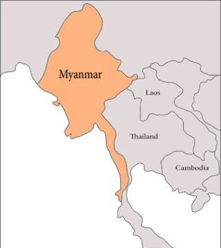
The geology of Myanmar is shaped by dramatic, ongoing tectonic processes controlled by shifting tectonic components as the Indian plate slides northwards and towards Southeast Asia. Myanmar spans across parts of three tectonic plates separated by north-trending faults. To the west, a highly oblique subduction zone separates the offshore Indian plate from the Burma microplate, which underlies most of the country. In the center-east of Myanmar, a right lateral strike slip fault extends from south to north across more than 1,000 km (620 mi). These tectonic zones are responsible for large earthquakes in the region. The India-Eurasia plate collision which initiated in the Eocene provides the last geological pieces of Myanmar, and thus Myanmar preserves a more extensive Cenozoic geological record as compared to records of the Mesozoic and Paleozoic eras. Myanmar is physiographically divided into three regions: the Indo-Burman Range, Myanmar Central Belt and the Shan Plateau; these all display an arcuate shape bulging westwards. The varying regional tectonic settings of Myanmar not only give rise to disparate regional features, but they also foster the formation of petroleum basins and a diverse mix of mineral resources.

The Bolivar Coastal Fields (BCF), also known as the Bolivar Coastal Complex, is located on the eastern margin of Lake Maracaibo, Venezuela. Bolivar Coastal Field is the largest oil field in South America with its 6,000-7,000 wells and forest of related derricks, stretches thirty-five miles along the north-east coast of Lake Maracaibo. They form the largest oil field outside of the Middle East and contain mostly heavy oil with a gravity less than 22 degrees API. Also known as the Eastern Coast Fields, Bolivar Coastal Oil Field consists of Tía Juana, Lagunillas, Bachaquero, Ceuta, Motatán, Barua and Ambrosio. The Bolivar Coast field lies in the Maracaibo dry forests ecoregion, which has been severely damaged by farming and ranching as well as oil exploitation. The oil field still plays an important role in production from the nation with approximately 2.6 million barrels of oil a day. It is important to note that the oil and gas industry refers to the Bolivar Coastal Complex as a single oilfield, in spite of the fact that the oilfield consists of many sub-fields as stated above.
The 1992 Kohat earthquake struck Khyber Pakhtunkhwa Province in Pakistan on May 20. The Mw 6.3 earthquake inflicted significant damage in the nearby city Kohat. An estimated 36 people died and 100 were injured in the Peshawar and Kohat districts. Four-hundred (400) homes were wiped out, affecting 2,100 residents in the region.
An earthquake struck Khyber Pakhtunkhwa Province, Pakistan on February 14, 2004. Extensive damage occurred and 24 people lost their lives.

