Geologic history, stratigraphy and tectonics
Uzbekistan's Variscan Paleozoic basement rock is divided into eight main zones. The Karakum-Tajik microcontinent has four tectonic zones in the metamorphic basement rock. The lower units of the southern Baysoon Unit are mainly late Proterozoic high-pressure metamorphic rocks—mainly meta-ultramafic or meta-acidic, gray and coarse. The exact origin of these rocks is uncertain, although they are inferred to have originated from island arc volcanism. They are overlain by unmetamorphosed carbonates from the late Silurian through the middle Devonian, with an angular unconformity at the base. Another angular unconformity above separates these rocks from volcanic and continental sedimentary rocks, with 300 metres (980 ft) thick conglomerate at the base, ascending to pebbly limestone and metamorphic rocks. The upper unit is a 1.5 kilometres (4,900 ft) thick cooled lava and tuff overlain by sandstone, conglomerate and Carboniferous plant remnants.
The tectonic zone to the north has greater meta-pelagic rock presence and rare fossils from the Cambrian. The two peaks of metamorphic activity in the Karakum-Tajik microcontinent is associated with the time when the oceanic crust of the Turkestan Ocean subducted beneath the edge of the microcontinent. Collision with the Kazakh microcontinent produced a second pulse of metamorphism.
Metamorphic rocks are present at the base of volcanic rocks, along with recrystallized limestone. Basalt lava flows, tuff, limestone and sandstone from the early and middle Carboniferous overlie these rocks, with a thickness of three kilometers. Diabase dikes, gabbro and serpentinite are also common. In Uzbekistan's paleo-rift zone, volcanic rocks and gabbro are up to 7 kilometres (23,000 ft) thick, dropping to 2 kilometres (6,600 ft) around the edges of the zone.
The Karakum-Tajik microcontinent's other two zones cold high-temperature, but low-pressure metamorphic ophiolite complexes, overlain by Ordovician and Silurian flysch, tuff, andesite lava and shallow-water sandstone. In turn, these units are overlain by a thick carbonate sequence up to 3 kilometres (9,800 ft) thick.
Rocks left over from the Turkestan Ocean crust form allochthon units on the northern edge of the Karakum-Tajik microcontinent. In the western part of the Turkestan structure, in the Kyzylkum Desert, andesite lava flows and tuff overlie Ordovician-Silurian carbonate and pelite. Nappe formations, such as the Kulkuduk Unit are composed of basal serptinized dunite and lherzolite, with overlying harzburgite and layered gabbro. These are cut by granite dikes and intrusions and are overlain by tube basalt, pillow basalt and sedimentary rocks such as ophiolite breccia, green and red pelagic shales, limestone and olistoliths.
Geologists separate the Kazakh microcontinent into two zones: the Tamdy and Kurama units. The base of the Tamdy Unit is metabasic and metasedimentary rocks ranging from a few hundred meters to a few kilometers thick and reaching blueschist grade on the sequence of metamorphic facies. The lowermost unit is a serpentinized ultramafic mélange with eclogite fragments. It underlies Silurian-Devonian terrestrial and carbonate sedimentary rocks. These rocks are overlain by conglomerate and flysch from the Carboniferous, as well as acid tuff and Permian continental conglomerates.
By contrast, the Kurama Unit has Proterozoic paragneiss, orthogneiss and granite intrusions in its basement rocks. Isotope dating indicates ages ranging from 1.9 billion to 230 million years ago for the metamorphic rocks. Vendian age sandstone and conglomerate intercalate with basalt, limestone and tuff, unconformably overlying the basement rock. Typically, these units are one to two kilometers thick. The Kurama Unit has volcanic rocks from the Ordovician, Silurian turbidites and andesite flows. An angular unconformity separates these rocks from a Devonian molasse unit, striking to the northeast with layers of andesite and tuff and overlain by a 1 kilometre (3,300 ft) Devonian to Carboniferous carbonate unit. A 6 kilometres (20,000 ft) volcanic unit caps the sequence, extending into Early Triassic age.
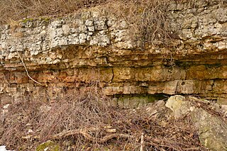
Sedimentary rocks deposited on top of the two microcontinents beginning in the Mesozoic. Faulting during the Triassic through the Early Cretaceous limited deposition to only a few small depressions. Sandstone, shale and conglomerate from the Triassic are found in the Ustyurt Plateau and southern Uzbekistan, containing units of bauxite deposited above an unconformity. Particularly in the Fergana Basin and the Kughitang and Zaravshansky ridges or the Gasly-Bukhara Depression, Jurassic coal and fine grained sedimentary rocks are more common, with thicknesses of 150 to 300 meters. Late Jurassic deposits are similar in thickness and include cross-bedded sandstone and conglomerate.
Cretaceous rocks are most common in the Kyzylkum Desert, Gissar-Kughitang, Bukhara-Kiva Depression, Fergana Valley and around Tashkent, with carbonates, sandstones and red shales up to 900 metres (3,000 ft) thick. Aptian and Albian age (based on marine fossils) gray sandstone, limestone and shale are more common in the west and south.
In southern Uzbekistan, they are notable as oil and gas-bearing reservoir formations. Copper-rich sandstone is found close to the Gissar area. Except in the east, where bauxite and continental sandstone formed, the Cretaceous immersed Uzbekistan in a shallow sea that left behind limestone and gypsum.
With the beginning of the Cenozoic, in the Paleogene deposition changed leaving behind a sequence with thick green clay at the base, overlain by limestone and then sandstone and clay in the east. In the middle Paleogene, 500 metres (1,600 ft) thick sequences of gypsum and carbonate overlain by 600 metres (2,000 ft) of clay, sandstone and carbonate formed in other parts of the country, producing oil and gas in the lowest unit.
The thickest sedimentary rocks in the platform cover are from the Neogene. The lower unit, dubbed E type, includes sandstone, shale and conglomerate with layers of gypsum and salt. It is about 600 metres (2,000 ft) thick, dating to the Miocene and Pliocene, much of it formed in lake environments. The Middle Pliocene unit is up to 3.4 kilometers thick and deposited in connection with rapid uplift of the Tien Shan mountains. The second type of sedimentation—W type—includes one kilometer of lacustrine carbonate with small layers of gypsum, sandstone and salt, as well as a 500 to 700 metres (1,600 to 2,300 ft) top unit of red shale and sandstone.
During the last 2.5 million years in the Quaternary, sedimentary rocks deposited in river valleys, and repeating layers with conglomerate at the base ascending to sandstone and shale indicate four different phases of uplift. The Kyzylkum (or "red sand") Desert has 5 to 60 metres (16 to 197 ft) thick red sand dunes from the Quaternary.

The Pyrenees are a 430-kilometre-long, roughly east–west striking, intracontinental mountain chain that divide France, Spain, and Andorra. The belt has an extended, polycyclic geological evolution dating back to the Precambrian. The chain's present configuration is due to the collision between the microcontinent Iberia and the southwestern promontory of the European Plate. The two continents were approaching each other since the onset of the Upper Cretaceous (Albian/Cenomanian) about 100 million years ago and were consequently colliding during the Paleogene (Eocene/Oligocene) 55 to 25 million years ago. After its uplift, the chain experienced intense erosion and isostatic readjustments. A cross-section through the chain shows an asymmetric flower-like structure with steeper dips on the French side. The Pyrenees are not solely the result of compressional forces, but also show an important sinistral shearing.
The geology of Niger comprises very ancient igneous and metamorphic crystalline basement rocks in the west, more than 2.2 billion years old formed in the late Archean and Proterozoic eons of the Precambrian. The Volta Basin, Air Massif and the Iullemeden Basin began to form in the Neoproterozoic and Paleozoic, along with numerous ring complexes, as the region experienced events such as glaciation and the Pan-African orogeny. Today, Niger has extensive mineral resources due to complex mineralization and laterite weathering including uranium, molybdenum, iron, coal, silver, nickel, cobalt and other resources.
The geology of Morocco formed beginning up to two billion years ago, in the Paleoproterozoic and potentially even earlier. It was affected by the Pan-African orogeny, although the later Hercynian orogeny produced fewer changes and left the Maseta Domain, a large area of remnant Paleozoic massifs. During the Paleozoic, extensive sedimentary deposits preserved marine fossils. Throughout the Mesozoic, the rifting apart of Pangaea to form the Atlantic Ocean created basins and fault blocks, which were blanketed in terrestrial and marine sediments—particularly as a major marine transgression flooded much of the region. In the Cenozoic, a microcontinent covered in sedimentary rocks from the Triassic and Cretaceous collided with northern Morocco, forming the Rif region. Morocco has extensive phosphate and salt reserves, as well as resources such as lead, zinc, copper and silver.
The geology of Ohio formed beginning more than one billion years ago in the Proterozoic eon of the Precambrian. The igneous and metamorphic crystalline basement rock is poorly understood except through deep boreholes and does not outcrop at the surface. The basement rock is divided between the Grenville Province and Superior Province. When the Grenville Province crust collided with Proto-North America, it launched the Grenville orogeny, a major mountain building event. The Grenville mountains eroded, filling in rift basins and Ohio was flooded and periodically exposed as dry land throughout the Paleozoic. In addition to marine carbonates such as limestone and dolomite, large deposits of shale and sandstone formed as subsequent mountain building events such as the Taconic orogeny and Acadian orogeny led to additional sediment deposition. Ohio transitioned to dryland conditions in the Pennsylvanian, forming large coal swamps and the region has been dryland ever since. Until the Pleistocene glaciations erased these features, the landscape was cut with deep stream valleys, which scoured away hundreds of meters of rock leaving little trace of geologic history in the Mesozoic and Cenozoic.
The geology of Arizona began to form in the Precambrian. Igneous and metamorphic crystalline basement rock may have been much older, but was overwritten during the Yavapai and Mazatzal orogenies in the Proterozoic. The Grenville orogeny to the east caused Arizona to fill with sediments, shedding into a shallow sea. Limestone formed in the sea was metamorphosed by mafic intrusions. The Great Unconformity is a famous gap in the stratigraphic record, as Arizona experienced 900 million years of terrestrial conditions, except in isolated basins. The region oscillated between terrestrial and shallow ocean conditions during the Paleozoic as multi-cellular life became common and three major orogenies to the east shed sediments before North America became part of the supercontinent Pangaea. The breakup of Pangaea was accompanied by the subduction of the Farallon Plate, which drove volcanism during the Nevadan orogeny and the Sevier orogeny in the Mesozoic, which covered much of Arizona in volcanic debris and sediments. The Mid-Tertiary ignimbrite flare-up created smaller mountain ranges with extensive ash and lava in the Cenozoic, followed by the sinking of the Farallon slab in the mantle throughout the past 14 million years, which has created the Basin and Range Province. Arizona has extensive mineralization in veins, due to hydrothermal fluids and is notable for copper-gold porphyry, lead, zinc, rare minerals formed from copper enrichment and evaporites among other resources.
The geology of Georgia is the study of rocks, minerals, water, landforms and geologic history in Georgia. The country is dominated by the Caucasus Mountains at the junction of the Eurasian Plate and the Afro-Arabian Plate, and rock units from the Mesozoic and Cenozoic are particularly prevalent. For much of its geologic history, until the uplift of the Caucasus, Georgia was submerged by marine transgression events. Geologic research for 150 years by Georgian and Russian geologists has shed significant light on the region and since the 1970s has been augmented with the understanding of plate tectonics.

The geology of Bosnia & Herzegovina is the study of rocks, minerals, water, landforms and geologic history in the country. The oldest rocks exposed at or near the surface date to the Paleozoic and the Precambrian geologic history of the region remains poorly understood. Complex assemblages of flysch, ophiolite, mélange and igneous plutons together with thick sedimentary units are a defining characteristic of the Dinaric Alps, also known as the Dinaride Mountains, which dominate much of the country's landscape.

The geology of Moldova encompasses basement rocks from the Precambrian dating back more than 2.5 billion years, overlain by thick sequences of Proterozoic, Paleozoic, Mesozoic and Cenozoic sedimentary rocks.
The geology of Utah, in the western United States, includes rocks formed at the edge of the proto-North American continent during the Precambrian. A shallow marine sedimentary environment covered the region for much of the Paleozoic and Mesozoic, followed by dryland conditions, volcanism, and the formation of the basin and range terrain in the Cenozoic.
The geology of Montana includes thick sequences of Paleozoic, Mesozoic and Cenozoic sedimentary rocks overlying ancient Archean and Proterozoic crystalline basement rock. Eastern Montana has considerable oil and gas resources, while the uplifted Rocky Mountains in the west, which resulted from the Laramide orogeny and other tectonic events have locations with metal ore.

The geology of Kazakhstan includes extensive basement rocks from the Precambrian and widespread Paleozoic rocks, as well as sediments formed in rift basins during the Mesozoic.
The geology of Laos includes poorly defined oldest rocks. Marine conditions persisted for much of the Paleozoic and parts of the Mesozoic, followed by periods of uplift and erosion. The country has extensive salt, gypsum and potash, but very little hydrocarbons and limited base metals.
The geology of Afghanistan includes nearly one billion year old rocks from the Precambrian. The region experienced widespread marine transgressions and deposition during the Paleozoic and Mesozoic, that continued into the Cenozoic with the uplift of the Hindu Kush mountains.
The geology of Thailand includes deep crystalline metamorphic basement rocks, overlain by extensive sandstone, limestone, turbidites and some volcanic rocks. The region experienced complicated tectonics during the Paleozoic, long-running shallow water conditions and then renewed uplift and erosion in the past several million years ago.

The geology of Slovakia is structurally complex, with a highly varied array of mountain ranges and belts largely formed during the Paleozoic, Mesozoic and Cenozoic eras.
The geology of Lithuania consists of ancient Proterozoic basement rock overlain by thick sequences of Paleozoic, Mesozoic and Cenozoic marine sedimentary rocks, with some oil reserves, abundant limestone, dolomite, phosphorite and glauconite. Lithuania is a country in the Baltic region of northern-eastern Europe.
Geology of Latvia includes an ancient Archean and Proterozoic crystalline basement overlain with Neoproterozoic volcanic rocks and numerous sedimentary rock sequences from the Paleozoic, some from the Mesozoic and many from the recent Quaternary past. Latvia is a country in the Baltic region of Northern Europe.
The geology of Greece is highly structurally complex due to its position at the junction between the European and African tectonic plates.
The geology of Saudi Arabia includes Precambrian igneous and metamorphic basement rocks, exposed across much of the country. Thick sedimentary sequences from the Phanerozoic dominate much of the country's surface and host oil.
The geology of Yukon includes sections of ancient Precambrian Proterozoic rock from the western edge of the proto-North American continent Laurentia, with several different island arc terranes added through the Paleozoic, Mesozoic and Cenozoic, driving volcanism, pluton formation and sedimentation.
