Related Research Articles

The Sydney Basin is an interim Australian bioregion and is both a structural entity and a depositional area, now preserved on the east coast of New South Wales, Australia and with some of its eastern side now subsided beneath the Tasman Sea. The basin is named for the city of Sydney, on which it is centred.
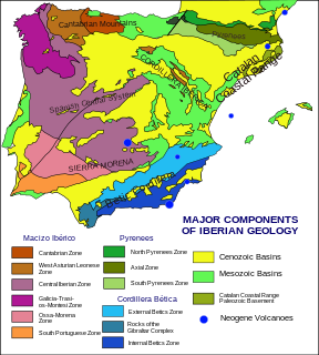
The geology of the Iberian Peninsula consists of the study of the rock formations on the Iberian Peninsula, which includes Spain, Portugal, Andorra, and Gibraltar. The peninsula contains rocks from every geological period from the Ediacaran to the Quaternary, and many types of rock are represented. World-class mineral deposits are also found there.
The Aquitaine Basin is the second largest Mesozoic and Cenozoic sedimentary basin in France after the Paris Basin, occupying a large part of the country's southwestern quadrant. Its surface area covers 66,000 km2 onshore. It formed on Variscan basement which was peneplained during the Permian and then started subsiding in the early Triassic. The basement is covered in the Parentis Basin and in the Subpyrenean Basin—both sub-basins of the main Aquitaine Basin—by 11,000 m of sediment.

The Pyrenees are a 430-kilometre-long, roughly east–west striking, intracontinental mountain chain that divide France, Spain, and Andorra. The belt has an extended, polycyclic geological evolution dating back to the Precambrian. The chain's present configuration is due to the collision between the microcontinent Iberia and the southwestern promontory of the European Plate. The two continents were approaching each other since the onset of the Upper Cretaceous (Albian/Cenomanian) about 100 million years ago and were consequently colliding during the Paleogene (Eocene/Oligocene) 55 to 25 million years ago. After its uplift, the chain experienced intense erosion and isostatic readjustments. A cross-section through the chain shows an asymmetric flower-like structure with steeper dips on the French side. The Pyrenees are not solely the result of compressional forces, but also show an important sinistral shearing.

The Columbus Basin is a foreland basin located off the south eastern coast of Trinidad within the East Venezuela Basin (EVB). Due to the intensive deformation occurring along the Caribbean and South American plates in this region, the basin has a unique structural and stratigraphic relationship. The Columbus Basin has been a prime area for hydrocarbon exploration and production as its structures, sediments and burial history provide ideal conditions for generation and storage of hydrocarbon reserves. The Columbus Basin serves as a depocenter for the Orinoco River delta, where it is infilled with 15 km of fluvio-deltaic sediment. The area has also been extensively deformed by series of north west to southeast normal faults and northeast to southwest trending anticline structures.

The offshore Indus Basin is one of the two basins in offshore Pakistan, the other one being the offshore Makran Basin. The Murray Ridge separates the two basins. The offshore Indus basin is approximately 120 to 140 kilometers wide and has an areal extent of ~20,000 square km.

The Kutai sedimentary basin extends from the central highlands of Borneo, across the eastern coast of the island and into the Makassar Strait. With an area of 60,000 km2, and depths up to 15 km, the Kutai is the largest and deepest Tertiary age basin in Indonesia. Plate tectonic evolution in the Indonesian region of SE Asia has produced a diverse array of basins in the Cenozoic. The Kutai is an extensional basin in a general foreland setting. Its geologic evolution begins in the mid Eocene and involves phases of extension and rifting, thermal sag, and isostatic subsidence. Rapid, high volume, sedimentation related to uplift and inversion began in the Early Miocene. The different stages of Kutai basin evolution can be roughly correlated to regional and local tectonic events. It is also likely that regional climate, namely the onset of the equatorial ever wet monsoon in early Miocene, has affected the geologic evolution of Borneo and the Kutai basin through the present day. Basin fill is ongoing in the lower Kutai basin, as the modern Mahakam River delta progrades east across the continental shelf of Borneo.
The Tarfaya Basin is a structural basin located in southern Morocco that extends westward into the Moroccan territorial waters in the Atlantic Ocean. The basin is named for the city of Tarfaya located near the border of Western Sahara, a region governed by the Kingdom of Morocco. The Canary Islands form the western edge of the basin and lie approximately 100 km to the west.
The Wessex Basin is a petroleum-bearing geological area located along the southern coast of England and extending into the English Channel. The onshore part of the basin covers approximately 20,000 km2 and the area that encompasses the English Channel is of similar size. The basin is a rift basin that was created during the Permian to early Cretaceous in response to movement of the African plate relative to the Eurasian plate. In the late Cretaceous, and again in the Cenozoic, the basin was inverted as a distant effect of the Alpine orogeny. The basin is usually divided into 3 main sub-basins including the Winterborne-Kingston Trough, Channel Basin, and Vale of Pewsey Basin. The area is also rich in hydrocarbons with several offshore wells in the area. With the large interest in the hydrocarbon exploration of the area, data became more readily available, which improved the understanding of the type of inversion tectonics that characterize this basin.

The geology of Lebanon remains poorly studied prior to the Jurassic. The country is heavily dominated by limestone, sandstone, other sedimentary rocks, and basalt, defined by its tectonic history. In Lebanon, 70% of exposed rocks are limestone karst.
The geology of South Dakota began to form more than 2.5 billion years ago in the Archean eon of the Precambrian. Igneous crystalline basement rock continued to emplace through the Proterozoic, interspersed with sediments and volcanic materials. Large limestone and shale deposits formed during the Paleozoic, during prevalent shallow marine conditions, followed by red beds during terrestrial conditions in the Triassic. The Western Interior Seaway flooded the region, creating vast shale, chalk and coal beds in the Cretaceous as the Laramide orogeny began to form the Rocky Mountains. The Black Hills were uplifted in the early Cenozoic, followed by long-running periods of erosion, sediment deposition and volcanic ash fall, forming the Badlands and storing marine and mammal fossils. Much of the state's landscape was reworked during several phases of glaciation in the Pleistocene. South Dakota has extensive mineral resources in the Black Hills and some oil and gas extraction in the Williston Basin. The Homestake Mine, active until 2002, was a major gold mine that reached up to 8000 feet underground and is now used for dark matter and neutrino research.
The geology of Alaska includes Precambrian igneous and metamorphic rocks formed in offshore terranes and added to the western margin of North America from the Paleozoic through modern times. The region was submerged for much of the Paleozoic and Mesozoic and formed extensive oil and gas reserves due to tectonic activity in the Arctic Ocean. Alaska was largely ice free during the Pleistocene, allowing humans to migrate into the Americas.
The geology of Nevada began to form in the Proterozoic at the western margin of North America. Terranes accreted to the continent as a marine environment dominated the area through the Paleozoic and Mesozoic periods. Intense volcanism, the horst and graben landscape of the Basin and Range Province originating from the Farallon Plate, and both glaciers and valley lakes have played important roles in the region throughout the past 66 million years.
The geology of Kyrgyzstan began to form during the Proterozoic. The country has experienced long-running uplift events, forming the Tian Shan mountains and large, sediment filled basins.
The geology of Thailand includes deep crystalline metamorphic basement rocks, overlain by extensive sandstone, limestone, turbidites and some volcanic rocks. The region experienced complicated tectonics during the Paleozoic, long-running shallow water conditions and then renewed uplift and erosion in the past several million years ago.

The geology of Bulgaria consists of two major structural features. The Rhodope Massif in southern Bulgaria is made up of Archean, Proterozoic and Cambrian rocks and is a sub-province of the Thracian-Anatolian polymetallic province. It has dropped down, faulted basins filled with Cenozoic sediments and volcanic rocks. The Moesian Platform to the north extends into Romania and has Paleozoic rocks covered by rocks from the Mesozoic, typically buried by thick Danube River valley Quaternary sediments. In places, the Moesian Platform has small oil and gas fields. Bulgaria is a country in southeastern Europe. It is bordered by Romania to the north, Serbia and North Macedonia to the west, Greece and Turkey to the south, and the Black Sea to the east.
The geology of Greece is highly structurally complex due to its position at the junction between the European and African tectonic plates.
The geology of Denmark includes 12 kilometers of unmetamorphosed sediments lie atop the Precambrian Fennoscandian Shield, the Norwegian-Scottish Caledonides and buried North German-Polish Caledonides. The stable Fennoscandian Shield formed from 1.45 billion years ago to 850 million years ago in the Proterozoic. The Fennoscandian Border Zone is a large fault, bounding the deep basement rock of the Danish Basin—a trough between the Border Zone and the Ringkobing-Fyn High. The Sorgenfrei-Tornquist Zone is a fault-bounded area displaying Cretaceous-Cenozoic inversion.
The geology of the United Arab Emirates includes very thick Paleozoic, Mesozoic and Cenozoic marine and continental sedimentary rocks overlying deeply buried Precambrian. The region has extensive oil and gas resources and was deformed during the last several million years by more distant tectonic events.

The geology of Italy includes mountain ranges such as the Alps, the Dolomites and the Apennines formed from the uplift of igneous and primarily marine sedimentary rocks all formed since the Paleozoic. Some active volcanoes are located in Insular Italy.
References
- ↑ Timothy A. Reed; Michael E. M. de Smet; Bhakti H. Harahap; Afin Sjapawi (1996). "Structural and Depositional History of East Timor". Geological Magazine.