Related Research Articles

Marl is an earthy material rich in carbonate minerals, clays, and silt. When hardened into rock, this becomes marlstone. It is formed in marine or freshwater environments, often through the activities of algae.
Alluvium is loose clay, silt, sand, or gravel that has been deposited by running water in a stream bed, on a floodplain, in an alluvial fan or beach, or in similar settings. Alluvium is also sometimes called alluvial deposit. Alluvium is typically geologically young and is not consolidated into solid rock. Sediments deposited underwater, in seas, estuaries, lakes, or ponds, are not described as alluvium.

The Green River Formation is an Eocene geologic formation that records the sedimentation in a group of intermountain lakes in three basins along the present-day Green River in Colorado, Wyoming, and Utah. The sediments are deposited in very fine layers, a dark layer during the growing season and a light-hue inorganic layer in the dry season. Each pair of layers is called a varve and represents one year. The sediments of the Green River Formation present a continuous record of six million years. The mean thickness of a varve here is 0.18 mm, with a minimum thickness of 0.014 mm and maximum of 9.8 mm.
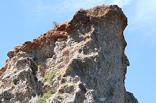
A geological formation, or simply formation, is a body of rock having a consistent set of physical characteristics (lithology) that distinguishes it from adjacent bodies of rock, and which occupies a particular position in the layers of rock exposed in a geographical region. It is the fundamental unit of lithostratigraphy, the study of strata or rock layers.

In geology, a facies is a body of rock with distinctive characteristics. The characteristics can be any observable attribute of rocks and the changes that may occur in those attributes over a geographic area. A facies encompasses all the characteristics of a rock including its chemical, physical, and biological features that distinguish it from adjacent rock.
The Serravallian is, in the geologic timescale, an age or a stage in the middle Miocene Epoch/Series, which spans the time between 13.82 Ma and 11.63 Ma. The Serravallian follows the Langhian and is followed by the Tortonian.

Relative dating is the science of determining the relative order of past events, without necessarily determining their absolute age. In geology, rock or superficial deposits, fossils and lithologies can be used to correlate one stratigraphic column with another. Prior to the discovery of radiometric dating in the early 20th century, which provided a means of absolute dating, archaeologists and geologists used relative dating to determine ages of materials. Though relative dating can only determine the sequential order in which a series of events occurred, not when they occurred, it remains a useful technique. Relative dating by biostratigraphy is the preferred method in paleontology and is, in some respects, more accurate. The Law of Superposition, which states that older layers will be deeper in a site than more recent layers, was the summary outcome of 'relative dating' as observed in geology from the 17th century to the early 20th century.

The geology of the Iberian Peninsula consists of the study of the rock formations on the Iberian Peninsula, which includes Spain, Portugal, Andorra, and Gibraltar. The peninsula contains rocks from every geological period from the Ediacaran to the Quaternary, and many types of rock are represented. World-class mineral deposits are also found there.
The following outline is provided as an overview of and topical guide to geology:

A geologist is a scientist who studies the solid, liquid, and gaseous matter that constitutes Earth and other terrestrial planets, as well as the processes that shape them. Geologists usually study geology, earth science, or geophysics, although backgrounds in physics, chemistry, biology, and other sciences are also useful. Field research is an important component of geology, although many subdisciplines incorporate laboratory and digitalized work. Geologists can be classified in a larger group of scientists, called geoscientists.
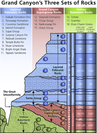
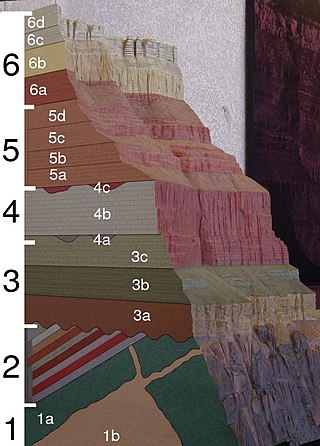
A stratigraphic column is a representation used in geology and its subfield of stratigraphy to describe the vertical location of rock units in a particular area. A typical stratigraphic column shows a sequence of sedimentary rocks, with the oldest rocks on the bottom and the youngest on top.

The Great Valley Sequence of California is a 40,000-foot (12 km)-thick group of related geologic formations that are Late Jurassic through Cretaceous in age on the geologic time scale. These sedimentary rocks were deposited during the late Mesozoic Era in an ancient seaway that corresponds roughly to the outline of the modern Great Valley of California.
The Poison Canyon Formation is a geologic formation in the Raton Basin of Colorado and New Mexico. The formation was deposited from the late Cretaceous through the Paleocene.
Navidad Formation is a marine Neogene sedimentary formation located in Central Chile. The formation is known for its diverse and abundant fossil record and is considered the reference unit for the marine Neogene in Chile. Originally described by Charles Darwin in 1846 the formation has attracted the attention of numerous prominent geologists and paleontologists since then. As a key formation Navidad has been subject to a series of differing interpretations and scientific disputes over time.
Hungary is in the Pannonian Basin in Central Europe, is surrounded by the Carpathians, Alps and Dinarides, but for the most part dominated by lowlands. Sixty-eight percent of the country is lowlands below 200 meters altitude. Hilly terrain covers 30% of the country, while mountains cover only 2%. The entire Pannonian Basin is in the Danube watershed.
The geology of Guinea-Bissau is oldest in the east and becomes younger toward the west, with sediments from the past 66 million years nearer the coast. Some rock units in the northeast are as much as 680 million years old and throughout the geologic past Guinea-Bissau was influenced by the Mauritanide Belt orogeny and was submerged or partially submerged as a marine shelf or river delta for most of its existence.
The geology of Liechtenstein formed at the intersection of the Eastern and Western Alps and the country occupies a wider than average river valley on the Rhine River, running north–south. A spur of the Ratikon Mountains flanks the river to the east, while Schellenberg hill is a defining topographic high in the north.
The geology of Brunei is primarily made up of Cenozoic rocks overlying deeper rock units on the island of Borneo. Rocks from the Oligocene through the Holocene are up to 15 kilometers thick.
The geology of Greece is highly structurally complex due to its position at the junction between the European and African tectonic plates.
The Laga Basin is the largest and youngest foreland basin of the Central Apennines fold and thrust belt. It is Messinian in age and serves as a link between an Early Miocene aged fold and thrust belt at the west of the Central Apennines and a younger belt to the east. In the 1980s and 1990s, it was the subject of numerous investigations for hydrocarbon resources, and since has become a valuable analogue with relation to clastic reservoirs developed in confined structural settings.
References
- ↑ Moores, E.M.; Fairbridge, Rhodes W. (1997). Encyclopedia of European & Asian Regional Geology. Springer. p. 653.