Geology of Sicily

Last updated

The geology of Sicily (a large island located at Italy's southwestern end) records the collision of the Eurasian and the African plates during westward-dipping subduction of the African slab since late Oligocene. [1] [2] Major tectonic units are the Hyblean foreland, the Gela foredeep, the Apenninic-Maghrebian orogen, and the Calabrian Arc. The orogen represents a fold-thrust belt that folds Mesozoic carbonates, while a major volcanic unit (Mt Etna) is found in an eastern portion of the island. [3] The collision of Africa and Eurasia is a retreating subduction system, such that the descending Africa is falling away from Eurasia, and Eurasia extends and fills the space as the African plate falls into the mantle, resulting in volcanic activity in Sicily and the formation of Tyrrhenian slab to the north. [4]

Contents

Major tectonic units

Hyblean foreland

Simplified geological map of Sicily Simplified geological map of Sicily (colour fixed).svg
Simplified geological map of Sicily

The foreland consists of exposures of the Hyblean Plateau and the offshore areas of Gela. The subduction forms a northward-dipping monocline in the foreland with a dip of 16–18°, which is a high angle compared to other regional monoclines. It is suggested that this steep angle is caused by a higher subductibility of the African slab. [6] Deformation in the foreland is dominated by normal faulting; most of these faults have been formed in the Neogene by plate flexure. Some of the faults are recognized to be much older, formed in the Mesozoic. The faults are suggested to have separated high-standing platforms from deeper basins. [8]

The simplified stratigraphy includes the following units: [6] [8]

AgeRock typeFormation environmentThickness
Late Pliocene–Early Pleistocene [8] Intermittent basalts [8]
Pliocene–Pleistocene [8] Chalk/ calcarenite [8]
Jurassic–Late Miocene [6] Limestone, w/ thick basalt interbedding [6] Platform slope and open-shelf [6] 1–2km [6]
Triassic–Early Jurassic [6] Limestone/

carbonate turbidites [6]

Shallow-water sea [6] 5–7km [6]

The post-Paleogene geological events of the foreland can be divided into four main stages:

Gela foredeep

The Gela foredeep extends from the northern margin of the Hyblean plateau on land to the offshore Gela basin of southwestern Sicily. Based on fossil analysis, the basin has been developing since Late Pliocene; its formation is related to the bending of the carbonate platform due to loading at the front of the Gela nappe. The basin fill consists of Late Miocene-Pleistocene sediments, including marly limestones, Messinian evaporites and sandy clays. [3]

Simplified cross-section of the Apenninic-Maghrebian chain Geological cross section of Sicily revised 20171221.svg
Simplified cross-section of the Apenninic-Maghrebian chain

The Apenninic-Maghrebian orogen

The central to western part of Sicily is made of the Maghrebian-Apenninic orogen and represents the fold and thrust belt of the subduction system. A combination of frontal accretion and low-angle detachments formed the present geological structure. [11] The orogen consists of a stack of detached nappes that involves mostly the Mesozoic carbonate, which has subsequently been folded into a syncline, underlying a broad anticline of the Caltanissetta area. [12]

The stratigraphy of the accretionary wedge is composed of the following units: [5] [6] [13]

Stratigraphic unitAgeThicknessRock typeFormation environmentStructures
Wedge-top deposits [6] Upper Miocene–Pleistocene [6] Marl/evaporites [6] Shallow water/arid environment [6]
Sicilide unit [6] Cretaceous–Early Tertiary [13] 200–300m [13] Carbonates [13] Pelagic zone/sedimentary basin [13] SW-&SE-vergent folds [6]
Numidian Flysch unit [6] Upper Oligocene–Lower Miocene [5] 1–1.5km [5] Clays/quartzarenites [5] Imbricate fans, SW-&SE-vergent folds [6]
Imerese/Sicanian unit [6] Permian-Cenozoic [6] >1.5km [6] Carbonates [6] Deep water [6] Antiformal stacks [6]
Transpanse–Saccense unit [6] Meso-Cenozoic [6] >5km [6] Limestone [6] Shallow water/pelagic zone [6] Imbricate fans [6]
Hyblean unit [6] Mesozoic [6] 7–8km [6] Limestone [6] Shallow water/pelagic zone [6] Imbricate fans, ached [6]

Calabrian crystalline basement

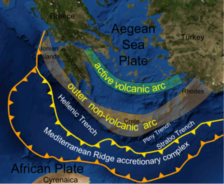
The northeastern part of Sicily consists of the Calabrian Arc unit, the tectonic unit that connects the Apennines with the North African Maghrebide. Paleozoic igneous and metamorphic basement rocks are exposed at this part of the island, suggested to have been exposed by exhumation processes between mid-Oligocene and Middle Miocene. [14] The rapid migration of the Calabrian Arc towards the southeast was driven by the retreat of the Ionian slab east of Sicily. [1] In early Miocene, Calabria was still attached to Sardinia. In Middle Miocene, the trench rolled back to the east and normal faulting occurred between Calabria and Sardinia, causing Calabria to split eastward from Sardinia. By Early Pliocene, the retreat of Calabria consumed the oceanic slab of the Ionian sea while new oceanic crust was created in the Tyrrhenian Sea by back-arc magmatism. Since Pleistocene, the eastern portion of the arc formed the Apennine mountain of Italy, while the Calabrian block slid to Sicily through right lateral strike-slip motion, forming the northeastern portion of the island. [1] GPS measurements show that the Calabrian Arc still advances to the southeast at 2-3mm per year at present, due to the ongoing rollback of the Ionian slab. [15]

The simplified stratigraphy consists of the following units: [3]

AgeRock type
Early PlioceneChalk
MessinianEvaporites
Middle Miocene-MessinianRift deposits/sandy marls
Paleogene-Middle MioceneArkosic Turbidites
Triassic-Late CretaceousCarbonate
PalaeozoicIgneous/Metamorphic (basement)
3-D geological model of subduction system and mantle flow of Mount Etna. The Ionian slab (green) is subducting beneath Tyrrhenian slab (blue), pulling magma under African slab (yellow) to the low pressure zone (pink) and upwell to form Mt. Etna. Mt Etna system cross section.svg
3-D geological model of subduction system and mantle flow of Mount Etna. The Ionian slab (green) is subducting beneath Tyrrhenian slab (blue), pulling magma under African slab (yellow) to the low pressure zone (pink) and upwell to form Mt. Etna.
Mount Etna. Etna in wintertime.jpg
Mount Etna.

Mount Etna

Mount Etna is an active stratovolcano located at the eastern coast of Sicily which is composed mainly of basalt. Its formation began at about 0.5 Ma when submarine volcanism occurred at the Gela foredeep and formed tholeiitic pillow lava. At about 0.3 Ma, a tholeiitic lava plateau was formed on an ancient alluvial plain by fissure-type volcanism. From 0.22 Ma, volcanism mainly occurred at the Ionian coast which formed an alkaline shield volcano with length of 15 km at the N-S direction, until volcanism shifted westward to the current location of Mt. Etna at about 129 ka. Finally, central-vent type volcanism began with the formation of two small parasitic cones, which the eruption of these two cones ended at 106 and 102 ka. [4] It is suggested that the formation of Mount Etna is closely related to the subduction system of Sicily. Although the magma does not originate from the subducted material, the retreat of African slab creates a low-pressure zone at the mantle wedge under Calabria, which pulls the asthenospheric material under the African plate laterally towards the northeast. This process produces a large volume of magma that caused upwelling under Mount Etna, as well as the regional uplift of the Calabrian unit. [16]

Tectonic history

The tectonic setting of Sicily is controlled by the rate of collision of the African plate and Eurasian plate and the rate of back rolling of the African plate. The tectonic history of Sicily can be divided into four main stages: [9]

Late Triassic–Early Jurassic period

During Late Triassic, the ancient Neotethys ocean was formed by a major continental rifting event and rapid tectonic subsidence. Traces of the tectonic event can be found at both the Hyblean plateau and western Sicily. [9]

Early Jurassic–Late Cretaceous period

Simplified evolutionary diagram of Sicily Evolutionary Diagram of Sicily (Revised on 20171113 19-00).svg
Simplified evolutionary diagram of Sicily

After the rapid subsidence during Triassic to Early Jurassic, there was a slow thermal subsidence at the Mediterranean basin from Jurassic to Late Cretaceous that formed the Neotethyan carbonate platform. [9]

Late Cretaceous–Palaeogene period

During Late Cretaceous and Palaeogene, the collision of African and Eurasian plates generated compressive stress in the region. The Neotethyan ocean was closed by the collision and the continental margin became active. [9]

Neogene–Quaternary period

Sicily has been undergoing a phase of uplifting and subduction since Neogene. [9] The African slab retreats to the east as the collision of Eurasian and African plate continued. [1] Since late Oligocene, the orogenic process started when sediments accreted onto the Calabrian block while flysch was deposited in the foreland basins. The Sardinia block then underwent counter-clockwise rotation and the Calabrian unit subsequently underwent clockwise rotation. During the Early–Middle Miocene, shallow seated thrusting occurred which formed the wedge-top basins. Since Late Miocene, thrusting occurred in the Sicilian orogen and Calabrian accretionary wedge. [2] Extension and back-arc magmatism occurred in the Tyrrhenian slab due to the fast roll back of the Ionian slab, while Calabria migrated to the current position at northeast Sicily. [1]

Mining

Sicily is known for its history of sulfur production. Sulfur mining was active until the 20th century. [18] The sulfur was extracted in a number of ways involving heating, melting and cooling the semi-purified sulfur in various approaches collectively called Sicilian method. Abandoned sulfur mines includes those in Castelterminin, Enna and Caltanissetta. The major ores were sulfur-bearing sedimentary deposits, formed during the Messinian Salinity Crisis, which thick layers of evaporites including gypsum and other evaporitic sulfur were deposited in the central Sicilian basin when the area was above sea level. These native sulfurs are associated with secondary carbonates and are suggested to be formed by intense microbial sulfate reduction, in which microorganisms 'breath in' sulfate instead of oxygen for anaerobic respiration. [19]

Related Research Articles

<span class="mw-page-title-main">Orogeny</span> The formation of mountain ranges

Orogeny is a mountain building process that takes place at a convergent plate margin when plate motion compresses the margin. An orogenic belt or orogen develops as the compressed plate crumples and is uplifted to form one or more mountain ranges. This involves a series of geological processes collectively called orogenesis. These include both structural deformation of existing continental crust and the creation of new continental crust through volcanism. Magma rising in the orogen carries less dense material upwards while leaving more dense material behind, resulting in compositional differentiation of Earth's lithosphere. A synorogenic process or event is one that occurs during an orogeny.

<span class="mw-page-title-main">Geology of the Alps</span> The formation and structure of the European Alps

The Alps form part of a Cenozoic orogenic belt of mountain chains, called the Alpide belt, that stretches through southern Europe and Asia from the Atlantic all the way to the Himalayas. This belt of mountain chains was formed during the Alpine orogeny. A gap in these mountain chains in central Europe separates the Alps from the Carpathians to the east. Orogeny took place continuously and tectonic subsidence has produced the gaps in between.

<span class="mw-page-title-main">Sevier orogeny</span> Mountain-building episode in North America

The Sevier orogeny was a mountain-building event that affected western North America from northern Canada to the north to Mexico to the south.

The Hunter-Bowen Orogeny was a significant arc accretion event in the Permian and Triassic periods affecting approximately 2,500 km of the Australian continental margin.

<span class="mw-page-title-main">Molasse basin</span> Foreland basin north of the Alps

The Molasse basin is a foreland basin north of the Alps which formed during the Oligocene and Miocene epochs. The basin formed as a result of the flexure of the European plate under the weight of the orogenic wedge of the Alps that was forming to the south.

<span class="mw-page-title-main">Foreland basin</span> Structural basin that develops adjacent and parallel to a mountain belt

A foreland basin is a structural basin that develops adjacent and parallel to a mountain belt. Foreland basins form because the immense mass created by crustal thickening associated with the evolution of a mountain belt causes the lithosphere to bend, by a process known as lithospheric flexure. The width and depth of the foreland basin is determined by the flexural rigidity of the underlying lithosphere, and the characteristics of the mountain belt. The foreland basin receives sediment that is eroded off the adjacent mountain belt, filling with thick sedimentary successions that thin away from the mountain belt. Foreland basins represent an endmember basin type, the other being rift basins. Space for sediments is provided by loading and downflexure to form foreland basins, in contrast to rift basins, where accommodation space is generated by lithospheric extension.

<span class="mw-page-title-main">Forebulge</span>

In geology, a forebulge is a flexural bulge in front as a result of a load on the lithosphere, often caused by tectonic interactions and glaciations. An example of forebulge can be seen in the Himalayan foreland basin, a result of the Indian-Eurasian (continent-continent) plate collision, in which the Indian plate subducted and the Eurasian plate created a large load on the lithosphere, leading to the Himalayas and the Ganges foreland basin.

<span class="mw-page-title-main">Gibraltar Arc</span>

The Gibraltar Arc is a geological region corresponding to an arcuate orogen surrounding the Alboran Sea, between the Iberian Peninsula and Africa. It consists of the Betic Cordillera, and the Rif. The Gibraltar Arc is located at the western end of the Mediterranean Alpine belt and formed during the Neogene due to convergence of the Eurasian and African plates.

<span class="mw-page-title-main">Rhenohercynian Zone</span> Fold belt of west and central Europe, formed during the Hercynian orogeny

The Rhenohercynian Zone or Rheno-Hercynian zone in structural geology describes a fold belt of west and central Europe, formed during the Hercynian orogeny. The zone consists of folded and thrust Devonian and early Carboniferous sedimentary rocks that were deposited in a back-arc basin along the southern margin of the then existing paleocontinent Laurussia.

<span class="mw-page-title-main">Geology of the Western Carpathians</span>

The Western Carpathians are an arc-shaped mountain range, the northern branch of the Alpine-Himalayan fold and thrust system called the Alpide belt, which evolved during the Alpine orogeny. In particular, their pre-Cenozoic evolution is very similar to that of the Eastern Alps, and they constitute a transition between the Eastern Alps and the Eastern Carpathians.

<span class="mw-page-title-main">Andean orogeny</span> Ongoing mountain-forming process in South America

The Andean orogeny is an ongoing process of orogeny that began in the Early Jurassic and is responsible for the rise of the Andes mountains. The orogeny is driven by a reactivation of a long-lived subduction system along the western margin of South America. On a continental scale the Cretaceous and Oligocene were periods of re-arrangements in the orogeny. The details of the orogeny vary depending on the segment and the geological period considered.

<span class="mw-page-title-main">Geology of Russia</span> Overview of the geology of Russia

<span class="mw-page-title-main">Carpathian Flysch Belt</span> Tectonic zone in the Carpathian Mountains

The Carpathian Flysch Belt is an arcuate tectonic zone included in the megastructural elevation of the Carpathians on the external periphery of the mountain chain. Geomorphologically it is a portion of the Outer Carpathians. Geologically it is a thin-skinned thrust belt or accretionary wedge, formed by rootless nappes consisting of so-called flysch – alternating marine deposits of claystones, shales and sandstones which were detached from their substratum and moved tens of kilometers to the north (generally). The Flysch Belt is together with Neogene volcanic complexes the only extant tectonic zone along the whole Carpathian arc.

The South China Sea Basin is one of the largest marginal basins in Asia. South China Sea is located to the east of Vietnam, west of Philippines and the Luzon Strait, and north of Borneo. Tectonically, it is surrounded by the Indochina Block on the west, Philippine Sea Plate on the east, Yangtze Block to the north. A subduction boundary exists between the Philippine Sea Plate and the Asian Plate. The formation of the South China Sea Basin was closely related with the collision between the Indian Plate and Eurasian Plates. The collision thickened the continental crust and changed the elevation of the topography from the Himalayan orogenic zone to the South China Sea, especially around the Tibetan Plateau. The location of the South China Sea makes it a product of several tectonic events. All the plates around the South China Sea Basin underwent clockwise rotation, subduction and experienced an extrusion process from the early Cenozoic to the Late Miocene.

The Tyrrhenian Basin is a sedimentary basin located in the western Mediterranean Sea under the Tyrrhenian Sea. It covers a 231,000 km2 area that is bounded by Sardinia to the west, Corsica to the northwest, Sicily to the southeast, and peninsular Italy to the northeast. The Tyrrhenian basin displays an irregular seafloor marked by several seamounts and two distinct sub-basins - the Vavilov and Marsili basins. The Vavilov deep plain contains the deepest point of the Tyrrhenian basin at approximately 3785 meters. The basin trends roughly northwest–southeast with the spreading axis trending northeast–southwest.

<span class="mw-page-title-main">Flat slab subduction</span> Subduction characterized by a low subduction angle

Flat slab subduction is characterized by a low subduction angle beyond the seismogenic layer and a resumption of normal subduction far from the trench. A slab refers to the subducting lower plate. A broader definition of flat slab subduction includes any shallowly dipping lower plate, as in western Mexico. Flat slab subduction is associated with the pinching out of the asthenosphere, an inland migration of arc magmatism, and an eventual cessation of arc magmatism. The coupling of the flat slab to the upper plate is thought to change the style of deformation occurring on the upper plate's surface and form basement-cored uplifts like the Rocky Mountains. The flat slab also may hydrate the lower continental lithosphere and be involved in the formation of economically important ore deposits. During the subduction, a flat slab itself may deform or buckle, causing sedimentary hiatus in marine sediments on the slab. The failure of a flat slab is associated with ignimbritic volcanism and the reverse migration of arc volcanism. Multiple working hypotheses about the cause of flat slabs are subduction of thick, buoyant oceanic crust (15–20 km) and trench rollback accompanying a rapidly overriding upper plate and enhanced trench suction. The west coast of South America has two of the largest flat slab subduction zones. Flat slab subduction is occurring at 10% of subduction zones.

<span class="mw-page-title-main">Geology of Italy</span> Overview of the geology of Italy

The geology of Italy includes mountain ranges such as the Alps and the Apennines formed from the uplift of igneous and primarily marine sedimentary rocks all formed since the Paleozoic. Some active volcanoes are located in Insular Italy.

<span class="mw-page-title-main">Junggar Basin</span>

The Junggar Basin is one of the largest sedimentary basins in Northwest China. It is located in Xinjiang, and enclosed by the Tarbagatai Mountains of Kazakhstan in the northwest, the Altai Mountains of Mongolia in the northeast, and the Heavenly Mountains in the south. The geology of Junggar Basin mainly consists of sedimentary rocks underlain by igneous and metamorphic basement rocks. The basement of the basin was largely formed during the development of the Pangea supercontinent during complex tectonic events from Precambrian to late Paleozoic time. The basin developed as a series of foreland basins – in other words, basins developing immediately in front of growing mountain ranges – from Permian time to the Quaternary period. The basin's preserved sedimentary records show that the climate during the Mesozoic era was marked by a transition from humid to arid conditions as monsoonal climatic effects waned. The Junggar basin is rich in geological resources due to effects of volcanism and sedimentary deposition. According to Guinness World Records it is a land location remotest from open sea with great-circle distance of 2,648 km from the nearest open sea at 46°16′8″N86°40′2″E.

<span class="mw-page-title-main">Hellenic subduction zone</span>

The Hellenic subduction zone (HSZ) is the convergent boundary between the African Plate and the Aegean Sea Plate, where oceanic crust of the African is being subducted north–northeastwards beneath the Aegean. The southernmost and shallowest part of the zone is obscured beneath the deformed thick sedimentary sequence that forms the Mediterranean Ridge accretionary complex. It has a well-defined Wadati–Benioff zone of seismicity, which demonstrates the relatively shallow dip of its southern part, which increases markedly to the north of the non-volcanic part of the Hellenic arc. The descending slab has been imaged using seismic tomography down to the top of the mantle transition zone at 410 km depth.

The Laga Basin is the largest and youngest foreland basin of the Central Apennines fold and thrust belt. It is Messinian in age and serves as a link between an Early Miocene aged fold and thrust belt at the west of the Central Apennines and a younger belt to the east. In the 1980s and 1990s, it was the subject of numerous investigations for hydrocarbon resources, and since has become a valuable analogue with relation to clastic reservoirs developed in confined structural settings.

References

  1. 1 2 3 4 5 Gvirtzman, Z., & Nur, A. (2001). Residual topography, lithospheric structure and sunken slabs in the central Mediterranean. Earth and Planetary Science Letters, 187(1), 117-130.
  2. 1 2 Di Maggio, C., Madonia, G., Vattano, M., Agnesi, V., & Monteleone, S. (2017). Geomorphological evolution of western Sicily, Italy. Geologica Carpathica, 68(1), 80-93.
  3. 1 2 3 Catalano, R., Lo Cicero, G., & Sulli, A. (2002, September). Geology of Sicily: an introduction. In General Field Trip Guidebook, 6th International Symposium on the Jurassic System(pp. 12-22).
  4. 1 2 Branca, S., Coltelli, M., De Beni, E., & Wijbrans, J. (2008). Geological evolution of Mount Etna volcano (Italy) from earliest products until the first central volcanism (between 500 and 100 ka ago) inferred from geochronological and stratigraphic data. International Journal of Earth Sciences, 97(1), 135-152.
  5. 1 2 3 4 5 Pipanl, M., & Prizzon, A. (2005). Geological outline of Sicily and lithospheric tectono-dynamics of its Tyrrhenian margin from new CROP seismic data. CROP PROJECT: Deep Seismic Exploration of the Central Mediterranean and Italy, 1, 319.
  6. 1 2 3 4 5 6 7 8 9 10 11 12 13 14 15 16 17 18 19 20 21 22 23 24 25 26 27 28 29 30 31 32 33 34 35 36 37 38 Catalano, R., Valenti, V., Albanese, C., Accaino, F., Sulli, A., Tinivella, U., ... & Giustiniani, M. (2013). Sicily’s fold–thrust belt and slab roll-back: the SI. RI. PRO. seismic crustal transect. Journal of the Geological Society, 170(3), 451-464.
  7. Brutto, F., Muto, F., Loreto, M. F., De Paola, N., Tripodi, V., Critelli, S., & Facchin, L. (2016). The Neogene-Quaternary geodynamic evolution of the central Calabrian Arc: A case study from the western Catanzaro Trough basin. Journal of Geodynamics, 102, 95-114.
  8. 1 2 3 4 5 6 Lickorish, W. H., Grasso, M., Butler, R. W., Argnani, A., & Maniscalco, R. (1999). Structural styles and regional tectonic setting of the “Gela Nappe” and frontal part of the Maghrebian thrust belt in Sicily. Tectonics, 18(4), 655-668.
  9. 1 2 3 4 5 6 7 8 9 Yellin-Dror, A., Grasso, M., Ben-Avraham, Z., & Tibor, G. (1997). The subsidence history of the northern Hyblean plateau margin, southeastern Sicily. Tectonophysics, 282(1-4), 277-289.
  10. Catalano, R., Valenti, V., Albanese, C., Accaino, F., Sulli, A., Tinivella, U., ... & Giustiniani, M. (2013). Sicily’s fold–thrust belt and slab roll-back: the SI. RI. PRO. seismic crustal transect. Journal of the Geological Society, 170(3), 451-464.
  11. Corrado, S., Aldega, L., Balestrieri, M. L., Maniscalco, R., & Grasso, M. (2009). Structural evolution of the sedimentary accretionary wedge of the alpine system in Eastern Sicily: Thermal and thermochronological constraints. Geological Society of America Bulletin, 121(11-12), 1475–1490.
  12. Catalano, R., Valenti, V., Albanese, C., Accaino, F., Sulli, A., Tinivella, U., ... & Giustiniani, M. (2013). Sicily’s fold–thrust belt and slab roll-back: the SI. RI. PRO. seismic crustal transect. Journal of the Geological Society, 170(3), 451-464.
  13. 1 2 3 4 5 Ślączka, A., Renda, P., Cieszkowski, M., Golonka, J., & Nigro, F. (2012). Sedimentary basins evolution and olistoliths formation: The case of Carpathian and Sicilian regions. Tectonophysics, 568, 306-319.
  14. Thomson, S. N. (1994). Fission track analysis of the crystalline basement rocks of the Calabrian Arc, southern Italy: evidence of Oligo-Miocene late-orogenic extension and erosion. Tectonophysics, 238(1-4), 331-352.
  15. Gallais, F., Graindorge, D., Gutscher, M. A., & Klaeschen, D. (2013). Propagation of a lithospheric tear fault (STEP) through the western boundary of the Calabrian accretionary wedge offshore eastern Sicily (Southern Italy). Tectonophysics, 602, 141-152.
  16. 1 2 Gvirtzman, Z., & Nur, A. (1999). The formation of Mount Etna as the consequence of slab rollback. Nature, 401(6755), 782-785.
  17. Gueguen, E., Doglioni, C., & Fernandez, M. (1998). On the post-25 Ma geodynamic evolution of the western Mediterranean. Tectonophysics, 298(1), 259-269.
  18. Ferrara, V. (2016). The Sulphur Mining Industry in Sicily. In Essays on the History of Mechanical Engineering (pp. 111-130). Springer International Publishing.
  19. Ziegenbalg, S. B., Brunner, B., Rouchy, J. M., Birgel, D., Pierre, C., Böttcher, M. E., ... & Peckmann, J. (2010). Formation of secondary carbonates and native sulphur in sulphate-rich Messinian strata, Sicily. Sedimentary Geology, 227(1), 37-50.