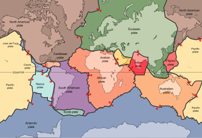
The Eurasian Plate is a tectonic plate that includes most of the continent of Eurasia, with the notable exceptions of the Indian subcontinent, the Arabian subcontinent and the area east of the Chersky Range in eastern Siberia. It also includes oceanic crust extending westward to the Mid-Atlantic Ridge and northward to the Gakkel Ridge.
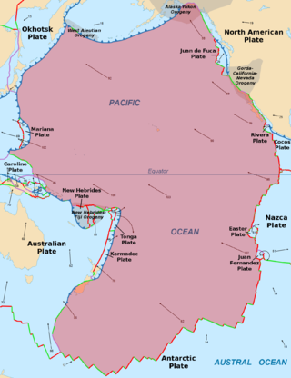
The Pacific Plate is an oceanic tectonic plate that lies beneath the Pacific Ocean. At 103 million km2 (40 million sq mi), it is the largest tectonic plate.

The Australian Plate is a major tectonic plate in the eastern and, largely, southern hemispheres. Originally a part of the ancient continent of Gondwana, Australia remained connected to India and Antarctica until approximately 100 million years ago when India broke away and began moving north. Australia and Antarctica had begun rifting by 96 million years ago and completely separated a while after this, some believing as recently as 45 million years ago, but most accepting presently that this had occurred by 60 million years ago.
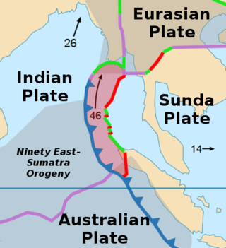
The Burma Plate is a minor tectonic plate or microplate located in Southeast Asia, sometimes considered a part of the larger Eurasian Plate. The Andaman Islands, Nicobar Islands, and northwestern Sumatra are located on the plate. This island arc separates the Andaman Sea from the main Indian Ocean to the west.
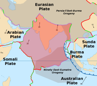
The Indian Plate is a minor tectonic plate straddling the equator in the Eastern Hemisphere. Originally a part of the ancient continent of Gondwana, the Indian Plate broke away from the other fragments of Gondwana 100 million years ago, began moving north and carried Insular India with it. It was once fused with the adjacent Australian Plate to form a single Indo-Australian Plate, and recent studies suggest that India and Australia have been separate plates for at least 3 million years and likely longer. The Indian Plate includes most of modern South Asia and a portion of the basin under the Indian Ocean, including parts of South China and western Indonesia, and extending up to but not including Ladakh, Kohistan and Balochistan.
The Tonga Plate is a small southwest Pacific tectonic plate or microplate. It is centered at approximately 19° S. latitude and 173° E. longitude. The plate is an elongated plate oriented NNE - SSW and is a northward continuation of the Kermadec linear zone north of New Zealand. The plate is bounded on the east and north by the Pacific Plate, on the northwest by the Niuafo’ou Microplate, on the west and south by the Indo-Australian Plate. The Tonga plate is subducting the Pacific plate along the Tonga Trench. This subduction turns into a transform fault boundary north of Tonga. An active rift or spreading center separates the Tonga Plate from the Australian Plate and the Niuafo’ou microplate to the west. The Tonga Plate is seismically very active and is rotating clockwise.

The Indonesian island of Sumatra is located in a highly seismic area of the world. In addition to the subduction zone off the west coast of the island, Sumatra also has a large strike-slip fault, the Great Sumatran Fault also known as Semangko Fault, running the entire length of the island. This fault zone accommodates most of the strike-slip motion associated with the oblique convergence between the Indo-Australian and Eurasian plates. The fault ends in the north just below the city of Banda Aceh, which was devastated in the 2004 Indian Ocean earthquake. After the December 2004 earthquake, pressure on the Great Sumatran Fault has increased tremendously, especially in the north.

The Owen Fracture Zone (OFZ), though misnamed a fracture zone, is a transform fault in the northwest Indian Ocean that separates the Arabian and African Plates from the Indian Plate. Extending north-northeast from where the Carlsberg Ridge meets the Sheba ridge in the south to the Makran Subduction Zone in the north, it represents the port side of the northward motion of the Indian subcontinent during the Late Cretaceous–Palaeogene break-up of Gondwana. Slip along the Owen Fracture Zone is occurring at 2 mm (0.079 in)/yr, the slowest rate on Earth, which means the Arabian Plate moves northward faster than the Indian Plate.
The Aden-Owen-Carlsberg Triple Junction (AOC), also known as the Arabia–India–Somalia Triple Junction, is a triple junction that connects the Aden Ridge, Owen Fracture Zone, and Carlsberg Ridge in the northwest Indian Ocean. It has been described as one of only three RRF (ridge-ridge-fault) triple junctions on Earth, besides the Azores Triple Junction and Chile Triple Junction. However, because the fault arm of such unstable triple junctions tend to evolve into a spreading centre, all three cases have quickly evolved into stable RRR triple junctions.

The Macquarie Triple Junction is a geologically active tectonic boundary located at 61°30′S161°0′E at which the historic Indo-Australian Plate, Pacific Plate, and Antarctic Plate collide and interact. The term Triple Junction is given to particular tectonic boundaries at which three separate tectonic plates meet at a specific, singular location. The Macquarie Triple Junction is located on the seafloor of the southern region of the Pacific Ocean, just south of New Zealand. This tectonic boundary was named in respect to the nearby Macquarie Island, which is located southeast of New Zealand.

The Kermadec-Tonga subduction zone is a convergent plate boundary that stretches from the North Island of New Zealand northward. The formation of the Kermadec and Tonga Plates started about 4–5 million years ago. Today, the eastern boundary of the Tonga Plate is one of the fastest subduction zones, with a rate up to 24 cm/yr. The trench formed between the Kermadec-Tonga and Pacific Plates is also home to the second deepest trench in the world, at about 10,800 m, as well as the longest chain of submerged volcanoes.

The 1,600 kilometres (990 mi) long Macquarie Fault Zone is a major right lateral-moving transform fault along the seafloor of the south Pacific Ocean which runs from New Zealand southwestward towards the Macquarie Triple Junction. It is also the tectonic plate boundary between the Australian Plate to the northwest and the Pacific Plate to the southeast. As such it is a region of high seismic activity and recorded the largest strike-slip event on record up to May 23, 1989, of at least 8.0

Zealandia, also known as Te Riu-a-Māui (Māori) or Tasmantis, is an almost entirely submerged mass of continental crust in Oceania that subsided after breaking away from Gondwana 83–79 million years ago. It has been described variously as a submerged continent, continental fragment, and microcontinent. The name and concept for Zealandia was proposed by Bruce Luyendyk in 1995, and satellite imagery shows it to be almost the size of Australia. A 2021 study suggests Zealandia is 1 billion years old, about twice as old as geologists previously thought.

The Kermadec Plate is a long and narrow tectonic plate located west of the Kermadec Trench in the south Pacific Ocean. Also included on this tectonic plate is a small portion of the North Island of New Zealand and the Kermadec Islands. It is separated from the Australian Plate by a long divergent boundary which forms a back-arc basin. This area is highly prone to earthquakes and tsunamis.
The Madagascar Plate or Madagascar block is a tectonic plate holding the island of Madagascar. It was once attached to the Gondwana supercontinent and later the Indo-Australian Plate.
The 1947 Assam earthquake occurred on 29 July at 13:43 UTC with an of 7.3 and a maximum EMS-98 intensity of V (Strong).
The 2012 Indian Ocean earthquakes were magnitude 8.6 and 8.2 Mw undersea earthquakes that struck near the Indonesian province of Aceh on 11 April at 15:38 local time. Initially, authorities feared that the initial earthquake would cause a tsunami and warnings were issued across the Indian Ocean; however, these warnings were subsequently cancelled. These were unusually strong intraplate earthquakes and the largest strike-slip earthquake ever recorded.
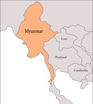
The geology of Myanmar is shaped by dramatic, ongoing tectonic processes controlled by shifting tectonic components as the Indian plate slides northwards and towards Southeast Asia. Myanmar spans across parts of three tectonic plates separated by north-trending faults. To the west, a highly oblique subduction zone separates the offshore Indian plate from the Burma microplate, which underlies most of the country. In the center-east of Myanmar, a right lateral strike slip fault extends from south to north across more than 1,000 km (620 mi). These tectonic zones are responsible for large earthquakes in the region. The India-Eurasia plate collision which initiated in the Eocene provides the last geological pieces of Myanmar, and thus Myanmar preserves a more extensive Cenozoic geological record as compared to records of the Mesozoic and Paleozoic eras. Myanmar is physiographically divided into three regions: the Indo-Burman Range, Myanmar Central Belt and the Shan Plateau; these all display an arcuate shape bulging westwards. The varying regional tectonic settings of Myanmar not only give rise to disparate regional features, but they also foster the formation of petroleum basins and a diverse mix of mineral resources.

Zealandia is an area of mostly submerged continental crust that contains New Zealand and New Caledonia.