
The Ring of Fire is a tectonic belt of volcanoes and earthquakes, about 40,000 km (25,000 mi) long and up to about 500 km (310 mi) wide, which surrounds most of the Pacific Ocean. The exact number of volcanoes within the Ring of Fire is not universally agreed but, depending on which regions are included in any particular count, it contains between 750 and 915 active or dormant volcanoes, around two-thirds of the world total. About 90% of the world's earthquakes, including most of its largest, occur within the belt.

The Juan de Fuca Plate is a small tectonic plate (microplate) generated from the Juan de Fuca Ridge that is subducting beneath the northerly portion of the western side of the North American Plate at the Cascadia subduction zone. It is named after the explorer of the same name. One of the smallest of Earth's tectonic plates, the Juan de Fuca Plate is a remnant part of the once-vast Farallon Plate, which is now largely subducted underneath the North American Plate.

The Gorda Plate, located beneath the Pacific Ocean off the coast of northern California, is one of the northern remnants of the Farallon Plate. It is sometimes referred to as simply the southernmost portion of the neighboring Juan de Fuca Plate, another Farallon remnant.

The Explorer Plate is an oceanic tectonic plate beneath the Pacific Ocean off the west coast of Vancouver Island, Canada, which is partially subducted under the North American Plate. Along with the Juan de Fuca Plate and Gorda Plate, the Explorer Plate is a remnant of the ancient Farallon Plate, which has been subducted under the North American Plate. The Explorer Plate separated from the Juan de Fuca Plate roughly 4 million years ago. In its smoother, southern half, the average depth of the Explorer plate is roughly 2,400 metres (7,900 ft) and rises up in its northern half to a highly variable basin between 1,400 metres (4,600 ft) and 2,200 metres (7,200 ft) in depth.
Kamaʻehuakanaloa Seamount is an active submarine volcano about 22 mi (35 km) off the southeast coast of the island of Hawaii. The top of the seamount is about 3,200 ft (975 m) below sea level. This seamount is on the flank of Mauna Loa, the largest active subaerial shield volcano on Earth. Kamaʻehuakanaloa is the newest volcano in the Hawaiian–Emperor seamount chain, a string of volcanoes that stretches about 3,900 mi (6,200 km) northwest of Kamaʻehuakanaloa. Unlike most active volcanoes in the Pacific Ocean that make up the active plate margins on the Pacific Ring of Fire, Kamaʻehuakanaloa and the other volcanoes of the Hawaiian–Emperor seamount chain are hotspot volcanoes and formed well away from the nearest plate boundary. Volcanoes in the Hawaiian Islands arise from the Hawaii hotspot, and as the youngest volcano in the chain, Kamaʻehuakanaloa is the only Hawaiian volcano in the deep submarine preshield stage of development.

The Garibaldi Volcanic Belt is a northwest–southeast trending volcanic chain in the Pacific Ranges of the Coast Mountains that extends from Watts Point in the south to the Ha-Iltzuk Icefield in the north. This chain of volcanoes is located in southwestern British Columbia, Canada. It forms the northernmost segment of the Cascade Volcanic Arc, which includes Mount St. Helens and Mount Baker. Most volcanoes of the Garibaldi chain are dormant stratovolcanoes and subglacial volcanoes that have been eroded by glacial ice. Less common volcanic landforms include cinder cones, volcanic plugs, lava domes and calderas. These diverse formations were created by different styles of volcanic activity, including Peléan and Plinian eruptions.

The Cascadia subduction zone is a 960 km fault at a convergent plate boundary, about 112-160 km off the Pacific Shore, that stretches from northern Vancouver Island in Canada to Northern California in the United States. It is capable of producing 9.0+ magnitude earthquakes and tsunamis that could reach 30m. The Oregon Department of Emergency Management estimates shaking would last 5-7 minutes along the coast, with strength and intensity decreasing further from the epicenter. It is a very long, sloping subduction zone where the Explorer, Juan de Fuca, and Gorda plates move to the east and slide below the much larger mostly continental North American Plate. The zone varies in width and lies offshore beginning near Cape Mendocino, Northern California, passing through Oregon and Washington, and terminating at about Vancouver Island in British Columbia.
The Gorda Ridge, aka Gorda Ridges tectonic spreading center, is located roughly 200 kilometres (120 mi) off the northern coast of California and southern Oregon. Running NE – SW it is roughly 300 kilometres (190 mi) in length. The ridge is broken into three segments; the northern ridge, central ridge, and the southern ridge, which contains the Escanaba Trough.

Volcanic activity is a major part of the geology of Canada and is characterized by many types of volcanic landform, including lava flows, volcanic plateaus, lava domes, cinder cones, stratovolcanoes, shield volcanoes, submarine volcanoes, calderas, diatremes, and maars, along with less common volcanic forms such as tuyas and subglacial mounds.

The Explorer Ridge is a mid-ocean ridge, a divergent tectonic plate boundary located about 241 km (150 mi) west of Vancouver Island, British Columbia, Canada. It lies at the northern extremity of the Pacific spreading axis. To its east is the Explorer Plate, which together with the Juan de Fuca Plate and the Gorda Plate to its south, is what remains of the once-vast Farallon Plate which has been largely subducted under the North American Plate. The Explorer Ridge consists of one major segment, the Southern Explorer Ridge, and several smaller segments. It runs northward from the Sovanco Fracture Zone to the Queen Charlotte Triple Junction, a point where it meets the Queen Charlotte Fault and the northern Cascadia subduction zone.

The geology of the Pacific Northwest includes the composition, structure, physical properties and the processes that shape the Pacific Northwest region of North America. The region is part of the Ring of Fire: the subduction of the Pacific and Farallon Plates under the North American Plate is responsible for many of the area's scenic features as well as some of its hazards, such as volcanoes, earthquakes, and landslides.
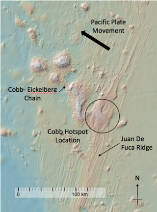
The Cobb hotspot is a marine volcanic hotspot at, which is 460 km (290 mi) west of Oregon and Washington, North America, in the Pacific Ocean. Over geologic time, the Earth's surface has migrated with respect to the hotspot through plate tectonics, creating the Cobb–Eickelberg Seamount chain. The hotspot is currently collocated with the Juan de Fuca Ridge.
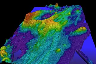
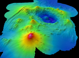
Axial Seamount is a seamount, submarine volcano, and underwater shield volcano in the Pacific Ocean, located on the Juan de Fuca Ridge, approximately 480 km (298 mi) west of Cannon Beach, Oregon. Standing 1,100 m (3,609 ft) high, Axial Seamount is the youngest volcano and current eruptive center of the Cobb–Eickelberg Seamount chain. Located at the center of both a geological hotspot and a mid-ocean ridge, the seamount is geologically complex, and its origins are still poorly understood. Axial Seamount is set on a long, low-lying plateau, with two large rift zones trending 50 km (31 mi) to the northeast and southwest of its center. The volcano features an unusual rectangular caldera, and its flanks are pockmarked by fissures, vents, sheet flows, and pit craters up to 100 m (328 ft) deep; its geology is further complicated by its intersection with several smaller seamounts surrounding it.
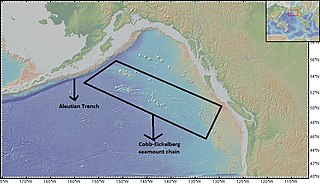
The Cobb-Eickelberg seamount chain is a range of undersea mountains formed by volcanic activity of the Cobb hotspot located in the Pacific Ocean. The seamount chain extends to the southeast on the Pacific Plate, beginning at the Aleutian Trench and terminating at Axial Seamount, located on the Juan de Fuca Ridge. The seamount chain is spread over a vast length of approximately 1,800 km. The location of the Cobb hotspot that gives rise to these seamounts is 46° N—130° W. The Pacific plate is moving to the northwest over the hotspot, causing the seamounts in the chain to decrease in age to the southeast. Axial is the youngest seamount and is located approximately 480 km west of Cannon Beach, Oregon. The most studied seamounts that make up this chain are Axial, Brown Bear, Cobb, and Patton seamounts. There are many other seamounts in this chain which have not been explored.

The Endeavour Hydrothermal Vents are a group of hydrothermal vents in the north-eastern Pacific Ocean, located 260 kilometres (160 mi) southwest of Vancouver Island, British Columbia, Canada. The vent field lies 2,250 metres (7,380 ft) below sea level on the northern Endeavour segment of the Juan de Fuca Ridge. In 1982, dredged sulfide samples were recovered from the area covered in small tube worms and prompted a return to the vent field in August 1984, where the active vent field was confirmed by HOV Alvin on leg 10 of cruise AII-112.

West Mata is an active submarine volcano located in the northeastern Lau Basin, roughly 200 km (124 mi) southwest of the Samoan Islands. It is part of the Tonga-Kermadec volcanic arc, which stretches from the North Island of New Zealand to Samoa. The volcano was first discovered in 2008 by scientists aboard the R/V Thompson research vessel, using sonar mapping and a remotely operated vehicle (ROV) to explore the seafloor. At the same time West Mata was discovered, multiple neighboring volcanoes—most of them hydrothermally active—were discovered as well, including Volcano O, Tafu-Maka, Northern Matas and East Mata.

The Canadian Cascade Arc, also called the Canadian Cascades, is the Canadian segment of the North American Cascade Volcanic Arc. Located entirely within the Canadian province of British Columbia, it extends from the Cascade Mountains in the south to the Coast Mountains in the north. Specifically, the southern end of the Canadian Cascades begin at the Canada–United States border. However, the specific boundaries of the northern end are not precisely known and the geology in this part of the volcanic arc is poorly understood. It is widely accepted by geologists that the Canadian Cascade Arc extends through the Pacific Ranges of the Coast Mountains. However, others have expressed concern that the volcanic arc possibly extends further north into the Kitimat Ranges, another subdivision of the Coast Mountains, and even as far north as Haida Gwaii.

The Pacific Ocean evolved in the Mesozoic from the Panthalassic Ocean, which had formed when Rodinia rifted apart around 750 Ma. The first ocean floor which is part of the current Pacific Plate began 160 Ma to the west of the central Pacific and subsequently developed into the largest oceanic plate on Earth.
Ocean Networks Canada is a world-leading research and ocean observing facility hosted and owned by the University of Victoria, and managed by the not-for profit ONC Society. ONC operates unparalleled observatories in the deep ocean and coastal waters of Canada’s three coasts–the Arctic, the Pacific and the Atlantic–gathering biological, chemical, geological and physical data to drive solutions for science, industry and society. ONC operates the NEPTUNE and VENUS cabled ocean observatories in the northeast Pacific Ocean and the Salish Sea. Additionally, Ocean Networks Canada operates smaller community-based observatories offshore from Cambridge Bay, Nunavut., Campbell River, Kitamaat Village and Digby Island. These observatories collect data on physical, chemical, biological, and geological aspects of the ocean over long time periods. As with other ocean observatories such as ESONET, Ocean Observatories Initiative, MACHO and DONET, scientific instruments connected to Ocean Networks Canada are operated remotely and provide continuous streams of freely available data to researchers and the public. Over 200 gigabytes of data are collected every day.
Monowai Seamount is a volcanic seamount to the north of New Zealand. It is formed by a large caldera and a volcanic cone just south-southeast from the caldera. The volcanic cone rises to depths of up to 100 metres (330 ft) but its depth varies with ongoing volcanic activity, including sector collapses and the growth of lava domes. The seamount and its volcanism were discovered after 1877, but only in 1980 was it named "Monowai" after a research ship of the same name.


