Fort Branch, Indiana

Last updated

Fort Branch, Indiana
Town of Fort Branch
Fort Branch, Indiana.jpg
Gibson County Indiana Incorporated and Unincorporated areas Fort Branch Highlighted 1824250.svg
Location of Fort Branch in Gibson County, Indiana.
Coordinates: 38°14′49″N87°34′24″W / 38.24694°N 87.57333°W / 38.24694; -87.57333
Country United States
State Indiana
County Gibson
Township Union
Area
[1]
  Total1.10 sq mi (2.85 km2)
  Land1.09 sq mi (2.82 km2)
  Water0.01 sq mi (0.03 km2)
Elevation
[2]
456 ft (139 m)
Population
 (2020)
  Total2,965
  Density2,725.18/sq mi (1,052.14/km2)
Time zone UTC-6 (CST)
  Summer (DST) UTC-5 (CDT)
ZIP code
47648
Area code(s) 812, 930
FIPS code 18-24250 [3]
GNIS feature ID2396941 [2]
U.S. Highways US 41.svg
Major State Roads Indiana 168.svg

Fort Branch is the largest town and 2nd largest community in Gibson County, Indiana after Princeton. The population was 2,965 at the 2020 census. It is part of the Evansville, Indiana, Metropolitan Area.

Contents

History

Fort Branch had its start in the year 1852 by the building of the railroad through that territory. [4] The town was originally called LaGrange, for the original owner of the site, but as there was another post office of that same name in Indiana, the town was renamed in commemoration of an old fort. [5]

Former Emge Foods Processing plant along the town's west side Former Emge Plant from west.jpg
Former Emge Foods Processing plant along the town's west side

On April 3, 1989, an F3 tornado passed through the town causing between 5 and 50 million dollars in damage. [6]

On February 28, 2017, an EF3 wedge tornado, originating in Crossville, Illinois, passed to the north of the town, destroying or heavily damaging several structures along Indiana 168. [7]

Geography

Fort Branch is located at 38°14′49″N87°34′34″W / 38.24694°N 87.57611°W / 38.24694; -87.57611 (38.246872, -87.576003). [8]

According to the 2010 census, Fort Branch has a total area of 1.11 square miles (2.87 km2), of which 1.1 square miles (2.85 km2) (or 99.1%) is land and 0.01 square miles (0.03 km2) (or 0.9%) is water. [9]

Demographics

Historical population
CensusPop.Note
1880 778
1890 748−3.9%
1900 84913.5%
1910 1,18239.2%
1920 1,38917.5%
1930 1,341−3.5%
1940 1,55215.7%
1950 1,94425.3%
1960 1,9832.0%
1970 2,53527.8%
1980 2,504−1.2%
1990 2,447−2.3%
2000 2,320−5.2%
2010 2,77119.4%
2020 2,9657.0%
U.S. Decennial Census [10]

2010 census

As of the census [11] of 2010, there were 2,771 people, 1,162 households, and 774 families living in the town. The population density was 2,519.1 inhabitants per square mile (972.6/km2). There were 1,244 housing units at an average density of 1,130.9 per square mile (436.6/km2). The racial makeup of the town was 96.8% White, 0.3% African American, 0.1% Native American, 1.2% Asian, 0.6% from other races, and 0.9% from two or more races. Hispanic or Latino of any race were 0.9% of the population.

There were 1,162 households, of which 31.7% had children under the age of 18 living with them, 51.3% were married couples living together, 10.8% had a female householder with no husband present, 4.6% had a male householder with no wife present, and 33.4% were non-families. 29.3% of all households were made up of individuals, and 10.7% had someone living alone who was 65 years of age or older. The average household size was 2.38 and the average family size was 2.93.

The median age in the town was 38 years. 24.4% of residents were under the age of 18; 8.2% were between the ages of 18 and 24; 26.2% were from 25 to 44; 26.9% were from 45 to 64; and 14.4% were 65 years of age or older. The gender makeup of the town was 49.8% male and 50.2% female.

2000 census

As of the census [3] of 2000, there were 2,320 people, 985 households, and 647 families living in the town. The population density was 3,131.0 inhabitants per square mile (1,208.9/km2). There were 1,051 housing units at an average density of 1,418.4 per square mile (547.6/km2). The racial makeup of the town was 98.53% White, 0.26% African American, 0.26% Native American, 0.26% Asian, 0.30% from other races, and 0.39% from two or more races. Hispanic or Latino of any race were 0.69% of the population.

There were 985 households, out of which 31.2% had children under the age of 18 living with them, 54.2% were married couples living together, 8.3% had a female householder with no husband present, and 34.3% were non-families. 30.4% of all households were made up of individuals, and 13.7% had someone living alone who was 65 years of age or older. The average household size was 2.35 and the average family size was 2.95.

In the town, the population was spread out, with 24.5% under the age of 18, 8.3% from 18 to 24, 30.5% from 25 to 44, 20.3% from 45 to 64, and 16.4% who were 65 years of age or older. The median age was 37 years. For every 100 females, there were 92.4 males. For every 100 females age 18 and over, there were 92.1 males.

The median income for a household in the town was $35,964, and the median income for a family was $46,397. Males had a median income of $34,125 versus $21,314 for females. The per capita income for the town was $17,180. About 1.6% of families and 4.4% of the population were below the poverty line, including 3.1% of those under age 18 and 3.2% of those age 65 or over.

Education

South Gibson School Corporation

K-8: Fort Branch Community School

9-12: Gibson Southern High School

College: Vincennes University Center for Advanced Manufacturing

Former Schools

Fort Branch High School (merged into Gibson Southern High School in 1974)

Marlette School

Public library

Fort Branch has a public library, a branch of the Fort Branch-Johnson Township Public Library system. [12]

Economy

Like Princeton, Fort Branch is also largely a blue-collar town although of somewhat smaller size. For a long time the town's largest employer was the Emge Foods processing and packing plant, still located along the southwest portion of the town. When the plant closed in May 1999, it had been in operation for nearly 90 years.

As the Emge plant was starting to close, Toyota announced that it would be building a manufacturing facility on a patch of farmland located halfway between Fort Branch and nearby Princeton. While most of the suppliers for the new Toyota plant are located closer to Princeton, most of the population gains from employees moving closer to work moved into either Fort Branch, or into Haubstadt or Owensville.

Indiana 168 between Owensville and Fort Branch. The Emge plant is visible in the distance as it looked in 2007. In-168.JPG
Indiana 168 between Owensville and Fort Branch. The Emge plant is visible in the distance as it looked in 2007.

Recently, Vincennes University announced plans to build an advanced manufacturing education facility just south of Fort Branch along U.S. 41 to provide such education to an area becoming more diverse in manufacturing methods. This is expected to provide a major boost to lifestyle in the Fort Branch-Haubstadt Area. Ground Broke on the new facility on October 23, 2009. The facility opened in August 2011.

On June 18, 2010, a fire started at the former Emge Foods plant. By June 22, the fire had destroyed the vacant meat processing plant portion of the complex but was put out. Fire departments from three counties battled to control the fire, dealing with the unstable structure of the 100+-year-old building and the 95+-degree temperatures that occurred during the five-day period the fire burned. [13] As of February 2014, only the smokestack remains of the plant, with the remains being demolished along with the original water tower between September 2013 and January 2014. As of December 2014, there are no known plans for the future of the property.

Notable person

Sheriff Thomas Beloat, noted for his bravery in stopping a lynching in Gibson County, mentioned in an essay by Mark Twain, The United States of Lyncherdom .

Panorama

Fort Branch from west panorama.jpg
Panorama of Fort Branch from County Road 225W.

Highways

Related Research Articles

<span class="mw-page-title-main">Gibson County, Indiana</span> County in Indiana, United States

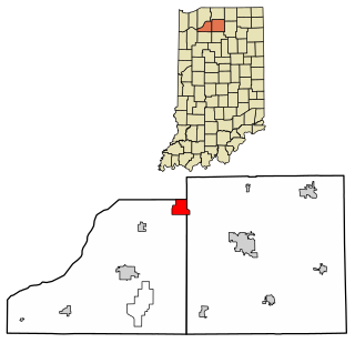
Gibson County is a county in the southwestern part of the U.S. state of Indiana. As of the 2020 United States Census, the population was 33,011. The county seat is Princeton.

<span class="mw-page-title-main">Edinburgh, Indiana</span> City in Indiana, United States

Edinburgh is a town in Johnson, Bartholomew, and Shelby counties in the U.S. state of Indiana. The population was 4,480 at the 2010 census. It is part of the Columbus, Indiana metropolitan statistical area. Edinburgh was named in honor of Edinburgh, Scotland and for many years was pronounced the same way.

<span class="mw-page-title-main">Ulen, Indiana</span> Town in Indiana, United States

Ulen is a town in Center Township, Boone County, in the U.S. state of Indiana. The population was 117 at the 2010 census. The town is surrounded by the city of Lebanon.

<span class="mw-page-title-main">Albany, Indiana</span> Town in Indiana, United States

Albany is a town in Delaware and Randolph counties in the U.S. state of Indiana, along the Mississinewa River. The population was 2,295 at the 2020 census. It is part of the Muncie, IN Metropolitan Statistical Area.

<span class="mw-page-title-main">Chesterfield, Indiana</span> Town in Indiana, United States

Chesterfield is a town in the U.S. state of Indiana which lies in Union Township, Madison County, and Salem Township, Delaware County. The population was 2,490 at the 2020 census. It is part of the Indianapolis–Carmel–Anderson metropolitan statistical area.

<span class="mw-page-title-main">Laurel, Indiana</span> Town in Indiana, United States

Laurel is a town in Laurel Township, Franklin County, Indiana, United States. The population was 512 at the 2010 census.

<span class="mw-page-title-main">Haubstadt, Indiana</span> Town in Indiana, United States

Haubstadt is the second largest town, after Fort Branch, and fourth largest community in Gibson County, Indiana, United States. The population was 1,638 at the 2020 census. Haubstadt has recently become a bedroom community of Evansville and such, is part of the Evansville, Indiana, Metropolitan Area.

<span class="mw-page-title-main">Hazleton, Indiana</span> Town in Indiana, United States

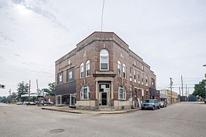
Hazleton is a town in White River Township, Gibson County, Indiana, United States. The population was 263 at the 2010 census making it the second smallest community in the county. While having almost no connection to it, it is part of the Evansville, Indiana, Metropolitan Area.

<span class="mw-page-title-main">Owensville, Indiana</span> Town in Indiana, United States

Owensville is the third largest town and the smallest of the five larger communities in Gibson County, Indiana, United States. The population was 1,338 in 2020.

<span class="mw-page-title-main">Princeton, Indiana</span> City in Indiana, United States

Princeton is the largest city in and the county seat of Patoka Township, Gibson County, Indiana, United States. The population was 8,301 at the 2020 United States Census, and it is part of the greater Evansville, Indiana, Metropolitan Area.

<span class="mw-page-title-main">Upland, Indiana</span> Town in Indiana, United States

Upland is a town in Jefferson Township, Grant County, Indiana, United States. The population was 3,821 at the 2020 census. It is the home of Taylor University, a Christian college.

<span class="mw-page-title-main">Medora, Indiana</span> Town in Indiana, United States

Medora is a town in Carr Township, Jackson County, Indiana, United States. The population was 693 at the 2010 census.

<span class="mw-page-title-main">New Whiteland, Indiana</span> Town in Indiana, United States

New Whiteland is a town in Pleasant Township, Johnson County, Indiana, United States. The population was 5,550 at the 2020 census.

<span class="mw-page-title-main">Summitville, Indiana</span> Town in Indiana, United States

Summitville is a town in Van Buren Township, Madison County, Indiana, United States. It is part of the Indianapolis–Carmel–Anderson metropolitan statistical area. The population was 989 at the 2020 census.

<span class="mw-page-title-main">Woodlawn Heights, Indiana</span> Town in Indiana, United States

Woodlawn Heights is a town in Anderson Township, Madison County, Indiana, United States. It is part of the Indianapolis–Carmel–Anderson metropolitan statistical area. The population was 91 at the 2020 census.

<span class="mw-page-title-main">Koontz Lake, Indiana</span> Census-designated place in Indiana, United States

Koontz Lake is an unincorporated community and census-designated place in Starke and Marshall counties in Indiana. The population was 1,667 at the 2020 census.

<span class="mw-page-title-main">Napoleon, Indiana</span> Town in Indiana, United States

Napoleon is a town in Jackson Township, Ripley County, in the U.S. state of Indiana. The population was 234 at the 2010 census.

<span class="mw-page-title-main">Walkerton, Indiana</span> Town in Indiana, United States

Walkerton is a town in Lincoln Township, St. Joseph County, in the U.S. state of Indiana. The population was 2,144 at the 2010 Census. It is part of the South Bend–Mishawaka, IN-MI, Metropolitan Statistical Area.

<span class="mw-page-title-main">Tennyson, Indiana</span> Town in Indiana, United States

Tennyson is a town in Skelton Township, Warrick County, in the U.S. state of Indiana. The population was 279 at the 2010 census.

<span class="mw-page-title-main">Van Wert, Ohio</span> City in Ohio, United States

Van Wert is a city in and the county seat of Van Wert County, Ohio, United States. It is located in northwestern Ohio approximately 77 miles (124 km) southwest of Toledo and 34 miles (55 km) southeast of Fort Wayne, Indiana. The population was 11,092 at the 2020 census. It is the principal city of the Van Wert micropolitan area, which is included in the Lima–Van Wert–Wapakoneta combined statistical area.

References

  1. "2020 U.S. Gazetteer Files". United States Census Bureau. Retrieved March 16, 2022.
  2. 1 2 U.S. Geological Survey Geographic Names Information System: Fort Branch, Indiana
  3. 1 2 "U.S. Census website". United States Census Bureau . Retrieved January 31, 2008.
  4. Peattie, Elia Wilkinson (1897). History of Gibson County, Indiana. Cook & McDowell Publications. p. 13.
  5. Stormont, Gil R. (1914). History of Gibson County, Indiana: Her People, Industries and Institutions. B.F. Bowen. pp.  353.
  6. "Tornado History Project: 19890403.18.5". Archived from the original on July 7, 2017. Retrieved May 23, 2017.
  7. "Family, friends come together to help after tornado in Gibson County".
  8. "US Gazetteer files: 2010, 2000, and 1990". United States Census Bureau. February 12, 2011. Retrieved April 23, 2011.
  9. "G001 - Geographic Identifiers - 2010 Census Summary File 1". United States Census Bureau. Archived from the original on February 13, 2020. Retrieved July 16, 2015.
  10. "Census of Population and Housing". Census.gov. Retrieved June 4, 2015.
  11. "U.S. Census website". United States Census Bureau . Retrieved December 11, 2012.
  12. "Indiana public library directory" (PDF). Indiana State Library. Archived from the original (PDF) on February 18, 2017. Retrieved March 7, 2018.
  13. Wilson, Mark. "Crews attempt to reach 'hot spots' at Emge plant fire » Evansville Courier & Press". Courierpress.com. Retrieved January 23, 2013.