Franklin, Milwaukee County, Wisconsin

Last updated

Franklin, Wisconsin
Milwaukee County Wisconsin Incorporated and Unincorporated areas Franklin Highlighted.svg
Location of Franklin in Milwaukee County, Wisconsin.
Coordinates: 42°53′57″N88°0′8″W / 42.89917°N 88.00222°W / 42.89917; -88.00222
County Milwaukee
Founded1841
Incorporated 1956
Government
   Mayor John Nelson
Area
[1]
  Total34.68 sq mi (89.82 km2)
  Land34.58 sq mi (89.55 km2)
  Water0.10 sq mi (0.27 km2)
Elevation
790 ft (241 m)
Population
 (2020) [2]
  Total36,816
  Estimate 
(2021) [3]
36,624
  Density1,035.75/sq mi (399.91/km2)
Time zone UTC−6 (Central)
  Summer (DST) UTC−5 (Central)
ZIP Code
53132
Area code 414
FIPS code 55-27300
GNIS feature ID1583234
Website www.franklinwi.gov

Franklin is a city in Milwaukee County, Wisconsin, United States. It is a suburb of Milwaukee with a population of 36,816 as of the 2020 census.

Contents

History

On December 20, 1839, the south portion of the Town of Kinnikinick was split off to form the town of Franklin. The town consisted of a 36-square-mile area that was originally covered with heavy timber, which was mostly hardwoods such as hickory, walnut, and butternut. Most of the town's drainage was delivered by the Root River and there was an abundance of wildlife including bears, deer, and wolves. [4] As of the 1840 census, the population of the Town of Franklin was 248. [5] The name "Franklin" was given in homage to Benjamin Franklin.

By the 1950s, Franklin was known as a "City of Homes" for its growing residential areas, which served as a suburb of the city of Milwaukee. In 1956, town officials were concerned by the possibility that the city of Milwaukee might attempt to annex portions of Franklin. In response, the town was incorporated as a fourth-class city on August 15, 1956.

Geography

Franklin is located at 42°53′57″N88°00′08″W / 42.899166°N 88.002204°W / 42.899166; -88.002204 (42.899166, 88.002204). [6] It is bounded by the city of Oak Creek to the east, the villages of Greendale and Hales Corners and the city of Greenfield to the north, the county of Racine to the south, and the county of Waukesha to the west. [7]

According to the United States Census Bureau, the city has a total area of 34.69 square miles (89.85 km2), of which, 34.58 square miles (89.56 km2) is land and 0.11 square miles (0.28 km2) is water. [8]

The Root River runs south through Franklin, bisecting the city.

Root River Valley Root River Valley.JPG
Root River Valley

Climate

Franklin
Climate chart (explanation)
J
F
M
A
M
J
J
A
S
O
N
D
 
 
97
 
 
−6
−12
 
 
101
 
 
−3
−11
 
 
68
 
 
6
−6
 
 
165
 
 
17
2
 
 
111
 
 
20
5
 
 
138
 
 
29
12
 
 
100
 
 
28
16
 
 
95
 
 
26
13
 
 
67
 
 
23
11
 
 
92
 
 
15
6
 
 
64
 
 
7
−2
 
 
78
 
 
−3
−8
Average max. and min. temperatures in °C
Precipitation totals in mm
Source: [9]
Imperial conversion
JFMAMJJASOND
 
 
3.8
 
 
21
10
 
 
4
 
 
27
12
 
 
2.7
 
 
43
21
 
 
6.5
 
 
63
36
 
 
4.4
 
 
68
41
 
 
5.4
 
 
84
54
 
 
3.9
 
 
82
61
 
 
3.7
 
 
79
55
 
 
2.6
 
 
73
52
 
 
3.6
 
 
59
43
 
 
2.5
 
 
45
28
 
 
3.1
 
 
27
18
Average max. and min. temperatures in °F
Precipitation totals in inches

Demographics

Historical population
CensusPop.Note
1960 10,006
1970 12,24722.4%
1980 16,87137.8%
1990 21,85529.5%
2000 29,49435.0%
2010 35,45120.2%
2020 36,8163.9%
2021 (est.)36,624 [3] −0.5%
U.S. Decennial Census [10]

2010 census

As of the census [2] of 2010, there were 35,451 people, 13,642 households, and 9,351 families living in the city. The population density was 1,025.2 inhabitants per square mile (395.8/km2). There were 14,356 housing units at an average density of 415.2 per square mile (160.3/km2). The racial makeup of the city was 87.1% White, 4.9% African American, 0.4% Native American, 5.4% Asian, 0.8% from other races, and 1.5% from two or more races. Hispanic or Latino of any race were 4.5% of the population. The House of Correction members are counted in this demographic.

There were 13,642 households, of which 30.5% had children under the age of 18 living with them, 58.3% were married couples living together, 6.8% had a female householder with no husband present, 3.5% had a male householder with no wife present, and 31.5% were non-families. 26.4% of all households were made up of individuals, and 10.7% had someone living alone who was 65 years of age or older. The average household size was 2.45 and the average family size was 2.99.

The median age in the city was 41.5 years. 21.6% of residents were under the age of 18; 7.7% were between the ages of 18 and 24; 25.9% were from 25 to 44; 31.4% were from 45 to 64; and 13.4% were 65 years of age or older. The gender makeup of the city was 51.1% male and 48.9% female.

2000 census

As of the census [11] of 2000, there were 29,494 people, 10,602 households, and 7,697 families living in the city. The population density was 851.8 people per square mile (328.8/km2). There were 10,936 housing units at an average density of 315.8 per square mile (121.9/km2). The racial makeup of the city was 98.78% White, 0.15% African American, 0.036% Native American, 2.10% Asian, 0.03% Pacific Islander, 0.67% from other races, and 0.91% from two or more races. Hispanic or Latino of any race were 2.64% of the population.

There were 10,602 households, out of which 33.8% had children under the age of 18 living with them, 63.2% were married couples living together, 6.6% had a female householder with no husband present, and 27.4% were non-families. 22.5% of all households were made up of individuals, and 6.9% had someone living alone who was 65 years of age or older. The average household size was 2.58, and the average family size was 3.06.

In the city, the population was spread out, with 23.4% under the age of 18, 8.4% from 18 to 24, 32.7% from 25 to 44, 25.6% from 45 to 64, and 9.9% who were 65 years of age or older. The median age was 38 years. For every 100 females, there were 109.2 males. For every 100 females age 18 and over, there were 110.0 males.

The median income for a household in the city was US$75,315, and the median income for a family was $95,532. Males had a median income of $61,827 versus $54,737 for females. The per capita income for the city was $33,474. About 0.4% of families and 0.7% of the population were below the poverty line, including 2.7% of those under age 18 and 3.9% of those age 65 or over.

Government

Franklin City Hall Franklin Wisconsin City Hall.JPG
Franklin City Hall

Franklin government consists of a mayor (executive branch), a common council (legislative branch), and a municipal judge (judicial branch). The Common Council's primary purpose is the passage of laws, ordinances and policies, establishment of pay ranges for city employees and management of the city's financial affairs; its budget, its revenues, and the raising of funds for the operation of the city. The Common Council is composed of the mayor and six members representing the six aldermanic districts, serving three-year overlapping terms. One alderman is elected and serves as common council president. [12]

Franklin Police and Municipal Court Franklin Wisconsin Law Enforcement Center.JPG
Franklin Police and Municipal Court

The mayor of the city, elected for a three-year term of office, is the chief executive officer of the city. The mayor is responsible for ensuring that city ordinances and state laws are observed and enforced, and that city officers, boards and commissions properly discharge their duties. The mayor oversees the police and fire departments; nominates the appointment of certain city employees, board and commission members to the council; and is chairman of the Plan Commission and the Community Development Authority. The mayor presides at meetings of the Common Council, voting only in cases if tie votes. City ordinances designate eight cabinet officers, as well as other unclassified positions within city government, that are appointed by the mayor subject to the confirmation by a majority of all members of the common council. [13] Mayor Steve Olson was re-elected in April, 2020 for a third three-year term. [14] In April, 2023, Franklin Alderman John Nelson was elected mayor for his first three-year term as mayor. [15]

County

Franklin is in Milwaukee County. It shares parts of the 9th, 11th and 17th Milwaukee County Supervisor districts, which are the only three districts that fall within the city. [16]

State

Most of Franklin lies in the 28th State Senate District and the 82nd State Assembly District, the remainder lies in the 7th State Senate District and the 21st State Assembly District.

Federal

Franklin is represented in the United States Senate by Senators Ron Johnson (R) and Tammy Baldwin (D). The city falls within Wisconsin's 1st congressional district, which is represented by Bryan Steil (R).

Transportation

Franklin is four miles (6 km) from Milwaukee Mitchell International Airport and close to Interstate 94. Running through the city are U.S. Highway 45, and WIS 36, WIS 100, and WIS 241.

Education

Public

The majority of Franklin primary and secondary students attend schools in the Franklin Public School District, which was formed in 1962 as a K–12 common school district. Franklin has five elementary schools, one middle school and one high school. The Franklin Recreation Department is also operated by the school district. The district is governed by an annual meeting of electors and a seven-member school board elected every three years with overlapping terms and election held every year in April. City government exercises no fiscal control over the school district.

The Oak Creek-Franklin School District serves residents of the far eastern side of Franklin, along 27th street. The district also serves all of the city of Oak Creek.

The Whitnall School District, which serves primarily the neighboring village of Hales Corners and parts of the city of Greenfield, serves Franklin residents residing on the city's far northwest side.

Private

Franklin's private schools include:

Economy

Top employers

According to Franklin's 2012 Comprehensive Annual Financial Report, [17] the top employers in the city were:

#Employer# of Employees
1 Northwestern Mutual 2,550
2 Wheaton Franciscan Healthcare 712
3Franklin Public School District543
4 Krones 450
5 GA Precision 364
6 Milwaukee County Corrections South360
7 Walmart 357
8 Carlisle Interconnect Technologies 270
9Central Aquatics261
10Strauss Brands250

Environmental concerns

Fadrowski Drum Disposal EPA Superfund Site with Dental Associates facility in background SuperfundFadrowskiDrumDisposal20120104.jpg
Fadrowski Drum Disposal EPA Superfund Site with Dental Associates facility in background

Franklin is home to one of the Environmental Protection Agency's Superfund sites. Referred to as the "Fadrowski Drum Disposal Site", [18] or FDDS, the 40-acre (160,000 m2) site located at 42°55′14″N87°57′10″W / 42.920587°N 87.9528584°W / 42.920587; -87.9528584 6865 South 27th Street was found to be contaminated with high amounts of lead and chromium. Trace amounts of arsenic and DDT were also found. [19] The site also contains levels of mercury above Wisconsin enforcement standards. [20] The site once included a human-made pond with elevated cyanide levels. The site was placed on the National Priorities List in 1986, with remedial action (RA) completed in 1994. The site was deleted from the National Priorities List in 2003. [21] The site remedies included restricting access to the site, restricting use of land at the site, limited excavation of the waste (some drums), removal of hazardous soil, monitoring ground water, monitoring surface water, and installing a landfill cap. [22] The site has been largely remediated via landfill and limited excavation, however waste material above health-based levels was left on site. [23]

The site is currently under a monitoring status, with the U.S. Environmental Protection Agency reviewing the site every five years. [24] The site is now encircled by development. It is bordered on the north by a Hobby Lobby, a tributary that flows into the Root River, and South 27th Street. The southern boundary of the site is lined with a Goodwill Industries retail store. Residential properties are just 1,000 feet (300 m) west of the site and 600 feet (180 m) to the south. A Walmart is just 600 feet (180 m) north of the site. The site itself is prohibited from ever being used for potable water, residential development, or any development that would disturb the landfill cap. As of March 2021, a portion of the site is being considered for development as a dog park. [25]

Rankings

In July 2007, CNN/Money and Money magazine ranked Franklin the 90th best place to live in the United States. [26]

Notable people

Related Research Articles

<span class="mw-page-title-main">Milwaukee County, Wisconsin</span> County in Wisconsin, United States

Milwaukee County is located in the U.S. state of Wisconsin. At the 2020 census, the population was 939,489, down from 947,735 in 2010. It is both the most populous and most densely populated county in Wisconsin, and the 45th most populous county nationwide; Milwaukee, its eponymous county seat, is also the most populous city in the state. The county was created in 1834 as part of Michigan Territory and organized the following year.

<span class="mw-page-title-main">De Pere, Wisconsin</span> City in Wisconsin, United States

De Pere is a city in Brown County, Wisconsin, United States. The population was 25,410 at the 2020 census. De Pere is part of the Green Bay Metropolitan Statistical Area.

<span class="mw-page-title-main">Fitchburg, Wisconsin</span> City in Wisconsin, United States

Fitchburg is a city in Dane County, Wisconsin, United States. The population was 29,609 at the 2020 census. Fitchburg is a suburb of Madison and is part of the Madison Metropolitan Statistical Area. Fitchburg consists of a mix of suburban neighborhoods closer to the border with the city of Madison, commercial and industrial properties, and more rural properties in the southern portion of the city.

<span class="mw-page-title-main">Juneau, Wisconsin</span> City in Wisconsin, United States

Juneau is a city in Dodge County, Wisconsin, United States. The population was 2,658 at the 2020 census. It is the county seat of Dodge County.

<span class="mw-page-title-main">Cudahy, Wisconsin</span> City in Wisconsin, United States

Cudahy is a city in Milwaukee County, Wisconsin, United States. The population was 18,204 at the 2020 census.

<span class="mw-page-title-main">Glendale, Wisconsin</span> City in Milwaukee County, Wisconsin

Glendale is a city in Milwaukee County, Wisconsin, United States. It is a suburb of the neighboring Milwaukee. The population was 13,357 at the 2020 census.

<span class="mw-page-title-main">Hales Corners, Wisconsin</span> Village in Wisconsin, United States

Hales Corners is a village in Milwaukee County, Wisconsin, United States. The population was 7,720 at the 2020 census.

<span class="mw-page-title-main">Oak Creek, Wisconsin</span> City in Wisconsin, United States

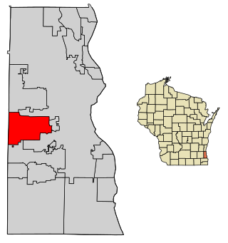
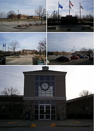
Oak Creek is a city in the U.S. state of Wisconsin. Located in Milwaukee County, it sits on the southwestern shore of Lake Michigan and is located immediately south of Milwaukee. The city is one of the fastest growing in Milwaukee County and all of Wisconsin. As of March 2024, the population is 36,497.

<span class="mw-page-title-main">St. Francis, Wisconsin</span> City in Wisconsin, United States

St. Francis is a city in Milwaukee County, Wisconsin, United States. The population was 9,161 at the 2020 census.

<span class="mw-page-title-main">West Allis, Wisconsin</span> City in Wisconsin, United States

West Allis is a city in Milwaukee County, Wisconsin, United States. A suburb of Milwaukee, it is part of the Milwaukee metropolitan area. The population was 60,325 at the 2020 census, making it the 11th most populous city in Wisconsin.

<span class="mw-page-title-main">Galesville, Wisconsin</span> City in Wisconsin, United States

Galesville is a city in Trempealeau County, Wisconsin, United States. The population was 1,662 at the 2020 census. A dam on Beaver Creek is located at Galesville, forming Lake Marinuka north of the city. The mayor is Vince Howe.

<span class="mw-page-title-main">Lannon, Wisconsin</span> Village in Wisconsin, United States

Lannon is a village in Waukesha County, Wisconsin, United States. The population was 1,355 at the 2020 census. Lannon is a part of the Milwaukee metropolitan area.

<span class="mw-page-title-main">New Berlin, Wisconsin</span> City in Wisconsin

New Berlin is a city located in eastern Waukesha County in the U.S. state of Wisconsin. The population was 40,451 at the 2020 census, making it the third-largest community in Waukesha County after the cities of Waukesha and Brookfield.

<span class="mw-page-title-main">Waupun, Wisconsin</span> City in Wisconsin, United States

Waupun is a city in Dodge and Fond du Lac counties in the U.S. state of Wisconsin. The population was 11,344 at the 2020 census. Of this, 7,795 were in Dodge County, and 3,549 were in Fond du Lac County. In Fond du Lac County, the Town of Waupun abuts the city of Waupun.

<span class="mw-page-title-main">Columbus, Wisconsin</span> City in Wisconsin, United States

Columbus is a city in Columbia County, Wisconsin (mostly) and Dodge County, Wisconsin Counties in the south-central part of the U.S. state of Wisconsin. The population was 5,540 at the 2020 census. All of this population resided in the Columbia County portion of the city. Columbus is located about 28 miles (45 km) northeast of Madison on the Crawfish River. The Columbia County portion of the city lies within the Madison Metropolitan Statistical Area while the Dodge County portion is a part of the Milwaukee-Waukesha-Racine CSA. Nearly all of the city is located within the town of Columbus in Columbia County, though a small portion lies within the town of Elba in Dodge County.

<span class="mw-page-title-main">Mosinee, Wisconsin</span> City in Wisconsin, United States

Mosinee is a city in Marathon County, Wisconsin. It is part of the Wausau, Wisconsin Metropolitan Statistical Area. The population was 4,452 at the time of the 2020 census.

<span class="mw-page-title-main">Fredonia, Wisconsin</span> Village in Ozaukee County, Wisconsin

Fredonia is a village in Ozaukee County, Wisconsin, United States. Located on the Milwaukee River, the village is in the Milwaukee metropolitan area. The population was 2,160 at the 2010 census.

<span class="mw-page-title-main">Durand, Wisconsin</span> City in Wisconsin, United States

Durand is a city in and the county seat of Pepin County, Wisconsin, United States. Situated on the banks of the Chippewa River approximately 15 miles (24 km) from its confluence with the Mississippi River, the city borders the Town of Durand. The population was 1,854 at the 2020 census.

<span class="mw-page-title-main">Brookfield, Wisconsin</span> City in Waukesha County, Wisconsin, U.S.

Brookfield is a city located in Waukesha County, Wisconsin, United States in the Milwaukee metropolitan area. Brookfield had a population of 41,464 at the 2020 census. Brookfield is the third-largest city in Waukesha County. The city is adjacent to the Town of Brookfield.

<span class="mw-page-title-main">Antigo, Wisconsin</span> City in Wisconsin, United States

Antigo is a city in and the county seat of Langlade County, Wisconsin, United States. The population was 8,100 at the 2020 census. Antigo is the center of a farming and lumbering district, and its manufactures consist principally of lumber, chairs, furniture, sashes, doors and blinds, hubs and spokes, and other wood products.

References

  1. "2019 U.S. Gazetteer Files". United States Census Bureau. Retrieved August 7, 2020.
  2. 1 2 "U.S. Census website". United States Census Bureau . Retrieved November 18, 2012.
  3. 1 2 "Population and Housing Unit Estimates". United States Census Bureau. May 16, 2022. Retrieved August 10, 2022.
  4. http://www.franklinhistory.net/Franklin Historical Society
  5. Watrous, Jerome Anthony. Memoirs of Milwaukee County: From the Earliest Historical Times Down to the Present . Chicago: Western Historical Association, 1909; Volume 1, pp. 68-69.
  6. "US Gazetteer files: 2010, 2000, and 1990". United States Census Bureau. February 12, 2011. Retrieved April 23, 2011.
  7. "History". City of Franklin. Archived from the original on May 22, 2008. Retrieved June 22, 2009.
  8. "US Gazetteer files 2010". United States Census Bureau. Archived from the original on July 2, 2012. Retrieved November 18, 2012.
  9. "NASA Earth Observations Data Set Index". NASA. Retrieved January 30, 2016.
  10. "Census of Population and Housing". Census.gov. Retrieved August 10, 2022.
  11. "U.S. Census website". United States Census Bureau . Retrieved January 31, 2008.
  12. Common Council
  13. Mayor
  14. "Franklin mayor and alderman win re-election, note Ballpark Commons in goals for next term". My South Now. Retrieved June 6, 2017.
  15. Hanley, Erik (April 4, 2023). "A Franklin alderman has defeated a 9-year incumbent for mayor". Milwaukee Journal Sentinel (Article). Milwaukee Journal Sentinel. pp. 1–3. Retrieved April 4, 2023.
  16. "Milwaukee County Board". Archived from the original on June 30, 2010. Retrieved August 3, 2010.
  17. "City of Franklin CAFR" (PDF). Archived from the original (PDF) on March 4, 2016. Retrieved November 16, 2013.
  18. "NPL Site Narrative for Fadrowski Drum Disposal | National Priorities List (NPL) | US EPA". Archived from the original on August 29, 2009. Retrieved December 26, 2009.
  19. "WID980901227, NPL Fact Sheet | Region 5 Superfund | US EPA". Archived from the original on May 15, 2008. Retrieved December 26, 2009.
  20. "Archived copy" (PDF). Archived from the original (PDF) on May 31, 2011. Retrieved December 26, 2009.{{cite web}}: CS1 maint: archived copy as title (link)
  21. "FR - Notice of Direct Final Deletion of Fadrowski Drum Disposal". Archived from the original on August 29, 2009. Retrieved December 26, 2009.
  22. "EPA Region 5". January 29, 2013.
  23. "Archived copy" (PDF). Archived from the original (PDF) on May 31, 2011. Retrieved December 26, 2009.{{cite web}}: CS1 maint: archived copy as title (link)
  24. "Archived copy" (PDF). Archived from the original (PDF) on May 31, 2011. Retrieved December 26, 2009.{{cite web}}: CS1 maint: archived copy as title (link)
  25. Hanley, Erik S. "Franklin is considering creating its first dog park near the former Gander Mountain property". Milwaukee Journal Sentinel. Retrieved March 6, 2021.
  26. Ashford, Kate; Bartz, Andrea; Cox, Jeff; Fitch, Asa; Gandel, Stephen; Hyatt, Josh; Kelley, Rob; Knight, Kathleen; et al. "Best Places to Live: Top 100". CNN Money.com. Retrieved April 24, 2010.