Lannon, Wisconsin

Last updated

Lannon, Wisconsin
Waukesha County Wisconsin Incorporated and Unincorporated areas Lannon Highlighted.svg
Location of Lannon in Waukesha County, Wisconsin.
Coordinates: 43°9′1″N88°9′52″W / 43.15028°N 88.16444°W / 43.15028; -88.16444
Country Flag of the United States.svg  United States
State Flag of Wisconsin.svg  Wisconsin
County Waukesha
Area
[1]
  Total2.49 sq mi (6.45 km2)
  Land2.47 sq mi (6.40 km2)
  Water0.02 sq mi (0.05 km2)
Elevation
[2]
915 ft (279 m)
Population
 (2020) [3]
  Total1,355
  Density498.38/sq mi (192.41/km2)
Time zone UTC-6 (Central (CST))
  Summer (DST) UTC-5 (CDT)
ZIP Code
53046
Area code 262
FIPS code 55-42450 [4]
GNIS feature ID1567839 [2]
Website www.villageoflannon.com

Lannon is a village in Waukesha County, Wisconsin, United States. The population was 1,355 at the 2020 census. Lannon is a part of the Milwaukee metropolitan area.

Contents

History

The village is named for William Lannon, who settled here with his bride in 1834. [5] [6] The area was granted the postal designation of "Lannon" in 1890. In 1930 the Village of Lannon was incorporated out of parts of the Town of Menomonee. [7]

Lannon stone

Lannon stone, a type of limestone or dolomite, is named for the town, as it was quarried here. John Halquist built one of the state's largest stone companies from Lannon stone first in Sussex, Wisconsin, and then in several locations. [8]

Lannon stone was the major source of stone for many cities in Wisconsin and for Chicago. It was widely used to provide a stone veneer on bridges. [9]

Lannon stone is variously asserted to be limestone rather than dolomite, or to be limestone which is also known as dolomite. Menonomee Park has been described as an excellent place to photograph Lannon stone. [10]

Geography

Lannon is located at 43°9′1″N88°9′52″W / 43.15028°N 88.16444°W / 43.15028; -88.16444 (43.150288, -88.164568). [11]

According to the United States Census Bureau, the village has a total area of 2.46 square miles (6.37 km2), of which, 2.44 square miles (6.32 km2) is land and 0.02 square miles (0.05 km2) is water. [12]

Demographics

Historical population
CensusPop.Note
1930 434
1940 378−12.9%
1950 43815.9%
1960 1,084147.5%
1970 1,056−2.6%
1980 987−6.5%
1990 924−6.4%
2000 1,0099.2%
2010 1,1079.7%
2020 1,35522.4%
U.S. Decennial Census [13]

2020 Census

At the 2020 census [14] , there were 1,355 people, 573 households living in the village  There were 598 housing units at an average density of 249.16 per square mile (93.44/km2). The racial make-up was 87.8% White, 1.2 % African American, .5 % Native American, 4.3 % Asian, .5 % from other races and 5.6 % from two or more races. Hispanic or Latino of any race were 2.9 % of the population.

There were 573 households, of which 21% had children under the age of 18 living with them, 50.4% were married couples living together, 21.1% had a female householder with no husband present. 28% of all households were made up of individuals, and 11.4 % had someone living alone who was 65 years of age or older

23.5 % of the population were under the age of 18, 59.7 % from 18 to 64, and 16.8 % were 65 years of age or older. The median age was 44.3 years.

The median household income was $ 75,675 and the median family income was $ 119,688. About 5.4 % of the population were below the poverty line, including 12.9% of those under age 18 and 10.7% of those age 65 or over.

Of the population 25 years and older, 14.1% have a high school diploma or equivalent. 43% have a degree of some sort, with 12.6% having an associate degree, 25% having a bachelor’s degree, and 10.4% having a graduate or professional degree.

2010 census

At the 2010 census, [3] there were 1,107 people, 479 households and 314 families living in the village. The population density was 453.7 per square mile (175.2/km2). There were 517 housing units at an average density of 211.9 per square mile (81.8/km2). The racial make-up was 94.8% White, 1.0% African American, 0.6% Native American, 0.5% Asian, 1.7% from other races and 1.4% from two or more races. Hispanic or Latino of any race were 4.0% of the population.

There were 479 households, of which 26.5% had children under the age of 18 living with them, 48.6% were married couples living together, 10.0% had a female householder with no husband present, 6.9% had a male householder with no wife present, and 34.4% were non-families. 29.2% of all households were made up of individuals, and 8.8% had someone living alone who was 65 years of age or older. The average household size was 2.31 and the average family size was 2.82.

The median age was 43.2 years. 21.1% of residents were under the age of 18; 5.7% were between the ages of 18 and 24; 25.4% were from 25 to 44; 33.1% were from 45 to 64; and 14.7% were 65 years of age or older. The gender make-up was 50.1% male and 49.9% female.

2000 census

At the 2000 census, [4] there were 1,009 people, 425 households and 282 families living in the village. The population density was 413.0 per square mile (159.5/km2). There were 434 housing units at an average density of 177.7 per square mile (68.6/km2). The racial make-up was 97.92% White, 0.50% African American, 0.40% Native American, 0.10% Asian, 0.10% from other races and 0.99% from two or more races. Hispanic or Latino of any race were 1.59% of the population.

There were 425 households, of which 27.1% had children under the age of 18 living with them, 55.3% were married couples living together, 6.4% had a female householder with no husband present, and 33.6% were non-families. 29.2% of all households were made up of individuals, and 9.4% had someone living alone who was 65 years of age or older. The average household size was 2.37 and the average family size was 2.95.

22.9% of the population were under the age of 18, 5.9% from 18 to 24, 29.8% from 25 to 44, 27.8% from 45 to 64, and 13.5% who were 65 years of age or older. The median age was 40 years. For every 100 females, there were 110.6 males. For every 100 females age 18 and over, there were 104.2 males.

The median household income was $44,375 and the median family income was $54,107. Males had a median income of $36,250 and females $25,583. The per capita income was $21,041. About 4.4% of families and 6.1% of the population were below the poverty line, including 8.7% of those under age 18 and 8.4% of those age 65 or over.

Education

Most of Lannon is zoned to the Hamilton School District. A portion of Lannon is in the Menomonee Falls School District. [15] The former operates Hamilton High School and the latter district operates Menomonee Falls High School.

Religion

St. John's Lutheran Church is a church of the Wisconsin Evangelical Lutheran Synod in Lannon. [16]

Miscellaneous

Joecks Field in Lannon was the site of ESPN's first live broadcast, a softball game between the Kentucky Bourbons and the Milwaukee Schlitz. [17]

Related Research Articles

<span class="mw-page-title-main">Shoreham, Michigan</span> Village in Michigan, United States

Shoreham is a village in Berrien County in the U.S. state of Michigan. The population was 844 at the 2020 census. The village is located within St. Joseph Charter Township on the shore of Lake Michigan, just south of the City of St. Joseph.

<span class="mw-page-title-main">Lyons, Michigan</span> Village in Michigan, United States

Lyons is a village in Ionia County in the U.S. state of Michigan. The population was 789 at the 2010 census. Most of the village is within Lyons Township. A small portion extends west into Ionia Township.

<span class="mw-page-title-main">Airport Drive, Missouri</span> Village in Missouri, United States

Airport Drive is a village in Jasper County, Missouri, United States. The population was 766 at the 2020 census. It is part of the Joplin, Missouri Metropolitan Statistical Area. The community is still commonly referred to as "Stone's Corner," as the intersection of Route 43 and Route 171 is known.

<span class="mw-page-title-main">Pasadena Park, Missouri</span> Village in Missouri, United States

Pasadena Park is a village in St. Louis County, Missouri, United States. The population was 470 at the 2010 census. It is part of the Normandy School District, and is distinct from the city of Pasadena Hills.

<span class="mw-page-title-main">McCord Bend, Missouri</span> Village in Missouri, United States

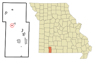
McCord Bend is a village in Stone County, Missouri, United States. The population was 212 at the 2020 census. It is part of the Branson, Missouri Micropolitan Statistical Area.

<span class="mw-page-title-main">Williamsburg, Ohio</span> Village in Ohio, United States

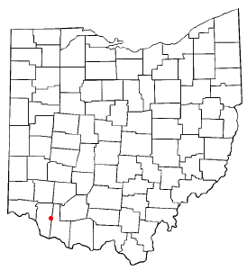
Williamsburg is a village in Clermont County, Ohio, United States. The population was 2,570 at the 2020 census.

<span class="mw-page-title-main">Lithopolis, Ohio</span> Village in Ohio, United States

Lithopolis is a village in Fairfield and Franklin counties in the U.S. state of Ohio. The population was 2,134 at the 2020 census.

<span class="mw-page-title-main">Metamora, Ohio</span> Village in Ohio, United States

Metamora is a village in Fulton County, Ohio, United States. The population was 566 at the 2020 census.

<span class="mw-page-title-main">Addyston, Ohio</span> Village in Ohio, United States

Addyston is a village in Miami Township, Hamilton County, Ohio, United States. Located along the Ohio River, it is a western suburb of the neighboring city of Cincinnati. The population was 927 at the 2020 census.

<span class="mw-page-title-main">Golf Manor, Ohio</span> Village in Ohio, United States

Golf Manor is a village in Hamilton County, Ohio, United States. It is almost completely surrounded by the Pleasant Ridge and Roselawn neighborhoods of Cincinnati. The population was 3,814 at the 2020 census.

<span class="mw-page-title-main">Woodlawn, Ohio</span> Village in Ohio, United States

Woodlawn is a village in Hamilton County, Ohio, United States. The population was 3,916 at the 2020 census.

<span class="mw-page-title-main">Rayland, Ohio</span> Village in Ohio, United States

Rayland is a village in southern Jefferson County, Ohio, United States, along the Ohio River. The population was 389 at the 2020 census. It is part of the Weirton–Steubenville metropolitan area.

<span class="mw-page-title-main">Hebron, Ohio</span> Village in Ohio, USA

Hebron is a village in Licking County, Ohio, United States. The population was 2,326 at the 2020 census.

<span class="mw-page-title-main">Beloit, Ohio</span> Village in Ohio, United States

Beloit is a village in southwestern Mahoning County, Ohio, United States. The population was 903 at the 2020 census. It is part of the Youngstown–Warren metropolitan area.

<span class="mw-page-title-main">Fulton, Ohio</span> Village in Ohio, United States

Fulton is a village in Morrow County, Ohio, United States. The population was 250 at the 2020 census. Fulton is south of Mount Gilead, the county seat.

<span class="mw-page-title-main">McDonald, Ohio</span> Village in Ohio, United States

McDonald is a village in southern Trumbull County, Ohio, United States, along the Mahoning River. The population was 3,172 at the 2020 census. It is a suburb of the Youngstown–Warren metropolitan area.

<span class="mw-page-title-main">Reedsville, Wisconsin</span> Village in Wisconsin, United States

Reedsville is a village in Manitowoc County, Wisconsin, United States. The population was 1,195 at the 2020 census.

<span class="mw-page-title-main">Butler, Waukesha County, Wisconsin</span> Village in Wisconsin, United States

Butler is a village in Waukesha County, Wisconsin, United States. The population was 1,787 at the 2020 census.

<span class="mw-page-title-main">Lisbon, Waukesha County, Wisconsin</span> Village in Wisconsin, United States

Lisbon is a village in Waukesha County, Wisconsin, United States. The population was 10,477 at the 2020 census. The unincorporated communities of Colgate and Lake Five are located partially in the village.

<span class="mw-page-title-main">Spring Valley, Wisconsin</span> Village in Wisconsin, United States

Spring Valley is a village in Pierce and St. Croix counties in Wisconsin, United States. The population was 1,401 at the 2020 census. Of those, 1,390 were in Pierce County and 11 in St. Croix County. The village is mostly within the Town of Spring Lake in Pierce County. Small parts also lie in the Town of Gilman, also in Pierce County, and the Town of Cady in St. Croix County.

References

  1. "2019 U.S. Gazetteer Files". United States Census Bureau. Retrieved August 7, 2020.
  2. 1 2 "US Board on Geographic Names". United States Geological Survey. October 25, 2007. Retrieved January 31, 2008.
  3. 1 2 "U.S. Census website". United States Census Bureau . Retrieved November 18, 2012.
  4. 1 2 "U.S. Census website". United States Census Bureau . Retrieved January 31, 2008.
  5. "A Brief Introduction to Lannon Stone". Street Directory. Retrieved July 2, 2016.
  6. Ruth Schmidt (c. 1980). "Lannon and its quarries". Sussex-Lisbon Area Historical Society, Inc.
  7. "The Village of Lannon". Village of Lannon. Retrieved October 18, 2022.
  8. "Halquist Stone". Halquist Stone. Archived from the original on July 14, 2016. Retrieved July 2, 2016.
  9. "Lannon Stone". Bridgehunter. Retrieved July 2, 2016.
  10. "Lannon Stone: Dolomite Unearthed". Geocaching. Retrieved July 2, 2016.
  11. "US Gazetteer files: 2010, 2000, and 1990". United States Census Bureau. February 12, 2011. Retrieved April 23, 2011.
  12. "US Gazetteer files 2010". United States Census Bureau. Archived from the original on July 2, 2012. Retrieved November 18, 2012.
  13. "Census of Population and Housing". Census.gov. Retrieved June 4, 2015.
  14. "Explore Census Data". data.census.gov. Retrieved May 1, 2024.
  15. "2020 CENSUS - SCHOOL DISTRICT REFERENCE MAP: Waukesha County, WI" (PDF). U.S. Census Bureau . Retrieved March 13, 2023.
  16. "Growing. Faithfully. Together" . Retrieved January 20, 2020.
  17. JR Radcliffe (April 22, 2020). "40 years ago, the first live ESPN game ever broadcast was a slow-pitch softball game in Wisconsin. How did it happen?". Milwaukee Journal Sentinel. Retrieved August 14, 2020.