Fraser, Colorado

Last updated

Fraser, Colorado
Town of Fraser [1]
Cozens Ranch Museum (Fraser,Colorado).jpg
Grand County Colorado Incorporated and Unincorporated areas Fraser Highlighted 0828305.svg
Location of the Town of Fraser in Grand County, Colorado.
Usa edcp location map.svg
Red pog.svg
Fraser
Location of the Town of Fraser in the United States.
Coordinates: 39°55′49″N105°48′11″W / 39.93028°N 105.80306°W / 39.93028; -105.80306
Country Flag of the United States.svg  United States
State Flag of Colorado.svg  Colorado
County Grand County [1]
Established1871
Incorporated (town) June 15, 1953 [2]
Government
  Type Statutory Town [1] [3]
  MayorBrian Cerkvenik [3]
Area
[4]
  Total3.462 sq mi (8.966 km2)
  Land3.457 sq mi (8.953 km2)
  Water0.005 sq mi (0.013 km2)
Elevation
[5]
8,813 ft (2,686 m)
Population
 (2020) [6]
  Total1,400
  Density400/sq mi (160/km2)
   Grand County
15,717
Time zone UTC−07:00 (MST)
  Summer (DST) UTC−06:00 (MDT)
ZIP code [7]
80442
Area code 970
FIPS code 08-28305
GNIS feature ID2412655 [5]
Website www.frasercolorado.com

The Town of Fraser is a Statutory Town located in Grand County, Colorado, United States. [1] The town population was 1,400 at the 2020 United States Census, a +14.38% increase since the 2010 United States Census. [4] The town is situated in Middle Park in the valley of the Fraser River along U.S. Highway 40. Its location northwest of Winter Park, the location of a popular ski resort, has provided growth in recent years with new condominium and other real estate developments.

Contents

History

Fraser was incorporated in 1953. [2] A post office called Fraser has been in operation since 1876. [8] The town derives its name from Reuben Frazer, a pioneer settler. [9]

Geography

Fraser is located in southeastern Grand County. [10] It is bordered to the south by the town of Winter Park and to the north by unincorporated Tabernash. U.S. Route 40 leads south and east across Berthoud Pass 71 miles (114 km) to Denver, and northwest 15 miles (24 km) to Granby, the largest town in Grand County.

At the 2020 United States Census, the town had a total area of 2,216 acres (8.966 km2) including 3.2 acres (0.013 km2) of water. [4] The Fraser River passes through the east side of town, flowing northward toward the Colorado River.

Climate

Fraser, with an annual mean temperature of 38.0 °F (3.3 °C) (or 34.8 °F (1.6 °C) based on another station in town) is one of the coldest incorporated towns in the lower 48 states. It can and does get frost year-round, totaling 287.3 nights under 32 °F (0 °C), rivalled only by towns in northern Alaska and Bodie, California, among currently inhabited localities in the United States. The total of 63.4 nights under 0 °F (−17.8 °C) is also among the highest in the contiguous 48 states, but the 59.9 days with highs not topping freezing is exceeded by substantial areas of North Dakota, Minnesota, northern Wisconsin and the Upper Peninsula of Michigan. Both Fraser and International Falls, Minnesota, have claimed the title "Icebox of the Nation", which has caused conflict between the two towns over the years. [11]

According to the Köppen climate classification system, Fraser has a subarctic climate, abbreviated Dfc on climate maps. The hottest temperature recorded in Fraser is 93 °F (33.9 °C) on August 1, 1969, and the coldest −43 °F (−41.7 °C) on January 10, 1962. The wettest calendar year has been 1957 with 30.33 inches (770.4 mm) and the driest 1944 with 11.04 inches (280.4 mm), whilst the most precipitation in one month has been 7.69 inches (195.3 mm) in September 1961. Snowfall is naturally heavy at 143.2 inches (3.64 m) and has ranged up to 82.4 inches (2.09 m) in February 1936 and 275.5 inches (7.00 m) from July 1926 to June 1927.

A freeze has been recorded for every single date of the year, one of the only locations in the entire United States to hold that record. [12]

Climate data for Fraser, Colorado, 19912020 normals, extremes 1989present
MonthJanFebMarAprMayJunJulAugSepOctNovDecYear
Record high °F (°C)50
(10)
53
(12)
65
(18)
74
(23)
81
(27)
87
(31)
93
(34)
84
(29)
82
(28)
75
(24)
65
(18)
53
(12)
93
(34)
Mean maximum °F (°C)42.0
(5.6)
46.1
(7.8)
54.8
(12.7)
64.7
(18.2)
74.1
(23.4)
81.0
(27.2)
83.3
(28.5)
81.2
(27.3)
76.7
(24.8)
69.1
(20.6)
55.3
(12.9)
44.1
(6.7)
83.7
(28.7)
Mean daily maximum °F (°C)30.8
(−0.7)
34.4
(1.3)
42.7
(5.9)
51.1
(10.6)
62.1
(16.7)
72.4
(22.4)
76.8
(24.9)
74.5
(23.6)
68.0
(20.0)
55.7
(13.2)
41.1
(5.1)
30.7
(−0.7)
53.4
(11.9)
Daily mean °F (°C)14.9
(−9.5)
18.2
(−7.7)
26.7
(−2.9)
35.4
(1.9)
44.5
(6.9)
52.5
(11.4)
57.4
(14.1)
55.6
(13.1)
48.6
(9.2)
38.3
(3.5)
25.3
(−3.7)
15.0
(−9.4)
36.0
(2.2)
Mean daily minimum °F (°C)−0.9
(−18.3)
2.0
(−16.7)
10.7
(−11.8)
19.8
(−6.8)
26.9
(−2.8)
32.6
(0.3)
38.0
(3.3)
36.8
(2.7)
29.1
(−1.6)
20.9
(−6.2)
9.5
(−12.5)
−0.8
(−18.2)
18.7
(−7.4)
Mean minimum °F (°C)−25.9
(−32.2)
−23.5
(−30.8)
−15.0
(−26.1)
1.1
(−17.2)
16.0
(−8.9)
23.8
(−4.6)
29.6
(−1.3)
28.4
(−2.0)
17.5
(−8.1)
3.2
(−16.0)
−15.0
(−26.1)
−24.3
(−31.3)
−30.9
(−34.9)
Record low °F (°C)−34
(−37)
−43
(−42)
−31
(−35)
−19
(−28)
3
(−16)
20
(−7)
23
(−5)
24
(−4)
7
(−14)
−19
(−28)
−30
(−34)
−41
(−41)
−43
(−42)
Average precipitation inches (mm)1.94
(49)
1.43
(36)
1.79
(45)
2.04
(52)
1.27
(32)
1.18
(30)
1.90
(48)
1.73
(44)
1.63
(41)
1.62
(41)
1.37
(35)
1.68
(43)
19.58
(496)
Average snowfall inches (cm)24.7
(63)
24.7
(63)
19.4
(49)
18.6
(47)
3.0
(7.6)
0.4
(1.0)
0.0
(0.0)
0.0
(0.0)
1.2
(3.0)
9.5
(24)
16.2
(41)
25.5
(65)
143.2
(363.6)
Average precipitation days (≥ 0.01 in)10.710.88.38.87.45.88.911.17.96.97.910.4104.9
Average snowy days (≥ 0.1 in)10.610.87.46.00.80.10.00.00.53.37.410.557.4
Source 1: NOAA [13]
Source 2: National Weather Service [14]

Icebox of the Nation

Downtown Fraser, Colorado, April 2005 DSCN2504 frasercolorado e 600.jpg
Downtown Fraser, Colorado, April 2005

Fraser, Colorado has been in a dispute with International Falls, Minnesota since 1956 over use of the trademark "Icebox of the Nation." [15] After several years of legal battles, the United States Patent and Trademark Office officially registered the slogan with International Falls on January 29, 2008. [16]

Demographics

Historical population
CensusPop.Note
1960 253
1970 221−12.6%
1980 470112.7%
1990 57522.3%
2000 91058.3%
2010 1,22434.5%
2020 1,40014.4%
U.S. Decennial Census

As of the census [17] of 2000, there were 910 people, 410 households, and 191 families residing in the town. The population density was 491.1 inhabitants per square mile (189.6/km2). There were 622 housing units at an average density of 335.7 per square mile (129.6/km2). The racial makeup of the town was 94.51% White, 0.88% African American, 0.88% Native American, 0.88% Asian, 0.22% Pacific Islander, 1.10% from other races, and 1.54% from two or more races. Hispanic or Latino of any race were 3.30% of the population.

There were 410 households, out of which 25.1% had children under the age of 18 living with them, 33.2% were married couples living together, 9.0% had a female householder with no husband present, and 53.2% were non-families. 27.6% of all households were made up of individuals, and 3.2% had someone living alone who was 65 years of age or older. The average household size was 2.21 and the average family size was 2.71.

In the town, the population was spread out, with 17.9% under the age of 18, 14.2% from 18 to 24, 46.2% from 25 to 44, 18.0% from 45 to 64, and 3.7% who were 65 years of age or older. The median age was 31 years. For every 100 females, there were 129.8 males. For every 100 females age 18 and over, there were 130.6 males.

The median income for a household in the town was $38,173, and the median income for a family was $39,643. Males had a median income of $29,583 versus $26,346 for females. The per capita income for the town was $20,628. About 11.1% of families and 8.8% of the population were below the poverty line, including 9.8% of those under age 18 and none of those age 65 or over.

Infrastructure

Transportation

Amtrak provides regular service to Fraser and nearby Winter Park (station code: WIP), operating its California Zephyr daily in each direction between Chicago, Illinois and Emeryville, California in the San Francisco Bay Area. In 2015, Amtrak also resumed seasonal ski train service to the Winter Park Resort. [18] The new Winter Park Express resumed ski train service that had been provided to the resort by Denver and Rio Grande Western Railroad's Ski Train for nearly 70 years. [19]

Other transportation options include the Bustang, which replaced the Greyhound bus, and Home James Transportation, which has provided shared shuttle and private charter transportation since 1982.

Notable people

See also

Related Research Articles

<span class="mw-page-title-main">Telluride, Colorado</span> Town in Colorado, United States

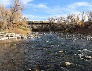
Telluride is the county seat and most populous town of San Miguel County in the southwestern portion of the U.S. state of Colorado. The town is a former silver mining camp on the San Miguel River in the western San Juan Mountains. The first gold mining claim was made in the mountains above Telluride in 1875, and early settlement of what is now Telluride followed. The town was founded in 1878 as "Columbia", but due to confusion with a California town of the same name, was renamed Telluride in 1887 for the gold telluride minerals found in other parts of Colorado. These telluride minerals were never found near Telluride, but the area's mines for some years provided zinc, lead, copper, silver, and other gold ores.

<span class="mw-page-title-main">Aspen, Colorado</span> City in Colorado, United States

Aspen is a home rule municipality that is the county seat and the most populous municipality of Pitkin County, Colorado, United States. The city population was 7,004 at the 2020 United States Census. Aspen is in a remote area of the Rocky Mountains' Sawatch Range and Elk Mountains, along the Roaring Fork River at an elevation just below 8,000 feet (2,400 m) above sea level on the Western Slope, 11 miles (18 km) west of the Continental Divide. Aspen is now a part of the Glenwood Springs, CO Micropolitan Statistical Area.

<span class="mw-page-title-main">Grand County, Colorado</span> County in Colorado, United States

Grand County is a county located in the U.S. state of Colorado. As of the 2020 census, the population was 15,717. The county seat is Hot Sulphur Springs.

<span class="mw-page-title-main">Truckee, California</span> Town in Nevada County, California, United States

Truckee is an incorporated town in Nevada County, California, United States. As of the 2010 United States Census, the population was 16,180, reflecting an increase of 2,316 from the 13,864 counted in the 2000 Census and having the 316th highest population in California and 2114th in the United States.

<span class="mw-page-title-main">Georgetown, Colorado</span> Town in Colorado, United States

Georgetown is the territorial charter municipality that is the county seat of Clear Creek County, Colorado, United States. The town population was 1,118 at the 2020 United States Census. The former silver mining camp along Clear Creek in the Front Range of the Rocky Mountains was established in 1859 during the Pike's Peak Gold Rush. The federally designated Georgetown-Silver Plume Historic District comprises Georgetown, the neighboring town of Silver Plume, and the Georgetown Loop Historic Mining & Railroad Park between the two towns. The Georgetown Post Office has the ZIP code 80444.

<span class="mw-page-title-main">Eagle, Colorado</span> Town in Colorado, United States

Eagle is the Statutory Town that is the county seat of Eagle County, Colorado, United States. The town population was 7,511 at the 2020 United States Census, a +15.41% increase since the 2010 United States Census. Eagle is the part of the Edwards, CO Micropolitan Statistical Area.

<span class="mw-page-title-main">Vail, Colorado</span> Town in Colorado, United States

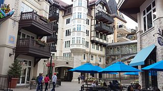
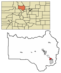
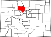
Vail is a home rule municipality in Eagle County, Colorado, United States. The population of the town was 4,835 in 2020. Home to Vail Ski Resort, the largest ski mountain in Colorado, the town is known for its hotels, dining, and for the numerous events the city hosts annually, such as the Vail Film Festival, Vail Resorts Snow Days, and Bravo! Vail.

<span class="mw-page-title-main">Granby, Colorado</span> Town in Colorado, United States

The Town of Granby is the Statutory Town that is the most populous municipality in Grand County, Colorado, United States. The town population was 2,079 at the 2020 United States Census. Granby is situated along U.S. Highway 40 in the Middle Park basin, and it is about 85 miles (137 km) northwest of Denver and 14 miles (23 km) southwest of Rocky Mountain National Park.

<span class="mw-page-title-main">Winter Park, Colorado</span> Town in Colorado, United States

Winter Park is a home rule municipality in Grand County, Colorado, United States. The permanent population was 1,033 at the 2020 census, although with 2,572 housing units within the town limits the seasonal population can be much higher.

<span class="mw-page-title-main">Crested Butte, Colorado</span> Town in Colorado, United States

Crested Butte is a home rule municipality located in Gunnison County, Colorado, United States. The town population was 1,639 at the 2020 United States Census. A former coal mining town nestled in the Slate River Valley, Crested Butte is now known as a destination for skiing, mountain biking, and outdoor activities.

<span class="mw-page-title-main">Gunnison, Colorado</span> City in Colorado, United States

Gunnison is a home rule municipality that is the county seat and the most populous municipality of Gunnison County, Colorado. The city population was 6,560 at the 2020 United States Census. The city was named in honor of John W. Gunnison, a United States Army officer who surveyed for a transcontinental railroad in 1853. Gunnison is a college town, home to Western Colorado University.

<span class="mw-page-title-main">Alma, Colorado</span> Town in Park County, Colorado, United States

Alma is a statutory town in Park County, Colorado, United States. The town population was 296 at the 2020 United States Census. Alma is located West and South of the Denver-Aurora-Lakewood, CO Metropolitan Statistical Area and the Front Range Urban Corridor.

<span class="mw-page-title-main">Rye, Colorado</span> Town in Colorado, United States

Rye is a Statutory Town in Pueblo County, Colorado, United States. The population was 206 at the 2020 census.

<span class="mw-page-title-main">Steamboat Springs, Colorado</span> City in Colorado, United States

Steamboat Springs is a home rule municipality that is the county seat and the most populous municipality of Routt County, Colorado. The population was 13,224 at the 2020 census. Steamboat Springs is the principal city of the Steamboat Springs Micropolitan Statistical Area, and it is the largest city in northwestern Colorado.

<span class="mw-page-title-main">International Falls, Minnesota</span> City in Minnesota, United States

International Falls is a city in and the county seat of Koochiching County, Minnesota, United States. The population was 5,802 at the time of the 2020 census.

<span class="mw-page-title-main">Whitefish, Montana</span> City in Montana, United States

Whitefish is a city in Flathead County, Montana, United States. According to the 2020 United States Census, there were 7,751 people in the city.

<span class="mw-page-title-main">Brian Head, Utah</span> Town in Utah, United States

Brian Head is a town in Iron County, Utah, United States. The population was 83 at the 2010 census, a significant decrease from the 2000 figure of 118.

<span class="mw-page-title-main">Stowe, Vermont</span> Town in Vermont, United States

Stowe is a town in Lamoille County, Vermont, United States. The population was 5223 at the 2020 census. The town lies on Vermont Routes 108 and 100. It is nicknamed "The Ski Capital of the East" and is home to Stowe Mountain Resort, a ski facility with terrain on Mount Mansfield, the highest peak in Vermont, and Spruce Peak.

<span class="mw-page-title-main">Jackson, Wyoming</span> Town in Wyoming, United States

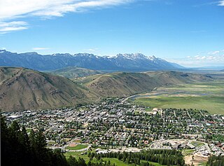
Jackson is a town in Teton County, Wyoming, United States. The population was 10,760 at the 2020 census, up from 9,577 in 2010. It is the largest town in Teton County and its county seat. Jackson is the principal town of the Jackson, WY-ID Micropolitan Statistical Area, which includes Teton County in Wyoming and Teton County in Idaho. The town, often familiarly or mistakenly called Jackson Hole, derives its name from the valley in which it is located. Jackson is a popular tourist destination due to its proximity to the ski resorts Jackson Hole Mountain, Snow King Mountain, and Grand Targhee, as well as Grand Teton National Park and Yellowstone National Park.

<span class="mw-page-title-main">Beech Mountain, North Carolina</span> Town in North Carolina, United States

Beech Mountain is a town in both Avery and Watauga counties in the U.S. state of North Carolina. As of the 2010 census, the town population was 320. The town is located atop Beech Mountain and is the highest town east of the Rocky Mountains at 5,506 ft in elevation. The nearest municipality at a higher elevation is Des Moines, New Mexico, some 1,220 miles away.

References

  1. 1 2 3 4 5 "Active Colorado Municipalities". Colorado Department of Local Affairs . Retrieved October 18, 2021.
  2. 1 2 "Local Government Filings". dola.colorado.gov. State of Colorado, Department of Local Affairs. Retrieved January 19, 2017.
  3. 1 2 "GOVERNMENT". Fraser, Colorado. Archived from the original on August 20, 2007. Retrieved September 22, 2007.
  4. 1 2 3 "Decennial Census P.L. 94-171 Redistricting Data". United States Census Bureau, United States Department of Commerce. August 12, 2021. Retrieved September 27, 2021.
  5. 1 2 U.S. Geological Survey Geographic Names Information System: Fraser, Colorado
  6. United States Census Bureau. "Fraser town; Colorado" . Retrieved April 23, 2023.
  7. "Look Up a ZIP Code™". usps.com. United States Postal Service . Retrieved January 19, 2017.
  8. "Post offices". Jim Forte Postal History. Archived from the original on March 6, 2016. Retrieved June 25, 2016.
  9. Dawson, John Frank (1954). Place names in Colorado: Why 700 communities were so named, 150 of Spanish or Indian origin. Denver, CO: J. Frank Dawson Publishing Co. p. 23.
  10. "US Gazetteer files: 2010, 2000, and 1990". United States Census Bureau. February 12, 2011. Retrieved April 23, 2011.
  11. Riccardi, Nicholas. "Dueling for 'Icebox of Nation' Archived 2012-02-07 at the Wayback Machine ." Journal Gazette. March 5, 2007. Retrieved on March 5, 2007.
  12. Team, National Weather Service Corporate Image Web. "National Weather Service Climate". w2.weather.gov. Retrieved April 11, 2020.
  13. "U.S. Climate Normals Quick Access". National Oceanic and Atmospheric Administration. Retrieved August 8, 2022.
  14. "NOAA Online Weather Data". National Weather Service. Retrieved August 8, 2022.
  15. Towns feud over claim to be nation's 'icebox', Associated Press, January 14, 2008. Retrieved on May 1, 2015.
  16. Trademark Status & Document Retrieval, United States Patent and Trademark Office, Accessed May 1, 2015.
  17. "U.S. Census website". United States Census Bureau . Retrieved January 31, 2008.
  18. "$75 Roundtrip Train Fares to Winter Park Resort | Amtrak". amtrak.com. Amtrak. Archived from the original on February 27, 2015. Retrieved January 19, 2017 via Internet Archive.
  19. Blevins, Jason (August 24, 2016). "Denver to Winter Park ski train returning for 2016-17: Tickets prices, schedules and details for new boarding platform at ski area will be announced Thursday". The Denver Post . Denver: Digital First Media . Retrieved December 19, 2016.