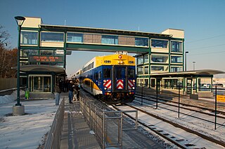
Fridley station is a commuter rail station in Fridley, Minnesota, located at Main Street NE and 61st Avenue NE. It is served by the Northstar Commuter Rail line. The station features bicycle lockers and two park and ride lots with a total capacity of 611 spaces. The commute time to downtown Minneapolis from this station is about 20 minutes.[2] The station has a single platform on one main track, which is accessible on either side of the tracks through a tunnel.
Platform of the Fridley Northstar station looking South towards MinneapolisPlatform of the Fridley Northstar station looking North
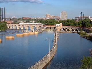
The double tracked main line for the BNSF Railwaytranscontinental railroad travels through Fridley after leaving Minneapolis. It runs parallel to the Mississippi River. The former Northern Pacific Railway and Great Northern Railway parallel main lines form this double track main. Fridley had been served by a flag stop station at Mississippi Boulevard between East River Road and University Avenue by both railroads.[3][4] In 1909, A "small shed used jointly as a depot serves the patrons of both roads" was reported.[5] The Minneapolis, Anoka and Cuyuna Range Railway, whose tracks ran along East River Road also had a station at Mississippi Boulevard. That location is 1/2 mile from the current station. One mile further north from the Mississippi Boulevard station was another station called Belt Line Junction.[6]
With the elimination of commuter service to Anoka, Fridley had not been served by commuter rail. Metro Transit buses extend through Fridley.
The Fridley station was planned as part of the Northstar Commuter rail project. The cost of construction was $9.9 million. The station was eliminated to save money because of a federal funding shortage. In late October 2008, the Counties Transit Improvement Board, which oversees spending of the new quarter-cent transit sales tax approved this year by the Minnesota state Legislature and five Twin Cities metro-area counties, decided to make the Fridley project one of its first funding priorities.[7]
The connecting tunnel was completed by BNSF Railway crews over the Memorial Day weekend in May 2008 because the City of Fridley committed money to the project and spent $3.2 million to acquire 10 acres (40,000m2) for parking.[7]
Third main line
The Fridley station is at the westbound yard limit of the BNSF Railway Northtown classification yard. There are multiple rail sidings in the area on both sides of the double track main line. The current station has only one side of the platform in use, requiring the Northstar train to be on that track when traveling inbound to or outbound from Minneapolis. Trains cross to and from that track at Coon Creek Junction. The eventual plan is that BNSF will construct a third main line in the area, running from East Interstate (the bridge over Interstate 694) to Coon Creek Junction in Coon Rapids.[8] This is a Transportation Investments Generating Economic Recovery (TIGER) grant application submitted to the American Recovery and Reinvestment Act. The third main line would improve capacity on the busiest rail corridor in the Twin Cities metropolitan area.[8][9] In July 2009, this segment hosted 63 trains per day, before the 12 daily trips for Northstar are added. At Coon Creek Junction, 12 trains per day cut off to the Duluth line. The completion of the third main line will include construction of the Foley Boulevard station and allow for 22 more passenger trains per day for Northstar, the proposed Northern Lights Express, Amtrak, and possibly other services.[8]
↑ Northern Pacific Time Tables, June 1926, Northern Pacific Railway, A. B. Smith, Passenger Traffic Manager, St. Paul, MN
↑ Great Northern Time Tables July 1928, Great Northern Railway A. J. Dickensen Passenger Traffic Manager, St. Paul, MN
↑ Annual Report of the Railroad and Warehouse Commission of Minnesota. United States: Office of the Railroad and Warehouse Commission, 1909.
↑ Railroads in Minnesota 1862–1956. National Register of Historic places Section E Statement of Historic contexts. Continuation Sheet NPS form 10-900a. United States Department of the Interior
Fridley is a city in Anoka County, Minnesota, United States. Its population was 29,590 at the 2020 census. It was first settled as a placed named Manomin where Rice Creek flows into the Mississippi river and the Red River Oxcart trail crosses the creek. Fridley was incorporated in 1949 as a village, and became a city in 1957. It is part of the Minneapolis–Saint Paul metropolitan area as a northern "first-ring" or "inner-ring" suburb. Most of the growth in Fridley occurred between 1950 and 1970. Fridley borders Minneapolis to the southwest. Neighboring first-ring suburbs are Columbia Heights to the south and Brooklyn Center to the west, across the Mississippi River.
The Metro Blue Line is a 12-mile (19.3 km) light rail line in Hennepin County, Minnesota, that is part of the Metro network. It travels from downtown Minneapolis to Minneapolis–Saint Paul International Airport and the southern suburb of Bloomington. Formerly the Hiawatha Line prior to May 2013, the line was originally named after the Milwaukee Road's Hiawatha passenger train and Hiawatha Avenue, reusing infrastructure from the former and running parallel to the latter for a portion of the route. The line opened June 26, 2004, and was the first light rail service in Minnesota. An extension, Bottineau LRT, is planned to open in 2028.
The Northstar Line is a commuter rail route in the US state of Minnesota. Northstar runs 40 miles (64 km) from Big Lake to downtown Minneapolis at Target Field using existing track and right-of-way owned by the BNSF Railway. Passenger service began on November 16, 2009. The rail line serves part of the Northstar Corridor between Minneapolis and St. Cloud. Planning for the line began in 1997 when the Northstar Corridor Development Authority (NCDA) was formed. The corridor is also served by Interstate 94 and U.S. Highway 10. In 2023, the system had a ridership of 142,200, or about 500 per weekday as of the fourth quarter of 2023.
Saint Paul Union Depot is a historic railroad station and intermodal transit hub in the Lowertown neighborhood of Saint Paul, Minnesota. It serves light rail, intercity rail, intercity bus, and local bus services.
Transportation in the U.S. State of Minnesota consists of a complex network of roadways, railways, waterways and airports. The transportation system is generally overseen by the Minnesota Department of Transportation, a cabinet-level agency of the state government. Additionally, regional governments such as the Metropolitan Council have authority over regional planning for the transportation system and local governments such as cities and counties oversee the local transportation network.
Target Field station is a multimodal commuter train and light rail station in Minneapolis, Minnesota. Located in the North Loop area of Downtown Minneapolis, the station is named for Target Field, the Minnesota Twins baseball stadium. METRO Blue Line light rail service started on November 14, 2009; Northstar Line commuter rail service started November 16, 2009; METRO Green Line light rail service started on June 14, 2014.
The Bottineau LRT is a proposed light rail line extension in the Minneapolis – Saint Paul Metro area, projected to run northwest from Target Field station in downtown Minneapolis along County Road 81 to Brooklyn Park.
There are several passenger rail projects being discussed in Minnesota. There is one existing commuter rail service in the state, the Northstar Line, and one existing long-distance intercity rail service, the Empire Builder. Future projects include a mixture of short-distance commuter rail and medium-distance regional rail lines which would run from the Twin Cities outward to neighboring states and perhaps Canada.
The Minneapolis Great Northern Depot, also known as Great Northern Station, was a passenger railroad station which served Minneapolis, Minnesota, USA. It was built in 1913 and demolished in 1978. It was located on Hennepin Avenue next to the Hennepin Avenue Bridge and across the street from the main Minneapolis Post Office.
The Northern Lights Express (NLX) is a planned higher-speed rail service that would run 155 miles (249 km) between Minneapolis and Duluth primarily in the U.S. state of Minnesota. A portion of the proposed line would run through neighboring Wisconsin to serve Duluth's "Twin Port" of Superior. Plans are to upgrade an existing BNSF Railway freight line to allow trains to travel at up to 90 miles per hour (145 km/h). The train service is said to provide an alternative to traveling Interstate 35 between Duluth and the Twin Cities or to other destinations along the line such as the casino in Hinckley.
Coon Rapids–Riverdale station is a commuter rail station in Coon Rapids, Minnesota, located at 3050 Northdale Boulevard NW, south of the Riverdale shopping centers. It is served by the Northstar Commuter Rail line. The station features bicycle lockers and a park and ride lot with capacity for 466 vehicles. The commute time to downtown Minneapolis from this station is about 28 minutes. The fare to downtown Minneapolis from this station is $3.25 at all times; the fare to and from any other station is $3.25 on weekdays and $2.75 on weekends and holidays.
Anoka station is a commuter rail station in Anoka, Minnesota, located at 2718 4th Avenue. It is served by the Northstar Commuter Rail line. The station features bicycle lockers and two park and ride lots. The north lot has 181 spaces and the south lot has 196 spaces, with a total capacity of 377 vehicles. The commute time to downtown Minneapolis from this station is about 32 minutes. In 2012, the weekday fare to downtown Minneapolis from this station was $3.00. The fare to and from any other station also was $3.00 on weekdays. In 2022, the weekday fares still were $3.00 to downtown Minneapolis and $3.00 to any other station.
The Staples Subdivision or Staples Sub is a railway line running about 227 miles (365 km) from Dilworth to Fridley, Minnesota. It is operated by BNSF Railway as part of their Northern Transcon and contains the busiest segment of mainline track in the state, the segment between Coon Rapids and Fridley. As of 2015, most of the route hosted an average of 60 trains per day, and there were 80 trains per day near Fridley. As of April 2022, the Staples Sub sees about 30-40 trains a day and it’s starting to rise to be more trains again on the line. The line meets the KO Subdivision in the west at East Dilworth, and runs to Interstate in Fridley, at the limits of Northtown Yard. Beyond Northtown, the rails continue as the Midway Subdivision and St. Paul Subdivision. U.S. Highway 10 closely follows the rail line for a majority of the distance between Dilworth and Fridley, Minnesota.
Coon Rapids–Foley Boulevard is a planned infill station on the Northstar commuter rail line in Coon Rapids, Minnesota, United States, at the site of a current Metro Transit park and ride facility. The station was originally included in Northstar plans, but it was cut in order to meet the Federal Transit Administration's cost-effectiveness index (CEI).
The St. Paul Subdivision or St. Paul Sub is a 30.9-mile (49.7 km) railway line running within the state of Minnesota. The line originates in Minneapolis and continues through neighboring Saint Paul, Minnesota and on into Saint Paul's southeastern suburbs along the Mississippi River. It is a segment of BNSF Railway's Northern Transcon which runs from Chicago, Illinois to Seattle, Washington. Between Minneapolis and Saint Paul themselves, this route runs on former Northern Pacific Railway trackage, and forms the northern set of BNSF tracks running through the Twin Cities. The companion route running slightly to the south is the Midway Subdivision, though the St. Paul Subdivision is the busier set of tracks, hosting about 59 trains per day as of April 2009. It is the second-busiest rail line in the state, after the segment of the Staples Subdivision between Fridley and Coon Rapids.
The Midway Subdivision or Midway Sub is a 12.4-mile (20.0 km) railway line in Minneapolis and Saint Paul, Minnesota. The line is part of BNSF Railway's Northern Transcon which runs from Chicago, Illinois to Seattle, Washington and Portland, Oregon. This is former Great Northern Railway trackage, and now forms the southern set of BNSF tracks running through the Twin Cities. The companion route running slightly to the north is the St. Paul Subdivision, former Northern Pacific Railway tracks. The Midway Subdivision hosts about 24 trains per day as of September 2015.
The Wayzata Subdivision or Wayzata Sub is a railway line that runs about 93 miles (150 km) from Willmar to Minneapolis, Minnesota. Currently operated by BNSF Railway, this was part of the Great Northern Railway's transcontinental line from Minneapolis to Seattle, Washington. Today, BNSF's Northern Transcon travels up the Staples Subdivision instead, which is a more direct route to Fargo, North Dakota. West of Target Field station the Wayzata Sub sees about 4-6 trains a day, consisting of manifest, grain, and ethanol traffic. The Wayzata Sub also occasionally sees other commodities such as coal and oil trains, and can sometimes receive intermodal or Amtrak reroutes when needed.
The Monticello Subdivision or Monticello Sub is a railway branch line that runs from the Wayzata Subdivision in Minneapolis to Monticello, Minnesota. Formerly operated by the Great Northern Railway and then Burlington Northern, it is now operated by BNSF Railway. It largely runs parallel to Broadway and Hennepin County Road 81 from Minneapolis to Rogers, and then Interstate 94 from Rogers to Monticello. Rails formerly continued on from today's Monticello Subdivision farther to the northwest along today's I-94 corridor all the way to Moorhead, Minnesota. It had been used for passenger service, such as with the Alexandrian.
Metro is a transit network in Minnesota serving the cities of Minneapolis and Saint Paul. It also provides service to some suburban areas. As of 2022, the system consists of two light rail lines and five bus rapid transit (BRT) lines all of which are operated by the local public transit company: Metro Transit. The five lines connect Downtown Minneapolis and St Paul with the Bloomington, Minneapolis-St Paul International Airport, Roseville, Richfield, Burnsville and Brooklyn Center.
This page is based on this Wikipedia article Text is available under the CC BY-SA 4.0 license; additional terms may apply. Images, videos and audio are available under their respective licenses.