Frithville

Last updated

Frithville
St Peter, Frithville - geograph.org.uk - 432788.jpg
St Peter's Church, Frithville
Lincolnshire UK location map.svg
Red pog.svg
Frithville
Location within Lincolnshire
Population568 (2011)
OS grid reference TF322502
  London 100 mi (160 km)  S
Civil parish
  • Frithville and Westville
District
Shire county
Region
Country England
Sovereign state United Kingdom
Post town Boston
Postcode district PE22
Police Lincolnshire
Fire Lincolnshire
Ambulance East Midlands
UK Parliament
List of places
UK
England
Lincolnshire
53°02′00″N0°01′43″W / 53.033368°N 0.028576°W / 53.033368; -0.028576

Frithville is a village and former civil parish, now in the parish of Frithville and Westville in the East Lindsey district of Lincolnshire, England. The population of Frithville and Westville was 549 in 2001, increasing at the 2011 census to 568. [1] It is served by the B1183 road, and is approximately 4 miles (6 km) north of Boston, in the West Fen fenland area.

Contents

History

The name Frith comes from the Old English fyrhoe, meaning wood or woody pasture. The first mention of Frith in historical records is in 1323 when it was called Le Frith; in 1512 it was referred to as "The Kings Frith beside Boston". [2] Formerly extra-parochial land, Frithville was enclosed in 1802. This was one of seven new townships north of Boston that were organized in 1812. [3]

The civil townships were organized at the same time as this remote area had major projects in the three fens for installing drains to claim the land for agricultural development. This continues to be a rural area with an economy based on agriculture. Chief crops in the late 19th century were wheat and beans. [4]

The Anglican church of Saint Peter was built in 1821, much later than many churches in Lincolnshire. It is among those built after 1810, known as Fens chapels or the Georgian group, for their style of architecture. Numerous churches in the shire predate the Protestant Reformation. St. Peter's is a Grade II listed building. [5] It is in the hamlet of Mount Pleasant, which was included in the township of Frithville when the latter was organized. It is one of several churches built in the area under the Fen Churches Act of 1816. [5] In 1885 Kelly's Directory reported that the brick-built church and the vicarage were erected simultaneously. The parish also had a Wesleyan chapel. [4]

Frithville has a primary school and an agricultural shop.

Because of repeated flooding in the Fens, several drains were constructed through this area in the 19th century to reduce water damage to agriculture and settlements. Before the drains, the land was used largely for seasonal pasture. Those projects crossing Frithville include the West Fen Drain, the Twenty Foot Drain, and the Medlam Drain. In the 21st century, summer boaters travel the waterways for recreation.

Governance

There is a Frithville electoral ward. The population of this ward at the 2011 census was 1,920. [6]

In 1961 the parish of Frithville had a population of 627. [7] On 1 April 2005 the parish was abolished and merged with Westville to form "Frithville and Westville". [8]

Related Research Articles

<span class="mw-page-title-main">Algarkirk</span> Village and civil parish in the Borough of Boston in Lincolnshire, England

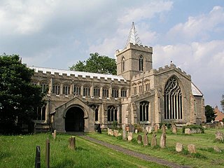
Algarkirk is a village and civil parish in the Borough of Boston in Lincolnshire, England. It is situated 6 miles (9.7 km) south-south-west from Boston and near the A16 road. It has a population of 406, falling to 386 at the 2011 census. An alternative village spelling is 'Algakirk'.

<span class="mw-page-title-main">Westville, Lincolnshire</span> Hamlet in the East Lindsey district of Lincolnshire, England

Westville is a hamlet in the East Lindsey district of Lincolnshire, England. It is situated 7 miles (11 km) north from Boston. Westville lies in the fen country close to the village of Frithville, with which it shares the civil parish of Frithville and Westville.

<span class="mw-page-title-main">Wyberton</span> Village in Lincolnshire, England

Wyberton is a village in Lincolnshire, England. It lies just south-west of Boston, and on the B1397 – the former A16 London Road – between Boston and Kirton. The A16 bisects the village. The population of the civil parish at the 2011 census was 3,747.

<span class="mw-page-title-main">Wrangle, Lincolnshire</span> Village in the Boston Borough of Lincolnshire, England

Wrangle is a village in the Boston Borough of Lincolnshire, England. It is situated approximately 9 miles (14 km) north-east from the town of Boston. The population of Wrangle civil parish in 2001 was 1,265, increasing to 1,397 at the 2011 census.

<span class="mw-page-title-main">Old Leake</span> Village and civil parish in Lincolnshire, England

Old Leake is a village and civil parish in Lincolnshire, England. The population of the civil parish at the 2011 census was 2,022.

Holland Fen with Brothertoft is a civil parish in Lincolnshire, England, consisting, as the name indicates, of Holland Fen and Brothertoft, but also includes the areas known as Pelhams Land, Harts Ground and Pepper Gowt Plot. The population of the civil parish at the 2011 census was 669.

<span class="mw-page-title-main">Amber Hill</span> Village and civil parish in Lincolnshire, England

Amber Hill is a village and civil parish in Lincolnshire, England, approximately 6 miles (10 km) west-north-west from Boston. The 2001 Census measured its population at 268, increasing to 294 at the 2011 census.

<span class="mw-page-title-main">Bicker, Lincolnshire</span> Village in Boston, Lincolnshire, England

Bicker is a village in the Borough of Boston, Lincolnshire, England. The population of the village was 941 at the 2011 census. It is situated approximately 9 miles (10 km) west-south-west from Boston, and on the A52 road.

<span class="mw-page-title-main">Binbrook</span> Village in England

Binbrook is a village and civil parish in the East Lindsey district of Lincolnshire, England. It is situated on the B1203 road, and 8 miles (13 km) north-east from Market Rasen.

<span class="mw-page-title-main">Billinghay</span> Village and civil parish in the North Kesteven district of Lincolnshire, England

Billinghay is a village and civil parish in the North Kesteven district of Lincolnshire, England. The village is situated approximately 7 miles (11 km) north-east from Sleaford, and lies on the B1189 Walcott road near its junction with the A153. Just south of the village towards Sleaford is North Kyme. According to the 2001 census the parish had a population of 1,808, increasinging to 2,190 at the 2011 census, increasinging to 2,203 at the 2021 census.

<span class="mw-page-title-main">Washingborough</span> Village in Lincolnshire, England

Washingborough is a village in the North Kesteven district in Lincolnshire, England. Located 3 miles (5 km) east of Lincoln and 18 miles (29 km) from Sleaford. The population in the 2001 census was 3,356, increasing to 3,482 at the 2011 census. It is situated on the lower slopes of Lincoln Cliff limestone escarpment where the River Witham breaks through it. The south side of Lincoln Cathedral and its three towers can be seen from the village centre.

<span class="mw-page-title-main">Sibsey</span> Village, civil parish and electoral ward in the East Lindsey district of Lincolnshire, England

Sibsey is a village, civil parish and electoral ward in the East Lindsey district of Lincolnshire, England. It is situated at the junction of the A16 and B1184 roads, 4 miles (6.4 km) north from Boston. Sibsey Northlands is to the north of the village. The Prime Meridian passes just to the west of Sibsey, crossing the Stone Bridge Drain canal. At the 2001 census, Sibsey had a population of 1,996, reducing to 1,979 at the 2011 Census.

<span class="mw-page-title-main">Mareham le Fen</span> Village in Lincolnshire, England

Mareham le Fen is a village and civil parish about 6 miles (10 km) south from the town of Horncastle, Lincolnshire, England. The hamlet of Mareham Gate lies about 0.5 miles (0.8 km) south from the village, and it is believed that the deserted medieval village (DMV) of Birkwood is situated nearby.

<span class="mw-page-title-main">Pinchbeck, Lincolnshire</span> Village and civil parish in the South Holland district of Lincolnshire, England

Pinchbeck is a village and civil parish in the South Holland district of Lincolnshire, England. The civil parish population was 5,153 at the 2001 census, 5,455 at the 2011 census and 6,011 at the 2021 census. It is situated 2 miles (3.2 km) north from the centre of Spalding.

<span class="mw-page-title-main">Friskney</span> Village and civil parish within the East Lindsey district of Lincolnshire, England

Friskney is a village and civil parish within the East Lindsey district of Lincolnshire, England.

<span class="mw-page-title-main">Midville, Lincolnshire</span> Small village and civil parish in the East Lindsey district of Lincolnshire, England

Midville is a small village and civil parish in the East Lindsey district of Lincolnshire, England. It is situated about 10 miles (16 km) north from Boston.

<span class="mw-page-title-main">Wildmore</span> Human settlement in England

Wildmore is a civil parish in the East Lindsey district of Lincolnshire, England. It is situated approximately 9 miles (14 km) north-west from the town of Boston and 11 miles (18 km) south from Horncastle.

<span class="mw-page-title-main">Thornton le Fen</span> Small civil parish in the East Lindsey district of Lincolnshire, England

Thornton Le Fen is a small civil parish in the East Lindsey district of Lincolnshire, England. It is situated approximately 4 miles (6 km) north from the town of Boston.

<span class="mw-page-title-main">Carrington, Lincolnshire</span> Village and civil parish in the East Lindsey district of Lincolnshire, England

Carrington is a village in the civil parish of Carrington and New Bolingbroke, in the East Lindsey district of Lincolnshire, England. It is situated approximately 7 miles (11 km) north from the market town of Boston.

<span class="mw-page-title-main">New Leake</span> Village and civil parish in the East Lindsey district of Lincolnshire, England

New Leake is a village and civil parish in the East Lindsey district of Lincolnshire, England. The population of the civil parish at the 2011 census was 323. It is situated 9 miles (14 km) north from Boston, and 10 miles (16 km) east from Coningsby.

References

  1. "Civil Parish population 2011". Neighbourhood Statistics. Office for National Statistics. Retrieved 19 August 2015.
  2. James Brown Johnston (1916). "The Place-names of England & Wales". E. P. Dutton & Co. Retrieved 16 April 2011.
  3. Historic England. "Frithville (354042)". Research records (formerly PastScape). Retrieved 2 August 2011.
  4. 1 2 Kelly's Directory of Lincolnshire with the Port of Hull, 1885, p. 399
  5. 1 2 Historic England. "Church of St Peter (1307173)". National Heritage List for England . Retrieved 2 August 2011.
  6. "Key Figures for 2011 Census: Key Statistics – Area: Frithville (Ward)". Neighbourhood Statistics. Office for National Statistics. Retrieved 7 November 2016.
  7. "Population statistics Frithville PA/Tn/CP through time". A Vision of Britain through Time . Retrieved 3 September 2023.
  8. "Lincolnshire Registration District". UKBMD. Retrieved 3 September 2023.