Geography of Kansas

Last updated
The Great Plains of Kansas Great Plains LCC (14285769265).jpg
The Great Plains of Kansas
Kanopolis State Park Kanopolissp.JPG
Kanopolis State Park

The U.S. state of Kansas is bordered by Nebraska to the north; Missouri to the east; Oklahoma to the south; and Colorado to the west. The state is divided into 105 counties with 628 cities, with its largest county by area being Butler County. [1] Kansas is located equidistant from the Pacific and Atlantic oceans. The geographic center of the 48 contiguous states is in Smith County near Lebanon. Until 1989, the Meades Ranch Triangulation Station in Osborne County was the geodetic center of North America: the central reference point for all maps of North America. The geographic center of Kansas is in Barton County.

Contents

Geology and Topography

Kansas is underlain by a sequence of horizontal to gently westward dipping sedimentary rocks. A sequence of Mississippian, Pennsylvanian and Permian rocks outcrop in the eastern and southern part of the state. The state's western half has exposures of Cretaceous through Tertiary sediments, the latter derived from the erosion of the uplifted Rocky Mountains to the west. These are underlain by older Paleozoic and Mesozoic sediments which correlate well with the outcrops to the east. The state's northeastern corner was subjected to glaciation in the Pleistocene and is covered by glacial drift and loess.

Physiographic regions of Kansas KS-PhysiographicDivisions.png
Physiographic regions of Kansas

Kansas has been divided into eleven different physiographic regions. [3]

The western two-thirds of the state, lying in the great central plain of the United States, has a generally flat or undulating surface, while the eastern third has many hills and forests. The land gradually rises from east to west; its altitude ranges from 684 ft (208 m) along the Verdigris River at Coffeyville in Montgomery County, to 4,039 ft (1,231 m) at Mount Sunflower, 0.5 miles (0.80 kilometers) from the Colorado border, in Wallace County. It is a common misconception that Kansas is the flattest state in the nation—in 2003, a tongue-in-cheek study famously declared the state "flatter than a pancake". [4] In fact, Kansas has a maximum topographic relief of 3,360 ft (1,020 m), [5] making it the 23rd flattest U.S. state measured by maximum relief. [6]

Features

Rivers

Spring River, Kansas Spring River 2006-07-03 2104.jpg
Spring River, Kansas

Nearly 75 mi (121 km) of the state's northeastern boundary is defined by the Missouri River. The Kansas River (locally known as the Kaw), formed by the junction of the Smoky Hill and Republican rivers at appropriately-named Junction City, joins the Missouri River at Kansas City, after a course of 170 mi (270 km) across the northeastern part of the state.

The Arkansas River (pronunciation varies), rising in Colorado, flows with a bending course for nearly 500 mi (800 km) across the western and southern parts of the state. With its tributaries, (the Little Arkansas, Ninnescah, Walnut, Cow Creek, Cimarron, Verdigris, and the Neosho), it forms the southern drainage system of the state.

Kansas's other rivers are the Saline and Solomon Rivers, tributaries of the Smoky Hill River; the Big Blue, Delaware, and Wakarusa, which flow into the Kansas River; and the Marais des Cygnes, a tributary of the Missouri River. Spring River is located between Riverton and Baxter Springs.

National parks and historic sites

Areas under the protection of the National Park Service include: [7]

Flora and fauna

In Kansas, there are currently 238 species of rare animals and 400 rare plants. [8] Among those include: Boechera laevigata , Virginia Rail, Cleft Ledge, Royal Fern, Turkey-tangle, Bobolink, Cave Salamander, Peregrine Falcon, and Black-footed ferret. [9] [10] Common animal species and grasses include: Crows, Deer, Lesser Prairie Chicken, Mice, Moles, Opossum, Prairie Dogs, Raccoon, Tripsacum dactyloides , Prairie Dropseed, Indian Grass, Little Bluestem, Switch Grass, Northern Sea Oats, Tussock Sedge, Sideoats Grama, and Big Bluestem. [11] [12]

Climate

Koppen climate types of Kansas, using 1991-2020 climate normals. Koppen Climate Types Kansas.png
Köppen climate types of Kansas, using 1991-2020 climate normals.
Clouds in northeastern Kansas Kansas Windmills.JPG
Clouds in northeastern Kansas
Kansas summer wheat and storm panorama Kansas Summer Wheat and Storm Panorama.jpg
Kansas summer wheat and storm panorama

According to the Köppen climate classification, Kansas's climate can be characterized in terms of three types: it has humid continental, semi-arid steppe, and humid subtropical. The eastern two-thirds of the state (especially the northeastern portion) has a humid continental climate, with cool to cold winters and hot, often humid summers. Most of the precipitation falls during both the summer and the spring.

The western third of the state—from roughly the U.S. Route 83 corridor westward—has a semi-arid steppe climate. Summers are hot, often very hot, and generally less humid. Winters are highly changeable between warm and very cold. The western region receives an average of about 16 inches (410 millimeters) of precipitation per year. Chinook winds in the winter can warm western Kansas all the way into the 80 degrees Fahrenheit (27 degrees Celsius) range.

The south-central and southeastern portions of the state, including the Wichita area, have a humid subtropical climate with hot and humid summers, milder winters, and more precipitation than elsewhere in Kansas. Some features of all three climates can be found in most of the state, with droughts and changeable weather between dry and humid not uncommon, and both warm and cold spells in the winter.

Temperatures in areas between U.S. Routes 83 and 81, as well as the southwestern portion of the state along and south of U.S. 50, reach 90 °F (32 °C) or above on most days of June, July, and August. High humidity added to the high temperatures sends the heat index into life-threatening territory, especially in Wichita, Hutchinson, Salina, Russell, Hays, and Great Bend. Temperatures are often higher in Dodge City, Garden City, and Liberal, but the heat index in those three cities is usually lower than the actual air temperature.

Although temperatures of 100 °F (38 °C) or higher are not as common in areas east of U.S. 81, higher humidity and the urban heat island effect lead most summer days to heat indices between 107 °F (42 °C) and 114 °F (46 °C) in Topeka, Lawrence, and the Kansas City metropolitan area. Also, combined with humidity between 85 and 95 percent, dangerous heat indices can be experienced at every hour of the day.

Precipitation ranges from about 47 inches (1,200 mm) annually in the state's southeast corner to about 16 inches (410 mm) in the southwest. Snowfall ranges from around 5 inches (130 mm) in the fringes of the south, to 35 inches (890 mm) in the far northwest. Frost-free days range from more than 200 days in the south, to 130 days in the northwest. Thus, Kansas is the country's ninth or tenth sunniest state, depending on the source. Western Kansas is as sunny as parts of California and Arizona.

Kansas is prone to severe weather, especially in the spring and the early-summer. Despite the frequent sunshine throughout much of the state, due to its location at a climatic boundary prone to intrusions of multiple air masses, the state is vulnerable to strong and severe thunderstorms. Some of these storms become supercell thunderstorms; these can produce some tornadoes, occasionally those of EF3 strength or higher. Kansas averages more than 50 tornadoes annually. [13] Severe thunderstorms sometimes drop some very large hail over Kansas as well. Furthermore, these storms can even bring in flash flooding and damaging straight line winds.

According to NOAA, the all-time highest temperature recorded in Kansas is (121 °F or 49.4 °C) on July 24, 1936, near Alton in Osborne County, and the all-time low is −40 °F (−40 °C) on February 13, 1905, near Lebanon in Smith County. Alton and Lebanon are approximately 50 miles (80 km) apart. [14]

Kansas's record high of 121 °F (49.4 °C) ties with North Dakota for the fifth-highest record high in an American state, behind California (134 °F or 56.7 °C), Arizona (128 °F or 53.3 °C), Nevada (125 °F or 51.7 °C), and New Mexico (122 °F or 50 °C). [15] [16]

Climate data

Monthly normal high and low temperatures for various Kansas cities (°F) [17]
CityJanFebMarAprMayJunJulAugSepOctNovDec
Concordia36/1743/2254/3164/4174/5285/6291/6788/6680/5668/4451/3040/21
Dodge City41/1948/2457/3167/4176/5287/6293/6791/6682/5670/4455/3044/22
Goodland39/1645/2053/2663/3572/4684/5689/6187/6078/5066/3850/2541/18
Topeka37/1744/2355/3366/4375/5384/6389/6888/6580/5669/4453/3241/22
Wichita40/2047/2557/3467/4476/5487/6493/6992/6882/5970/4755/3443/24
Climate data for Topeka (Köppen Cfa/Dfa) [lower-alpha 1]
MonthJanFebMarAprMayJunJulAugSepOctNovDecYear
Record high °F (°C)78
(26)
84
(29)
93
(34)
97
(36)
103
(39)
109
(43)
114
(46)
113
(45)
110
(43)
97
(36)
85
(29)
77
(25)
114
(46)
Mean maximum °F (°C)63.0
(17.2)
69.4
(20.8)
78.7
(25.9)
86.1
(30.1)
90.2
(32.3)
94.8
(34.9)
99.7
(37.6)
100.0
(37.8)
93.7
(34.3)
86.8
(30.4)
74.5
(23.6)
63.7
(17.6)
101.8
(38.8)
Mean daily maximum °F (°C)39.9
(4.4)
45.0
(7.2)
56.4
(13.6)
66.7
(19.3)
75.9
(24.4)
84.7
(29.3)
89.5
(31.9)
88.6
(31.4)
80.4
(26.9)
68.4
(20.2)
54.6
(12.6)
41.7
(5.4)
66.1
(18.9)
Daily mean °F (°C)29.7
(−1.3)
34.4
(1.3)
44.8
(7.1)
55.1
(12.8)
65.0
(18.3)
74.2
(23.4)
79.0
(26.1)
77.4
(25.2)
68.4
(20.2)
56.6
(13.7)
43.8
(6.6)
32.0
(0.0)
55.0
(12.8)
Mean daily minimum °F (°C)19.6
(−6.9)
23.8
(−4.6)
33.3
(0.7)
43.5
(6.4)
54.2
(12.3)
63.7
(17.6)
68.4
(20.2)
66.2
(19.0)
56.3
(13.5)
44.7
(7.1)
33.0
(0.6)
22.3
(−5.4)
44.2
(6.8)
Mean minimum °F (°C)0.2
(−17.7)
3.2
(−16.0)
15.7
(−9.1)
27.1
(−2.7)
38.8
(3.8)
50.4
(10.2)
56.6
(13.7)
53.4
(11.9)
38.8
(3.8)
27.9
(−2.3)
16.7
(−8.5)
3.1
(−16.1)
−6.3
(−21.3)
Record low °F (°C)−23
(−31)
−25
(−32)
−7
(−22)
10
(−12)
26
(−3)
36
(2)
43
(6)
40
(4)
29
(−2)
16
(−9)
−5
(−21)
−26
(−32)
−26
(−32)
Average precipitation inches (mm)0.86
(22)
1.32
(34)
2.49
(63)
3.53
(90)
4.91
(125)
5.40
(137)
3.82
(97)
4.24
(108)
3.66
(93)
3.03
(77)
1.85
(47)
1.35
(34)
36.46
(926)
Average snowfall inches (cm)4.9
(12)
4.5
(11)
1.6
(4.1)
0.3
(0.76)
0
(0)
0
(0)
0
(0)
0
(0)
0
(0)
0.3
(0.76)
1.0
(2.5)
5.2
(13)
17.8
(45)
Average precipitation days (≥ 0.01 in)5.56.39.09.711.611.58.78.67.88.16.86.099.6
Average snowy days (≥ 0.1 in)3.62.91.30.30000001.23.412.7
Average relative humidity (%)69.769.265.864.168.571.269.970.872.468.070.872.369.4
Mean monthly sunshine hours 177.4168.8212.6231.7268.5293.0326.9291.7233.4212.4157.8150.52,724.7
Percent possible sunshine 59565758606672696361525161
Source: NOAA (relative humidity and sun 1961–1990) [18] [19] [20]
Climate data for Wichita (Köppen Cfa)
MonthJanFebMarAprMayJunJulAugSepOctNovDecYear
Record high °F (°C)75
(24)
87
(31)
92
(33)
98
(37)
102
(39)
110
(43)
113
(45)
114
(46)
108
(42)
97
(36)
86
(30)
83
(28)
114
(46)
Mean maximum °F (°C)65.8
(18.8)
71.6
(22.0)
79.9
(26.6)
85.3
(29.6)
92.0
(33.3)
98.4
(36.9)
103.7
(39.8)
102.2
(39.0)
97.3
(36.3)
89.0
(31.7)
75.5
(24.2)
65.3
(18.5)
104.9
(40.5)
Mean daily maximum °F (°C)43.9
(6.6)
48.9
(9.4)
59.1
(15.1)
68.3
(20.2)
77.5
(25.3)
87.9
(31.1)
92.6
(33.7)
91.0
(32.8)
83.3
(28.5)
70.8
(21.6)
57.0
(13.9)
45.8
(7.7)
68.8
(20.4)
Daily mean °F (°C)33.2
(0.7)
37.6
(3.1)
47.4
(8.6)
56.5
(13.6)
66.7
(19.3)
76.9
(24.9)
81.5
(27.5)
79.9
(26.6)
71.7
(22.1)
59.0
(15.0)
45.8
(7.7)
35.6
(2.0)
57.7
(14.3)
Mean daily minimum °F (°C)22.5
(−5.3)
26.3
(−3.2)
35.7
(2.1)
44.8
(7.1)
55.9
(13.3)
65.9
(18.8)
70.4
(21.3)
68.8
(20.4)
60.1
(15.6)
47.2
(8.4)
34.7
(1.5)
25.4
(−3.7)
46.5
(8.1)
Mean minimum °F (°C)5.1
(−14.9)
8.4
(−13.1)
17.1
(−8.3)
28.2
(−2.1)
40.5
(4.7)
53.9
(12.2)
61.4
(16.3)
59.3
(15.2)
44.6
(7.0)
29.7
(−1.3)
17.9
(−7.8)
8.4
(−13.1)
1.0
(−17.2)
Record low °F (°C)−15
(−26)
−22
(−30)
−3
(−19)
15
(−9)
27
(−3)
43
(6)
51
(11)
45
(7)
31
(−1)
14
(−10)
1
(−17)
−16
(−27)
−22
(−30)
Average precipitation inches (mm)0.85
(22)
1.20
(30)
2.30
(58)
3.10
(79)
5.17
(131)
4.93
(125)
3.98
(101)
4.30
(109)
3.05
(77)
2.85
(72)
1.36
(35)
1.22
(31)
34.31
(871)
Average snowfall inches (cm)2.7
(6.9)
3.6
(9.1)
2.1
(5.3)
0.2
(0.51)
0.0
(0.0)
0.0
(0.0)
0.0
(0.0)
0.0
(0.0)
0.0
(0.0)
0.2
(0.51)
0.8
(2.0)
3.1
(7.9)
12.7
(32)
Average precipitation days (≥ 0.01 in)4.85.37.48.311.39.58.38.26.96.65.15.487.1
Average snowy days (≥ 0.1 in)2.72.21.00.30.00.00.00.00.00.20.62.29.2
Average relative humidity (%)69.968.363.862.867.064.358.961.166.865.170.071.765.8
Mean monthly sunshine hours 190.9186.4230.4257.8289.8305.0342.1309.2245.6226.3170.2168.72,922.4
Percent possible sunshine 62626265666976736665565766
Average ultraviolet index 235791010975326
Source: National Weather Service (relative humidity and sun 1961–1990); [21] [22] [23]
Climate data for Dodge City (Köppen BSk/Cfa) [lower-alpha 2]
MonthJanFebMarAprMayJunJulAugSepOctNovDecYear
Record high °F (°C)80
(27)
88
(31)
98
(37)
100
(38)
106
(41)
111
(44)
109
(43)
109
(43)
107
(42)
101
(38)
91
(33)
86
(30)
111
(44)
Mean maximum °F (°C)68.2
(20.1)
73.9
(23.3)
81.7
(27.6)
88.6
(31.4)
94.0
(34.4)
99.7
(37.6)
103.9
(39.9)
102.1
(38.9)
97.6
(36.4)
89.8
(32.1)
77.2
(25.1)
66.9
(19.4)
105.1
(40.6)
Mean daily maximum °F (°C)44.2
(6.8)
48.4
(9.1)
57.8
(14.3)
67.5
(19.7)
76.9
(24.9)
86.7
(30.4)
92.8
(33.8)
90.8
(32.7)
82.4
(28.0)
69.7
(20.9)
55.9
(13.3)
44.3
(6.8)
68.2
(20.1)
Daily mean °F (°C)32.3
(0.2)
36.0
(2.2)
44.5
(6.9)
54.0
(12.2)
64.3
(17.9)
74.0
(23.3)
79.7
(26.5)
78.2
(25.7)
69.3
(20.7)
56.6
(13.7)
43.2
(6.2)
32.9
(0.5)
55.4
(13.0)
Mean daily minimum °F (°C)20.1
(−6.6)
23.4
(−4.8)
31.0
(−0.6)
40.2
(4.6)
51.5
(10.8)
61.0
(16.1)
66.3
(19.1)
65.3
(18.5)
56.0
(13.3)
43.4
(6.3)
30.3
(−0.9)
21.2
(−6.0)
42.6
(5.9)
Mean minimum °F (°C)2.9
(−16.2)
4.7
(−15.2)
12.9
(−10.6)
24.7
(−4.1)
36.3
(2.4)
49.0
(9.4)
56.3
(13.5)
54.9
(12.7)
39.1
(3.9)
26.9
(−2.8)
13.4
(−10.3)
3.6
(−15.8)
−4.3
(−20.2)
Record low °F (°C)−20
(−29)
−26
(−32)
−15
(−26)
9
(−13)
19
(−7)
36
(2)
46
(8)
43
(6)
29
(−2)
10
(−12)
−13
(−25)
−21
(−29)
−26
(−32)
Average precipitation inches (mm)0.58
(15)
0.68
(17)
1.59
(40)
1.82
(46)
2.85
(72)
3.24
(82)
3.08
(78)
2.75
(70)
1.67
(42)
1.74
(44)
0.76
(19)
0.84
(21)
21.60
(549)
Average snowfall inches (cm)4.9
(12)
3.9
(9.9)
4.9
(12)
1.1
(2.8)
0
(0)
0
(0)
0
(0)
0
(0)
0
(0)
0.4
(1.0)
1.8
(4.6)
4.1
(10)
21.1
(54)
Average precipitation days (≥ 0.01 in)3.54.86.57.18.98.98.28.05.76.14.54.676.8
Average snowy days (≥ 0.1 in)3.42.82.30.6000000.21.23.213.7
Average relative humidity (%)65.964.560.557.562.559.955.258.461.958.264.366.661.3
Mean monthly sunshine hours 207.2201.6241.1270.0297.6332.9357.8319.0267.6248.8192.9189.23,125.7
Percent possible sunshine 67676568687580767271636370
Source: National Weather Service (relative humidity and sun 1961–1990) [24] [25] [26]

See also

Related Research Articles

<span class="mw-page-title-main">Kansas</span> U.S. state

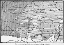
Kansas is a landlocked state in the Midwestern region of the United States. It borders Nebraska to the north; Missouri to the east; Oklahoma to the south; and Colorado to the west. Kansas is named after the Kansas River, in turn named after the Kansa people. Its capital is Topeka, and its most populous city is Wichita, however the largest urban area is the bi-state Kansas City, MO–KS metropolitan area.

<span class="mw-page-title-main">Cottonwood Falls, Kansas</span> City in Chase County, Kansas

Cottonwood Falls is the largest city and county seat of Chase County, Kansas, United States. As of the 2020 census, the population of the city was 851. It is located south of Strong City along the south side of the Cottonwood River.

<span class="mw-page-title-main">Ashland, Kansas</span> City in Clark County, Kansas

Ashland is a city in and the county seat of Clark County, Kansas, United States. As of the 2020 census, the population of the city was 783.

<span class="mw-page-title-main">Ellsworth, Kansas</span> City in Ellsworth County, Kansas

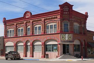
Ellsworth is a city in and the county seat of Ellsworth County, Kansas, United States. As of the 2020 census, the population of the city was 3,066. Known as a cow town in the 1870s, when the Kansas Pacific Railroad operated a stockyard here for shipping cattle to eastern markets, in the 21st century, it serves as the trading center of the rural county.

<span class="mw-page-title-main">Alton, Kansas</span> City in Osborne County, Kansas

Alton is a city in Osborne County, Kansas, United States. As of the 2020 census, the population of the city was 100.

<span class="mw-page-title-main">Climate of Missouri</span> Overview of the climate of Missouri, United States

Missouri generally has a variety of seasonal humid subtropical climate, with cool winters and long, hot summers. In the southern part of the state, particularly in the Bootheel, the climate borders on a more mild-type humid subtropical climate, and in the northern third, the state transitions into a humid continental climate. Because of its location in the interior United States, Missouri often experiences extremes in temperatures. Lacking either large mountains or oceans nearby to moderate its temperature, its climate is alternately influenced by air from the cold Arctic and the hot and humid Gulf of Mexico.

<span class="mw-page-title-main">Embarrass, Minnesota</span> Unincorporated community in Minnesota, United States

Embarrass is an unincorporated community in Embarrass Township, Saint Louis County, Minnesota, United States.

<span class="mw-page-title-main">1936 North American heat wave</span> Extreme weather event

The 1936 North American heat wave was one of the most severe heat waves in the modern history of North America. It took place in the middle of the Great Depression and Dust Bowl of the 1930s and caused catastrophic human suffering and an enormous economic toll. The death toll exceeded 5,000, and huge numbers of crops were destroyed by the heat and lack of moisture. Many state and city record high temperatures set during the 1936 heat wave stood until the summer 2012 North American heat wave. Many more endure to this day; as of 2022, 13 state record high temperatures were set in 1936. The 1936 heat wave followed one of the coldest winters on record.

<span class="mw-page-title-main">Climate of California</span> Overview of the climate of the U.S. state of California

The climate of California varies widely from hot desert to alpine tundra, depending on latitude, elevation, and proximity to the Pacific Coast. California's coastal regions, the Sierra Nevada foothills, and much of the Central Valley have a Mediterranean climate, with warmer, drier weather in summer and cooler, wetter weather in winter. The influence of the ocean generally moderates temperature extremes, creating warmer winters and substantially cooler summers in coastal areas.

Columbus, Ohio has a humid continental climate, characterized by humid, hot summers and cold winters, with no dry season. The Dfa climate has average temperatures above 22 °C during the warmest months, with at least four months averaging above 10 °C, and below 0 °C during the coldest. The climate is transitional with the Cfa humid subtropical climate to the south, characterized by humid, hot summers and cool winters.

<span class="mw-page-title-main">Climate of North Dakota</span>

North Dakota's climate is typical of a continental climate with cold winters and warm-hot summers. The state's location in the Upper Midwest allows it to experience some of the widest variety of weather in the United States, and each of the four seasons has its own distinct characteristics. The eastern half of the state has a humid continental climate with warm to hot, somewhat humid summers and cold, windy winters, while the western half has a semi-arid climate with less precipitation and less humidity but similar temperature profiles. The areas east of the Missouri River get slightly colder winters, while those west of the stream get higher summer daytime temperatures. In general, the diurnal temperature difference is prone to be more significant in the west due to higher elevation and less humidity.

<span class="mw-page-title-main">Climate of Georgia (U.S. state)</span> Overview of the climate of the U.S. state of Georgia

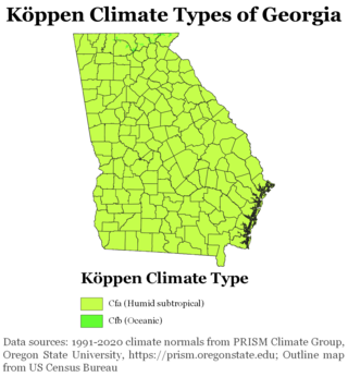
The climate of Georgia is a humid subtropical climate, with most of the state having short, mild winters and long, hot summers. The Atlantic Ocean on the east coast of Georgia and the hill country in the north impact the state's climate. Also, the Chattahoochee River divides Georgia into separate climatic regions with the mountain region to the northwest being cooler than the rest of the state; the average temperatures for the mountain region in January and July are 39 °F (4 °C) and 78 °F (26 °C) respectively. Winter in Georgia is characterized by mild temperatures and little snowfall around the state, with the potential for snow and ice increasing in the northern parts of the state. Summer daytime temperatures in Georgia often exceed 95 °F (35 °C). The state experiences widespread precipitation. Tornadoes and tropical cyclones are common.

<span class="mw-page-title-main">Climate of Pennsylvania</span> Overview of the climate of the U.S. state of Pennsylvania

The climate of Pennsylvania is diverse due to the multitude of geographic features found within the state. Straddling two major climate zones, the southeastern corner of Pennsylvania has the warmest climate. A portion of Greater Philadelphia lies at the southernmost tip of the humid continental climate zone, with the city proper being in the humid subtropical climate zone. Still, Philadelphia features colder, snowier winters than most locations with a humid subtropical climate. Moving west toward the mountainous interior of the state, the climate becomes markedly colder, the number of cloudy days increases, and winter snowfall amounts are greater.

<span class="mw-page-title-main">Geography of Oklahoma</span> Oklahoma Geography

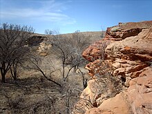
The Geography of Oklahoma encompasses terrain and ecosystems ranging from arid plains to subtropical forests and mountains. Oklahoma contains 10 distinct ecological regions, more per square mile than in any other state by a wide margin. It is situated in the Great Plains and U.S. Interior Highlands region near the geographical center of the 48 contiguous states. Usually considered part of the South Central United States, Oklahoma is bounded on the east by Arkansas and Missouri, on the north by Kansas, on the northwest by Colorado, on the far west by New Mexico, and on the south and near-west by Texas.

<span class="mw-page-title-main">Geography of Kentucky</span> Overview of the Geography of Kentucky

Kentucky is situated in the Upland South region of the United States. A significant portion of eastern Kentucky is part of Appalachia.

<span class="mw-page-title-main">Geography of Connecticut</span> Overview of the Geography of Connecticut

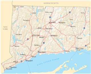
The U.S. state of Connecticut is bordered on the south by Long Island Sound, on the west by New York, on the north by Massachusetts, and on the east by Rhode Island. The state capital and fourth largest city is Hartford, and other major cities and towns include Bridgeport, New Haven, Stamford, Waterbury, Norwalk, Danbury, New Britain, Greenwich, and Bristol. There are 169 incorporated towns in Connecticut, with cities and villages included within some towns.

<span class="mw-page-title-main">Climate of New York (state)</span> Overview of the climate of the U.S. state of New York

The climate of New York (state) is generally humid continental, while the extreme southeastern portion of the state lies in the warmer humid subtropical climate zone. Winter temperatures average below freezing during January and February in much of the state of New York, but several degrees above freezing along the Atlantic coastline, including New York City.

<span class="mw-page-title-main">Climate of Massachusetts</span> Overview of the climate of Massachusetts

The climate of Massachusetts' is mainly a humid continental climate, with hot, humid summers, cold, snowy winters and abundant precipitation. Massachusetts is a states located in the New England region of the northeastern United States. Most of its population of 7.;million live in the Boston metropolitan area. The eastern half of this relatively small state is mostly urban and suburban. Massachusetts is the most populous of the six New England states and ranks third in the nation by population density and fourth by GDP per capita. Massachusetts receives about 43 inches or 1,090 millimetres of rain annually, fairly evenly distributed throughout the years, slightly wetter during the winter. Summers are warm with average high temperatures in July above 80 °F or 26.7 °C and overnight lows above 60 °F or 15.6 °C common throughout the state. Winters are cold, but generally less extreme on the coast with high temperatures in the winter averaging above freezing even in January, although areas further inland are much colder. The state does have extreme temperatures from time to time with 100 °F or 37.8 °C in the summer and temperatures below 0 °F or −17.8 °C in the winter not being unusual.

<span class="mw-page-title-main">Climate of New Jersey</span> Overview of the climate of the U.S. state of New Jersey

The climate of New Jersey classification of the U.S. state of New Jersey is humid subtropical in South Jersey with a humid continental climate in North Jersey, particularly in the northwestern area of the state. The northwest part of New Jersey is the snowiest due to the higher elevations that earn it a Dfb classification. During the winters, New Jersey can experience Nor'easters, which are snowstorms that affect the Northeastern United States, and Atlantic Canada. However, many would-be snow events in the state end up turning to rain due to warm ocean air being brought in by the storm. New Jersey's climate is shaped by its proximity to the Atlantic Ocean which provides moisture and moderates temperatures. According to climatology research by the U.S. National Oceanic and Atmospheric Administration, New Jersey has been the fastest-warming state by average air temperature over a 100-year period beginning in the early 20th century, related to global warming.

<span class="mw-page-title-main">Climate of New England</span> Overview of the climate of New England

The climate of New England varies greatly across its 500-mile (800 km) span from northern Maine to southern Connecticut.

References

  1. "Kansas Land Area County Rank". www.usa.com.
  2. Adams, George Irving. 1903. The physiographic divisions of Kansas. Transactions of the Kansas Academy of Science 18:109-123.
  3. "Physiographic Regions". Kansas Geological Survey (KGS) at University of Kansas (KU). Archived from the original on October 6, 2021.
  4. "Kansas Is Flatter Than a Pancake". Improbable.com. Archived from the original on July 30, 2010. Retrieved July 31, 2010.
  5. "Highest, Lowest, and Mean Elevations in the United States". infoplease.com. Retrieved May 20, 2018.
  6. "Fracas over Kansas pancake flap". Geotimes.org. Archived from the original on January 24, 2004. Retrieved July 31, 2010.
  7. "Kansas". National Park Service. Archived from the original on December 17, 2006. Retrieved July 15, 2008.
  8. "Kansas Natural Heritage Inventory: Rare plants and animals, and natural communities". Kansas Biological Survey. February 12, 2013. Retrieved March 16, 2021.
  9. Kansas, Natural Heritage Inventory (January 9, 2014). "Rare Vertebrates Kansas" (PDF). Archived from the original (PDF) on May 10, 2022. Retrieved October 19, 2022.
  10. Kansas, Natural Heritage Inventory (January 9, 2014). "Rare Vertebrates of Kansas" (PDF). Archived from the original (PDF) on May 10, 2022. Retrieved October 19, 2022.
  11. K-State Research, and Extension. "Native Plants" (PDF). www.johnson.k-state.edu.
  12. "Kansas Wildflowers and Grasses". www.kswildflower.org. Retrieved March 16, 2021.
  13. "Annual Average Number of Tornadoes, 1953–2004". National Climatic Data Center. Archived from the original on October 16, 2011. Retrieved October 25, 2006.
  14. "Records for the State of Kansas". National Weather Service Weather Forecast Office – Wichita, KS. NOAA. Retrieved January 31, 2012.
  15. "Record Highest Temperatures by State (through 2003)" (PDF). NOAA.gov. NOAA. Retrieved January 31, 2012.
  16. National Oceanic and Atmospheric Administration; ‘Monthly State Maximum/Minimum Extremes’
  17. Team, National Weather Service Corporate Image Web. "National Weather Service Climate". www.nws.noaa.gov. Retrieved 2020-08-07.
  18. "Station Name: KS TOPEKA MUNI AP". National Oceanic and Atmospheric Administration. Retrieved 2020-07-12.
  19. "WMO Climate Normals for TOPEKA/MUNICIPAL ARPT KS 1961–1990". National Oceanic and Atmospheric Administration. Retrieved 2014-03-11.
  20. "NOWData - NOAA Online Weather Data". National Weather Service Forecast Office - Wichita, KS. Retrieved 2021-10-13.
  21. "Summary of Monthly Normals 1991-2020". National Oceanic and Atmospheric Administration . Retrieved 2021-10-13.
  22. "WMO Climate Normals for WICHITA/MID-CONTINENT ARPT KS 1961–1990". National Oceanic and Atmospheric Administration. Retrieved March 11, 2014.
  23. "NOWData – NOAA Online Weather Data". Dodge City, Kansas: National Weather Service Forecast Office. Retrieved August 8, 2020.
  24. "Station Name: KS DODGE CITY". National Oceanic and Atmospheric Administration. Retrieved March 26, 2014.
  25. "WMO Climate Normals for DODGE CITY/MUNICIPAL, KS 1961–1990". National Oceanic and Atmospheric Administration. Retrieved March 11, 2014.
  1. 1981−2010 normals, extremes 1887−present. Official records for Topeka kept at the Weather Bureau Office from June 1887 to July 1946, and at Philip Billard Municipal Airport since August 1946. For more information, see Threadex
  2. 1981–2010 normals. Mean monthly maxima and minima (i.e. the expected highest and lowest temperature readings at any point during the year or given month) calculated based on data at said location from 1981 to 2010. Extremes 1874-present.