Wallace County, Kansas

Last updated

Wallace County
Wallace County, Kansas courthouse from S 1.JPG
Wallace County Courthouse in Sharon Springs (2010)
Map of Kansas highlighting Wallace County.svg
Location within the U.S. state of Kansas
Kansas in United States.svg
Kansas's location within the U.S.
Coordinates: 38°45′52″N101°34′33″W / 38.7644°N 101.5758°W / 38.7644; -101.5758
CountryFlag of the United States.svg United States
StateFlag of Kansas.svg  Kansas
Founded1868
Named for W. H. L. Wallace
Seat Sharon Springs
Largest citySharon Springs
Area
  Total914 sq mi (2,370 km2)
  Land914 sq mi (2,370 km2)
  Water0.05 sq mi (0.1 km2)  0.01%
Population
 (2020) [1]
  Total1,512
  Estimate 
(2021) [2]
1,508 Decrease2.svg
  Density1.7/sq mi (0.7/km2)
Time zone UTC−7 (Mountain)
  Summer (DST) UTC−6 (MDT)
Congressional district 1st
Website wallacecountyks.gov

Wallace County is a county located in the U.S. state of Kansas. Its county seat is Sharon Springs. [3] As of the 2020 census, the county population was 1,512, [1] making it the second-least populous county in Kansas (Greeley County is the least). The county was created in 1868 and named in honor of Brigadier General W.H.L. Wallace, who had been mortally wounded in combat in the Battle of Shiloh. Wallace County is home to Mount Sunflower, the highest point in Kansas at 4,039 feet (1,231 meters). Mount Sunflower is located approximately 15 miles (24 km) north-northwest of Weskan, less than one mile (1.6 km) from the Colorado state line. It is one of four Kansas counties to use the Mountain Time Zone rather than the Central Time Zone like the remainder of Kansas.

Contents

History

Early history

For many millennia, the Great Plains of North America was inhabited by nomadic Native Americans. From the 16th century to 18th century, the Kingdom of France claimed ownership of large parts of North America. In 1762, after the French and Indian War, France secretly ceded New France to Spain, per the Treaty of Fontainebleau.

19th century

In 1802, Spain returned most of the land to France, but keeping title to about 7,500 square miles. In 1803, most of the land for modern day Kansas was acquired by the United States from France as part of the 828,000 square mile Louisiana Purchase for 2.83 cents per acre.

In 1854, the Kansas Territory was organized, then in 1861 Kansas became the 34th U.S. state. In 1868, Wallace County was established.

Geography

According to the United States Census Bureau, the county has a total area of 914 square miles (2,370 km2), of which 914 square miles (2,370 km2) is land and 0.05 square miles (0.13 km2) (0.01%) is water. [4]

Adjacent counties

Demographics

Population pyramid based on 2000 census age data USA Wallace County, Kansas age pyramid.svg
Population pyramid based on 2000 census age data
Historical population
CensusPop.Note
1870 538
1880 68627.5%
1890 2,468259.8%
1900 1,178−52.3%
1910 2,759134.2%
1920 2,424−12.1%
1930 2,88218.9%
1940 2,216−23.1%
1950 2,50813.2%
1960 2,069−17.5%
1970 2,2157.1%
1980 2,045−7.7%
1990 1,821−11.0%
2000 1,749−4.0%
2010 1,485−15.1%
2020 1,5121.8%
2023 (est.)1,509 [5] −0.2%
U.S. Decennial Census [6]
1790-1960 [7] 1900-1990 [8]
1990-2000 [9] 2010-2020 [1]

As of the census of 2000, there were 1,749 people, 674 households, and 477 families residing in the county. The population density was 2 people per square mile (0.77 people/km2). There were 791 housing units at an average density of 1 per square mile (0.39/km2). The racial makeup of the county was 94.63% White, 0.63% Black or African American, 0.80% Native American, 0.17% Asian, 2.52% from other races, and 1.26% from two or more races. 4.80% of the population were Hispanic or Latino of any race.

There were 674 households, out of which 33.80% had children under the age of 18 living with them, 63.60% were married couples living together, 4.00% had a female householder with no husband present, and 29.20% were non-families. 27.60% of all households were made up of individuals, and 13.60% had someone living alone who was 65 years of age or older. The average household size was 2.56 and the average family size was 3.12.

In the county, the population was spread out, with 29.10% under the age of 18, 6.50% from 18 to 24, 23.60% from 25 to 44, 22.80% from 45 to 64, and 18.10% who were 65 years of age or older. The median age was 40 years. For every 100 females there were 99.00 males. For every 100 females age 18 and over, there were 99.40 males.

The median income for a household in the county was $33,000, and the median income for a family was $42,022. Males had a median income of $25,610 versus $18,333 for females. The per capita income for the county was $17,016. About 10.70% of families and 16.10% of the population were below the poverty line, including 24.50% of those under age 18 and 12.70% of those age 65 or over.

Government

Presidential elections

Presidential election results
United States presidential election results for Wallace County, Kansas [10]
Year Republican Democratic Third party
No.%No.%No.%
2020 77093.33%445.33%111.33%
2016 72190.35%465.76%313.88%
2012 71990.10%688.52%111.38%
2008 69085.82%9611.94%182.24%
2004 74284.70%11212.79%222.51%
2000 73785.60%10311.96%212.44%
1996 73876.24%16016.53%707.23%
1992 67963.70%16415.38%22320.92%
1988 65569.61%25727.31%293.08%
1984 83882.97%15215.05%201.98%
1980 81178.28%16716.12%585.60%
1976 60052.77%48642.74%514.49%
1972 78273.22%21420.04%726.74%
1968 60861.54%23523.79%14514.68%
1964 51650.69%49648.72%60.59%
1960 72768.20%33931.80%00.00%
1956 68472.69%25126.67%60.64%
1952 94578.82%24920.77%50.42%
1948 63758.23%43940.13%181.65%
1944 72070.80%29228.71%50.49%
1940 75667.08%36132.03%100.89%
1936 65856.68%49242.38%110.95%
1932 56140.27%76154.63%715.10%
1928 73866.19%35631.93%211.88%
1924 60353.70%17115.23%34931.08%
1920 63270.38%20322.61%637.02%
1916 38139.48%49751.50%879.02%
1912 8115.17%15228.46%30156.37%
1908 35059.32%20634.92%345.76%
1904 27883.99%3911.78%144.23%
1900 21266.25%10231.88%61.88%
1896 18159.34%12440.66%00.00%
1892 37755.93%00.00%29744.07%
1888 41265.71%19831.58%172.71%

Wallace has long been one of the most overwhelmingly Republican of all the state's counties. Only two Democratic presidential nominees have ever won Wallace County – Woodrow Wilson in 1916 and Franklin D. Roosevelt in 1932. Since 1944 only three Democratic presidential candidates have won 31 percent of Wallace County's vote – Harry S. Truman in 1948, Lyndon Johnson in 1964 and Jimmy Carter in 1976 – whilst since 1980 only Michael Dukakis during the drought-affected 1988 election has obtained so much as seventeen percent for the Democratic Party. Indeed, in the 2016 election Hillary Clinton recorded less than six percent of the county's vote, whilst the last six Republican nominees have all exceeded 80 percent. In the 2012, 2016, and 2020 elections, Wallace was the only county in Kansas to give over 90% of the vote to the Republican nominee, namely Mitt Romney followed by Donald Trump.

Laws

Although the Kansas Constitution was amended in 1986 to allow the sale of alcoholic liquor by the individual drink with the approval of voters, Wallace County has remained a prohibition, or "dry", county, the only such county remaining in the state as of March 2023. [11]

Education

Unified school districts

Communities

2005 map of Wallace County (legend) Map of Wallace Co, Ks, USA.png
2005 map of Wallace County (legend)
"Mount Sunflower," the highest point in Kansas, is located in Wallace County Mount Sunflower KS Summit.jpg
"Mount Sunflower," the highest point in Kansas, is located in Wallace County

List of townships / incorporated cities / unincorporated communities / extinct former communities within Wallace County. [12]
† means a community is designated a Census-Designated Place (CDP) by the United States Census Bureau.

Cities

Unincorporated communities

Townships

Wallace County is divided into four townships. None of the cities within the county are considered governmentally independent, and all figures for the townships include those of the cities. In the following table, the population center is the largest city (or cities) included in that township's population total, if it is of a significant size.

Sources: 2000 U.S. Gazetteer from the U.S. Census Bureau.
Township FIPS Population
center
PopulationPopulation
density
/km2 (/sq mi)
Land area
km2 (sq mi)
Water area
km2 (sq mi)
Water %Geographic coordinates
Harrison30450850 (1)210 (81)0 (0)0% 38°45′53″N101°34′34″W / 38.76472°N 101.57611°W / 38.76472; -101.57611
Sharon Springs64400 Sharon Springs 1,0961 (3)885 (342)0 (0)0% 38°54′12″N101°45′3″W / 38.90333°N 101.75083°W / 38.90333; -101.75083
Wallace74775Wallace1750 (1)488 (188)0 (0)0.01% 38°58′15″N101°33′35″W / 38.97083°N 101.55972°W / 38.97083; -101.55972
Weskan76700Weskan3931 (1)784 (303)0 (0)0.01% 38°53′8″N101°56′10″W / 38.88556°N 101.93611°W / 38.88556; -101.93611

See also

Community information for Kansas

Related Research Articles

<span class="mw-page-title-main">Wichita County, Kansas</span> County in Kansas, United States

Wichita County is a county located in the U.S. state of Kansas. Its county seat is Leoti. As of the 2020 census, the county population was 2,152. The county was named after the Wichita tribe.

<span class="mw-page-title-main">Washington County, Kansas</span> County in Kansas, United States

Washington County is a county located in the U.S. state of Kansas. Its county seat and largest city is Washington. As of the 2020 census, the county population was 5,530. The county was named for George Washington, the 1st president of the United States.

<span class="mw-page-title-main">Trego County, Kansas</span> County in Kansas, United States

Trego County is a county located in the U.S. state of Kansas. Its county seat and largest city is WaKeeney. As of the 2020 census, the county population was 2,808. The county was named for Edgar Trego.

<span class="mw-page-title-main">Smith County, Kansas</span> County in Kansas, United States

Smith County is a county located in the U.S. state of Kansas. Its county seat is Smith Center. As of the 2020 census, the population was 3,570. The county is named in memory of J. Nelson Smith, a major in the 2nd Colorado Cavalry, killed at the Battle of Westport on October 21, 1864. The geographic center of the contiguous United States is located within the county, near Lebanon.

<span class="mw-page-title-main">Sherman County, Kansas</span> County in Kansas, United States

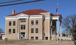
Sherman County is a county located in the U.S. state of Kansas. Its county seat is Goodland. As of the 2020 census, the county population was 5,927. Sherman County was created by the Legislature of 1873, and named after general William Sherman, a general during the American Civil War.

<span class="mw-page-title-main">Sheridan County, Kansas</span> County in Kansas, United States

Sheridan County is a county located in the U.S. state of Kansas. Its county seat is Hoxie. As of the 2020 census, the county population was 2,447. The county was named in honor of Phillip Sheridan, a general during the American Civil War.

<span class="mw-page-title-main">Rawlins County, Kansas</span> County in Kansas, United States

Rawlins County is a county located in the U.S. state of Kansas. Its county seat and largest city is Atwood. As of the 2020 census, the county population was 2,561. It was named after John Rawlins, a general in the American Civil War.

<span class="mw-page-title-main">Phillips County, Kansas</span> County in Kansas, United States

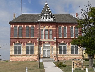
Phillips County is a county located in the U.S. state of Kansas. Its county seat and largest city is Phillipsburg. As of the 2020 census, the county population was 4,981. The county was named after William Phillips, a free-state abolition journalist and colonel in the American Civil War.

<span class="mw-page-title-main">Ottawa County, Kansas</span> County in Kansas, United States

Ottawa County is a county located in the U.S. state of Kansas. Its county seat and largest city is Minneapolis. As of the 2020 census, the county population was 5,735. The county was named after the Odawa tribe.

<span class="mw-page-title-main">Neosho County, Kansas</span> County in Kansas, United States

Neosho County is a county located in Southeast Kansas. Its county seat is Erie. As of the 2020 census, the county population was 15,904. The county was named for the Neosho River, which passes through the county.

<span class="mw-page-title-main">Logan County, Kansas</span> County in Kansas, United States

Logan County is a county located in the U.S. state of Kansas. Its county seat and largest city is Oakley. As of the 2020 census, the county population was 2,762. The county was named for John Logan, a general during the American Civil War. One of the county's distinctive features is a mile-long stretch of Smoky Hill Chalk bluffs that tower 100 feet (30 m) high over the Smoky Hill River and are dubbed "Little Jerusalem" for resemblance to the ancient walled city. The formation is mostly on private land. In 2016, The Nature Conservancy purchased the property and the Little Jerusalem Badlands State Park opened to the public in October 2019.

<span class="mw-page-title-main">Linn County, Kansas</span> County in Kansas, United States

Linn County is a county in the U.S. state of Kansas, located in along the eastern edge of Kansas, and is part of the Kansas City metropolitan area. Its county seat is Mound City, and its most populous city is Pleasanton. As of the 2020 census, the county population was 9,591. The county was named for Lewis Linn, a U.S. Senator from Missouri.

<span class="mw-page-title-main">Kiowa County, Kansas</span> County in Kansas, United States

Kiowa County is a county located in the U.S. state of Kansas. Its county seat and largest city is Greensburg. As of the 2020 census, the county population was 2,460. The county is named after the Kiowa tribe.

<span class="mw-page-title-main">Kingman County, Kansas</span> County in Kansas, United States

Kingman County is a county located in the U.S. state of Kansas. Its county seat and largest city is Kingman. As of the 2020 census, the county population was 7,470. The county was named for Samuel Kingman, a chief justice of the Kansas Supreme Court during the 1860s and 1870s.

<span class="mw-page-title-main">Kearny County, Kansas</span> County in Kansas, United States

Kearny County is a county located in the U.S. state of Kansas. Its county seat and most populous city is Lakin. As of the 2020 census, the county population was 3,983. The county is named in honor of Philip Kearny, a general during the American Civil War that died during the Battle of Chantilly.

<span class="mw-page-title-main">Jewell County, Kansas</span> County in Kansas, United States

Jewell County is a county located in the U.S. state of Kansas. Its county seat and most populous city is Mankato. As of the 2020 census, the county population was 2,932. The county was named for Lewis Jewell, a Lieutenant Colonel of the 6th Regiment Kansas Volunteer Cavalry.

<span class="mw-page-title-main">Greeley County, Kansas</span> County in Kansas, United States

Greeley County is a county located in western Kansas, in the Central United States. Its county seat and largest city is Tribune. As of the 2020 census, the population was 1,284, making it the least populous county in Kansas. As of 2018, it is tied with Wallace County as the least densely populated county in the state. The county is named after Horace Greeley, editor of the New York Tribune, who encouraged western settlement with the motto "Go West, young man".

<span class="mw-page-title-main">Coffey County, Kansas</span> County in Kansas, United States

Coffey County is a county located in Eastern Kansas. Its county seat and most populous city is Burlington. As of the 2020 census, the county population was 8,360. It was named after A.M. Coffey, a territorial legislator and Free-Stater during Bleeding Kansas era.

<span class="mw-page-title-main">Brown County, Kansas</span> County in Kansas, United States

Brown County is a county located in the northeast portion of the U.S. state of Kansas. Its county seat and most populous city is Hiawatha. As of the 2020 census, the county population was 9,508. The county was named after Albert G. Brown, a U.S. Senator from Mississippi and Kansas statehood advocate. The Kickapoo Indian Reservation of Kansas, the majority of the Sac and Fox Reservation, and the majority of the Iowa Reservation of Kansas and Nebraska are located within the county.

<span class="mw-page-title-main">Anderson County, Kansas</span> County in Kansas, United States

Anderson County is a county located in East Central Kansas, in the Central United States. Its county seat and most populous city is Garnett. As of the 2020 census, the county population was 7,836. The county was named for Joseph C. Anderson, a Kansas territorial legislator and border ruffian during the "Bleeding Kansas" era.

References

  1. 1 2 3 "QuickFacts; Wallace County, Kansas; Population, Census, 2020 & 2010". United States Census Bureau. Archived from the original on August 22, 2021. Retrieved August 21, 2021.
  2. "Annual Estimates of the Resident Population for Counties: April 1, 2020 to July 1, 2021" . Retrieved October 23, 2022.
  3. "Find a County". National Association of Counties. Retrieved June 7, 2011.
  4. "US Gazetteer files: 2010, 2000, and 1990". United States Census Bureau. February 12, 2011. Retrieved April 23, 2011.
  5. "Annual Estimates of the Resident Population for Counties: April 1, 2020 to July 1, 2023". United States Census Bureau. Retrieved April 3, 2024.
  6. "U.S. Decennial Census". United States Census Bureau. Retrieved July 29, 2014.
  7. "Historical Census Browser". University of Virginia Library. Retrieved July 29, 2014.
  8. "Population of Counties by Decennial Census: 1900 to 1990". United States Census Bureau. Retrieved July 29, 2014.
  9. "Census 2000 PHC-T-4. Ranking Tables for Counties: 1990 and 2000" (PDF). United States Census Bureau. Archived (PDF) from the original on March 27, 2010. Retrieved July 29, 2014.
  10. "Dave Leip's Atlas of U.S. Presidential Elections".
  11. "Map of Wet and Dry Counties" (PDF). Kansas Department of Revenue Alcoholic Beverage Control. March 1, 2023. Archived (PDF) from the original on October 7, 2023. Retrieved December 4, 2023.
  12. 1 2 "General Highway Map of Wallace County, Kansas" (PDF). Kansas Department of Transportation (KDOT). July 2010. Archived (PDF) from the original on July 23, 2023.

Further reading

County
Maps

38°55′N101°46′W / 38.917°N 101.767°W / 38.917; -101.767