Harvey County | |
---|---|
Coordinates: 38°03′N97°26′W / 38.050°N 97.433°W | |
Country | United States |
State | Kansas |
Founded | March 7, 1872 |
Named for | James Harvey |
Seat | Newton |
Largest city | Newton |
Area | |
• Total | 541 sq mi (1,400 km2) |
• Land | 540 sq mi (1,400 km2) |
Population | |
• Total | 34,024 |
• Density | 63.0/sq mi (24.3/km2) |
Time zone | UTC−6 (Central) |
• Summer (DST) | UTC−5 (CDT) |
Congressional district | 4th |
Website | harveycounty.com |
Harvey County is a county located in the U.S. state of Kansas. Its county seat and most populous city is Newton. [2] As of the 2020 census, the county population was 34,024. [1] The county was named for James Harvey, a U.S. senator and 5th governor of Kansas.
In 1854, the Kansas Territory was organized, then in 1861 Kansas became the 34th U.S. state.
In 1871, the Atchison, Topeka and Santa Fe Railway extended a main line from Emporia to Newton. [3]
In 1872, Harvey County was founded, and named in honor of the fifth Governor of Kansas James M. Harvey. [4]
According to the U.S. Census Bureau, the county has a total area of 541 square miles (1,400 km2), of which 540 square miles (1,400 km2) is land and 1.0 square mile (2.6 km2) (0.2%) is water. [5] The Little Arkansas River flows through the county.
Census | Pop. | Note | %± |
---|---|---|---|
1880 | 11,451 | — | |
1890 | 17,601 | 53.7% | |
1900 | 17,591 | −0.1% | |
1910 | 19,200 | 9.1% | |
1920 | 20,744 | 8.0% | |
1930 | 22,120 | 6.6% | |
1940 | 21,712 | −1.8% | |
1950 | 21,698 | −0.1% | |
1960 | 25,865 | 19.2% | |
1970 | 27,236 | 5.3% | |
1980 | 30,531 | 12.1% | |
1990 | 31,028 | 1.6% | |
2000 | 32,869 | 5.9% | |
2010 | 34,684 | 5.5% | |
2020 | 34,024 | −1.9% | |
2023 (est.) | 33,504 | [6] | −1.5% |
U.S. Decennial Census [7] 1790-1960 [8] 1900-1990 [9] 1990-2000 [10] 2010-2020 [1] |
Harvey County is part of the Wichita, KS Metropolitan Statistical Area.
As of the 2000 census, [11] there were 32,869 people, 12,581 households, and 8,932 families residing in the county. The population density was 61 inhabitants per square mile (24/km2). There were 13,378 housing units at an average density of 25 per square mile (9.7/km2). The racial makeup of the county was 91.04% White, 1.59% Black or African American, 0.52% Native American, 0.52% Asian, 0.03% Pacific Islander, 4.17% from other races, and 2.14% from two or more races. Hispanic or Latino of any race were 7.97% of the population.
There were 12,581 households, out of which 32.80% had children under the age of 18 living with them, 60.20% were married couples living together, 7.70% had a female householder with no husband present, and 29.00% were non-families. 25.80% of all households were made up of individuals, and 11.60% had someone living alone who was 65 years of age or older. The average household size was 2.50 and the average family size was 3.00.
In the county, the population was spread out, with 26.00% under the age of 18, 9.10% from 18 to 24, 26.50% from 25 to 44, 21.60% from 45 to 64, and 16.80% who were 65 years of age or older. The median age was 38 years. For every 100 females, there were 94.50 males. For every 100 females age 18 and over, there were 91.60 males.
The median income for a household in the county was $40,907, and the median income for a family was $48,793. Males had a median income of $35,037 versus $22,492 for females. The per capita income for the county was $18,715. About 4.20% of families and 6.40% of the population were below the poverty line, including 7.50% of those under age 18 and 5.00% of those age 65 or over.
Year | Republican | Democratic | Third party | |||
---|---|---|---|---|---|---|
No. | % | No. | % | No. | % | |
2020 | 10,182 | 58.52% | 6,747 | 38.78% | 470 | 2.70% |
2016 | 8,668 | 57.34% | 5,068 | 33.53% | 1,380 | 9.13% |
2012 | 8,588 | 60.08% | 5,373 | 37.59% | 333 | 2.33% |
2008 | 9,006 | 57.40% | 6,318 | 40.27% | 367 | 2.34% |
2004 | 9,534 | 63.10% | 5,331 | 35.28% | 245 | 1.62% |
2000 | 8,271 | 60.44% | 4,591 | 33.55% | 822 | 6.01% |
1996 | 8,382 | 57.79% | 4,918 | 33.91% | 1,204 | 8.30% |
1992 | 6,259 | 41.71% | 5,047 | 33.63% | 3,700 | 24.66% |
1988 | 6,893 | 54.23% | 5,503 | 43.29% | 315 | 2.48% |
1984 | 8,507 | 64.06% | 4,599 | 34.63% | 174 | 1.31% |
1980 | 7,045 | 54.56% | 4,173 | 32.32% | 1,694 | 13.12% |
1976 | 6,624 | 51.00% | 6,003 | 46.22% | 360 | 2.77% |
1972 | 8,287 | 67.23% | 3,555 | 28.84% | 485 | 3.93% |
1968 | 6,682 | 61.64% | 3,351 | 30.91% | 808 | 7.45% |
1964 | 4,979 | 47.81% | 5,306 | 50.95% | 130 | 1.25% |
1960 | 7,798 | 68.38% | 3,537 | 31.02% | 69 | 0.61% |
1956 | 7,367 | 70.20% | 3,084 | 29.39% | 43 | 0.41% |
1952 | 7,154 | 70.87% | 2,726 | 27.00% | 215 | 2.13% |
1948 | 5,270 | 57.72% | 3,615 | 39.59% | 245 | 2.68% |
1944 | 5,339 | 61.35% | 3,300 | 37.92% | 64 | 0.74% |
1940 | 5,539 | 56.76% | 4,087 | 41.88% | 133 | 1.36% |
1936 | 4,456 | 45.28% | 5,357 | 54.44% | 28 | 0.28% |
1932 | 4,192 | 49.28% | 4,091 | 48.09% | 224 | 2.63% |
1928 | 6,330 | 77.62% | 1,748 | 21.43% | 77 | 0.94% |
1924 | 4,499 | 58.96% | 1,744 | 22.86% | 1,387 | 18.18% |
1920 | 4,454 | 63.09% | 2,457 | 34.80% | 149 | 2.11% |
1916 | 3,479 | 48.98% | 3,131 | 44.08% | 493 | 6.94% |
1912 | 703 | 17.70% | 1,499 | 37.74% | 1,770 | 44.56% |
1908 | 2,305 | 58.30% | 1,475 | 37.30% | 174 | 4.40% |
1904 | 2,362 | 70.66% | 690 | 20.64% | 291 | 8.70% |
1900 | 2,266 | 56.65% | 1,658 | 41.45% | 76 | 1.90% |
1896 | 2,082 | 54.57% | 1,678 | 43.98% | 55 | 1.44% |
1892 | 2,025 | 52.80% | 0 | 0.00% | 1,810 | 47.20% |
1888 | 2,145 | 54.25% | 1,065 | 26.93% | 744 | 18.82% |
Following amendment to the Kansas Constitution in 1986, the county remained a prohibition, or "dry", county until 1996, when voters approved the sale of alcoholic liquor by the individual drink with a 30% food sales requirement. [13]
The county voted "No" on the 2022 Kansas Value Them Both Amendment, an anti-abortion ballot measure, by 53% to 47% despite backing Donald Trump with 59% of the vote to Joe Biden's 39% in the 2020 presidential election. [14]
List of townships / incorporated cities / unincorporated communities / extinct former communities within Harvey County. [15]
‡ means a community has portions in an adjacent county.
Harvey County is divided into fifteen townships. The cities of Halstead and Newton are considered governmentally independent and are excluded from the census figures for the townships. In the following table, the population center is the largest city (or cities) included in that township's population total, if it is of a significant size.
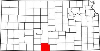
Sumner County is a county located in the U.S. state of Kansas. Its county seat is Wellington. As of the 2020 census, the population was 22,382. The county is named after Charles Sumner, a U.S. Senator from Massachusetts who was a leader of Reconstruction politics.
Smith County is a county located in the U.S. state of Kansas. Its county seat is Smith Center. As of the 2020 census, the population was 3,570. The county is named in memory of J. Nelson Smith, a major in the 2nd Colorado Cavalry, killed at the Battle of Westport on October 21, 1864. The geographic center of the contiguous United States is located within the county, near Lebanon.
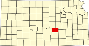
Sedgwick County is located in the U.S. state of Kansas. Its county seat is Wichita, the most populous city in the state. As of the 2020 census, the population was 523,824, making it the second-most populous county in Kansas. The county was named for John Sedgwick, the highest ranking Union general killed during the American Civil War.
Reno County is a county located in the U.S. state of Kansas. Its county seat and largest city is Hutchinson. As of the 2020 census, the population was 61,898. The county is named for Jesse Reno, a general during the American Civil War.
Ness County is a county located in the U.S. state of Kansas. Its county seat and largest city is Ness City. As of the 2020 census, the county population was 2,687. The county was named for Noah Ness, a corporal of the 7th Kansas Cavalry.
Neosho County is a county located in Southeast Kansas. Its county seat is Erie. As of the 2020 census, the county population was 15,904. The county was named for the Neosho River, which passes through the county.
Nemaha County is a county located in the northeastern part of the U.S. state of Kansas. Its county seat is Seneca. As of the 2020 census, the county population was 10,273. The county was named for the Nemaha River.
Marshall County is a county located in the U.S. state of Kansas. Its county seat and largest city is Marysville. As of the 2020 census, the county population was 10,038. The county was named after Frank J. Marshall, a state representative who operated the first ferry over the Big Blue River.
Leavenworth County is located in the U.S. state of Kansas and is part of the Kansas City metropolitan area. Its county seat and most populous city is Leavenworth. As of the 2020 census, the county population was 81,881. The county was named after Henry Leavenworth, a general in the Indian Wars who established Fort Leavenworth.
Kingman County is a county located in the U.S. state of Kansas. Its county seat and largest city is Kingman. As of the 2020 census, the county population was 7,470. The county was named for Samuel Kingman, a chief justice of the Kansas Supreme Court during the 1860s and 1870s.
Gray County is a county located in the U.S. state of Kansas. Its county seat and most populous city is Cimarron. As of the 2020 census, the county population was 5,653. The county was named after Alfred Gray, a 19th century Kansas politician.
Coffey County is a county located in Eastern Kansas. Its county seat and most populous city is Burlington. As of the 2020 census, the county population was 8,360. It was named after A.M. Coffey, a territorial legislator and Free-Stater during Bleeding Kansas era.
Clark County is a county located in the U.S. state of Kansas. Its county seat and most populous city is Ashland. As of the 2020 census, the county population was 1,991. The county was named after Charles Clarke.
Cherokee County is a U.S. county located in Southeast Kansas. Its county seat is Columbus, and its most populous city is Baxter Springs. As of the 2020 census, the county population was 19,362. The county was named for the Cherokee tribe.
Barber County is a county located in the south-central portion of the U.S. state of Kansas. Its county seat and most populous city is Medicine Lodge. As of the 2020 census, the county population was 4,228. The county was named for Thomas Barber, an abolitionist who was killed in Douglas County in 1855 during the Wakarusa War.
Burrton is a city in Harvey County, Kansas, United States. It is named after Isaac T. Burr, former vice-president of the Atchison, Topeka and Santa Fe Railway. As of the 2020 census, the population of the city was 861.
Halstead is a city in Harvey County, Kansas, United States. Halstead was named in honor of Murat Halstead, a respected Civil War correspondent and newspaper editor. As of the 2020 census, the population of the city was 2,179.
Hesston is a city in Harvey County, Kansas, United States. As of the 2020 census, the population of the city was 3,505. Large manufacturing facilities for AGCO and Excel Industries are located in Hesston. It is home of Hesston College.
Sedgwick is a city in Harvey and Sedgwick counties in the State of Kansas. As of the 2020 census, the population of the city was 1,603.
The Wichita, Kansas Metropolitan Statistical Area, as defined by the United States Office of Management and Budget, is an area consisting of four counties in south central Kansas, its only principal city is Wichita and its only central county is Sedgwick County. As of the 2013 American Community Survey, the MSA had a population of 637,989.