Cheyenne County, Kansas

Last updated

Cheyenne County
Cheyenne Co KS Courthouse.JPG
Map of Kansas highlighting Cheyenne County.svg
Location within the U.S. state of Kansas
Kansas in United States.svg
Kansas's location within the U.S.
Coordinates: 39°48′N101°48′W / 39.800°N 101.800°W / 39.800; -101.800
CountryFlag of the United States.svg United States
StateFlag of Kansas.svg  Kansas
FoundedMarch 20, 1873
Named for Cheyenne tribe [1]
Seat St. Francis
Largest citySt. Francis
Area
  Total1,021 sq mi (2,640 km2)
  Land1,020 sq mi (2,600 km2)
  Water1.1 sq mi (3 km2)  0.1%
Population
 (2020) [2]
  Total2,616
  Density2.6/sq mi (1.0/km2)
Time zone UTC−6 (Central)
  Summer (DST) UTC−5 (CDT)
Area code 785
Congressional district 1st
Website cncoks.us

Cheyenne County is a county located in the northwest corner of the U.S. state of Kansas. Its county seat and most populous city is St. Francis. [3] As of the 2020 census, the county population was 2,616. [2] The county was named after the Cheyenne tribe. [1]

Contents

History

19th century

In 1854, the Kansas Territory was organized, then in 1861 Kansas became the 34th U.S. state.

Cheyenne County was established by an act of the state legislature on 1873-03-06, [4] which defined the original borders of the county as:

Commencing where the east line of range 37 west, intersects the fortieth degree of north latitude; thence south with said range line to the first standard parallel; thence west with said parallel to the west line of the State of Kansas; thence north with the state line to the fortieth degree of north latitude; thence east with said parallel to the place of beginning. [1]

The county was surveyed the following year, and its first settlers arrived in 1879. [4]

Early settlement was in and around Wano, the "T" ranch (the county's first cattle ranch) being established 9 miles (14 km) from there in 1876, and Jacob Buck and the families of A. M. Brenaman, L. R. Heaton, a man named Bateman all settling around the area. [4] Brenaman was the first postmaster at Wano post office, established on 1880-08-23. [4] The first storekeepers opened their store the following month, with the first school being Kepferle, and the first school district established on 1881-12-03. [4] A dedicated school building, for 10 pupils, was donated by F. J. Graham and opened on 1882-01-10. [4] By 1886 there were 5 school districts. [5]

The name Wano was an Anglicization by the settlers of the Spanish word "bueno" meaning "good". [6] It was not only the name of the post office but of its first newspaper, the Wano News, also run by Brenaman. [6] Like the county's second newspaper, the Echo, the News was short lived and only had 5 issues. [6] Later newspapers were the Cheyenne County Rustler, established on 1885-07-03 and originally published in Wano and later St Francis; the Frontiersman, the Cheyenne County Democrat, and the Bird City News, all published in Bird City; [4] [5] and the Plaindealer published in St Francis. [7]

Independent county government was finally established in April 1886, by proclamation of Governor John A. Martin in response to a petition from the previous month. [6] The appointed county commissioners were J. M. Ketcham, W. W. McKay and J. F. Murray; with B. W. Knott as the county clerk. [6] Martin originally proclaimed Bird City as the county seat, as an initial temporary arrangement. [6] [8] An election for the county seat and for elected county and township officers was held in May 1886, [9] and Wano was chosen as county seat. [10] However, that first election was tainted by voter fraud and later voided by a judge. [11] The current county seat of St. Francis was eventually chosen by an election in February 1889 [12] and later approved by act of the state legislature on in February 1891. [6]

Geography

According to the U.S. Census Bureau, the county has a total area of 1,021 square miles (2,640 km2), of which 1,020 square miles (2,600 km2) is land and 1.1 square miles (2.8 km2) (0.1%) is water. [13]

Farming and biota

In 1886, 6,890 acres (2,790 ha) of the county was fenced farms and 68,807 acres (27,845 ha) unfenced farmland, comprising 12% of the county. [14] There were 13,413 acres (5,428 ha) of cultivated land, 8,035 acres (3,252 ha) being devoted to corn, then the most lucrative crop, followed by 2,042 acres (826 ha) to sorghum, its second most lucrative, and 480 acres (190 ha) of enclosed prairie land. [14] However, most farmers were livestock farmers. [14]

By 1910, the leading crops were (in descending order of value) wheat, corn, barley, hay, and broomcorn. [1] There was not originally much native timberland in the county. [1]

Geology and hydrolology

The county is crossed by the Republican River, whose tributaries include Bluff Creek, Cherry Creek, Plum Creek, and Hackberry Creek. [1] [14] Other trivers include Little Beaver Creek and a 3 miles (4.8 km) reach of Big Beaver Creek in the south-east corner of the county, and the Arickaree River in the north-west corner. [1] [14]

The soil is mainly sandy, with limited amounts of limestone in some of the streams. [1] [14]

Adjacent counties

Major highways

Sources: National Atlas, [15] U.S. Census Bureau [16]

Time Zones

The county is in the Central Time zone, but is bordered by the Mountain Time Zone in three directions; it is the only county in the United States to have this characteristic. Dundy County, Nebraska to the north, Yuma County, Colorado and Kit Carson County, Colorado to the west, and Sherman County to the south are all located in the Mountain Time Zone. As a result, Rawlins County is Cheyenne County's only neighbor to also observe Central Time.

Demographics

Population pyramid based on 2000 census age data USA Cheyenne County, Kansas age pyramid.svg
Population pyramid based on 2000 census age data
Historical population
CensusPop.Note
1880 37
1890 4,40111,794.6%
1900 2,640−40.0%
1910 4,24860.9%
1920 5,58731.5%
1930 6,94824.4%
1940 6,221−10.5%
1950 5,668−8.9%
1960 4,708−16.9%
1970 4,256−9.6%
1980 3,678−13.6%
1990 3,243−11.8%
2000 3,165−2.4%
2010 2,726−13.9%
2020 2,616−4.0%
2023 (est.)2,636 [17] 0.8%
U.S. Decennial Census [18]
1790–1960 [19] 1900–1990 [20]
1990–2000 [21] 2010–2020 [2]

In 1886 there were 2607 people in the county. [8] By 1910 this had risen to 4248. [1]

As of the 2000 census, [22] there were 3,165 people, 1,360 households, and 919 families residing in the county. The population density was 3 people per square mile (1.2 people/km2). There were 1,636 housing units at an average density of 2 per square mile (0.77/km2). The racial makeup of the county was 97.91% White, 0.13% Black or African American, 0.09% Native American, 0.32% Asian, 0.03% Pacific Islander, 0.98% from other races, and 0.54% from two or more races. Hispanic or Latino of any race were 2.59% of the population.

There were 1,360 households, out of which 27.60% had children under the age of 18 living with them, 60.10% were married couples living together, 5.10% had a female householder with no husband present, and 32.40% were non-families. 30.80% of all households were made up of individuals, and 17.30% had someone living alone who was 65 years of age or older. The average household size was 2.29 and the average family size was 2.85.

In the county, the population was spread out, with 23.80% under the age of 18, 5.10% from 18 to 24, 22.70% from 25 to 44, 21.80% from 45 to 64, and 26.60% who were 65 years of age or older. The median age was 44 years. For every 100 females there were 97.30 males. For every 100 females age 18 and over, there were 92.40 males.

The median income for a household in the county was $30,599, and the median income for a family was $34,816. Males had a median income of $24,976 versus $19,569 for females. The per capita income for the county was $17,862. About 7.40% of families and 9.40% of the population were below the poverty line, including 11.80% of those under age 18 and 6.70% of those age 65 or over.

Government

Presidential elections

Cheyenne County is a Republican stronghold. Only four Republican presidential candidates from 1888 to the present day have failed to carry the county, the most recent of which ironically being Kansas Governor Alf Landon in 1936 as he also failed to win the state's electoral votes.

Presidential election results
United States presidential election results for Cheyenne County, Kansas [23]
Year Republican Democratic Third party
No.%No.%No.%
2020 1,18382.79%22415.68%221.54%
2016 1,17383.37%18112.86%533.77%
2012 1,15981.28%23316.34%342.38%
2008 1,14876.64%32321.56%271.80%
2004 1,35379.96%32018.91%191.12%
2000 1,31275.97%35020.27%653.76%
1996 1,21166.83%42223.29%1799.88%
1992 86349.17%40723.19%48527.64%
1988 1,10563.40%59434.08%442.52%
1984 1,44279.06%35619.52%261.43%
1980 1,33073.89%35819.89%1126.22%
1976 1,00855.84%75841.99%392.16%
1972 1,44075.51%39920.92%683.57%
1968 1,42370.66%41220.46%1798.89%
1964 1,14756.23%88643.43%70.34%
1960 1,62271.42%63628.01%130.57%
1956 1,47968.79%66330.84%80.37%
1952 1,91575.63%59723.58%200.79%
1948 1,21953.51%97842.93%813.56%
1944 1,61067.99%73631.08%220.93%
1940 1,76064.14%97135.39%130.47%
1936 1,24142.43%1,67357.20%110.38%
1932 97934.61%1,71660.66%1344.74%
1928 1,46669.61%58627.83%542.56%
1924 1,11950.38%48521.84%61727.78%
1920 1,07962.41%47127.24%17910.35%
1916 49831.78%78750.22%28218.00%
1912 14015.87%30134.13%44150.00%
1908 48654.30%33937.88%707.82%
1904 44672.88%9615.69%7011.44%
1900 34854.12%28644.48%91.40%
1896 32749.55%32248.79%111.67%
1892 50550.45%00.00%49649.55%
1888 77963.08%42034.01%362.91%

Laws

Following amendment to the Kansas Constitution in 1986, the county remained a prohibition, or "dry", county until 2000, when voters approved the sale of alcoholic liquor by the individual drink with a 30% food sales requirement. [24]

Education

Unified school districts

Communities

2005 map of Cheyenne County (map legend) Map of Cheyenne Co, Ks, USA.png
2005 map of Cheyenne County (map legend)

List of townships / incorporated cities / unincorporated communities / extinct former communities within Cheyenne County. [25]

Cities

Unincorporated communities

Ghost towns

Post offices

In 1886 there were six post offices in the county: Bird City, Calhoun, Lawnridge, Marney, Orlando, and Wano. [5] In 1888, four had been added Clugh, Gurney, Jaqua, and Neville and Wano had become St Francis. [26] By 1910 this had shrunk to just four: Bird City, Jaqua, St. Francis, and Wheeler. [27]

Townships

Cheyenne County is divided into seven townships. None of the cities within the county are considered governmentally independent, and all figures for the township include those of the cities. In the following table, the population center is the largest city (or cities) included in that township's population total, if it is of a significant size.

Township FIPS Population
center
PopulationPopulation
density
/km2 (/sq mi)
Land area
km2 (sq mi)
Water area
km2 (sq mi)
Water %Geographic coordinates
Benkelman 06025570 (1)186 (72)0 (0)0% 39°37′8″N101°54′35″W / 39.61889°N 101.90972°W / 39.61889; -101.90972
Bird City 06850 Bird City 7711 (2)884 (341)0 (0)0.02% 39°45′30″N101°31′41″W / 39.75833°N 101.52806°W / 39.75833; -101.52806
Calhoun 09950570 (1)231 (89)2 (1)0.70% 39°56′8″N101°39′18″W / 39.93556°N 101.65500°W / 39.93556; -101.65500
Cleveland Run 14150670 (1)186 (72)0 (0)0.08% 39°52′35″N101°48′20″W / 39.87639°N 101.80556°W / 39.87639; -101.80556
Jaqua 35025460 (1)124 (48)0 (0)0.01% 39°39′48″N102°1′20″W / 39.66333°N 102.02222°W / 39.66333; -102.02222
Orlando 53050631 (2)93 (36)0 (0)0% 39°45′36″N101°41′0″W / 39.76000°N 101.68333°W / 39.76000; -101.68333
Wano 75375 St. Francis 2,1042 (6)937 (362)0 (0)0.05% 39°45′27″N101°50′4″W / 39.75750°N 101.83444°W / 39.75750; -101.83444
Sources: "Census 2000 U.S. Gazetteer Files". U.S. Census Bureau, Geography Division. Archived from the original on August 2, 2002.

Cheyenne started off in 1883 as a single municipal township attached to Rawlins County for judicial and financial purposes. [6] In the May 1886 election before any county or townships officers had been elected and the county seat had been chosen, there were intended to be three townships: Bird City, Wano, and a township named Hour-glass, dividing up what had by then become three municipal townships although swapping some parts of the municipal townships around for the proposed new townships. [9] [8]

In the end, the county initially had 13 townships: Beaver, Benkelman, Bird City, Calhoun, Cherry Creek, Cleveland Run, Dent, Eureka, Jaqua, Lawn Ridge, Nuttycombe, Orlando, and Wano. [28] [8] At the start of the 20th century, there were 17 townships: the aforementioned 13 plus Alexander, Evergreen, Jefferson, and Porter, all added some time between 1888 and 1890. [1] [29] There since has been some consolidation in the 1970s.

See also

Community information for Kansas

Related Research Articles

<span class="mw-page-title-main">Stevens County, Kansas</span> County in Kansas, United States

Stevens County is a county located in the U.S. state of Kansas. Its county seat is Hugoton. As of the 2020 census, the county population was 5,250. The county is named for Thaddeus Stevens, a Reconstruction era Pennsylvania politician.

<span class="mw-page-title-main">Shawnee County, Kansas</span> County in Kansas, United States

Shawnee County is located in northeast Kansas, in the central United States. Its county seat and most populous city is Topeka, the state capital. As of the 2020 census, the population was 178,909, making it the third-most populous county in Kansas. The county was one of the original 33 counties created by the first territorial legislature in 1855, and it was named for the Shawnee tribe.

<span class="mw-page-title-main">Meade County, Kansas</span> County in Kansas, United States

Meade County is a county located in the U.S. state of Kansas. Its county seat and largest city is Meade. As of the 2020 census, the county population was 4,055. The county was created in 1873 and named in honor of George Meade, a general during the American Civil War.

<span class="mw-page-title-main">Marion County, Kansas</span> County in Kansas, United States

Marion County is a county located in the U.S. state of Kansas. Its county seat is Marion and its most populous city is Hillsboro. As of the 2020 census, the county population was 11,823. The county was named in honor of Francis Marion, a brigadier general of the American Revolutionary War, known as the "Swamp Fox".

<span class="mw-page-title-main">Logan County, Kansas</span> County in Kansas, United States

Logan County is a county located in the U.S. state of Kansas. Its county seat and largest city is Oakley. As of the 2020 census, the county population was 2,762. The county was named for John Logan, a general during the American Civil War. One of the county's distinctive features is a mile-long stretch of Smoky Hill Chalk bluffs that tower 100 feet (30 m) high over the Smoky Hill River and are dubbed "Little Jerusalem" for resemblance to the ancient walled city. The formation is mostly on private land. In 2016, The Nature Conservancy purchased the property and the Little Jerusalem Badlands State Park opened to the public in October 2019.

<span class="mw-page-title-main">Linn County, Kansas</span> County in Kansas, United States

Linn County is a county in the U.S. state of Kansas, located in along the eastern edge of Kansas, and is part of the Kansas City metropolitan area. Its county seat is Mound City, and its most populous city is Pleasanton. As of the 2020 census, the county population was 9,591. The county was named for Lewis Linn, a U.S. Senator from Missouri.

<span class="mw-page-title-main">Hodgeman County, Kansas</span> County in Kansas, United States

Hodgeman County is a county located in the U.S. state of Kansas. Its county seat and most populous city is Jetmore. As of the 2020 census, the county population was 1,723. It was named for Amos Hodgman, a member of the 7th Regiment Kansas Volunteer Cavalry.

<span class="mw-page-title-main">Haskell County, Kansas</span> County in Kansas, United States

Haskell County is a county located in the U.S. state of Kansas. Its county seat and most populous city is Sublette. As of the 2020 census, the county population was 3,780. The county was named after Dudley Haskell, a congressman during the 1870s and 1880s.

<span class="mw-page-title-main">Hamilton County, Kansas</span> County in Kansas, United States

Hamilton County is a county located in the U.S. state of Kansas. Its county seat and most populous city is Syracuse. As of the 2020 census, the county population was 2,518. The county was founded in 1873 and named for Alexander Hamilton, a founding father of the United States.

<span class="mw-page-title-main">Finney County, Kansas</span> County in Kansas, United States

Finney County is a county located in the U.S. state of Kansas. Its county seat and most populous city is Garden City. As of the 2020 census, the county population was 38,470. The county was named for David Finney, the Lieutenant Governor of Kansas from 1881 and 1885. In 2020, 51.4 percent of the population in the county was Hispanic, one of a few counties in Kansas with a Hispanic majority population.

<span class="mw-page-title-main">Ellis County, Kansas</span> County in Kansas, United States

Ellis County is a county located in the U.S. state of Kansas. Its county seat and most populous city is Hays. As of the 2020 census, the county population was 28,934. The county was named for George Ellis, a first lieutenant of the Twelfth Kansas Infantry. Ellis County is the official German Capital of Kansas. German immigrants settled in Hays, Ellis, Victoria, and nearby villages in the 1870s and 1880s.

<span class="mw-page-title-main">Decatur County, Kansas</span> County in Kansas, United States

Decatur County is a county located in Northwest Kansas. Its county seat and most populous city is Oberlin. As of the 2020 census, the county population was 2,764. The county was named in honor of Stephen Decatur, Jr., a commodore in the United States Navy who served during both Barbary Wars in North Africa, the Quasi-War with France, and the War of 1812 with Britain.

<span class="mw-page-title-main">St. Francis, Kansas</span> City in Cheyenne County, Kansas

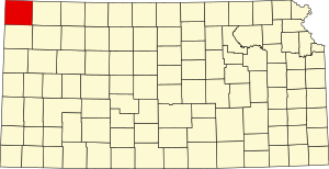
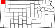
St. Francis is a city in and the county seat of Cheyenne County, Kansas, United States. As of the 2020 census, the population of the city was 1,263.

<span class="mw-page-title-main">Tecumseh, Kansas</span> Unincorporated community in Shawnee County, Kansas

Tecumseh is an unincorporated community in Shawnee County, Kansas, United States, and situated along the Kansas River. As of the 2020 census, the population of the community and nearby areas was 696. The community and township are both named for the Shawnee chief.

<span class="mw-page-title-main">Bayard, Kansas</span> Unincorporated community in Allen County, Kansas

Bayard is an unincorporated community in Allen County, Kansas, United States.

<span class="mw-page-title-main">Diamond Creek Township, Chase County, Kansas</span> Township in Kansas, United States

Diamond Creek Township is a township in Chase County, Kansas, United States. As of the 2000 census, its population was 237.

<span class="mw-page-title-main">Jaqua Township, Cheyenne County, Kansas</span> Township in Kansas, United States

Jaqua Township is a township in Cheyenne County, Kansas, USA. As of the 2000 census, its population was 46.

<span class="mw-page-title-main">Wano Township, Cheyenne County, Kansas</span> Township in Kansas, United States

Wano Township is a township in Cheyenne County, Kansas, USA. As of the 2000 census, its population was 2,104.

<span class="mw-page-title-main">Grant Township, Sherman County, Kansas</span> Township in Kansas, United States

Grant Township is one of the thirteen townships of Sherman County, Kansas, United States. The population was 115 at the 2000 census.

<span class="mw-page-title-main">Voltaire Township, Sherman County, Kansas</span>

Voltaire Township is one of the thirteen townships of Sherman County, Kansas, United States. The population was 252 at the 2000 census.

References

  1. 1 2 3 4 5 6 7 8 9 10 Blackmar 1912a, p. 327.
  2. 1 2 3 "QuickFacts; Cheyenne County, Kansas; Population, Census, 2020 & 2010". United States Census Bureau. Archived from the original on August 15, 2021. Retrieved August 15, 2021.
  3. "Find a County". National Association of Counties. Archived from the original on May 9, 2015. Retrieved June 7, 2011.
  4. 1 2 3 4 5 6 7 Blackmar 1912a, p. 325.
  5. 1 2 3 Sims & Wheeler 1887, p. 127.
  6. 1 2 3 4 5 6 7 8 Blackmar 1912a, p. 326.
  7. Mohler & Sims 1889, p. 68.
  8. 1 2 3 4 Sims & Wheeler 1887, p. 124.
  9. 1 2 Denison 1886.
  10. Denison_a 1886.
  11. Denison 1887.
  12. Denison 1889.
  13. "US Gazetteer files: 2010, 2000, and 1990". United States Census Bureau. February 12, 2011. Retrieved April 23, 2011.
  14. 1 2 3 4 5 6 Sims & Wheeler 1887, p. 125.
  15. National Atlas Archived December 5, 2008, at the Wayback Machine
  16. U.S. Census Bureau TIGER shape files
  17. "Annual Estimates of the Resident Population for Counties: April 1, 2020 to July 1, 2023". United States Census Bureau. Retrieved April 3, 2024.
  18. "U.S. Decennial Census". United States Census Bureau. Retrieved July 22, 2014.
  19. "Historical Census Browser". University of Virginia Library. Archived from the original on August 11, 2012. Retrieved July 22, 2014.
  20. "Population of Counties by Decennial Census: 1900 to 1990". United States Census Bureau. Retrieved July 22, 2014.
  21. "Census 2000 PHC-T-4. Ranking Tables for Counties: 1990 and 2000" (PDF). United States Census Bureau. Archived (PDF) from the original on March 27, 2010. Retrieved July 22, 2014.
  22. "U.S. Census website". United States Census Bureau . Retrieved January 31, 2008.
  23. "Dave Leip's Atlas of U.S. Presidential Elections".
  24. "Map of Wet and Dry Counties". Alcoholic Beverage Control, Kansas Department of Revenue. November 2006. Archived from the original on October 8, 2007. Retrieved December 26, 2007.
  25. 1 2 "General Highway Map of Cheyenne County, Kansas" (PDF). Kansas Department of Transportation (KDOT). August 2008. Archived (PDF) from the original on May 15, 2023.
  26. Mohler & Sims 1889, p. 69.
  27. Blackmar 1912a, p. 328.
  28. Mohler & Sims 1889, p. 65.
  29. Mohler & Sims 1891, p. 31.

Sources

  • Blackmar, Frank Wilson (1912). "Cheyenne County". Kansas: A Cyclopedia of State History. Vol. 1. Chicago: Standard publishing Company. pp. 325–328. LCCN   12015729. OL   13489994M. (Kansas: A Cyclopedia of State History at the Internet Archive )
  • Sims, Wm.; Wheeler, Joshua (1887). "Cheyenne County". Fifth Biennial Report of the Kansas State Board of Agriculture, for the years 18851886. Topeka, Kansas: T. S. Thacher. pp. 124–127.
  • Mohler, M.; Sims, Wm. (1889). "Cheyenne County". Sixth Biennial Report of the Kansas State Board of Agriculture, for the years 18871888. Topeka, Kansas: T. S. Thacher. pp. 65–69.
  • Mohler, M.; Sims, Wm. (1891). "Cheyenne County". Seventh Biennial Report of the Kansas State Board of Agriculture, for the years 18891890. Topeka, Kansas: T. S. Thacher. pp. 30–31.
  • Denison, C. E. (April 16, 1886). "Townships in Cheyenne county". Cheyenne County Rustler. p. 1.
  • Denison_a, C. E. (May 21, 1886). "Victory for Wano". Cheyenne County Rustler. p. 1.
  • Denison, C. E. (December 2, 1887). "Bird city vs. truth". Cheyenne County Rustler. p. 4.
  • Denison, C. E. (March 14, 1889). "Gets the county seat". Cheyenne County Rustler. p. 1.

Further reading

County
Maps