Republic County, Kansas

Last updated

Republic County
Republic Co Kansas Courthouse.JPG
Republic County Courthouse in Belleville (2010)
Map of Kansas highlighting Republic County.svg
Location within the U.S. state of Kansas
Kansas in United States.svg
Kansas's location within the U.S.
Coordinates: 39°48′N97°38′W / 39.800°N 97.633°W / 39.800; -97.633
CountryFlag of the United States.svg United States
StateFlag of Kansas.svg  Kansas
FoundedFebruary 27, 1860
Named for Republican River
Seat Belleville
Largest cityBelleville
Area
  Total720.31 sq mi (1,865.6 km2)
  Land716.38 sq mi (1,855.4 km2)
  Water3.93 sq mi (10.2 km2)  0.55%
Population
 (2020) [1]
  Total4,674
  Density6.5/sq mi (2.5/km2)
Time zone UTC−6 (Central)
  Summer (DST) UTC−5 (CDT)
Area code 785
Congressional district 1st
Website republiccounty.org
June 24, 1947, flood of the Republican River on the border of Jewell County, Kansas and Republic County, Kansas near Hardy, Nebraska and Webber, Kansas, just south of Nebraska NE-8 on Kansas 1 Rd/CR-1 bridge over the Republican River. The normal flood stage for the river is at the tree line in the foreground. RepublicanRiver1947.jpg
June 24, 1947, flood of the Republican River on the border of Jewell County, Kansas and Republic County, Kansas near Hardy, Nebraska and Webber, Kansas, just south of Nebraska NE-8 on Kansas 1 Rd/CR-1 bridge over the Republican River. The normal flood stage for the river is at the tree line in the foreground.

Republic County is a county located in the state of Kansas, south from the Nebraska state line. Its county seat and largest city is Belleville. [2] As of the 2020 census, the county population was 4,674. [1] The county was named after the Republican River.

Contents

History

Early history

For millennia, the Great Plains of North America were inhabited by nomadic Native Americans. From the 16th to 18th centuries, the Kingdom of France claimed ownership of large parts of North America. In 1762, after the French and Indian War, France ceded New France to Spain, by the Treaty of Fontainebleau.

19th century

In 1802, Spain returned most of the land to France, keeping title to about 7,500 square miles. In 1803, the land that included modern day Kansas was acquired by the United States from France as part of the 828,000 square mile Louisiana Purchase.

Prior to the arrival of settlers of European ancestry, the area was inhabited by Indian tribes including the Pawnee, Iowa, and Otoe. [3] One should also consider that other nomadic Indian tribes pursuing the buffalo, including the Arapaho, Cheyenne, Comanche, Kansa, Kiowa, Osage, and Wichita, may have made the area their home at one time or another. [4]

In 1854, under the provisions of the Kansas–Nebraska Act, the Kansas Territory was organized. In 1860, Republic County was established by the Kansas legislature. And, in 1861, Kansas became the 34th U.S. state. The county is named for the Republican River, which enters at the northwestern corner of the county, flowing slightly east of south, and leaving the county about eight miles east of the southwest corner. [3]

Daniel and Conrad Myers were the first settlers of European ancestry, arriving in February 1861. [5] By 1868, Republic County was holding elections. [6] Daniel Myers was elected judge of the Probate court and Conrad Myers to a seat on the County commission. At the election in 1869, the permanent location of the county seat was voted on with the following result: Belleville 59 and New Scandinavia 42, with a couple of votes going to other locations. [7]

Following the Civil War and during the latter half of the 19th century, Belleville and the surrounding area became a destination for European immigrants, notably from Sweden and Bohemia (now Czech Republic). [8] [9] [10]

In 1887, Atchison, Topeka and Santa Fe Railway built a branch line from Neva (3 miles west of Strong City) to Superior, Nebraska. This branch line connected Strong City, Neva, Rockland, Diamond Springs, Burdick, Lost Springs, Jacobs, Hope, Navarre, Enterprise, Abilene, Talmage, Manchester, Longford, Oak Hill, Miltonvale, Aurora, Huscher, Concordia, Kackley, Courtland, Webber, Superior. At some point, the line from Neva to Lost Springs was pulled but the right of way has not been abandoned. This branch line was originally called "Strong City and Superior line" but later the name was shortened to the "Strong City line".

In 1996, the Atchison, Topeka and Santa Fe Railway merged with Burlington Northern Railroad and was renamed the BNSF Railway, although most locals still refer to this railroad as the "Santa Fe".

Geography

According to the 2000 census, the county has a total area of 720.31 square miles (1,865.6 km2), of which 716.38 square miles (1,855.4 km2) (or 99.45%) is land and 3.93 square miles (10.2 km2) (or 0.55%) is water. [11] [12]

Adjacent counties

Demographics

Population pyramid based on 2000 census age data USA Republic County, Kansas age pyramid.svg
Population pyramid based on 2000 census age data
Historical population
CensusPop.Note
1870 1,281
1880 14,9131,064.2%
1890 19,00227.4%
1900 18,248−4.0%
1910 17,447−4.4%
1920 15,855−9.1%
1930 14,745−7.0%
1940 13,124−11.0%
1950 11,478−12.5%
1960 9,768−14.9%
1970 8,498−13.0%
1980 7,569−10.9%
1990 6,482−14.4%
2000 5,835−10.0%
2010 4,980−14.7%
2020 4,674−6.1%
2023 (est.)4,627 [13] −1.0%
U.S. Decennial Census [14]
1790-1960 [15] 1900-1990 [16]
1990-2000 [17] 2010-2020 [1]

As of the census [18] of 2000, there were 5,835 people, 2,557 households, and 1,685 families residing in the county. The population density was 8 people per square mile (3.1 people/km2). There were 3,113 housing units at an average density of 4 per square mile (1.5/km2). The racial makeup of the county was 98.56% White, 0.26% Black or African American, 0.21% Native American, 0.19% Asian, 0.33% from other races, and 0.46% from two or more races. 0.94% of the population were Hispanic or Latino of any race. 24.1% were of German, 13.6% Swedish, 12.4% Czech, 9.2% English, 9.0% Irish and 8.6% American ancestry according to Census 2000.

There were 2,557 households, out of which 25.60% had children under the age of 18 living with them, 58.80% were married couples living together, 4.80% had a woman householder with no husband present, and 34.10% were non-families. 31.80% of all households were made up of individuals, and 18.00% had someone living alone who was 65 years of age or older. The average household size was 2.23 and the average family size was 2.80.

In the county, the population was spread out, with 22.30% under the age of 18, 4.50% from 18 to 24, 22.10% from 25 to 44, 25.00% from 45 to 64, and 26.10% who were 65 years of age or older. The median age was 46 years. For every 100 women there were 93.20 men. For every 100 women age 18 and over, there were 90.80 men.

The median income for a household in the county was $30,494, and the median income for a family was $39,215. Men had a median income of $25,260 versus $17,274 for women. The per capita income for the county was $17,433. About 6.00% of families and 9.10% of the population were below the poverty line, including 12.40% of those under age 18 and 8.90% of those age 65 or over.

Government

Presidential elections

Presidential election results
United States presidential election results for Republic County, Kansas [19]
Year Republican Democratic Third party
No.%No.%No.%
2020 2,18282.12%42415.96%511.92%
2016 2,02480.03%37514.83%1305.14%
2012 2,13479.45%47717.76%752.79%
2008 1,97874.05%64023.96%531.98%
2004 2,23877.47%60721.01%441.52%
2000 2,23975.01%60420.23%1424.76%
1996 2,28369.97%68821.08%2928.95%
1992 1,76746.43%93924.67%1,10028.90%
1988 2,34667.76%1,06930.88%471.36%
1984 3,00976.49%88722.55%380.97%
1980 3,03173.57%85020.63%2395.80%
1976 2,29457.44%1,61740.49%832.08%
1972 2,92171.80%1,05926.03%882.16%
1968 2,84166.25%1,18727.68%2606.06%
1964 2,41451.65%2,22247.54%380.81%
1960 3,35865.62%1,72433.69%350.68%
1956 3,62168.76%1,61330.63%320.61%
1952 4,57376.72%1,35822.78%300.50%
1948 3,37560.42%2,10937.76%1021.83%
1944 3,80266.53%1,89133.09%220.38%
1940 4,45063.54%2,51135.86%420.60%
1936 3,83052.61%3,42747.07%230.32%
1932 2,65538.55%4,10559.61%1271.84%
1928 4,32468.19%1,95630.85%610.96%
1924 3,67159.96%1,61626.40%83513.64%
1920 3,66167.30%1,67230.74%1071.97%
1916 2,88241.65%3,80655.00%2323.35%
1912 89521.74%1,81644.12%1,40534.14%
1908 2,15651.79%1,90545.76%1022.45%
1904 2,65869.51%94124.61%2255.88%
1900 2,49955.67%1,92542.88%651.45%
1896 2,03350.93%1,91047.85%491.23%
1892 2,16750.03%00.00%2,16449.97%
1888 2,59563.77%1,20529.61%2696.61%

Republic County is overwhelmingly Republican. No Democratic presidential candidate has won the county, with the exception of Franklin D. Roosevelt in 1932 and Woodrow Wilson in 1912 and 1916. Since 1996, the Republican candidate has garnered seventy percent of the county's vote. The only Democrat since 1980 to exceed one quarter of the vote was Michael Dukakis in 1988.

Laws

Republic County was a prohibition ("dry") county until 1986, when the Kansas Constitution was amended, allowing the sale of alcoholic liquor by the individual drink with a 30 percent food sales requirement. [20]

Education

Unified school districts

Communities

2005 map of Republic County (map legend) Map of Republic Co, Ks, USA.png
2005 map of Republic County (map legend)

List of townships / incorporated cities / unincorporated communities / extinct former communities within Republic County. [21]

Cities

Unincorporated communities

† means a Census-Designated Place (CDP) by the United States Census Bureau.

Ghost towns

Townships

1915 railroad map of Republic County Stouffer's Railroad Map of Kansas 1915-1918 Republic County.png
1915 railroad map of Republic County

Republic County is divided into twenty townships. The city of Belleville is considered governmentally independent and is excluded from the census figures for the townships. In the following table, the population center is the largest city (or cities) included in that township's population total, if it is of a significant size.

Sources: 2000 U.S. Gazetteer from the U.S. Census Bureau.
Township FIPS Population
center
PopulationPopulation
density
/km2 (/sq mi)
Land area
km2 (sq mi)
Water area
km2 (sq mi)
Water %Geographic coordinates
Albion009001742 (5)92 (36)0 (0)0.12% 39°57′35″N97°25′29″W / 39.95972°N 97.42472°W / 39.95972; -97.42472
Beaver051501372 (4)91 (35)3 (1)3.04% 39°42′17″N97°51′59″W / 39.70472°N 97.86639°W / 39.70472; -97.86639
Belleville056252313 (7)89 (34)0 (0)0.11% 39°47′14″N97°38′35″W / 39.78722°N 97.64306°W / 39.78722; -97.64306
Big Bend065502423 (7)92 (35)1 (0)1.39% 39°57′0″N97°50′53″W / 39.95000°N 97.84806°W / 39.95000; -97.84806
Courtland160504505 (12)94 (36)0 (0)0.06% 39°46′56″N97°52′51″W / 39.78222°N 97.88083°W / 39.78222; -97.88083
Elk Creek202751752 (5)94 (36)0 (0)0.15% 39°42′16″N97°25′41″W / 39.70444°N 97.42806°W / 39.70444; -97.42806
Fairview225751552 (4)94 (36)0 (0)0.49% 39°52′50″N97°31′54″W / 39.88056°N 97.53167°W / 39.88056; -97.53167
Farmington23200811 (2)93 (36)0 (0)0.20% 39°52′20″N97°25′24″W / 39.87222°N 97.42333°W / 39.87222; -97.42333
Freedom246751862 (5)90 (35)0 (0)0.28% 39°51′31″N97°38′26″W / 39.85861°N 97.64056°W / 39.85861; -97.64056
Grant28050771 (2)95 (37)0 (0)0.15% 39°42′5″N97°32′31″W / 39.70139°N 97.54194°W / 39.70139; -97.54194
Jefferson353251071 (3)95 (37)0 (0)0.05% 39°47′29″N97°32′33″W / 39.79139°N 97.54250°W / 39.79139; -97.54250
Liberty40325521 (1)93 (36)0 (0)0.19% 39°57′2″N97°38′30″W / 39.95056°N 97.64167°W / 39.95056; -97.64167
Lincoln410751031 (3)92 (36)0 (0)0.09% 39°41′58″N97°38′57″W / 39.69944°N 97.64917°W / 39.69944; -97.64917
Norway515751632 (5)92 (36)1 (0)1.19% 39°42′17″N97°46′9″W / 39.70472°N 97.76917°W / 39.70472; -97.76917
Richland595753183 (9)92 (36)0 (0)0.11% 39°47′30″N97°26′4″W / 39.79167°N 97.43444°W / 39.79167; -97.43444
Rose Creek612001702 (5)94 (36)0 (0)0.44% 39°57′27″N97°32′13″W / 39.95750°N 97.53694°W / 39.95750; -97.53694
Scandia633755416 (15)92 (36)1 (0)1.23% 39°47′28″N97°46′27″W / 39.79111°N 97.77417°W / 39.79111; -97.77417
Union72300511 (1)93 (36)0 (0)0.18% 39°52′0″N97°46′5″W / 39.86667°N 97.76806°W / 39.86667; -97.76806
Washington75700951 (3)93 (36)0 (0)0.24% 39°57′57″N97°45′14″W / 39.96583°N 97.75389°W / 39.96583; -97.75389
White Rock77975881 (2)92 (36)1 (0)1.09% 39°52′34″N97°51′54″W / 39.87611°N 97.86500°W / 39.87611; -97.86500

Notable people

Arts and entertainment
Athletes
Clergy
Journalists
Medicine
Philanthropy
Politicians
Settlers

See also

Community information for Kansas

Related Research Articles

<span class="mw-page-title-main">Wyandotte County, Kansas</span> County in Kansas, United States

Wyandotte County is a county in the U.S. state of Kansas. Its county seat and most populous city is Kansas City, with which it shares a unified government. As of the 2020 census, the population was 169,245, making it Kansas's fourth-most populous county. The county was named after the Wyandot tribe.

<span class="mw-page-title-main">Morris County, Kansas</span> County in Kansas, United States

Morris County is a county located in the U.S. state of Kansas. Its county seat and largest city is Council Grove. As of the 2020 census, the county population was 5,386. The county was named for Thomas Morris, a U.S. Senator from Ohio and anti-slavery advocate.

<span class="mw-page-title-main">Mitchell County, Kansas</span> County in Kansas, United States

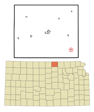
Mitchell County is a county located in the U.S. state of Kansas. Its county seat and largest city is Beloit. As of the 2020 census, the county population was 5,796. The county was named for William Mitchell.

<span class="mw-page-title-main">Jewell County, Kansas</span> County in Kansas, United States

Jewell County is a county located in the U.S. state of Kansas. Its county seat and most populous city is Mankato. As of the 2020 census, the county population was 2,932. The county was named for Lewis Jewell, a lieutenant colonel of the 6th Regiment Kansas Volunteer Cavalry.

<span class="mw-page-title-main">Ellsworth County, Kansas</span> County in Kansas, United States

Ellsworth County is a county located in the U.S. state of Kansas. Its county seat and most populous city is Ellsworth. As of the 2020 census, the county population was 6,376. The county was named after Fort Ellsworth.

<span class="mw-page-title-main">Dickinson County, Kansas</span> County in Kansas, United States

Dickinson County is a county in Central Kansas. Its county seat and most populous city is Abilene. As of the 2020 census, the county population was 18,402. The county was named in honor of Daniel Dickinson, a U.S. Senator from New York that was a Kansas statehood advocate.

<span class="mw-page-title-main">Cloud County, Kansas</span> County in Kansas, United States

Cloud County is a county located in the U.S. state of Kansas. Its county seat and most populous city is Concordia. As of the 2020 census, the county population was 9,032. The county was named after William Cloud, an officer in the American Civil War.

<span class="mw-page-title-main">Brown County, Kansas</span> County in Kansas, United States

Brown County is a county located in the northeast portion of the U.S. state of Kansas. Its county seat and most populous city is Hiawatha. As of the 2020 census, the county population was 9,508. The county was named after Albert G. Brown, a U.S. Senator from Mississippi and Kansas statehood advocate. The Kickapoo Indian Reservation of Kansas, the majority of the Sac and Fox Reservation, and the majority of the Iowa Reservation of Kansas and Nebraska are located within the county.

<span class="mw-page-title-main">Randall, Kansas</span> City in Jewell County, Kansas

Randall is a city in Jewell County, Kansas, United States. As of the 2020 census, the population of the city was 79.

<span class="mw-page-title-main">Webber, Kansas</span> City in Jewell County, Kansas

Webber is a city in Jewell County, Kansas, United States. As of the 2020 census, the population of the city was 30.

<span class="mw-page-title-main">Beloit, Kansas</span> City in Mitchell County, Kansas

Beloit is a city in and the county seat of Mitchell County, Kansas, United States. As of the 2020 census, the population of the city was 3,404.

<span class="mw-page-title-main">Agenda, Kansas</span> City in Republic County, Kansas

Agenda is a city in Republic County, Kansas, United States. As of the 2020 census, the population of the city was 47.

<span class="mw-page-title-main">Belleville, Kansas</span> City in Republic County, Kansas

Belleville is a city in and the county seat of Republic County, Kansas, United States. As of the 2020 census, the population of the city was 2,007.

<span class="mw-page-title-main">Courtland, Kansas</span> City in Republic County, Kansas

Courtland is a city in Republic County, Kansas, United States. As of the 2020 census, the population of the city was 294.

<span class="mw-page-title-main">Scandia, Kansas</span> City in Republic County, Kansas

Scandia is a city in Republic County, Kansas, United States. As of the 2020 census, the population of the city was 344.

<span class="mw-page-title-main">Byron, Nebraska</span> Village in Thayer County, Nebraska, United States

Byron is a village in Thayer County, Nebraska, United States, and its south edge is the Nebraska-Kansas state border. The population was 85 at the 2020 census.

<span class="mw-page-title-main">Elizabeth Johnson (advocate)</span> American advocate of Kansas history

Elizabeth A. Johnson was a prominent advocate of Kansas history. She discovered, purchased, and donated the land that makes up the Pawnee Indian Museum State Historic Site to the state of Kansas in 1899. At the time, it was considered to be the first place the United States flag was raised on the state of Kansas.

Isaac O. Savage was an early writer of the history of Republic County, Kansas. He was active in the community as a local politician and later served as a state senator in the Kansas legislature.

White Rock is a ghost town in Republic County, Kansas, United States. It is located 6 miles (9.7 km) north of Courtland.

Harbine is an unincorporated community in Republic County, Kansas, United States. It is located south of Byron, Nebraska on the south side of the Nebraska state line.

References

  1. 1 2 3 "QuickFacts; Republic County, Kansas; Population, Census, 2020 & 2010". United States Census Bureau. Archived from the original on August 19, 2021. Retrieved August 19, 2021.
  2. "Find a County". National Association of Counties. Retrieved June 7, 2011.
  3. 1 2 Savage., I. O. (1901). Carolyn Ward (ed.). A history of Republic County, Kansas: embracing a full and complete account of all the leading events in its history, from its first settlement down to June 1, '01. Beloit, Kansas: Jones & Chubbic. p. 32.
  4. "American Indians in Kansas - Kansapedia - Kansas Historical Society".
  5. Savage., I. O. (1901). Carolyn Ward (ed.). A history of Republic County, Kansas: embracing a full and complete account of all the leading events in its history, from its first settlement down to June 1, '01. Beloit, Kansas: Jones & Chubbic. p. 35.
  6. Savage., I. O. (1901). Carolyn Ward (ed.). A history of Republic County, Kansas: embracing a full and complete account of all the leading events in its history, from its first settlement down to June 1, '01. Beloit, Kansas: Jones & Chubbic. p. 115.
  7. Savage., I. O. (1901). Carolyn Ward (ed.). A history of Republic County, Kansas: embracing a full and complete account of all the leading events in its history, from its first settlement down to June 1, '01. Beloit, Kansas: Jones & Chubbic. p. 63.
  8. I. O. Savage, History of Republic County (1883), p. 68; New Scandinavia's Ninety-Three Years, 1868–1961 (Scandia, 1961), pp. 3-5.
  9. Nemcova, Bozena. "People of Czech Bohemian Descent in Republic County, Kansas." Master's thesis, University of Kansas, 1950. (Reel: LM 205).
  10. https://www.kshs.org/p/bohemians-czechs-and-moravians-to-kansas-a-bibliography/13535 |Kansas Historical Society, Bohemians, Czechs, Moravians Bibliography
  11. "Census 2000 U.S. Gazetteer Files: Counties". United States Census. Retrieved February 13, 2011.
  12. "US Gazetteer files: 2010, 2000, and 1990". United States Census Bureau. February 12, 2011. Retrieved April 23, 2011.
  13. "Annual Estimates of the Resident Population for Counties: April 1, 2020 to July 1, 2023". United States Census Bureau. Retrieved April 3, 2024.
  14. "U.S. Decennial Census". United States Census Bureau. Retrieved July 28, 2014.
  15. "Historical Census Browser". University of Virginia Library. Retrieved July 28, 2014.
  16. "Population of Counties by Decennial Census: 1900 to 1990". United States Census Bureau. Retrieved July 28, 2014.
  17. "Census 2000 PHC-T-4. Ranking Tables for Counties: 1990 and 2000" (PDF). United States Census Bureau. Archived (PDF) from the original on March 27, 2010. Retrieved July 28, 2014.
  18. "U.S. Census website". United States Census Bureau . Retrieved January 31, 2008.
  19. "Dave Leip's Atlas of U.S. Presidential Elections".
  20. "Map of Wet and Dry Counties". Alcoholic Beverage Control, Kansas Department of Revenue. November 2006. Archived from the original on October 8, 2007. Retrieved December 28, 2007.
  21. 1 2 "General Highway Map of Republic County, Kansas" (PDF). Kansas Department of Transportation (KDOT). December 2011. Archived (PDF) from the original on June 19, 2023.
  22. Greta Granstedt Biography at IMDb
  23. Harry A. Pollard at IMDb
  24. "Herb Bradley". Retrosheet.com. Retrieved March 25, 2012.
  25. "Tom Bushby". Pro Football Reference.com. Retrieved March 28, 2012.
  26. "Larry Cheney Stats". Baseball Almanac.com. Retrieved March 25, 2012.
  27. "KATS Hall of Fame". Kansas Athletic Trainers Society. Archived from the original on July 6, 2012. Retrieved September 14, 2012.
  28. "Tony Zuzzio". DatabaseFootball.com. Archived from the original on June 1, 2012. Retrieved March 28, 2012.
  29. "In memoriam: Allen Wikgren". The University of Chicago Chronicle. June 11, 1998. Retrieved March 27, 2012.
  30. Cutler, William (1883). "4". History of the State of Kansas. Chicago, Illinois: A. T. Andreas. Archived from the original on October 19, 2003. Retrieved April 2, 2012.
  31. "Miller, A.Q." Kansas Press Association. Retrieved June 18, 2018.
  32. Cutler, William (1883). "3". History of the State of Kansas. Chicago, Illinois: A. T. Andreas. Archived from the original on May 10, 2003.
  33. Savage, I. O. (1901). Carolyn Ward (ed.). A history of Republic County, Kansas: embracing a full and complete account of all the leading events in its history, from its first settlement down to June 1, '01. Beloit, Kansas: Published by Jones & Chubbic. pp. 11, 20. Retrieved March 25, 2012.
  34. Project Vote Smart - Rep. Aurand Biography
  35. "JOHNSON, Edwin Carl, (1884 - 1970)". United States Congress . Retrieved March 25, 2012.
  36. Former justice dies at age 85. Statesman Journal , November 1, 1985.
  37. "Kansas Legislators Past and Present > Saar to Scott". Kansas State Library. Retrieved March 25, 2012.
  38. Cutler, William (1883). "REPUBLIC COUNTY, Part 6: Scandia". History of the State of Kansas. Chicago, Illinois: A. T. Andreas. Archived from the original on September 4, 2003. Retrieved April 3, 2012.
  39. Blackmar, Frank (1912). Kansas: a cyclopedia of state history, embracing events, institutions, industries, counties, cities, towns, prominent persons, etc. Chicago, Illinois: Standard Publishing Company. p. 907.
  40. "Lovewell Family Meets at Lovewell Lake". The Superior Express. June 7, 2007. Retrieved March 27, 2012.

Further reading

County
Other
Maps