Wabaunsee County, Kansas

Last updated

Wabaunsee County
Wabaunsee County Courthouse.jpg
Wabaunsee County Courthouse in Alma (2021)
Map of Kansas highlighting Wabaunsee County.svg
Location within the U.S. state of Kansas
Kansas in United States.svg
Kansas's location within the U.S.
Coordinates: 39°01′07″N96°17′33″W / 39.0186°N 96.2925°W / 39.0186; -96.2925
CountryFlag of the United States.svg United States
StateFlag of Kansas.svg  Kansas
Founded1859
Named for Chief Waubonsie
Seat Alma
Largest cityAlma
Area
  Total800 sq mi (2,000 km2)
  Land794 sq mi (2,060 km2)
  Water5.3 sq mi (14 km2)  0.7%
Population
 (2020) [1]
  Total6,877
  Estimate 
(2021) [2]
6,966
  Density8.7/sq mi (3.4/km2)
Time zone UTC−6 (Central)
  Summer (DST) UTC−5 (CDT)
Congressional district 2nd
Website wbcounty.org

Wabaunsee County is a county located in the U.S. state of Kansas. Its county seat is Alma. [3] As of the 2020 census, the county population was 6,877. [1] The county was named for Chief Waubonsie of the Potawatomi Indians. [4]

Contents

History

Wabaunsee County Poor Farm, located 4 mi (6.4 km) south of Alma, 1901 Poor Farm - Wabaunsee County, Kansas (1901.jpg
Wabaunsee County Poor Farm, located 4 mi (6.4 km) south of Alma, 1901

19th century

For millennia, the land now known as Kansas was inhabited by Native Americans. In 1803, most of modern Kansas was secured by the United States as part of the Louisiana Purchase. The first white settlers in the area were said to have been a band of outlaws known as the McDaniel Gang. [4]

In 1854, the Kansas Territory was organized and Wabaunsee County was created by the territorial legislature on March 25, 1859. [4] The name used since 1859 is derived from the Potawatomi "Wah-bon-seh", meaning "dawn of day" literally, and it was the name of the chief of the Potawatomi Indians. [4] Originally, the county was named Richardson, after William Alexander Richardson, a congressman from Illinois, who introduced the first Kansas and Nebraska Bill in the House of Representatives, which made certain Indian lands territories in 1854. [5]

Also in 1854, the Beecher Bible and Rifle Church was established by a group of free-staters, who had rifles shipped to the church to be used in the free-state effort in boxes marked Bibles. [4] Captain William Mitchell, Jr., a seaman who joined the Beecher Bible and Rifle Colony that settled in Wabaunsee, played an important role in the county settlement and with the underground railroad. [4]

The county's first church, Wabaunsee Church of Christ, was founded in June 1857. [4]

In 1861 Kansas became the 34th U.S. state, entering the union as a free state.

The first railroad to be built through Wabaunsee County was the Atchison, Topeka, and Santa Fe in 1880. [6] In 1887, the Chicago, Kansas and Nebraska Railway built a main line from Topeka to Herington. [7] This main line connected Topeka, Valencia, Willard, Maple Hill, Vera, Paxico, McFarland, Alma, Volland, Alta Vista, Dwight, White City, Latimer, Herington.

20th century

A massive drought beginning in 1930 resulted in a series of dust storms that lasted until 1941. The drought combined with the onset of the Great Depression, forced farmers off the land. This ecological disaster caused an exodus of many farmers to escape from the hostile environment of Kansas. [8] [9] As the world demand for wheat plummeted, rural Kansas became poverty-stricken. The state became an eager participant in such major New Deal relief programs as the Civil Works Administration, the Federal Emergency Relief Administration, the Civilian Conservation Corps, the Works Progress Administration, which put tens of thousands of Kansans to work as unskilled labor. [10] Republican Governor Alf Landon also employed emergency measures, including a moratorium on mortgage foreclosures and a balanced budget initiative. [11] The Agricultural Adjustment Administration succeeded in raising wheat prices after 1933, thus alleviating the most serious distress. [12]

During World War II, the U.S. Army located a German prisoner of war camp at Lake Wabaunsee, near Eskridge. It was believed that the prisoners would be less of a security risk in North America, where there were fewer Nazi sympathizers, than they would be in Europe. The prisoners were paid $0.40 per hour and granted a daily noon lunch, in exchange for their help on farms and bridges throughout the region. [13]

Geography

According to the U.S. Census Bureau, the county has a total area of 800 square miles (2,100 km2), of which 794 square miles (2,060 km2) is land and 5.3 square miles (14 km2) (0.7%) is water. [14]

Adjacent counties

Demographics

Population pyramid based on 2000 census age data USA Wabaunsee County, Kansas age pyramid.svg
Population pyramid based on 2000 census age data
Historical population
CensusPop.Note
1860 1,023
1870 3,362228.6%
1880 8,756160.4%
1890 11,72033.9%
1900 12,8139.3%
1910 12,721−0.7%
1920 11,424−10.2%
1930 10,830−5.2%
1940 9,219−14.9%
1950 7,212−21.8%
1960 6,648−7.8%
1970 6,397−3.8%
1980 6,8677.3%
1990 6,603−3.8%
2000 6,8854.3%
2010 7,0532.4%
2020 6,877−2.5%
2023 (est.)7,057 [15] 2.6%
U.S. Decennial Census [16]
1790-1960 [17] 1900-1990 [18]
1990-2000 [19] 2010-2020 [1]

Wabaunsee County is part of the Topeka, KS Metropolitan Statistical Area.

As of the census [20] of 2000, there were 6,885 people, 2,633 households, and 1,958 families residing in the county. The population density was 9 people per square mile (3.5 people/km2). There were 3,033 housing units at an average density of 4 per square mile (1.5/km2). The racial makeup of the county was 97.24% White, 0.46% Black or African American, 0.49% Native American, 0.15% Asian, 0.06% Pacific Islander, 0.60% from other races, and 1.00% from two or more races. 1.86% of the population were Hispanic or Latino of any race.

There were 2,633 households, out of which 33.50% had children under the age of 18 living with them, 64.30% were married couples living together, 6.30% had a female householder with no husband present, and 25.60% were non-families. 23.00% of all households were made up of individuals, and 10.80% had someone living alone who was 65 years of age or older. The average household size was 2.57 and the average family size was 3.01.

In the county, the population was spread out, with 26.70% under the age of 18, 6.20% from 18 to 24, 26.70% from 25 to 44, 24.80% from 45 to 64, and 15.60% who were 65 years of age or older. The median age was 40 years. For every 100 females, there were 102.50 males. For every 100 females age 18 and over, there were 101.30 males.

The median income for a household in the county was $41,710, and the median income for a family was $47,500. Males had a median income of $31,629 versus $23,148 for females. The per capita income for the county was $17,704. About 5.80% of families and 7.30% of the population were below the poverty line, including 8.40% of those under age 18 and 7.90% of those age 65 or over.

Government

County governance is overseen by a three member Board of Commissioners, each of whom is responsible for a separate district. [21]

Presidential elections

Presidential election results
United States presidential election results for Wabaunsee County, Kansas [22]
Year Republican Democratic Third party
No.%No.%No.%
2020 2,84572.91%96424.71%932.38%
2016 2,37270.18%77622.96%2326.86%
2012 2,25669.05%91828.10%932.85%
2008 2,39568.02%1,03629.42%902.56%
2004 2,53170.23%1,00127.77%722.00%
2000 2,18263.80%1,02529.97%2136.23%
1996 1,88455.67%96628.55%53415.78%
1992 1,25437.17%85125.22%1,26937.61%
1988 1,73758.54%1,16639.30%642.16%
1984 2,27672.72%80525.72%491.57%
1980 2,25567.98%85325.72%2096.30%
1976 1,92157.58%1,35440.59%611.83%
1972 2,46176.83%66220.67%802.50%
1968 1,97964.17%69522.54%41013.29%
1964 1,83958.34%1,28740.83%260.82%
1960 2,35170.58%96929.09%110.33%
1956 2,65076.63%80223.19%60.17%
1952 3,18281.03%73618.74%90.23%
1948 2,43766.80%1,16231.85%491.34%
1944 2,83975.95%87323.35%260.70%
1940 3,48173.64%1,21225.64%340.72%
1936 2,80955.52%2,23544.18%150.30%
1932 2,30447.39%2,46550.70%931.91%
1928 3,09971.89%1,18927.58%230.53%
1924 2,74265.90%63315.21%78618.89%
1920 2,85977.63%78221.23%421.14%
1916 2,64058.95%1,70638.10%1322.95%
1912 78326.82%1,12838.63%1,00934.55%
1908 1,84960.25%1,16337.90%571.86%
1904 2,01671.44%68824.38%1184.18%
1900 1,79358.06%1,26340.90%321.04%
1896 1,58651.80%1,44247.09%341.11%
1892 1,35646.82%00.00%1,54053.18%
1888 1,70862.52%96035.14%642.34%

Wabaunsee County is overwhelmingly Republican. No Democratic presidential candidate has won Wabaunsee County since Franklin D. Roosevelt in 1932, and since at least 1888 only Roosevelt in 1932 and 1936, plus William Jennings Bryan in 1896, have reached 41 percent of the county's vote for the Democratic Party. The county was however one of three Kansas counties – Anderson and Jefferson being the other two – to give a plurality to Ross Perot in 1992.

Laws

Wabaunsee County was a prohibition, or "dry", county until the Kansas Constitution was amended in 1986 and voters approved the sale of alcoholic liquor by the individual drink with a 30 percent food sales requirement. [23]

Education

Unified school districts

Communities

2005 KDOT Map of Wabaunsee County from KDOT (map legend) Map of Wabaunsee Co, Ks, USA.png
2005 KDOT Map of Wabaunsee County from KDOT (map legend)

‡ denotes a community with portions in an adjacent county. † denotes a community which is designated a Census-Designated Place (CDP) by the United States Census Bureau.

Cities

Unincorporated communities

Ghost towns

Townships

1915 Railroad Map of Wabaunsee County Stouffer's Railroad Map of Kansas 1915-1918 Wabaunsee County.png
1915 Railroad Map of Wabaunsee County

Wabaunsee County is divided into thirteen townships. None of the cities within the county are considered governmentally independent, and all figures for the townships include those of the cities. In the following table, the population center is the largest city (or cities) included in that township's population total, if it is of a significant size.

Sources: 2000 U.S. Gazetteer from the U.S. Census Bureau.
Township FIPS Population
center
PopulationPopulation
density
/km2 (/sq mi)
Land area
km2 (sq mi)
Water area
km2 (sq mi)
Water %Geographic coordinates
Alma01375Alma1,13711 (28)104 (40)0 (0)0% 39°1′8″N96°17′33″W / 39.01889°N 96.29250°W / 39.01889; -96.29250
Farmer231251191 (2)172 (66)0 (0)0.07% 38°55′37″N96°18′44″W / 38.92694°N 96.31222°W / 38.92694; -96.31222
Garfield25850Alta Visa5905 (13)118 (45)0 (0)0.09% 38°51′44″N96°27′20″W / 38.86222°N 96.45556°W / 38.86222; -96.45556
Kaw361502422 (6)110 (42)2 (1)1.55% 39°10′16″N96°9′46″W / 39.17111°N 96.16278°W / 39.17111; -96.16278
Maple Hill44525Maple Hill9305 (13)190 (73)1 (0)0.55% 39°4′43″N96°0′52″W / 39.07861°N 96.01444°W / 39.07861; -96.01444
Mill Creek46725Lake Wabaunsee2932 (4)192 (74)1 (0)0.43% 38°53′23″N96°11′23″W / 38.88972°N 96.18972°W / 38.88972; -96.18972
Mission Creek473004952 (6)209 (81)0 (0)0.04% 38°55′49″N96°3′0″W / 38.93028°N 96.05000°W / 38.93028; -96.05000
Newbury50275Paxico / McFarland1,0455 (13)203 (78)0 (0)0.06% 39°3′44″N96°11′18″W / 39.06222°N 96.18833°W / 39.06222; -96.18833
Plumb56800Harveyville6405 (13)129 (50)0 (0)0.17% 38°47′56″N95°58′36″W / 38.79889°N 95.97667°W / 38.79889; -95.97667
Rock Creek60650840 (1)171 (66)0 (0)0.05% 38°46′58″N96°18′15″W / 38.78278°N 96.30417°W / 38.78278; -96.30417
Wabaunsee74250Wabaunsee4553 (7)172 (66)2 (1)1.05% 39°6′57″N96°18′21″W / 39.11583°N 96.30583°W / 39.11583; -96.30583
Washington75800831 (1)148 (57)0 (0)0.02% 38°57′49″N96°25′14″W / 38.96361°N 96.42056°W / 38.96361; -96.42056
Wilmington79525Eskridge7725 (13)150 (58)0 (0)0.03% 38°49′54″N96°6′14″W / 38.83167°N 96.10389°W / 38.83167; -96.10389

See also

Community information for Kansas

Related Research Articles

<span class="mw-page-title-main">Sumner County, Kansas</span> County in Kansas, United States

Sumner County is a county located in the U.S. state of Kansas. Its county seat is Wellington. As of the 2020 census, the population was 22,382. The county is named after Charles Sumner, a U.S. Senator from Massachusetts who was a leader of Reconstruction politics.

<span class="mw-page-title-main">Shawnee County, Kansas</span> County in Kansas, United States

Shawnee County is located in northeast Kansas, in the central United States. Its county seat and most populous city is Topeka, the state capital. As of the 2020 census, the population was 178,909, making it the third-most populous county in Kansas. The county was one of the original 33 counties created by the first territorial legislature in 1855, and it was named for the Shawnee tribe.

<span class="mw-page-title-main">Reno County, Kansas</span> County in Kansas, United States

Reno County is a county located in the U.S. state of Kansas. Its county seat and largest city is Hutchinson. As of the 2020 census, the population was 61,898. The county is named for Jesse Reno, a general during the American Civil War.

<span class="mw-page-title-main">Pottawatomie County, Kansas</span> County in Kansas, United States

Pottawatomie County is a county located in the U.S. state of Kansas. Its county seat is Westmoreland. As of the 2020 census, the county population was 25,348. The county was named for the Potawatomi tribe.

<span class="mw-page-title-main">Osage County, Kansas</span> County in Kansas, United States

Osage County is a county located in the U.S. state of Kansas. Its county seat is Lyndon, and its most populous city is Osage City. As of the 2020 census, the county population was 15,766. The county was originally organized in 1855 as Weller County, then renamed in 1859 after the Osage tribe.

<span class="mw-page-title-main">Morris County, Kansas</span> County in Kansas, United States

Morris County is a county located in the U.S. state of Kansas. Its county seat and largest city is Council Grove. As of the 2020 census, the county population was 5,386. The county was named for Thomas Morris, a U.S. Senator from Ohio and anti-slavery advocate.

<span class="mw-page-title-main">McPherson County, Kansas</span> County in Kansas, United States

McPherson County is a county located in the U.S. state of Kansas. Its county seat and largest city is McPherson. As of the 2020 census, the county population was 30,223. The county was named for James McPherson, a general in the American Civil War.

<span class="mw-page-title-main">Jackson County, Kansas</span> County in Kansas, United States

Jackson County is a county in the U.S. state of Kansas. Its county seat and most populous city is Holton. As of the 2020 census, the county population was 13,232. The county, first named Calhoun County for pro-slavery South Carolina Senator John C. Calhoun, was renamed in 1859 for President Andrew Jackson. The Prairie Band Potawatomi Indian Reservation, near the center of the county, comprises about 18.5% of the county's area.

<span class="mw-page-title-main">Harvey County, Kansas</span> County in Kansas, United States

Harvey County is a county located in the U.S. state of Kansas. Its county seat and most populous city is Newton. As of the 2020 census, the county population was 34,024. The county was named for James Harvey, a U.S. senator and 5th governor of Kansas.

<span class="mw-page-title-main">Dickinson County, Kansas</span> County in Kansas, United States

Dickinson County is a county in Central Kansas. Its county seat and most populous city is Abilene. As of the 2020 census, the county population was 18,402. The county was named in honor of Daniel Dickinson, a U.S. Senator from New York that was a Kansas statehood advocate.

<span class="mw-page-title-main">Coffey County, Kansas</span> County in Kansas, United States

Coffey County is a county located in Eastern Kansas. Its county seat and most populous city is Burlington. As of the 2020 census, the county population was 8,360. It was named after A.M. Coffey, a territorial legislator and Free-Stater during Bleeding Kansas era.

<span class="mw-page-title-main">Chase County, Kansas</span> County in Kansas, United States

Chase County is a county located in the U.S. state of Kansas. Its county seat and most populous city is Cottonwood Falls. As of the 2020 census, the county population was 2,572. The county was named for Salmon Chase, a U.S. Senator from Ohio that was a Kansas statehood advocate.

<span class="mw-page-title-main">Barton County, Kansas</span> County in Kansas, United States

Barton County is a county located in the U.S. state of Kansas. Its county seat and most populous city is Great Bend. As of the 2020 census, the county population was 25,493. The county is named in honor of Clara Barton, responsible for the founding of the American Red Cross, and the only county in Kansas to be named for a woman.

<span class="mw-page-title-main">Alma, Kansas</span> City in Wabaunsee County, Kansas

Alma is a city in and the county seat of Wabaunsee County, Kansas, United States. As of the 2020 census, the population of the city was 802.

<span class="mw-page-title-main">Alta Vista, Kansas</span> City in Wabaunsee County, Kansas

Alta Vista is a city in Wabaunsee County, Kansas, United States. As of the 2020 census, the population of the city was 409.

<span class="mw-page-title-main">Maple Hill, Kansas</span> City in Wabaunsee County, Kansas

Maple Hill is a city in Wabaunsee County, Kansas, United States. As of the 2020 census, the population of the city was 631.

<span class="mw-page-title-main">McFarland, Kansas</span> City in Wabaunsee County, Kansas

McFarland is a city in Wabaunsee County, Kansas, United States. As of the 2020 census, the population of the city was 272.

<span class="mw-page-title-main">Paxico, Kansas</span> City in Wabaunsee County, Kansas

Paxico is a city in Wabaunsee County, Kansas, United States. As of the 2020 census, the population of the city was 210.

<span class="mw-page-title-main">Willard, Kansas</span> City in Shawnee and Wabaunsee Counties of Kansas

Willard is a city in Shawnee and Wabaunsee counties in the State of Kansas in the United States. As of the 2020 census, the population of the city was 74.

<span class="mw-page-title-main">Newbury, Kansas</span> Unincorporated community in Wabaunsee County, Kansas

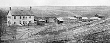
Newbury is an unincorporated community in Wabaunsee County, Kansas, United States. As of the 2020 census, the population of the community and nearby areas was 78. It is located approximately 2 miles northwest of Paxico.

References

  1. 1 2 3 "QuickFacts; Wabaunsee County, Kansas; Population, Census, 2020 & 2010". United States Census Bureau. Archived from the original on August 22, 2021. Retrieved August 21, 2021.
  2. "County Population Totals: 2020-2021". United States Census Bureau. March 24, 2022. Retrieved June 3, 2022.
  3. "Find a County". National Association of Counties. Retrieved June 7, 2011.
  4. 1 2 3 4 5 6 7 Wabaunsee County, Kansas, Kansapedia. (accessed July 27, 2013)
  5. Wabaunsee County History.
  6. Blackmar, Frank Wilson (1912). Kansas: A Cyclopedia of State History, Volume 2. Standard Publishing Company. pp.  853.
  7. "Rock Island Rail History". Archived from the original on June 19, 2011. Retrieved May 29, 2013.
  8. Timothy Eagan, The Worst Hard Tim : the Untold Story of Those Who Survived the Great American Dust Bowl (Houghton Mifflin, 2006)
  9. Craig Miner,Next Year Country: Dust to Dust in Western Kansas, 1890-1940 (2007)
  10. Peter Fearon, "Kansas History and the New Deal Era," Kansas History, Autumn 2007, Vol. 30 Issue 3, pp 192-223
  11. Donald R. McCoy, Landon of Kansas (1966)
  12. Peter Fearon, "Regulation and Response: Kansas Wheat Farmers and the New Deal," Rural History, Oct 2007, Vol. 18 Issue 2, pp 245-264
  13. "Lake Wabaunsee". Lake Wabaunsee. Retrieved September 12, 2017.
  14. "US Gazetteer files: 2010, 2000, and 1990". United States Census Bureau. February 12, 2011. Retrieved April 23, 2011.
  15. "Annual Estimates of the Resident Population for Counties: April 1, 2020 to July 1, 2023". United States Census Bureau. Retrieved April 3, 2024.
  16. "U.S. Decennial Census". United States Census Bureau. Retrieved July 29, 2014.
  17. "Historical Census Browser". University of Virginia Library. Retrieved July 29, 2014.
  18. "Population of Counties by Decennial Census: 1900 to 1990". United States Census Bureau. Retrieved July 29, 2014.
  19. "Census 2000 PHC-T-4. Ranking Tables for Counties: 1990 and 2000" (PDF). United States Census Bureau. Archived (PDF) from the original on March 27, 2010. Retrieved July 29, 2014.
  20. "U.S. Census website". United States Census Bureau . Retrieved January 31, 2008.
  21. Wabaunsee County, County Commission, accessed September 1, 2023
  22. "Dave Leip's Atlas of U.S. Presidential Elections".
  23. "Map of Wet and Dry Counties". Alcoholic Beverage Control, Kansas Department of Revenue. November 2006. Archived from the original on October 8, 2007. Retrieved December 28, 2007.

Further reading

County
Historical
Maps

38°58′N96°11′W / 38.967°N 96.183°W / 38.967; -96.183