Kiowa County, Kansas

Last updated

Kiowa County
Kiowa county kansas courthouse 2009.jpg
Renovated County Courthouse in Greensburg (2009) after a tornado damaged it in 2007. Construction of the building started in 1920.
Map of Kansas highlighting Kiowa County.svg
Location within the U.S. state of Kansas
Kansas in United States.svg
Kansas's location within the U.S.
Coordinates: 37°34′00″N99°17′00″W / 37.5667°N 99.2833°W / 37.5667; -99.2833
CountryFlag of the United States.svg United States
StateFlag of Kansas.svg  Kansas
FoundedFebruary 26, 1867
Named for Kiowa tribe
Seat Greensburg
Largest cityGreensburg
Area
  Total723 sq mi (1,870 km2)
  Land723 sq mi (1,870 km2)
  Water0.2 sq mi (0.5 km2)  0.03%
Population
 (2020) [1]
  Total2,460
  Density3.4/sq mi (1.3/km2)
Time zone UTC−6 (Central)
  Summer (DST) UTC−5 (CDT)
Congressional district 4th
Website kiowacountyks.org

Kiowa County is a county located in the U.S. state of Kansas. Its county seat and largest city is Greensburg. [2] As of the 2020 census, the county population was 2,460. [1] The county is named after the Kiowa tribe.

Contents

History

19th century

In 1854, the Kansas Territory was organized, then in 1861 Kansas became the 34th U.S. state. In 1867, Kiowa County was established and named after the Kiowa tribe. [3] In 1875. The county’s land was given to nearby county, but in 1886, Kiowa County was reestablished and organized. [4]

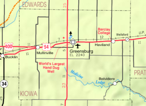
The Santa Fe Railroad was built into the county around the time it was organized. The Greensburg Well, one of the largest hand-dug wells in the world, was built in 1887-1888. It has been a popular tourist attraction since 1939. The well is listed in the National Register of Historic Places. [4]

The first oil well in Kiowa County was drilled in 1917. [4]

Mabel Chase ran for county sheriff after her husband’s time in the office was term-limited and became the state's first female sheriff. Her husband provided her the family’s armored 1926 Hudson Super Six, and she was the first sheriff in Kansas to be supplied with a Thompson submachine gun. Chase conducted raids on local stills. [4]

21st century

On the evening of May 4, 2007, Greensburg was devastated by an EF5 tornado during the May 2007 tornado outbreak. It killed 11 and destroyed 95% of the community.

The Kiowa County Courthouse was renovated with new windows and roof after the 2007 tornado damaged it. Originally, construction of the building started in 1920.

Geography

According to the U.S. Census Bureau, the county has a total area of 723 square miles (1,870 km2), of which 723 square miles (1,870 km2) is land and 0.2 square miles (0.52 km2) (0.03%) is water. [5]

Kiowa County has a large number of iron-rich meteorites in its soil due to the Brenham meteor fall over 10 thousand years ago.

Adjacent counties

Major highways

Kiowa County has only U.S. highways, no state highways.

Demographics

Population pyramid based on 2000 census age data USA Kiowa County, Kansas age pyramid.svg
Population pyramid based on 2000 census age data
Historical population
CensusPop.Note
1890 2,873
1900 2,365−17.7%
1910 6,174161.1%
1920 6,164−0.2%
1930 6,035−2.1%
1940 5,112−15.3%
1950 4,743−7.2%
1960 4,626−2.5%
1970 4,088−11.6%
1980 4,046−1.0%
1990 3,660−9.5%
2000 3,278−10.4%
2010 2,553−22.1%
2020 2,460−3.6%
2023 (est.)2,374 [6] −3.5%
U.S. Decennial Census [7]
1790-1960 [8] 1900-1990 [9]
1990-2000 [10] 2010-2020 [1]

As of the census [11] of 2000, there were 3,278 people, 1,365 households, and 924 families residing in the county. The population density was 4 people per square mile (1.5 people/km2). There were 1,643 housing units at an average density of 2 per square mile (0.77/km2). The racial makeup of the county was 97.19% White, 0.21% Black or African American, 0.61% Native American, 0.27% Asian, 0.98% from other races, and 0.73% from two or more races. 2.04% of the population were Hispanic or Latino of any race.

There were 1,365 households, out of which 27.70% had children under the age of 18 living with them, 59.60% were married couples living together, 5.30% had a female householder with no husband present, and 32.30% were non-families. 30.50% of all households were made up of individuals, and 15.50% had someone living alone who was 65 years of age or older. The average household size was 2.32 and the average family size was 2.89.

In the county, the population was spread out, with 24.00% under the age of 18, 8.20% from 18 to 24, 21.80% from 25 to 44, 24.60% from 45 to 64, and 21.30% who were 65 years of age or older. The median age was 42 years. For every 100 females there were 96.30 males. For every 100 females age 18 and over, there were 95.10 males.

The median income for a household in the county was $31,576, and the median income for a family was $40,950. Males had a median income of $29,063 versus $20,764 for females. The per capita income for the county was $17,207. About 7.40% of families and 10.80% of the population were below the poverty line, including 13.50% of those under age 18 and 8.70% of those age 65 or over.

Government

Presidential elections

Presidential election results
United States presidential election results for Kiowa County, Kansas [12]
Year Republican Democratic Third party
No.%No.%No.%
2020 98084.12%15613.39%292.49%
2016 90082.42%11410.44%787.14%
2012 97685.31%16314.25%50.44%
2008 91280.35%20017.62%232.03%
2004 1,27581.47%25616.36%342.17%
2000 1,26278.48%29418.28%523.23%
1996 1,26470.97%33118.59%18610.44%
1992 1,05755.90%35518.77%47925.33%
1988 1,27671.09%48527.02%341.89%
1984 1,53779.51%36118.68%351.81%
1980 1,43372.16%43822.05%1155.79%
1976 1,18059.48%76438.51%402.02%
1972 1,55976.35%40619.88%773.77%
1968 1,48470.87%48122.97%1296.16%
1964 1,13553.29%97045.54%251.17%
1960 1,66274.56%55524.90%120.54%
1956 1,71776.18%51722.94%200.89%
1952 1,83878.61%43218.48%682.91%
1948 1,25859.79%72234.32%1245.89%
1944 1,47969.60%61829.08%281.32%
1940 1,57164.10%84434.43%361.47%
1936 1,28047.32%1,41752.38%80.30%
1932 1,30652.24%1,15946.36%351.40%
1928 1,92982.09%40617.28%150.64%
1924 1,54170.08%49822.65%1607.28%
1920 1,41169.51%58728.92%321.58%
1916 90140.97%95643.47%34215.55%
1912 27619.59%50635.91%62744.50%
1908 69959.49%40934.81%675.70%
1904 49459.23%25130.10%8910.67%
1900 32251.52%29346.88%101.60%
1896 25049.80%24548.80%71.39%
1892 39850.44%00.00%39149.56%
1888 52550.34%38136.53%13713.14%

Like all of the High Plains, Kiowa County is Republican. The only Democrat to ever win a majority in the county has been Franklin D. Roosevelt in 1936, who ironically achieved the feat against incumbent Kansas governor Alf Landon. Woodrow Wilson won a plurality in 1916, but since 1944 only three Democrats have reached thirty percent of the county's vote, and Michael Dukakis in 1988 during a major drought and consequent farm crisis is the last Democrat to receive so much as twenty percent.

Education

Colleges

Unified school districts

Communities

2005 map of Kiowa County (legend) Map of Kiowa Co, Ks, USA.png
2005 map of Kiowa County (legend)

List of current townships / incorporated cities / unincorporated communities / extinct former communities within Kiowa County. [13]

Incorporated cities

Unincorporated communities

Townships

Kiowa County has only one township, and none of the cities within the county are considered governmentally independent; all figures for the township include those of the cities.

Sources: 2000 U.S. Gazetteer from the U.S. Census Bureau.
Township FIPS PopulationPopulation
density
/km2 (/sq mi)
Land area
km2 (sq mi)
Water area
km2 (sq mi)
Water %Geographic coordinates
Kiowa Rural 371853,2782 (5)1,871 (722)1 (0)0.03% 37°34′45″N99°15′28″W / 37.57917°N 99.25778°W / 37.57917; -99.25778

See also

Community information for Kansas

References

  1. 1 2 3 "QuickFacts; Kiowa County, Kansas; Population, Census, 2020 & 2010". United States Census Bureau. Archived from the original on August 18, 2021. Retrieved August 17, 2021.
  2. "Find a County". National Association of Counties. Archived from the original on May 31, 2011. Retrieved June 7, 2011.
  3. Gannett, Henry (1905). The Origin of Certain Place Names in the United States. Govt. Print. Off. pp.  176.
  4. 1 2 3 4 "Kiowa County, Kansas - Kansapedia - Kansas Historical Society". www.kshs.org. Retrieved February 13, 2024.
  5. "US Gazetteer files: 2010, 2000, and 1990". United States Census Bureau. February 12, 2011. Retrieved April 23, 2011.
  6. "Annual Estimates of the Resident Population for Counties: April 1, 2020 to July 1, 2023". United States Census Bureau. Retrieved April 3, 2024.
  7. "U.S. Decennial Census". United States Census Bureau. Retrieved July 26, 2014.
  8. "Historical Census Browser". University of Virginia Library. Retrieved July 26, 2014.
  9. "Population of Counties by Decennial Census: 1900 to 1990". United States Census Bureau. Retrieved July 26, 2014.
  10. "Census 2000 PHC-T-4. Ranking Tables for Counties: 1990 and 2000" (PDF). United States Census Bureau. Archived (PDF) from the original on March 27, 2010. Retrieved July 26, 2014.
  11. "U.S. Census website". United States Census Bureau . Retrieved January 31, 2008.
  12. "Dave Leip's Atlas of U.S. Presidential Elections".
  13. 1 2 "General Highway Map of Kiowa County, Kansas" (PDF). Kansas Department of Transportation (KDOT). July 2009. Archived (PDF) from the original on February 8, 2023.
Notes

    Further reading

    County
    Historical
    Maps

    37°34′N99°17′W / 37.567°N 99.283°W / 37.567; -99.283