Labette County, Kansas

Last updated

Labette County
Big Hill Lake, Labette County, Kansas.jpg
Map of Kansas highlighting Labette County.svg
Location within the U.S. state of Kansas
Kansas in United States.svg
Kansas's location within the U.S.
Coordinates: 37°12′N95°17′W / 37.200°N 95.283°W / 37.200; -95.283
CountryFlag of the United States.svg United States
StateFlag of Kansas.svg  Kansas
FoundedFebruary 26, 1867
Named for Pierre La Bette
Seat Oswego
Largest city Parsons
Area
  Total653 sq mi (1,690 km2)
  Land645 sq mi (1,670 km2)
  Water7.8 sq mi (20 km2)  1.2%
Population
 (2020) [1]
  Total20,184
  Density31.3/sq mi (12.1/km2)
Time zone UTC−6 (Central)
  Summer (DST) UTC−5 (CDT)
Area code 620
Congressional district 2nd
Website LabetteCounty.com

Labette County is a county located in Southeast Kansas. Its county seat is Oswego, [2] and its most populous city is Parsons. As of the 2020 census, the county population was 20,184. [1] The county was named after LaBette creek, [3] [4] the second-largest creek in the county, which runs roughly NNW-SSE from near Parsons to Chetopa. The creek in turn was named after French-Canadian fur trapper Pierre LaBette who had moved to the area, living along the Neosho River, and marrying into the Osage tribe in the 1830s and 1840s. [4]

Contents

History

In the 1840s Labette County had a population mainly consisting of Osage people, although there were also many Cherokee and Euro-Americans. Many of the Euro-Americans were merchants with Osage or Cherokee wives. [5]

Between 1871 and 1873, at least eleven people vanished in the vicinity of an inn and general store operated by the Bender family in Labette County. Following the disappearance of the Benders in 1873, it was discovered that they had apparently murdered a number of travellers. Between eight and eleven bodies were discovered buried on the premises. Governor Thomas A. Osborn offered a reward of $2,000 for the apprehension of the Benders, but they were never found. [6] [7]

Geography

According to the U.S. Census Bureau, the county has a total area of 653 square miles (1,690 km2), of which 645 square miles (1,670 km2) is land and 7.8 square miles (20 km2) (1.2%) is water. [8]

Adjacent counties

Demographics

Population pyramid based on 2000 census age data USA Labette County, Kansas age pyramid.svg
Population pyramid based on 2000 census age data
Historical population
CensusPop.Note
1870 9,973
1880 22,735128.0%
1890 27,58621.3%
1900 27,387−0.7%
1910 31,42314.7%
1920 34,0478.4%
1930 31,346−7.9%
1940 30,352−3.2%
1950 29,285−3.5%
1960 26,805−8.5%
1970 25,775−3.8%
1980 25,682−0.4%
1990 23,693−7.7%
2000 22,169−6.4%
2010 21,607−2.5%
2020 20,184−6.6%
2023 (est.)19,728 [9] −2.3%
U.S. Decennial Census [10]
1790-1960 [11] 1900-1990 [12]
1990-2000 [13] 2010-2020 [1]

The Parsons, KS Micropolitan Statistical Area includes all of Labette County.

As of the 2010 Census Labette County had a population of 21,607. The median age was 41. The racial and ethnic composition of the population was 85.5% non-Hispanic white, 4.7% African-American, 2.2% Native America, 0.4% Asian, 0.1% non-Hispanics of some other race, 3.6% non-Hispanics reporting two or more races and 4.0% Hispanic or Latino. [14]

As of the 2000 census, [15] there were 22,835 people, 9,194 households, and 6,114 families residing in the county. The population density was 35 inhabitants per square mile (14/km2). There were 10,306 housing units at an average density of 16 per square mile (6.2/km2). The racial makeup of the county was 89.28% White, 4.66% Black or African American, 1.95% Native American, 0.32% Asian, 0.01% Pacific Islander, 1.20% from other races, and 2.58% from two or more races. Hispanic or Latino of any race were 3.07% of the population.

There were 9,194 households, out of which 31.20% had children under the age of 18 living with them, 52.10% were married couples living together, 10.20% had a female householder with no husband present, and 33.50% were non-families. 29.80% of all households were made up of individuals, and 14.30% had someone living alone who was 65 years of age or older. The average household size was 2.39 and the average family size was 2.95.

In the county, the population was spread out, with 25.70% under the age of 18, 8.70% from 18 to 24, 25.80% from 25 to 44, 22.50% from 45 to 64, and 17.30% who were 65 years of age or older. The median age was 38 years. For every 100 females, there were 95.70 males. For every 100 females age 18 and over, there were 92.00 males.

The median income for a household in the county was $30,875, and the median income for a family was $37,519. Males had a median income of $29,043 versus $21,706 for females. The per capita income for the county was $15,525. About 8.90% of families and 12.70% of the population were below the poverty line, including 14.70% of those under age 18 and 11.90% of those age 65 or over.

Government

Presidential elections

Similar to most Kansas counties Labette County is strongly Republican. While Jimmy Carter & Bill Clinton both won the county once each, it has shifted strongly away from the Democratic Party, with Hillary Clinton garnering the lowest percentage since 1928.

Presidential election results
United States presidential election results for Labette County, Kansas [16]
Year Republican Democratic Third party
No.%No.%No.%
2020 5,73566.97%2,65531.01%1732.02%
2016 5,33564.92%2,29127.88%5927.20%
2012 4,74259.00%3,11738.78%1782.21%
2008 5,00155.38%3,83942.51%1912.11%
2004 5,40059.09%3,61539.56%1241.36%
2000 4,47552.41%3,74543.86%3183.72%
1996 4,28345.66%3,93141.91%1,16612.43%
1992 3,36833.09%4,19641.23%2,61325.68%
1988 5,12552.92%4,43345.78%1261.30%
1984 6,54263.76%3,63135.39%870.85%
1980 5,24452.86%3,94739.78%7307.36%
1976 4,64045.59%5,29452.02%2432.39%
1972 6,39964.76%3,21032.49%2722.75%
1968 5,50351.19%3,97436.97%1,27311.84%
1964 4,76143.04%6,20856.12%930.84%
1960 7,49158.49%5,24840.98%680.53%
1956 7,67759.35%5,20240.21%570.44%
1952 8,62461.99%5,21937.51%700.50%
1948 6,29850.12%6,11348.65%1541.23%
1944 7,48057.87%5,39841.76%480.37%
1940 8,21054.17%6,86045.26%870.57%
1936 6,61044.91%8,05054.69%590.40%
1932 5,79442.12%7,66755.74%2942.14%
1928 9,04874.22%2,96924.35%1741.43%
1924 6,59355.25%2,97124.90%2,36919.85%
1920 6,59657.94%4,32838.02%4604.04%
1916 5,32842.61%6,42151.35%7556.04%
1912 1,51621.85%2,56837.02%2,85341.13%
1908 3,36749.17%2,78340.64%69810.19%
1904 3,70058.68%1,63725.96%96815.35%
1900 3,31948.77%3,42550.33%610.90%
1896 3,20646.20%3,66952.88%640.92%
1892 2,95047.89%00.00%3,21052.11%
1888 2,87047.38%97616.11%2,21136.50%

Laws

Following amendment to the Kansas Constitution in 1986, the county remained a prohibition, or "dry", county until 1996, when voters approved the sale of alcoholic liquor by the individual drink with a 30% food sales requirement. [17]

Education

Colleges

Unified school districts

District Office In Neighboring County

Communities

2005 KDOT Map of Labette County (map legend) Map of Labette Co, Ks, USA.png
2005 KDOT Map of Labette County (map legend)

† means a community is designated a Census-Designated Place (CDP) by the United States Census Bureau.

Cities

Unincorporated communities

Ghost towns

Townships

Labette County is divided into sixteen townships. The cities of Chetopa, Oswego, and Parsons are considered governmentally independent and are excluded from the census figures for the townships. In the following table, the population center is the largest city (or cities) included in that township's population total, if it is of a significant size.

Township FIPS Population
center
PopulationPopulation
density
/km2 (/sq mi)
Land area
km2 (sq mi)
Water area
km2 (sq mi)
Water %Geographic coordinates
Canada103252172 (5)103 (40)0 (0)0.22% 37°6′18″N95°27′4″W / 37.10500°N 95.45111°W / 37.10500; -95.45111
Elm Grove207507986 (16)130 (50)0 (0)0.17% 37°3′22″N95°20′12″W / 37.05611°N 95.33667°W / 37.05611; -95.33667
Fairview225502393 (7)94 (36)0 (0)0.11% 37°10′9″N95°12′6″W / 37.16917°N 95.20167°W / 37.16917; -95.20167
Hackberry293504033 (8)131 (51)0 (0)0.15% 37°3′30″N95°12′44″W / 37.05833°N 95.21222°W / 37.05833; -95.21222
Howard333003573 (8)111 (43)0 (0)0.13% 37°2′23″N95°27′33″W / 37.03972°N 95.45917°W / 37.03972; -95.45917
Labette374003734 (10)94 (36)0 (0)0.18% 37°15′43″N95°18′54″W / 37.26194°N 95.31500°W / 37.26194; -95.31500
Liberty401753954 (11)95 (37)0 (0)0.11% 37°15′47″N95°11′45″W / 37.26306°N 95.19583°W / 37.26306; -95.19583
Montana478501793 (7)71 (27)1 (1)1.90% 37°15′28″N95°7′34″W / 37.25778°N 95.12611°W / 37.25778; -95.12611
Mound Valley488508065 (13)166 (64)0 (0)0.11% 37°12′30″N95°25′40″W / 37.20833°N 95.42778°W / 37.20833; -95.42778
Mount Pleasant489501,35114 (37)93 (36)0 (0)0.34% 37°10′50″N95°18′14″W / 37.18056°N 95.30389°W / 37.18056; -95.30389
Neosho497752223 (8)70 (27)2 (1)2.40% 37°20′11″N95°6′37″W / 37.33639°N 95.11028°W / 37.33639; -95.11028
North509756127 (19)83 (32)0 (0)0.16% 37°19′39″N95°12′40″W / 37.32750°N 95.21111°W / 37.32750; -95.21111
Osage531507034 (12)157 (61)5 (2)2.93% 37°20′4″N95°26′18″W / 37.33444°N 95.43833°W / 37.33444; -95.43833
Oswego534753105 (12)66 (25)1 (0)1.73% 37°9′21″N95°6′22″W / 37.15583°N 95.10611°W / 37.15583; -95.10611
Richland594253033 (8)97 (38)0 (0)0.43% 37°3′29″N95°6′19″W / 37.05806°N 95.10528°W / 37.05806; -95.10528
Walton752507269 (23)83 (32)0 (0)0.16% 37°20′59″N95°19′2″W / 37.34972°N 95.31722°W / 37.34972; -95.31722
Sources: "Census 2000 U.S. Gazetteer Files". U.S. Census Bureau, Geography Division. Archived from the original on August 2, 2002.

See also

Community information for Kansas

Related Research Articles

<span class="mw-page-title-main">Montgomery County, Kansas</span> County in Kansas, United States

Montgomery County is a county located in Southeast Kansas. Its county seat is Independence, and its most populous city is Coffeyville. As of the 2020 census, the county population was 31,486. The county was named after Richard Montgomery, a major general during the American Revolutionary War.

<span class="mw-page-title-main">Wilson County, Kansas</span> County in Kansas, United States

Wilson County is a county located in Southeast Kansas. Its county seat is Fredonia. As of the 2020 census, the county population was 8,624. The county was named after Hiero Wilson, a colonel in the American Civil War.

<span class="mw-page-title-main">Trego County, Kansas</span> County in Kansas, United States

Trego County is a county located in the U.S. state of Kansas. Its county seat and largest city is WaKeeney. As of the 2020 census, the county population was 2,808. The county was named for Edgar Trego.

<span class="mw-page-title-main">Phillips County, Kansas</span> County in Kansas, United States

Phillips County is a county located in the U.S. state of Kansas. Its county seat and largest city is Phillipsburg. As of the 2020 census, the county population was 4,981. The county was named after William Phillips, a free-state abolition journalist and colonel in the American Civil War.

<span class="mw-page-title-main">Ottawa County, Kansas</span> County in Kansas, United States

Ottawa County is a county located in the U.S. state of Kansas. Its county seat and largest city is Minneapolis. As of the 2020 census, the county population was 5,735. The county was named after the Odawa tribe.

<span class="mw-page-title-main">Osage County, Kansas</span> County in Kansas, United States

Osage County is a county located in the U.S. state of Kansas. Its county seat is Lyndon, and its most populous city is Osage City. As of the 2020 census, the county population was 15,766. The county was originally organized in 1855 as Weller County, then renamed in 1859 after the Osage tribe.

<span class="mw-page-title-main">Neosho County, Kansas</span> County in Kansas, United States

Neosho County is a county located in Southeast Kansas. Its county seat is Erie. As of the 2020 census, the county population was 15,904. The county was named for the Neosho River, which passes through the county.

<span class="mw-page-title-main">Lane County, Kansas</span> County in Kansas, United States

Lane County is a county located in the U.S. state of Kansas. Its county seat is Dighton, the only incorporated city in the county. As of the 2020 census, the county population was 1,574, making it the third-least populous county in Kansas. The county was named after James Lane, a leader of the Jayhawker abolitionist movement and served as one of the first U.S. senators from Kansas.

<span class="mw-page-title-main">Jackson County, Kansas</span> County in Kansas, United States

Jackson County is a county in the U.S. state of Kansas. Its county seat and most populous city is Holton. As of the 2020 census, the county population was 13,232. The county, first named Calhoun County for pro-slavery South Carolina Senator John C. Calhoun, was renamed in 1859 for President Andrew Jackson. The Prairie Band Potawatomi Indian Reservation, near the center of the county, comprises about 18.5% of the county's area.

<span class="mw-page-title-main">Greenwood County, Kansas</span> County in Kansas, United States

Greenwood County is a county located in the southeast portion of the U.S. state of Kansas. Its county seat and most populous city is Eureka. As of the 2020 census, the county population was 6,016. The county was named for Alfred Greenwood, a U.S. congressman from Arkansas that advocated Kansas statehood.

<span class="mw-page-title-main">Crawford County, Kansas</span> County in Kansas, United States

Crawford County is a county located in Southeast Kansas. Its county seat is Girard, and its most populous city is Pittsburg. As of the 2020 census, the county population was 38,972. The county was named in honor of Samuel Crawford, the 3rd governor of Kansas. Pittsburg State University is located in Crawford County.

<span class="mw-page-title-main">Coffey County, Kansas</span> County in Kansas, United States

Coffey County is a county located in Eastern Kansas. Its county seat and most populous city is Burlington. As of the 2020 census, the county population was 8,360. It was named after A.M. Coffey, a territorial legislator and Free-Stater during Bleeding Kansas era.

<span class="mw-page-title-main">Cherokee County, Kansas</span> County in Kansas, United States

Cherokee County is a U.S. county located in Southeast Kansas. Its county seat is Columbus, and its most populous city is Baxter Springs. As of the 2020 census, the county population was 19,362. The county was named for the Cherokee tribe.

<span class="mw-page-title-main">Chautauqua County, Kansas</span> County in Kansas, United States

Chautauqua County is a county located in Southeast Kansas, United States. Its county seat and most populous city is Sedan. As of the 2020 census, the county population was 3,379. The county is named for Chautauqua County, New York, the birthplace of Edward Jaquins, a Kansas politician who was instrumental in getting the county established.

<span class="mw-page-title-main">Barber County, Kansas</span> County in Kansas, United States

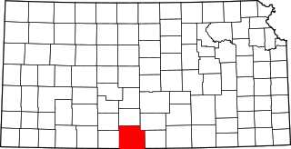
Barber County is a county located in the south-central portion of the U.S. state of Kansas. Its county seat and most populous city is Medicine Lodge. As of the 2020 census, the county population was 4,228. The county was named for Thomas Barber, an abolitionist who was killed in Douglas County in 1855 during the Wakarusa War.

<span class="mw-page-title-main">Altamont, Kansas</span> City in Labette County, Kansas

Altamont is a city in Labette County, Kansas, United States. As of the 2020 census, the population of the city was 1,061.

<span class="mw-page-title-main">Chetopa, Kansas</span> City in Labette County, Kansas

Chetopa is a city in Labette County, Kansas, United States. As of the 2020 census, the population of the city was 929. Chetopa was named for Chief Chetopah, an Osage Indian chief. Later, the community name was shortened.

<span class="mw-page-title-main">Labette, Kansas</span> City in Labette County, Kansas

Labette is a city in Labette County, Kansas, United States. As of the 2020 census, the population of the city was 50.

<span class="mw-page-title-main">Oswego, Kansas</span> City in Labette County, Kansas

Oswego is a city in and the county seat of Labette County, Kansas, United States, and situated along the Neosho River. As of the 2020 census, the population of the city was 1,668.

<span class="mw-page-title-main">Parsons, Kansas</span> City in Labette County, Kansas

Parsons is a city in Labette County, Kansas, United States. As of the 2020 census, the population of the city was 9,600. It is the most populous city of Labette County, and the second-most populous city in the southeastern region of Kansas. It is home to Labette Community College and the Parsons State Hospital & Training Center.

References

  1. 1 2 3 "QuickFacts; Labette County, Kansas; Population, Census, 2020 & 2010". United States Census Bureau. Archived from the original on August 18, 2021. Retrieved August 17, 2021.
  2. "Find a County". National Association of Counties. Retrieved June 7, 2011.
  3. "Labette Co History". Labette County, Kansas. 2013. Archived from the original on June 5, 2016. Retrieved May 9, 2016.
  4. 1 2 "Kansas Counties:Labette County, Kansas". Kansas Historical Society. Retrieved May 9, 2016.
  5. Nelson Case's history of Labette County, Kansas Archived July 7, 2009, at the Wayback Machine
  6. "Bender Knife". Kansas Historical Society. Retrieved May 6, 2016.
  7. Potter, Tim. "The Bloody Benders: 140-year-old crime scene still fascinates today". Wichita Eagle. August 24, 2013. Retrieved May 6, 2016.
  8. "US Gazetteer files: 2010, 2000, and 1990". United States Census Bureau. February 12, 2011. Retrieved April 23, 2011.
  9. "Annual Estimates of the Resident Population for Counties: April 1, 2020 to July 1, 2023". United States Census Bureau. Retrieved April 3, 2024.
  10. "U.S. Decennial Census". United States Census Bureau. Retrieved July 26, 2014.
  11. "Historical Census Browser". University of Virginia Library. Retrieved July 26, 2014.
  12. "Population of Counties by Decennial Census: 1900 to 1990". United States Census Bureau. Retrieved July 26, 2014.
  13. "Census 2000 PHC-T-4. Ranking Tables for Counties: 1990 and 2000" (PDF). United States Census Bureau. Archived (PDF) from the original on March 27, 2010. Retrieved July 26, 2014.
  14. 2010 census general population statistics on Labette County, Kansa]
  15. "U.S. Census website". United States Census Bureau . Retrieved January 31, 2008.
  16. "Dave Leip's Atlas of U.S. Presidential Elections".
  17. "Map of Wet and Dry Counties". Alcoholic Beverage Control, Kansas Department of Revenue. November 2006. Archived from the original on October 8, 2007. Retrieved December 26, 2007.
Notes

    Further reading

    County
    Historical
    Maps