1845 Santa Fe Trail crossing McPherson County1915–1918 railroad map of McPherson County
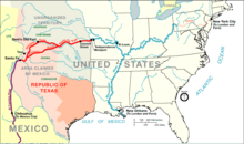
From the 1820s to 1870s, the Santa Fe Trail passed through, what is now McPherson County. The trail entered the county, east of Canton, then south of Galva, then north of Inman, and west towards Lyons. In 1855, Charles O. Fuller established a ranch adjacent to the Running Turkey Creek Crossing about two miles south and one mile east of Galva. Fuller's Ranch provided accommodations for travelers on the Santa Fe Trail and was probably the first white settlement in McPherson County.
Peketon County was established in 1860, by the passage of a bill by S. N. Wood: An act to establish Peketon County. Section 1. - That all that territory west of the sixth principal meridian and south of Township 16, in Kansas Territory, be and the same is hereby erected into a county, to be known by the name of Peketon County. On February 17, 1865, Peketon County was abolished, and McPherson County was made a part of Marion County, which extended from the west line of Chase County to the present western boundary of Kansas.
In 1868, Solomon Stephens and L. N. Holmberg were appointed Justices of the Peace—the first officers in what is now McPherson County. The next year (1869) occurred the first election for the township, now the county of McPherson. McPherson was regularly organized as a county in the spring of 1870, a mass meeting being held at Sweadal. Sweadal, the county seat thus selected, was located about one mile and a half southwest of the present site of Lindsborg. In September, however, the County Commissioners resolved to meet at the latter place, McPherson which had already been located some two years.
In April 1873, a petition was filed for the county seat re-location. It was signed by 483 voters, and a special election was accordingly ordered for June 10. Upon that day, McPherson received 605 votes, New Gottland 325, King City 3 and Lindsborg 1; McPherson's majority over all, 276. In May the McPherson Town Company had offered, as an inducement for the location of the county seat at this point, the free use of rooms for ten years, and the donation of two squares of land on the town site. The offer was accepted the next month, the County Commissioners selecting blocks 56 and 65. Thus the county seat was established at McPherson and has remained since.
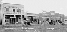
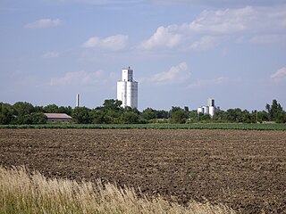
Windom, Kansas in McPherson County during the early 20th century
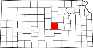
According to the U.S. Census Bureau, the county has a total area of 901 square miles (2,330km2), of which 898 square miles (2,330km2) is land and 2.3 square miles (6.0km2) (0.3%) is water.[8]
As of the census[14] of 2000, there were 29,554 people, 11,205 households, and 7,966 families residing in the county. The population density was 33 peopleper square mile (13 people/km2). There were 11,830 housing units at an average density of 13 per square mile (5.0/km2). The racial makeup of the county was 96.53% White, 0.81% Black or African American, 0.34% Native American, 0.32% Asian, 0.06% Pacific Islander, 0.79% from other races, and 1.16% from two or more races. 1.94% of the population were Hispanic or Latino of any race. 37.1% were of German, 12.9% Swedish, 12.1% American, 6.7% English and 6.3% Irish ancestry according to Census 2000.
There were 11,205 households, out of which 33.00% had children under the age of 18 living with them, 62.50% were married couples living together, 6.00% had a female householder with no husband present, and 28.90% were non-families. 25.50% of all households were made up of individuals, and 11.80% had someone living alone who was 65 years of age or older. The average household size was 2.49 and the average family size was 2.99.
In the county, the population was spread out, with 25.40% under the age of 18, 10.30% from 18 to 24, 25.20% from 25 to 44, 21.80% from 45 to 64, and 17.30% who were 65 years of age or older. The median age was 38 years. For every 100 females there were 95.90 males. For every 100 females age 18 and over, there were 92.90 males.
The median income for a household in the county was $41,138, and the median income for a family was $48,243. Males had a median income of $33,530 versus $21,175 for females. The per capita income for the county was $18,921. About 4.20% of families and 6.60% of the population were below the poverty line, including 5.20% of those under age 18 and 8.10% of those age 65 or over.
Government
Presidential elections
McPherson county is often carried by Republican candidates. The last time a Democratic candidate has carried this county was in 1964 by Lyndon B. Johnson.
Presidential election results
United States presidential election results for McPherson County, Kansas[15]
Following amendment to the Kansas Constitution in 1986, the county remained a prohibition, or "dry", county until 1996, when voters approved the sale of alcoholic liquor by the individual drink with a 30 percent food sales requirement.[16]
McPherson County is divided into twenty-five townships. The cities of Lindsborg and McPherson are considered governmentally independent and are excluded from the census figures for the townships. In the following table, the population center is the largest city (or cities) included in that township's population total, if it is of a significant size.
Rice County is a county located in the U.S. state of Kansas. Its county seat and largest city is Lyons. As of the 2020 census, the county population was 9,427. The county was named in memory of Samuel Allen Rice, Brigadier-General, United States volunteers, killed April 30, 1864, at Jenkins Ferry, Arkansas.
Reno County is a county located in the U.S. state of Kansas. Its county seat and largest city is Hutchinson. As of the 2020 census, the population was 61,898. The county is named for Jesse Reno, a general during the American Civil War.
Pratt County is a county located in the U.S. state of Kansas. Its county seat and largest city is Pratt. As of the 2020 census, the county population was 9,157. The county was named for Caleb Pratt, a U.S. soldier who died in the Battle of Wilson's Creek during the American Civil War and had previously been involved in Bleeding Kansas.
Morris County is a county located in the U.S. state of Kansas. Its county seat and largest city is Council Grove. As of the 2020 census, the county population was 5,386. The county was named for Thomas Morris, a U.S. Senator from Ohio and anti-slavery advocate.
Marion County is a county located in the U.S. state of Kansas. Its county seat is Marion and its most populous city is Hillsboro. As of the 2020 census, the county population was 11,823. The county was named in honor of Francis Marion, a brigadier general of the American Revolutionary War, known as the "Swamp Fox".
Harvey County is a county located in the U.S. state of Kansas. Its county seat and most populous city is Newton. As of the 2020 census, the county population was 34,024. The county was named for James Harvey, a U.S. senator and 5th governor of Kansas.
Dickinson County is a county in Central Kansas. Its county seat and most populous city is Abilene. As of the 2020 census, the county population was 18,402. The county was named in honor of Daniel Dickinson, a U.S. Senator from New York that was a Kansas statehood advocate.
Barton County is a county located in the U.S. state of Kansas. Its county seat and most populous city is Great Bend. As of the 2020 census, the county population was 25,493. The county is named in honor of Clara Barton, responsible for the founding of the American Red Cross, and the only county in Kansas to be named for a woman.
Ellinwood is a city in the southeast corner of Barton County, Kansas, United States. As of the 2020 census, the population of the city was 2,011.
Hillsboro is a city in Marion County, Kansas, United States. As of the 2020 census, the population of the city was 2,732. The city was named after John Hill, who homesteaded in the area in 1871. Hillsboro is home of Tabor College.
Lehigh is a city in Marion County, Kansas, United States. As of the 2020 census, the population of the city was 161. It is located between Hillsboro and Canton on the north side of U.S. Route 56.
Canton is a city in McPherson County, Kansas, United States. As of the 2020 census, the population of the city was 685. It is named after Canton, Ohio.
Galva is a city in McPherson County, Kansas, United States. As of the 2020 census, the population of the city was 834.
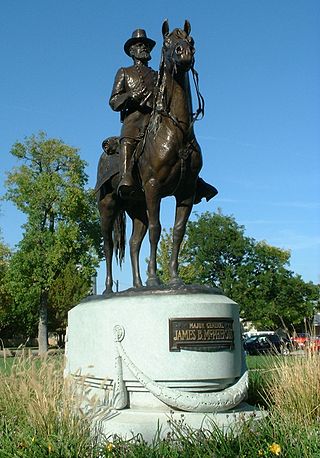
McPherson is a city in and the county seat of McPherson County, Kansas, United States. As of the 2020 census, the population of the city was 14,082. The city is named after Union General James Birdseye McPherson, a Civil War general. It is home to McPherson College and Central Christian College.
Windom is a city in McPherson County, Kansas, United States. As of the 2020 census, the population of the city was 85.
Chase is a city in Rice County, Kansas, United States. As of the 2020 census, the population of the city was 396.
Little River is a city in Rice County, Kansas, United States. As of the 2020 census, the population of the city was 472.
Mitchell is an unincorporated community in Rice County, Kansas, United States. Located about 6 miles (9.7 km) east-northeast of the city of Lyons, it lies along local roads a fraction of a mile north of U.S. Route 56.
Conway is an unincorporated community in southwestern Jackson Township, McPherson County, Kansas, United States. It lies along U.S. Route 56 and a Kansas and Oklahoma Railroad line, west of the city of McPherson.
Canada is an unincorporated community in Marion County, Kansas, United States. It is named for many Canadian immigrants coming to the area. It is located between Hillsboro and Marion about 0.5 miles south of the intersection of Nighthawk Road and U.S. Route 56 highway, southwest of the Hillsboro Cove of the Marion Reservoir.
↑ "Map of Wet and Dry Counties". Alcoholic Beverage Control, Kansas Department of Revenue. November 2006. Archived from the original on October 8, 2007. Retrieved December 26, 2007.
Wheeler, Wayne Leland. "An Analysis of Social Change in a Swedish-Immigrant Community: The Case of Lindsborg, Kansas." (PhD dissertation, University of Missouri-Columbia; ProQuest Dissertations Publishing, 1959. 5905657).
County
Through the Years: A Pictorial History of McPherson County; McPherson Sentinel' Heritage House Publishing Co; 1992.
McPherson County First Courthouse Built About 1869 or 1870; Lindsborg News-Record; March 30, 1959.
Pioneer Life and Lore of McPherson County, Kansas; Edna Nyquist; Democratic-Opinion Press; 1932.
This page is based on this Wikipedia article Text is available under the CC BY-SA 4.0 license; additional terms may apply. Images, videos and audio are available under their respective licenses.