Cowley County, Kansas

Last updated

Cowley County
Cowley County National Bank Building.JPG
Map of Kansas highlighting Cowley County.svg
Location within the U.S. state of Kansas
Kansas in United States.svg
Kansas's location within the U.S.
Coordinates: 37°14′N96°50′W / 37.233°N 96.833°W / 37.233; -96.833
CountryFlag of the United States.svg United States
StateFlag of Kansas.svg  Kansas
FoundedFebruary 26, 1867
Named for Matthew Cowley
Seat Winfield
Largest city Arkansas City
Area
  Total1,132 sq mi (2,930 km2)
  Land1,126 sq mi (2,920 km2)
  Water6.7 sq mi (17 km2)  0.6%
Population
 (2020) [1]
  Total34,549
  Density30.7/sq mi (11.9/km2)
Time zone UTC−6 (Central)
  Summer (DST) UTC−5 (CDT)
Area code 620
Congressional district 4th
Website cowleycounty.org

Cowley County is a county located in the U.S. state of Kansas. Its county seat is Winfield, [2] and its most populous city is Arkansas City. As of the 2020 census, the county population was 34,549. [1] The county was named after Matthew Cowley, first lieutenant in Company I, 9th Kansas Cavalry, who died during the American Civil War.

Contents

History

For millennia, the land now known as Kansas was inhabited by Native Americans. The first European visitor to Kansas was the Spanish explorer Francisco Vasquez de Coronado in 1541. In 1601, the Governor of New Mexico, Juan de Oñate, visited Etzanoa, a settlement of several thousand Wichita people near Arkansas City along the Walnut River. The ruins of Etzanoa have been found by archaeologists.

19th century

In 1803, most of modern Kansas was secured by the United States as part of the Louisiana Purchase. In 1854, the Kansas Territory was organized, then in 1861 Kansas became the 34th U.S. state. Cowley County was officially organized as a county, but reserved for the Osage Indians, by the Kansas Legislature in March 1867, originally named Hunter County for Robert Mercer Taliaferro Hunter (1809–1887), a Virginia Representative and Senator to Congress and Speaker of the House in the twenty-sixth Congress. In 1870, the county was renamed for Matthew Cowley, First Lieutenant in Company I, 9th Kansas Cavalry, who died at Little Rock, Arkansas, on October 7, 1864. Officially opened for settlement July 15, 1870, there was a lengthy and bitter disagreement between the towns of Winfield and Cresswell (the town now named Arkansas City) over the possession of the county seat of government. Finally settled after two special elections and numerous petitions to the Governor and Legislature, Winfield was determined to be the county seat and a courthouse was constructed in 1873 at a cost of $11,500. [3]

21st century

In 2010, the Keystone-Cushing Pipeline (Phase II) was constructed north to south through Cowley County. Controversy arose from the Kansas legislature's decision to grant the pipeline a ten-year exemption from property taxes; it was estimated that this would mean $15 million per year in lost revenue to the six counties through which the pipeline passed. The counties were unsuccessful in an attempt to eliminate the exemption. [4] [5] [6] [7]

Geography

According to the U.S. Census Bureau, the county has a total area of 1,132 square miles (2,930 km2), of which 1,126 square miles (2,920 km2) is land and 6.7 square miles (17 km2) (0.6%) is water. [8]

Waterfall located in the Cowley County Fishing Lake - Year 2016 Waterfall in Cowley County in 2016.jpg
Waterfall located in the Cowley County Fishing Lake - Year 2016

West of Dexter, KS, Cowley County Fishing Lake is positioned just off of Highway 166. This fishing lake is the home of the Cowley County Waterfall, which can be visited following the road to the northwest side of the property. [9] However, in recent years (as of 2021) the severe drought has caused the waterfall to stop flowing. It will likely continue if the area receives enough precipitation and ends the drought.

Waterfall (Currently not flowing) located in the Cowley County Fishing Lake - Year 2023 Waterfall in Cowley County in 2023.jpg
Waterfall (Currently not flowing) located in the Cowley County Fishing Lake - Year 2023

Adjacent counties

Demographics

Population pyramid based on 2000 census age data USA Cowley County, Kansas age pyramid.svg
Population pyramid based on 2000 census age data
Historical population
CensusPop.Note
1860 158
1870 1,175643.7%
1880 21,5381,733.0%
1890 34,47860.1%
1900 30,156−12.5%
1910 31,7905.4%
1920 35,15510.6%
1930 40,90316.4%
1940 38,139−6.8%
1950 36,905−3.2%
1960 37,8612.6%
1970 35,012−7.5%
1980 36,8245.2%
1990 36,9150.2%
2000 36,291−1.7%
2010 36,3110.1%
2020 34,549−4.9%
2023 (est.)34,157 [10] −1.1%
U.S. Decennial Census [11]
1790-1960 [12] 1900-1990 [13]
1990-2000 [14] 2010-2020 [1]

Cowley County comprises the Arkansas City-Winfield, KS Micropolitan Statistical Area, which is included in the Wichita-Arkansas City-Winfield, KS Combined Statistical Area.

As of the U.S. Census in 2000, [15] there were 36,291 people, 14,039 households, and 9,616 families residing in the county. The population density was 32 inhabitants per square mile (12/km2). There were 15,673 housing units at an average density of 14 per square mile (5.4/km2). The racial makeup of the county was 90.13% White, 2.70% Black or African American, 1.96% Native American, 1.53% Asian, 0.01% Pacific Islander, 1.36% from other races, and 2.30% from two or more races. Hispanic or Latino of any race were 3.59% of the population.

There were 14,039 households, out of which 32.20% had children under the age of 18 living with them, 55.20% were married couples living together, 9.60% had a female householder with no husband present, and 31.50% were non-families. 27.90% of all households were made up of individuals, and 13.20% had someone living alone who was 65 years of age or older. The average household size was 2.46 and the average family size was 3.00.

In the county, the population was spread out, with 26.00% under the age of 18, 9.90% from 18 to 24, 26.00% from 25 to 44, 22.20% from 45 to 64, and 15.90% who were 65 years of age or older. The median age was 37 years. For every 100 females, there were 95.70 males. For every 100 females age 18 and over, there were 94.20 males.

The median income for a household in the county was $34,406, and the median income for a family was $43,636. Males had a median income of $31,703 versus $21,341 for females. The per capita income for the county was $17,509. About 9.20% of families and 12.90% of the population were below the poverty line, including 17.00% of those under age 18 and 11.20% of those age 65 or over.

Government

Presidential elections

Presidential election results
United States presidential election results for Cowley County, Kansas [16]
Year Republican Democratic Third party
No.%No.%No.%
2020 9,65667.85%4,27330.03%3022.12%
2016 8,27065.53%3,55128.14%8006.34%
2012 8,08163.58%4,31933.98%3102.44%
2008 8,49261.59%5,01236.35%2832.05%
2004 9,40765.11%4,81833.35%2221.54%
2000 8,08056.86%5,53538.95%5954.19%
1996 7,87250.79%5,58836.05%2,03913.16%
1992 5,42234.35%5,40534.24%4,95731.41%
1988 7,77854.44%6,18643.30%3222.25%
1984 10,00864.99%5,19333.72%1981.29%
1980 8,74957.14%5,47435.75%1,0897.11%
1976 7,51350.32%7,09547.52%3232.16%
1972 10,33270.51%3,59224.51%7294.98%
1968 8,07054.30%5,01433.74%1,77711.96%
1964 7,09247.93%7,59151.30%1140.77%
1960 10,27661.98%6,20537.42%990.60%
1956 6,73463.93%3,75335.63%460.44%
1952 11,45468.13%5,24231.18%1160.69%
1948 8,10252.13%7,04245.31%3972.55%
1944 8,45355.91%6,57743.50%900.60%
1940 9,68453.99%8,11545.25%1360.76%
1936 8,37843.51%10,80556.12%720.37%
1932 7,65744.71%8,68150.69%7884.60%
1928 12,70180.79%2,81817.93%2021.28%
1924 8,52958.51%3,16121.68%2,88719.81%
1920 7,35259.22%4,73338.13%3292.65%
1916 5,29743.87%5,96249.37%8166.76%
1912 1,11315.75%2,53935.93%3,41448.32%
1908 2,57842.42%2,99549.28%5058.31%
1904 3,96161.33%1,45622.54%1,04216.13%
1900 3,67950.47%3,43647.14%1742.39%
1896 2,87145.14%3,41053.62%791.24%
1892 3,88649.13%00.00%4,02350.87%
1888 4,11253.41%1,93325.11%1,65421.48%

Laws

Following amendment to the Kansas Constitution in 1986, the county remained a prohibition, or "dry", county until 1996, when voters approved the sale of alcoholic liquor by the individual drink without a food sales requirement. [17]

The county voted "No" on the 2022 Kansas Value Them Both Amendment, an anti-abortion ballot measure, by 52% to 48% despite backing Donald Trump with 68% of the vote to Joe Biden's 30% in the 2020 presidential election. [18]

Education

Colleges

Unified school districts

Communities

2005 map of Cowley County (map legend) Map of Cowley Co, Ks, USA.png
2005 map of Cowley County (map legend)

List of townships / incorporated cities / unincorporated communities / extinct former communities within Cowley County. [19]

Cities

‡ means a community has portions in an adjacent county.

Unincorporated communities

† means a community is designated a Census-Designated Place (CDP) by the United States Census Bureau.

Ghost towns

Townships

Cowley County is divided into twenty-five townships. The cities of Arkansas City and Winfield are considered governmentally independent and are excluded from the census figures for the townships. In the following table, the population center is the largest city (or cities) included in that township's population total, if it is of a significant size.

Township FIPS Population
center
PopulationPopulation
density
/km2 (/sq mi)
Land area
km2 (sq mi)
Water area
km2 (sq mi)
Water %Geographic coordinates
Beaver 050252443 (7)92 (36)2 (1)1.91% 37°10′42″N97°5′26″W / 37.17833°N 97.09056°W / 37.17833; -97.09056
Bolton 078751,75413 (33)136 (53)2 (1)1.59% 37°3′1″N97°4′0″W / 37.05028°N 97.06667°W / 37.05028; -97.06667
Cedar 11250440 (1)119 (46)1 (0)0.45% 37°5′9″N96°36′27″W / 37.08583°N 96.60750°W / 37.08583; -96.60750
Creswell 163752,09822 (56)97 (38)2 (1)2.07% 37°4′42″N97°1′3″W / 37.07833°N 97.01750°W / 37.07833; -97.01750
Dexter 179505063 (7)185 (71)0 (0)0.19% 37°11′56″N96°42′27″W / 37.19889°N 96.70750°W / 37.19889; -96.70750
Fairview 224752032 (6)93 (36)0 (0)0.29% 37°21′22″N96°58′50″W / 37.35611°N 96.98056°W / 37.35611; -96.98056
Grant 27550761 (2)116 (45)0 (0)0.09% 37°3′49″N96°41′3″W / 37.06361°N 96.68417°W / 37.06361; -96.68417
Harvey 305251171 (2)162 (63)0 (0)0.24% 37°26′47″N96°37′58″W / 37.44639°N 96.63278°W / 37.44639; -96.63278
Liberty 399502182 (5)124 (48)0 (0)0.02% 37°9′3″N96°50′31″W / 37.15083°N 96.84194°W / 37.15083; -96.84194
Maple 444507028 (20)91 (35)0 (0)0% 37°25′59″N97°6′7″W / 37.43306°N 97.10194°W / 37.43306; -97.10194
Ninnescah 506251,11412 (31)93 (36)0 (0)0.09% 37°21′59″N97°6′21″W / 37.36639°N 97.10583°W / 37.36639; -97.10583
Omnia 528503574 (10)93 (36)0 (0)0.22% 37°26′13″N96°46′25″W / 37.43694°N 96.77361°W / 37.43694; -96.77361
Otter 53625540 (1)135 (52)1 (0)0.68% 37°11′25″N96°33′0″W / 37.19028°N 96.55000°W / 37.19028; -96.55000
Pleasant Valley 565008387 (18)117 (45)0 (0)0.05% 37°9′45″N97°0′0″W / 37.16250°N 97.00000°W / 37.16250; -97.00000
Richland 592751782 (4)108 (42)0 (0)0% 37°25′33″N96°52′50″W / 37.42583°N 96.88056°W / 37.42583; -96.88056
Rock Creek 605252433 (7)92 (35)1 (0)0.55% 37°26′5″N96°59′25″W / 37.43472°N 96.99028°W / 37.43472; -96.99028
Salem 626253645 (14)66 (26)0 (0)0.27% 37°20′9″N96°53′20″W / 37.33583°N 96.88889°W / 37.33583; -96.88889
Sheridan 646501592 (4)93 (36)0 (0)0.01% 37°15′44″N96°45′51″W / 37.26222°N 96.76417°W / 37.26222; -96.76417
Silver Creek 655007708 (21)93 (36)0 (0)0.27% 37°20′8″N96°45′41″W / 37.33556°N 96.76139°W / 37.33556; -96.76139
Silverdale 65575 Silverdale 3272 (6)136 (53)0 (0)0.31% 37°3′55″N96°52′56″W / 37.06528°N 96.88222°W / 37.06528; -96.88222
Spring Creek 67400771 (2)115 (45)0 (0)0.26% 37°4′31″N96°47′10″W / 37.07528°N 96.78611°W / 37.07528; -96.78611
Tisdale 707253404 (11)78 (30)0 (0)0.13% 37°16′6″N96°52′25″W / 37.26833°N 96.87361°W / 37.26833; -96.87361
Vernon 735755025 (13)102 (39)1 (0)0.67% 37°15′25″N97°5′18″W / 37.25694°N 97.08833°W / 37.25694; -97.08833
Walnut 749256267 (18)89 (34)0 (0)0.18% 37°15′17″N96°57′27″W / 37.25472°N 96.95750°W / 37.25472; -96.95750
Windsor 798752111 (2)243 (94)0 (0)0.18% 37°19′13″N96°38′22″W / 37.32028°N 96.63944°W / 37.32028; -96.63944
Sources: "Census 2000 U.S. Gazetteer Files". U.S. Census Bureau, Geography Division. Archived from the original on August 2, 2002.

Notable people

See List of people from Cowley County, Kansas

General Dean Coldwell Strother was a United States Air Force four-star general who served as U.S. Military Representative, NATO Military Committee (USMILREP), from 1962 to 1965; and as Commander in Chief, North American Air Defense Command/Commander in Chief, Continental Air Defense Command (CINCNORAD/CINCONAD), from 1965 to 1966.

Robert Docking was a successful banker and mayor of Arkansas City before he became the 38th Governor of Kansas.

Several college football head coaches have passed through Winfield that have gone on to become widely recognized. Jerry Kill is the current head coach for the Minnesota Golden Gophers—he played for the Southwestern Moundbuilders under Dennis Franchione when he was head coach. Jack Mitchell went on to coach several schools including the Kansas Jayhawks. Former head coach and for the Oklahoma Sooners and College Football Hall of Fame member Bennie Owen was born in Arkansas City.

Perhaps the most famous resident of Cowley County is the fictional character Mary Ann Summers from the television show Gilligan's Island . It is said on the show that she is "employed at the Winfield General Store."

See also

Community information for Kansas

Related Research Articles

<span class="mw-page-title-main">Clay County, Kansas</span> County in Kansas, United States

Clay County is a county located in the U.S. state of Kansas. Its county seat and most populous city is Clay Center. As of the 2020 census, the county population was 8,117. The county was named for Henry Clay, an influential U.S. Senator from Kentucky.

<span class="mw-page-title-main">Montgomery County, Kansas</span> County in Kansas, United States

Montgomery County is a county located in Southeast Kansas. Its county seat is Independence, and its most populous city is Coffeyville. As of the 2020 census, the county population was 31,486. The county was named after Richard Montgomery, a major general during the American Revolutionary War.

<span class="mw-page-title-main">Washington County, Kansas</span> County in Kansas, United States

Washington County is a county located in the U.S. state of Kansas. Its county seat and largest city is Washington. As of the 2020 census, the county population was 5,530. The county was named for George Washington, the 1st president of the United States.

<span class="mw-page-title-main">Stevens County, Kansas</span> County in Kansas, United States

Stevens County is a county located in the U.S. state of Kansas. Its county seat is Hugoton. As of the 2020 census, the county population was 5,250. The county is named for Thaddeus Stevens, a Reconstruction era Pennsylvania politician.

<span class="mw-page-title-main">Stafford County, Kansas</span> County in Kansas, United States

Stafford County is a county located in the U.S. state of Kansas. Its county seat is St. John. As of the 2020 census, the county population was 4,072. The county is named in honor of Lewis Stafford, a captain of Company E, First Kansas Infantry, who died at the Battle of Young's Point during the American Civil War.

<span class="mw-page-title-main">Neosho County, Kansas</span> County in Kansas, United States

Neosho County is a county located in Southeast Kansas. Its county seat is Erie. As of the 2020 census, the county population was 15,904. The county was named for the Neosho River, which passes through the county.

<span class="mw-page-title-main">Nemaha County, Kansas</span> County in Kansas, United States

Nemaha County is a county located in the northeastern part of the U.S. state of Kansas. Its county seat is Seneca. As of the 2020 census, the county population was 10,273. The county was named for the Nemaha River.

<span class="mw-page-title-main">Linn County, Kansas</span> County in Kansas, United States

Linn County is a county in the U.S. state of Kansas, located in along the eastern edge of Kansas, and is part of the Kansas City metropolitan area. Its county seat is Mound City, and its most populous city is Pleasanton. As of the 2020 census, the county population was 9,591. The county was named for Lewis Linn, a U.S. Senator from Missouri.

<span class="mw-page-title-main">Kingman County, Kansas</span> County in Kansas, United States

Kingman County is a county located in the U.S. state of Kansas. Its county seat and largest city is Kingman. As of the 2020 census, the county population was 7,470. The county was named for Samuel Kingman, a chief justice of the Kansas Supreme Court during the 1860s and 1870s.

<span class="mw-page-title-main">Greenwood County, Kansas</span> County in Kansas, United States

Greenwood County is a county located in the southeast portion of the U.S. state of Kansas. Its county seat and most populous city is Eureka. As of the 2020 census, the county population was 6,016. The county was named for Alfred Greenwood, a U.S. congressman from Arkansas that advocated Kansas statehood.

<span class="mw-page-title-main">Elk County, Kansas</span> County in Kansas, United States

Elk County is a county located in the U.S. state of Kansas. Its county seat and most populous city is Howard. As of the 2020 census, the county population was 2,483. The county was named for the Elk River.

<span class="mw-page-title-main">Edwards County, Kansas</span> County in Kansas, United States

Edwards County is a county located in the U.S. states of Kansas. Its county seat and most populous city is Kinsley. As of the 2020 census, the county population was 2,907, The county was founded in 1874 and named for W. C. Edwards, of Hutchinson, a pioneer settler who owned much land in the area.

<span class="mw-page-title-main">Comanche County, Kansas</span> County in Kansas, United States

Comanche County is a county located in the U.S. state of Kansas. Its county seat and most populous city is Coldwater. As of the 2020 census, the county population was 1,689. The county was named after the Comanche tribe.

<span class="mw-page-title-main">Coffey County, Kansas</span> County in Kansas, United States

Coffey County is a county located in Eastern Kansas. Its county seat and most populous city is Burlington. As of the 2020 census, the county population was 8,360. It was named after A.M. Coffey, a territorial legislator and Free-Stater during Bleeding Kansas era.

<span class="mw-page-title-main">Clark County, Kansas</span> County in Kansas, United States

Clark County is a county located in the U.S. state of Kansas. Its county seat and most populous city is Ashland. As of the 2020 census, the county population was 1,991. The county was named after Charles Clarke.

<span class="mw-page-title-main">Butler County, Kansas</span> County in Kansas, United States

Butler County is a county in the U.S. state of Kansas and is the largest county in the state by total area. Its county seat is El Dorado and its most populous city is Andover. As of the 2020 census, the county population was 67,380. The county was named for Andrew Butler, a U.S. Senator from South Carolina who coauthored the Kansas–Nebraska Act.

<span class="mw-page-title-main">Atchison County, Kansas</span> County in Kansas, United States

Atchison County is a county located in the northeast portion of the U.S. state of Kansas. Its county seat and most populous city is Atchison. As of the 2020 census, the county population was 16,348. The county was named in honor of David Atchison, a U.S. Senator from Missouri and border ruffian during the "Bleeding Kansas" era.

<span class="mw-page-title-main">Arkansas City, Kansas</span> City in Cowley County, Kansas

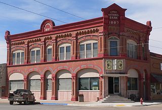
Arkansas City is a city in Cowley County, Kansas, United States, situated at the confluence of the Arkansas River and Walnut River in the southwestern part of the county. As of the 2020 census, the population of the city was 11,974.

<span class="mw-page-title-main">Winfield, Kansas</span> City in Cowley County, Kansas

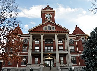
Winfield is a city and county seat of Cowley County, Kansas, United States. It is situated along the Walnut River in South Central Kansas. As of the 2020 census, the population of the city was 11,777. It is home to Southwestern College.

<span class="mw-page-title-main">Rock, Kansas</span> Unincorporated community in Cowley County, Kansas

Rock is an unincorporated community in Cowley County, Kansas, United States. As of the 2020 census, the population of the community and nearby areas was 94.

References

  1. 1 2 3 "QuickFacts; Cowley County, Kansas; Population, Census, 2020 & 2010". United States Census Bureau. Archived from the original on August 16, 2021. Retrieved August 15, 2021.
  2. "Find a County". National Association of Counties. Archived from the original on May 31, 2011. Retrieved June 7, 2011.
  3. "William G. Cutler's, History of the State of Kansas". A. T. Andreas Press, 1883.[ permanent dead link ]
  4. Davis, Dakotah. "Commissioners green light pipeline, sort of". Archived June 3, 2016, at the Wayback Machine NewsCow.net. Archived May 3, 2016, at the Wayback Machine May 19, 2010. Retrieved May 1, 2016.
  5. "Counties to seek denial of pipeline tax exemption". Clay Center Dispatch. November 5, 2009. Archived December 16, 2009.
  6. "Court upholds pipeline tax exemption". Topeka Capital-Journal. May 18, 2012. Retrieved May 1, 2016.
  7. Milburn, John. "Kansas appeals court upholds Keystone pipeline tax ruling". Kansas City Star. April 26, 2013. Retrieved May 1, 2016.
  8. "US Gazetteer files: 2010, 2000, and 1990". United States Census Bureau. February 12, 2011. Retrieved April 23, 2011.
  9. "Cowley County, Kansas - Cowley County Waterfall". www.cowleycountyks.gov. Retrieved September 3, 2023.
  10. "Annual Estimates of the Resident Population for Counties: April 1, 2020 to July 1, 2023". United States Census Bureau. Retrieved April 3, 2024.
  11. "U.S. Decennial Census". United States Census Bureau. Retrieved July 22, 2014.
  12. "Historical Census Browser". University of Virginia Library. Archived from the original on August 11, 2012. Retrieved July 22, 2014.
  13. "Population of Counties by Decennial Census: 1900 to 1990". United States Census Bureau. Retrieved July 22, 2014.
  14. "Census 2000 PHC-T-4. Ranking Tables for Counties: 1990 and 2000" (PDF). United States Census Bureau. Archived (PDF) from the original on March 27, 2010. Retrieved July 22, 2014.
  15. "U.S. Census website". United States Census Bureau . Retrieved January 31, 2008.
  16. "Dave Leip's Atlas of U.S. Presidential Elections".
  17. "Map of Wet and Dry Counties". Alcoholic Beverage Control, Kansas Department of Revenue. November 2006. Archived from the original on February 19, 2008. Retrieved December 28, 2007.
  18. Panetta, Grace (August 3, 2022). "14 of the 19 Kansas counties that rejected an anti-abortion amendment voted for Trump in 2020". Business Insider. Retrieved August 3, 2022.
  19. 1 2 "General Highway Map of Cowley County, Kansas" (PDF). Kansas Department of Transportation (KDOT). March 2011. Archived (PDF) from the original on August 7, 2023.
Notes

    Further reading

    County
    Historical
    Maps