Trego County, Kansas

Last updated

Trego County
Trego County Courthouse - west face 20171012 142952.jpg
Trego County Courthouse in WaKeeney (2017)
Map of Kansas highlighting Trego County.svg
Location within the U.S. state of Kansas
Kansas in United States.svg
Kansas's location within the U.S.
Coordinates: 39°00′30″N100°03′54″W / 39.0083°N 100.065°W / 39.0083; -100.065
CountryFlag of the United States.svg United States
StateFlag of Kansas.svg  Kansas
FoundedJune 21, 1879
Named for Edgar Poe Trego [1]
Seat WaKeeney
Largest cityWaKeeney
Area
  Total900 sq mi (2,000 km2)
  Land889 sq mi (2,300 km2)
  Water10 sq mi (30 km2)  1.1%
Population
 (2020) [2]
  Total2,808
  Density3.2/sq mi (1.2/km2)
Time zone UTC−6 (Central)
  Summer (DST) UTC−5 (CDT)
Congressional district 1st
Website TregoCountyKS.com

Trego County is a county located in the U.S. state of Kansas. Its county seat and largest city is WaKeeney. [3] As of the 2020 census, the county population was 2,808. [2] The county was named for Edgar Trego.

Contents

History

Early history

For many millennia, the Great Plains of North America was inhabited by nomadic Native Americans. From the 16th century to 18th century, the Kingdom of France claimed ownership of large parts of North America. In 1762, after the French and Indian War, France secretly ceded New France to Spain, per the Treaty of Fontainebleau.

19th century

In 1802, Spain returned most of the land to France, but keeping title to about 7,500 square miles. In 1803, most of the land for modern day Kansas was acquired by the United States from France as part of the 828,000 square mile Louisiana Purchase for 2.83 cents per acre.

In 1854, the Kansas Territory was organized, then in 1861 Kansas became the 34th U.S. state. In 1879, Trego County was established.

Geography

According to the U.S. Census Bureau, the county has a total area of 900 square miles (2,300 km2), of which 889 square miles (2,300 km2) is land and 10 square miles (26 km2) (1.1%) is water. [4]

Adjacent counties

Major highways

Demographics

Population pyramid based on 2000 census age data USA Trego County, Kansas age pyramid.svg
Population pyramid based on 2000 census age data
Historical population
CensusPop.Note
1870 166
1880 2,5351,427.1%
1890 2,5350.0%
1900 2,7227.4%
1910 5,39898.3%
1920 5,8808.9%
1930 6,47010.0%
1940 5,822−10.0%
1950 5,8680.8%
1960 5,473−6.7%
1970 4,436−18.9%
1980 4,165−6.1%
1990 3,694−11.3%
2000 3,319−10.2%
2010 3,001−9.6%
2020 2,808−6.4%
2023 (est.)2,731 [5] −2.7%
U.S. Decennial Census [6]
1790-1960 [7] 1900-1990 [8]
1990-2000 [9] 2010-2020 [2]

As of the census [10] of 2000, there were 3,319 people, 1,412 households, and 936 families residing in the county. The population density was 4 people per square mile (1.5 people/km2). There were 1,723 housing units at an average density of 2 per square mile (0.77/km2). The racial makeup of the county was 97.77% White, 0.18% Black or African American, 0.39% Native American, 0.48% Asian, 0.06% Pacific Islander, 0.15% from other races, and 0.96% from two or more races. 0.78% of the population were Hispanic or Latino of any race.

There were 1,412 households, out of which 27.30% had children under the age of 18 living with them, 58.10% were married couples living together, 6.30% had a female householder with no husband present, and 33.70% were non-families. 31.40% of all households were made up of individuals, and 17.70% had someone living alone who was 65 years of age or older. The average household size was 2.27 and the average family size was 2.86.

In the county, the population was spread out, with 23.90% under the age of 18, 5.50% from 18 to 24, 23.50% from 25 to 44, 23.20% from 45 to 64, and 24.00% who were 65 years of age or older. The median age was 44 years. For every 100 females there were 91.10 males. For every 100 females age 18 and over, there were 87.60 males.

The median income for a household in the county was $29,677, and the median income for a family was $40,524. Males had a median income of $26,545 versus $16,927 for females. The per capita income for the county was $16,239. About 11.20% of families and 12.30% of the population were below the poverty line, including 14.10% of those under age 18 and 12.00% of those age 65 or over.

Government

Presidential elections

Trego County is often carried by Republican candidates. The last time a Democratic candidate has carried this county was in 1964. The county has generally voted for Republican candidates by a larger margin by each passing election.

Presidential election results
United States presidential election results for Trego County, Kansas [11]
Year Republican Democratic Third party
No.%No.%No.%
2020 1,36383.62%24214.85%251.53%
2016 1,22782.79%19813.36%573.85%
2012 1,26179.86%29118.43%271.71%
2008 1,22573.31%42025.13%261.56%
2004 1,22572.66%43425.74%271.60%
2000 1,22066.41%51628.09%1015.50%
1996 1,20561.11%54827.79%21911.11%
1992 72738.02%60831.80%57730.18%
1988 97953.47%79543.42%573.11%
1984 1,49170.40%59828.23%291.37%
1980 1,34065.43%52325.54%1859.03%
1976 1,02549.56%1,00348.50%401.93%
1972 1,36966.91%62130.35%562.74%
1968 1,21158.67%62330.18%23011.14%
1964 97445.05%1,17754.44%110.51%
1960 1,42661.76%87537.90%80.35%
1956 1,66869.41%72630.21%90.37%
1952 1,91575.60%60824.00%100.39%
1948 1,23751.82%1,11746.80%331.38%
1944 1,45961.98%88337.51%120.51%
1940 1,57157.59%1,14041.79%170.62%
1936 1,01236.00%1,78363.43%160.57%
1932 91833.76%1,75164.40%501.84%
1928 1,35957.73%98241.72%130.55%
1924 1,12158.14%39920.70%40821.16%
1920 1,29975.04%39522.82%372.14%
1916 86742.07%1,09453.08%1004.85%
1912 16014.34%44940.23%50745.43%
1908 61754.75%45840.64%524.61%
1904 52660.81%26430.52%758.67%
1900 36048.39%36148.52%233.09%
1896 25642.74%34056.76%30.50%
1892 30950.49%00.00%30349.51%
1888 47763.86%22029.45%506.69%

Laws

Trego County was a prohibition, or "dry", county until the Kansas Constitution was amended in 1986 and voters approved the sale of alcoholic liquor by the individual drink with a 30 percent food sales requirement. [12]

Education

Unified school districts

Communities

2005 map of Trego County (map legend) Map of Trego Co, Ks, USA.png
2005 map of Trego County (map legend)

List of townships / incorporated cities / unincorporated communities / extinct former communities within Trego County. [13]
† means a community is designated a Census-Designated Place (CDP) by the United States Census Bureau.

Cities

Unincorporated communities

Ghost towns

Townships

Trego County is divided into seven townships. None of the cities within the county are considered governmentally independent, and all figures for the townships include those of the cities. In the following table, the population center is the largest city (or cities) included in that township's population total, if it is of a significant size.

Sources: 2000 U.S. Gazetteer from the U.S. Census Bureau.
Township FIPS Population
center
PopulationPopulation
density
/km2 (/sq mi)
Land area
km2 (sq mi)
Water area
km2 (sq mi)
Water %Geographic coordinates
Collyer149253681 (2)517 (200)0 (0)0.02% 39°0′31″N100°3′55″W / 39.00861°N 100.06528°W / 39.00861; -100.06528
Franklin24500600 (1)259 (100)0 (0)0% 38°45′42″N100°4′10″W / 38.76167°N 100.06944°W / 38.76167; -100.06944
Glencoe26425701 (2)93 (36)0 (0)0% 38°55′40″N99°38′30″W / 38.92778°N 99.64167°W / 38.92778; -99.64167
Ogallah522502141 (1)373 (144)0 (0)0.05% 39°0′31″N99°41′49″W / 39.00861°N 99.69694°W / 39.00861; -99.69694
Riverside601501170 (1)296 (114)15 (6)4.95% 38°47′32″N99°42′41″W / 38.79222°N 99.71139°W / 38.79222; -99.71139
WaKeeney744752,3985 (13)465 (179)0 (0)0.03% 39°0′41″N99°52′36″W / 39.01139°N 99.87667°W / 39.01139; -99.87667
Wilcox79137920 (1)298 (115)12 (5)3.85% 38°47′25″N99°52′37″W / 38.79028°N 99.87694°W / 38.79028; -99.87694

Former towns and settlements in the county include Wilcox.

See also

Community information for Kansas

Related Research Articles

<span class="mw-page-title-main">Thomas County, Kansas</span> County in Kansas, United States

Thomas County is a county located in the U.S. state of Kansas. Its county seat is Colby. As of the 2020 census, the county population was 7,930. The county was named after George Thomas, a general during the American Civil War.

<span class="mw-page-title-main">Stanton County, Kansas</span> County in Kansas, United States

Stanton County is a county located in the U.S. state of Kansas. Its county seat is Johnson City. As of the 2020 census, the county population was 2,084. It was named for Edwin Stanton, the U.S. Secretary of War during most of the American Civil War.

<span class="mw-page-title-main">Sherman County, Kansas</span> County in Kansas, United States

Sherman County is a county located in the U.S. state of Kansas. Its county seat is Goodland. As of the 2020 census, the county population was 5,927. Sherman County was created by the Legislature of 1873, and named after general William Sherman, a general during the American Civil War.

<span class="mw-page-title-main">Rush County, Kansas</span> County in Kansas, United States

Rush County is a county located in the U.S. state of Kansas. Its county seat and largest city is La Crosse. As of the 2020 census, the county population was 2,956. The county was named for Alexander Rush.

<span class="mw-page-title-main">Rooks County, Kansas</span> County in Kansas, United States

Rooks County is a county located in the U.S. state of Kansas. Its county seat is Stockton, and its largest city is Plainville. As of the 2020 census, the county population was 4,919. The county was named for John Rooks, a private in Company I of the 11th Kansas Cavalry Regiment, who died at the Battle of Prairie Grove during the American Civil War.

<span class="mw-page-title-main">Rawlins County, Kansas</span> County in Kansas, United States

Rawlins County is a county located in the U.S. state of Kansas. Its county seat and largest city is Atwood. As of the 2020 census, the county population was 2,561. It was named after John Rawlins, a general in the American Civil War.

<span class="mw-page-title-main">Phillips County, Kansas</span> County in Kansas, United States

Phillips County is a county located in the U.S. state of Kansas. Its county seat and largest city is Phillipsburg. As of the 2020 census, the county population was 4,981. The county was named after William Phillips, a free-state abolition journalist and colonel in the American Civil War.

<span class="mw-page-title-main">Ness County, Kansas</span> County in Kansas, United States

Ness County is a county located in the U.S. state of Kansas. Its county seat and largest city is Ness City. As of the 2020 census, the county population was 2,687. The county was named for Noah Ness, a corporal of the 7th Kansas Cavalry.

<span class="mw-page-title-main">Nemaha County, Kansas</span> County in Kansas, United States

Nemaha County is a county located in the northeastern part of the U.S. state of Kansas. Its county seat is Seneca. As of the 2020 census, the county population was 10,273. The county was named for the Nemaha River.

<span class="mw-page-title-main">Mitchell County, Kansas</span> County in Kansas, United States

Mitchell County is a county located in the U.S. state of Kansas. Its county seat and largest city is Beloit. As of the 2020 census, the county population was 5,796. The county was named for William Mitchell.

<span class="mw-page-title-main">Lane County, Kansas</span> County in Kansas, United States

Lane County is a county located in the U.S. state of Kansas. Its county seat is Dighton, the only incorporated city in the county. As of the 2020 census, the county population was 1,574, making it the third-least populous county in Kansas. The county was named after James Lane, a leader of the Jayhawker abolitionist movement and served as one of the first U.S. senators from Kansas.

<span class="mw-page-title-main">Hamilton County, Kansas</span> County in Kansas, United States

Hamilton County is a county located in the U.S. state of Kansas. Its county seat and most populous city is Syracuse. As of the 2020 census, the county population was 2,518. The county was founded in 1873 and named for Alexander Hamilton, a founding father of the United States.

<span class="mw-page-title-main">Gray County, Kansas</span> County in Kansas, United States

Gray County is a county located in the U.S. state of Kansas. Its county seat and most populous city is Cimarron. As of the 2020 census, the county population was 5,653. The county was named after Alfred Gray, a 19th century Kansas politician.

<span class="mw-page-title-main">Graham County, Kansas</span> County in Kansas, United States

Graham County is a county located in the U.S. state of Kansas. Its county seat and most populous city is Hill City. As of the 2020 census, the county population was 2,415. The county was named for John Graham, a captain in the American Civil War that died during the Battle of Chickamauga. The county is home to Nicodemus, founded 1877, which is the only remaining western town established by African Americans during the Reconstruction Period following the American Civil War.

<span class="mw-page-title-main">Gove County, Kansas</span> County in Kansas, United States

Gove County is a county in the U.S. state of Kansas. Its county seat is Gove City, and its most populous city is Quinter. As of the 2020 census, the county population was 2,718. The county was named for Granville Gove, a captain of Company G of the 11th Kansas Cavalry Regiment Volunteer Cavalry, who died from battle wounds during the American Civil War.

<span class="mw-page-title-main">Elk County, Kansas</span> County in Kansas, United States

Elk County is a county located in the U.S. state of Kansas. Its county seat and most populous city is Howard. As of the 2020 census, the county population was 2,483. The county was named for the Elk River.

<span class="mw-page-title-main">Comanche County, Kansas</span> County in Kansas, United States

Comanche County is a county located in the U.S. state of Kansas. Its county seat and most populous city is Coldwater. As of the 2020 census, the county population was 1,689. The county was named after the Comanche tribe.

<span class="mw-page-title-main">Anderson County, Kansas</span> County in Kansas, United States

Anderson County is a county located in East Central Kansas, in the Central United States. Its county seat and most populous city is Garnett. As of the 2020 census, the county population was 7,836. The county was named for Joseph C. Anderson, a Kansas territorial legislator and border ruffian during the "Bleeding Kansas" era.

<span class="mw-page-title-main">Collyer, Kansas</span> City in Trego County, Kansas, United States

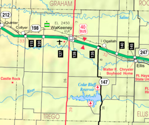
Collyer is a city in Trego County, Kansas, United States. As of the 2020 census, the population of the city was 97. It is located approximately 12 miles west of WaKeeney.

<span class="mw-page-title-main">WaKeeney, Kansas</span> City in Trego County, Kansas, United States

WaKeeney is a city in and the county seat of Trego County, Kansas, United States. As of the 2020 census, the population of the city was 1,799.

References

  1. "Welcome to Trego County Economic Development". Trego County, Kansas. Retrieved November 4, 2012.
  2. 1 2 3 "QuickFacts; Trego County, Kansas; Population, Census, 2020 & 2010". United States Census Bureau. Archived from the original on August 21, 2021. Retrieved August 20, 2021.
  3. "Find a County". National Association of Counties. Retrieved June 7, 2011.
  4. "US Gazetteer files: 2010, 2000, and 1990". United States Census Bureau. February 12, 2011. Retrieved April 23, 2011.
  5. "Annual Estimates of the Resident Population for Counties: April 1, 2020 to July 1, 2023". United States Census Bureau. Retrieved April 3, 2024.
  6. "U.S. Decennial Census". United States Census Bureau. Retrieved July 29, 2014.
  7. "Historical Census Browser". University of Virginia Library. Retrieved July 29, 2014.
  8. "Population of Counties by Decennial Census: 1900 to 1990". United States Census Bureau. Retrieved July 29, 2014.
  9. "Census 2000 PHC-T-4. Ranking Tables for Counties: 1990 and 2000" (PDF). United States Census Bureau. Archived (PDF) from the original on March 27, 2010. Retrieved July 29, 2014.
  10. "U.S. Census website". United States Census Bureau . Retrieved January 31, 2008.
  11. "Dave Leip's Atlas of U.S. Presidential Elections".
  12. "Map of Wet and Dry Counties". Alcoholic Beverage Control, Kansas Department of Revenue. November 2006. Archived from the original on October 8, 2007. Retrieved December 28, 2007.
  13. 1 2 "General Highway Map of Trego County, Kansas" (PDF). Kansas Department of Transportation (KDOT). January 2013. Archived (PDF) from the original on March 31, 2024.
Notes

    Further reading

    County
    Maps

    38°55′N99°53′W / 38.917°N 99.883°W / 38.917; -99.883