Ellis County, Kansas

Last updated

Ellis County
Ellis county courthouse kansas.jpg
Ellis County Courthouse in Hays (1979)
Map of Kansas highlighting Ellis County.svg
Location within the U.S. state of Kansas
Kansas in United States.svg
Kansas's location within the U.S.
Coordinates: 38°55′N99°19′W / 38.917°N 99.317°W / 38.917; -99.317
CountryFlag of the United States.svg United States
StateFlag of Kansas.svg  Kansas
Founded1867
Named for George Ellis [1]
Seat Hays
Largest cityHays
Area
  Total900 sq mi (2,000 km2)
  Land899 sq mi (2,330 km2)
  Water0.5 sq mi (1 km2)  0.05%
Population
 (2020) [2]
  Total28,934
  Density32.2/sq mi (12.4/km2)
Time zone UTC−6 (Central)
  Summer (DST) UTC−5 (CDT)
Area code 785
Congressional district 1st
Website ellisco.net

Ellis County is a county located in the U.S. state of Kansas. Its county seat and most populous city is Hays. [3] As of the 2020 census, the county population was 28,934. [2] The county was named for George Ellis, a first lieutenant of the Twelfth Kansas Infantry. [1] Ellis County is the official German Capital of Kansas. German immigrants settled in Hays, Ellis, Victoria, and nearby villages in the 1870s and 1880s. [4]

Contents

History

19th century

In 1854, the Kansas Territory was organized, then in 1861 Kansas became the 34th U.S. state.

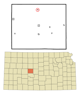
Ellis County was established by an act of the state legislature on 1873-02-16, [1] which defined the original borders of the county as:

Commencing where the east line of range 16 west intersects the second standard parallel, thence south to the third standard parallel, thence west to the east line of range 21 west, thence north to the second standard parallel, thence east to the place of beginning. [1]

The first settlers had been arriving since May 1867, with Fort Fletcher (later Fort Hays) having been built in 1865. [1]

Independent county government was established in October 1867, by proclamation of Governor Samuel J. Crawford in response to a petition. [1] Hays was chosen as the permanent seat by an election in April 1870. [1] Early settlers the Lull brothers, from Salina, had in May 1867 begun a town called Rome just north of the railroad route and on the west of Big Creek, expecting that to become the county seat. [1] It gained a general supply store, Bloomfield, Moses & Co, the following month, and a hotel run by Joseph Perry. [1] However, the Big Creek Land Company platted a competing town named Hays City on the east of Big Creek, which gained the important support of the railroad company. [1] Rome disappeared, with Perry's hotel and several other of its buildings being relocated to Hays City. [1]

Ellis County was named for George Ellis, first lieutenant of the Twelfth Kansas Infantry. [1] [5]

The county's early newspapers were the Star-Sentinel, Hays City Times, and Ellis County Free Press published in Hays City; and the Ellis Head-Light and Ellis Review published in Ellis. [6]

English and Russian-German immigrants

The initial wave of settlement was slow, with three colonies being established in 1872. [7] George Grant, a wealthy Scottish merchant, purchased 70,000 acres (28,000 ha) of land that year, and some 300 farmers from England settled there over the next two years. [7] [8] Grant bought the land from the Kansas Pacific Railroad with the intention of creating a community of British aristocrats and agriculturalists in the middle of rural Kansas. [8] His first town was Victoria named after Queen Victoria where Victoria Manor, a two story stone structure, acted as temporary housing for the immigrants and as a transport depot for the Kansas Pacific. [8] His sales pitch to the immigrants was that it was cheaper to buy land in Kansas at US$11(equivalent to $80.12 in 2023) per acre (Grant himself having purchased it at US$0.88(equivalent to $6.41 in 2023) per acre) than it was to buy land in Britain, and that Grant would till the land and seed it with imported British stock. [8]

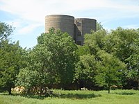
The first wave of young British aristocrat families set sail on 1873-04-01. [8] Stories of the time recorded them as not becoming agriculturalists, as Grant had hoped, but mainly indulging in aristocratic pursuits whilst living off family remittances, including hunting the local wildlife. [8] Another story recounts them placing a dam across Big Creek to make a lake between Victoria and Hays which they then sailed across in a steamboat until the dam was broken by a flood; although at the time of the Ellis county centennial in the 1970s one local resident expressed doubts at the historical veracity of this tale, considering the geography of Big Creek in that area. [8]

However, whilst Grant himself put in great effort to start the colony, including importing Black Angus cattle and running his own cattle farm to the south of Victoria, he died in 1878 and after his death all of the British aristocrats had returned to Britain. [8] A plague of grasshoppers in 1874 drove many away, to be replaced in 1875 by many Russian immigrants. [7] [8]

The Russian immigrants were, more strictly speaking, Volga Germans who had settled in Russia in 1760. [9] The Russification policies begun in 1871 by Alexander II, and especially the 1874-01-13 reversal of the original decree that had exempted them from conscription into the Russian military when they had settled in Russia in the first place, prompted them to look to the United States and elsewhere. [9] [10]

Originally five delegates went on a ten day exploratory mission to Nebraska. [11] Later in December 1874, a four-person delegation went to Topeka and Larned in Kansas, reporting unfavourably on what they found. [11] However, in the meantime the first Germans had been conscripted in November 1874, spurring many to emigrate anyway, [12] which they did arriving in Baltimore on 1875-11-23 and in Topeka on the 28th. [13] Initially deterred from homesteading by the US$5(equivalent to $28.31 in 2023) per acre price of land in North Topeka, they were escorted on three tours of Ellis county by A. Roedelheiner of the Kansas Pacific. [13]

Their initial tour of land around Hog Back almost persuaded the immigrants to return to Russia, but they were shown further land on the Smoky Hill River and near what was to become Catherine and Herzog. [13] This Ellis land was cheaper at US$2.5(equivalent to $71.53 in 2023) per acre, and so on 1876-02-21 fourteen German families came to Hays and from there moved to Liebenthal in Rush County. [14] Three families from Katherinenstadt in Russia also came to Hays on 1876-03-01 and, whilst temporarily renting accommodation therein, built their homes in Catherine to which they moved on 1876-04-08. [14]

Twenty-three families settled in the failing British colony at Victoria on 1876-04-08, settling on the east bank of Victoria Creek just west of where Victoria now exists. [14] Another large wave of immigrants left Russia in June 1876, and some of them arrived in Hays on 1876-07-26 and in Catherine the next day. [14] Others took a different route and arrived and settled in Topeka. [15] Thirteen of the families arrived in Hays on 1876-08-20 and settled in Pfeifer the next day. [15]

One of the largest wave of immigrants was 104 families (originally to be 108, but 4 had been held back because family members had been conscripted, which legally prevented them from emigrating from Russia) in 1876. [15] The Mennonites in the group settled in Nebraska, with the others arrived in Victoria on 1876-08-03 and from there settled in Herzog. [16] The settlers of Munjor stayed in Herzog for two months, before settling on Big Creek just north of the present location of Munjor. [16]

A small wave of immigrants followed the first wave to Pfeifer in late September 1876, with another small wave from Katherinenstadt arriving in Catherine on 1876-09-26. [17] The last 1876 wave of immigrants settled in Munjor. [17]

The German immigrants founded Schoenchen in 1877, some coming directly from Schoenchen in Russia, some coming from Liebenthal in Rush County. [17] Their original plan had been to move from Liebenthal to another site in Rush, but the place that they had chosen was school land that they could not afford, meaning that they could not deed enough of it to the community to erect their church, whilst at the same time land for a church had been deeded in Liebenthal. [17] In recrimination, the Rush county settlers moved to Ellis, joining the direct immigrant party at Schoenchen in April and May 1877. [17] Two other small waves came that year, one to Catherine on 1877-08-06 from Katherinenstadt, [18] and one to Pfiefer from Pfiefer and Kamenka in Russia. [19]

Immigration began to wane in 1878, with a party from Katherinenstadt arriving on 1878-06-20 to settle in Herzog and Pfeifer, and another party from Obermonjour in late July/early August. [19] By this point, property prices had been depressed back in Russia by all of the sales made by the preceding emigrants, and further emigrants were now emigrating at a net loss. [19] Another party, having had to cover the Russian emigration fees through deceit, claiming that two of their number had died to officials who only dealt with the two people who left the train, since the party collectively had not enough money for all even though they had pooled their funds, arrived in Herzog and Munjor and was the last large wave of Volga German immigrants to Ellis. [19] [20]

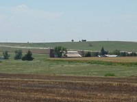
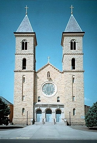
By 1903, there had been 222 immigrants to Catherine, some going thence elsewhere. [20] Munjor grew from 130 families, 794 people, in 1897 to 156 families, 931 people, by 1900. [20] The largest of the Volga German settlements was Herzog, having roughly 1700 people (measured from church congregation size as accounted in the Victoria Chronicle) in 1895, with Pfeifer and Schoenchen coming fourth and fifth. [20]

20th century

In 1942, the Walker Army Airfield was built northwest of Walker. Thousands were stationed at the airfield for training of the Boeing B-29 Superfortress during World War II. The airfield was abandoned and most of it razed.

Geography

According to the U.S. Census Bureau, the county has a total area of 900 square miles (2,300 km2), of which 900 square miles (2,300 km2) is land and 0.5 square miles (1.3 km2) (0.05%) is water. [21]

Geology and hydrology

The county is crossed by the Saline River across the north, with its principal branch being Eagle Creek. [22] [1] Other rivers include Big Creek, with its principal tributary Victoria Creek, which is in turn a tributary of the Smoky Hill River which flows across the south. [22] [1] The county had several salt marshes in 1886. [22] [1]

The river banks had a lot of limestone, and around Hays City in the 19th century there was a lot of clay. [1]

Adjacent counties

Major highways

Airport

Hays Regional Airport is located within the county. Used primarily for general aviation, it hosts one commercial airline United Express, which offers daily jet service to Denver, Colorado.

Demographics

Population pyramid based on 2000 census age data USA Ellis County, Kansas age pyramid.svg
Population pyramid based on 2000 census age data
Historical population
CensusPop.Note
1870 1,336
1880 6,179362.5%
1890 7,94228.5%
1900 8,6268.6%
1910 12,17041.1%
1920 14,13816.2%
1930 15,90712.5%
1940 17,50810.1%
1950 19,0438.8%
1960 21,27011.7%
1970 24,73016.3%
1980 26,0985.5%
1990 26,004−0.4%
2000 27,5075.8%
2010 28,4523.4%
2020 28,9341.7%
2023 (est.)28,810 [23] −0.4%
U.S. Decennial Census [24]
1790-1960 [25] 1900-1990 [26]
1990-2000 [27] 2010-2020 [2]

The Hays Micropolitan Statistical Area includes all of Ellis County.

In 1886, the population was 5.842, having risen from 5,046 in 1885. [28] In 1910, the population was 12,170. [7]

As of 2000, [29] there were 27,507 people, 11,193 households, and 6,771 families residing in the county. The population density was 31 people per square mile (12 people/km2). There were 12,078 housing units at an average density of 13 per square mile (5.0/km2). The racial makeup of the county was 96.10% White, 0.67% Black or African American, 0.21% Native American, 0.82% Asian, 0.02% Pacific Islander, 1.31% from other races, and 0.89% from two or more races. Hispanic or Latino of any race were 2.37% of the population.

There were 11,193 households, out of which 28.80% had children under the age of 18 living with them, 50.00% were married couples living together, 7.80% had a female householder with no husband present, and 39.50% were non-families. 30.10% of all households were made up of individuals, and 10.80% had someone living alone who was 65 years of age or older. The average household size was 2.35 and the average family size was 2.96.

In the county, the population was spread out, with 22.40% under the age of 18, 18.40% from 18 to 24, 25.20% from 25 to 44, 19.60% from 45 to 64, and 14.30% who were 65 years of age or older. The median age was 33 years. For every 100 females there were 95.80 males. For every 100 females age 18 and over, there were 92.60 males.

The median income for a household in the county was $32,339, and the median income for a family was $44,498. Males had a median income of $29,885 versus $21,269 for females. The per capita income for the county was $18,259. About 6.50% of families and 12.90% of the population were below the poverty line, including 9.20% of those under age 18 and 10.00% of those age 65 or over.

Government

Presidential elections

Presidential election results
United States presidential election results for Ellis County, Kansas [30]
Year Republican Democratic Third party
No.%No.%No.%
2020 9,75870.42%3,73726.97%3612.61%
2016 8,46670.19%2,74222.73%8547.08%
2012 8,39971.70%3,05726.10%2582.20%
2008 8,20765.94%4,01032.22%2301.85%
2004 7,89164.75%4,03333.09%2632.16%
2000 6,51658.39%3,92635.18%7186.43%
1996 6,80956.97%4,14234.66%1,0018.38%
1992 3,98532.00%4,54436.49%3,92431.51%
1988 5,19448.67%5,28949.56%1891.77%
1984 7,50967.65%3,45731.15%1331.20%
1980 5,63452.54%3,94036.74%1,15010.72%
1976 4,71941.98%6,28055.87%2412.14%
1972 5,46355.67%4,11341.91%2372.42%
1968 3,94446.72%3,80945.12%6888.15%
1964 2,44030.42%5,55369.24%270.34%
1960 3,15635.16%5,81564.78%60.07%
1956 4,46659.33%3,05840.62%40.05%
1952 4,88265.86%2,52834.10%30.04%
1948 2,67640.51%3,86358.48%671.01%
1944 3,36960.13%2,21839.59%160.29%
1940 3,62252.15%3,29947.49%250.36%
1936 1,62225.07%4,83474.73%130.20%
1932 1,46524.54%4,44974.52%560.94%
1928 1,70033.50%3,36466.29%110.22%
1924 1,76346.37%84222.15%1,19731.48%
1920 2,38575.17%74023.32%481.51%
1916 1,18632.87%2,33564.72%872.41%
1912 1758.22%1,38164.87%57326.91%
1908 76834.50%1,42163.84%371.66%
1904 1,00951.06%92846.96%391.97%
1900 62733.55%1,22865.70%140.75%
1896 46030.01%1,05168.56%221.44%
1892 54633.52%00.00%1,08366.48%
1888 69044.43%75648.68%1076.89%

Ellis County is an anomaly in western Kansas, having voted several times for Democratic presidential candidates, even when the vast majority of the state's 105 counties went for the Republican nominee. This is due to the county's distinctive (in Kansas) German Catholic heritage, contrasting with the Southern “Bible Belt” or Yankee heritage of most rural Kansas counties. It was the solitary county in Kansas to support Catholic Al Smith over Herbert Hoover in 1928, when Kansas was Hoover's strongest state nationwide, and also was won by John F. Kennedy in 1960 by almost thirty percent as one of only two Kansas counties to back the Massachusetts Senator. Ellis County bucked the national and statewide trend by voting for Michael Dukakis over winner George H. W. Bush in the 1988 presidential election, one of only three Kansas counties to go for Dukakis. Ellis County gave a plurality to Bill Clinton over Bush and Ross Perot in the 1992 presidential election, but has been solidly in the Republican column since, giving 66 percent to Republican John McCain to 32 percent for Democrat Barack Obama in the 2008 election, higher than the 57 percent McCain won statewide. [31]

Laws

Wild Bill Hickok served as sheriff in 1870. Ellis County was a prohibition, or "dry", county until the Kansas Constitution was amended in 1986 and voters approved the sale of alcoholic liquor by the individual drink with a 30% food sales requirement. The food sales requirement was removed with voter approval in 1988. [32]

Education

Unified school districts

There were 44 school districts by 1886. [33]

Private schools

Universities and Colleges

Communities

2005 map of Ellis County (map legend) Map of Ellis Co, Ks, USA.png
2005 map of Ellis County (map legend)

Many settlements in Ellis are named after the original settlements in Russia from which the Volga Germans immigrated, [9] including Catherine from Katherinenstatd (a.k.a. Baronsk and founded in 1765 by Baron de Beauregard), Shoenchen (a.k.a. Paninskoje and founded in 1767), Pfeifer (a.k.a. Gniluska and founded in 1766), Herzog (founded in 1764), and Munjor from Obermonjour (founded 1766) and Neo-Obermonjour (founded 1859). [35] In 1886, there were twelve post offices in the county: Catharine, Easdale, Ellis, Hays City, Martin, Mendota, Munjor, Palatine, Stockrange, Turkville, Victoria, and Walker. [6]

List of townships / incorporated cities / unincorporated communities / extinct former communities within Ellis County. [34]

Cities

Unincorporated communities

† means a community is designated a Census-Designated Place (CDP) by the United States Census Bureau.

Ghost towns

In the 19th and early 20th century there were various communities that no longer exist today:

Townships

Ellis County is divided into nine townships. The cities of Ellis and Hays are considered governmentally independent and are excluded from the census figures for the townships. In the following table, the population center is the largest city (or cities) included in that township's population total, if it is of a significant size.

Township FIPS Population
center
PopulationPopulation
density
/km2 (/sq mi)
Land area
km2 (sq mi)
Water area
km2 (sq mi)
Water %Geographic coordinates
Big Creek066501,7987 (18)252 (97)0 (0)0.01% 38°52′40″N99°20′39″W / 38.87778°N 99.34417°W / 38.87778; -99.34417
Buckeye089502851 (2)352 (136)0 (0)0.06% 39°1′24″N99°18′25″W / 39.02333°N 99.30694°W / 39.02333; -99.30694
Catherine110503182 (4)208 (80)0 (0)0.03% 39°0′32″N99°11′44″W / 39.00889°N 99.19556°W / 39.00889; -99.19556
Ellis204753861 (2)457 (176)0 (0)0.02% 38°58′47″N99°30′57″W / 38.97972°N 99.51583°W / 38.97972; -99.51583
Freedom246251251 (3)117 (45)0 (0)0% 38°43′48″N99°7′36″W / 38.73000°N 99.12667°W / 38.73000; -99.12667
Herzog315258943 (7)325 (126)1 (0)0.18% 38°55′29″N99°7′19″W / 38.92472°N 99.12194°W / 38.92472; -99.12194
Lookout427005692 (5)317 (122)0 (0)0.10% 38°45′43″N99°25′12″W / 38.76194°N 99.42000°W / 38.76194; -99.42000
Victoria738008456 (16)139 (54)0 (0)0% 38°49′56″N99°8′31″W / 38.83222°N 99.14194°W / 38.83222; -99.14194
Wheatland776504013 (7)140 (54)0 (0)0% 38°46′45″N99°16′19″W / 38.77917°N 99.27194°W / 38.77917; -99.27194
Sources: "Census 2000 U.S. Gazetteer Files". U.S. Census Bureau, Geography Division. Archived from the original on August 2, 2002.

At the start of the 20th century, the townships were: Big Creek, Buckeye, Catherine, Ellis, Freedom, Hamilton, Herzog, Lookout, Pleasant Hill, Saline, Smoky Hill, Victoria, Walker, and Wheatlan. [39]

See also

Community information for Kansas

Related Research Articles

<span class="mw-page-title-main">Decatur County, Kansas</span> County in Kansas, United States

Decatur County is a county located in Northwest Kansas. Its county seat and most populous city is Oberlin. As of the 2020 census, the county population was 2,764. The county was named in honor of Stephen Decatur, Jr., a commodore in the United States Navy who served during both Barbary Wars in North Africa, the Quasi-War with France, and the War of 1812 with Britain.

<span class="mw-page-title-main">Cheyenne County, Kansas</span> County in Kansas, United States

Cheyenne County is a county located in the northwest corner of the U.S. state of Kansas. Its county seat and most populous city is St. Francis. As of the 2020 census, the county population was 2,616. The county was named after the Cheyenne tribe.

<span class="mw-page-title-main">Hays, Kansas</span> City in Ellis County, Kansas

Hays is a city in and the county seat of Ellis County, Kansas, United States. The largest city in northwestern Kansas, it is the economic and cultural center of the region. As of the 2020 census, the population of the city was 21,116. It is also a college town, home to Fort Hays State University.

<span class="mw-page-title-main">Schoenchen, Kansas</span> City in Ellis County, Kansas

Schoenchen is a city in Ellis County, Kansas, United States. As of the 2020 census, the population of the city was 170.

<span class="mw-page-title-main">Victoria, Kansas</span> City in Ellis County, Kansas

Victoria is a city in Herzog Township, Ellis County, Kansas, United States. As of the 2020 census, the population of the city was 1,129.

<span class="mw-page-title-main">Liebenthal, Kansas</span> City in Rush County, Kansas

Liebenthal is a city in Rush County, Kansas, United States. As of the 2020 census, the population of the city was 92. It is located 8 miles north of La Crosse.

Russian Germans in North America are descended from the many ethnic Germans from Russia who emigrated to North America.

Herzog is a German title of nobility.

<span class="mw-page-title-main">Diamond Creek Township, Chase County, Kansas</span> Township in Kansas, United States

Diamond Creek Township is a township in Chase County, Kansas, United States. As of the 2000 census, its population was 237.

<span class="mw-page-title-main">Freedom Township, Ellis County, Kansas</span> Township in Kansas, United States

Freedom Township is a township in Ellis County, Kansas, United States. As of the 2010 census, its population was 118.

<span class="mw-page-title-main">Victoria Township, Ellis County, Kansas</span> Township in Kansas, United States

Victoria Township was a township in Ellis County, Kansas, United States. As of the 2010 census, its population was 876. Since then, it was merged into the enlarged Herzog Township.

<span class="mw-page-title-main">Catharine, Kansas</span> Unincorporated community in Ellis County, Kansas

Catharine is an unincorporated community in Catherine Township, Ellis County, Kansas, United States. As of the 2020 census, the population of the community and nearby areas was 113.

<span class="mw-page-title-main">Pfeifer, Kansas</span> Unincorporated community in Ellis County, Kansas

Pfeifer is an unincorporated community in Freedom Township, Ellis County, Kansas, United States. It is located 10 miles (16 km) south of Victoria.

<span class="mw-page-title-main">Walker, Kansas</span> Unincorporated community in Ellis County, Kansas

Walker is an unincorporated community in Herzog Township, Ellis County, Kansas, United States. It is located between Hays and Russell, along old Hwy 40 on the north side of I-70. Walker has a post office with ZIP code 67674.

<span class="mw-page-title-main">Emmeram, Kansas</span> Unincorporated community in Ellis County, Kansas

Emmeram is an unincorporated community in Herzog Township, Ellis County, Kansas, United States.

<span class="mw-page-title-main">Munjor, Kansas</span> Unincorporated community in Ellis County, Kansas, United States

Munjor is an unincorporated community in Wheatland Township, Ellis County, Kansas, United States. As of the 2020 census, the population of the community and nearby areas was 232.

<span class="mw-page-title-main">Yocemento, Kansas</span> Unincorporated community in Ellis County, Kansas

Yocemento is an unincorporated community in Big Creek Township, Ellis County, Kansas, United States. The settlement lies across the banks of Big Creek against the base of bluffs capped by massive limestone blocks, in which lies the 20th-century origin of the community.

<span class="mw-page-title-main">Turkville, Kansas</span> Ghost town in Ellis County, Kansas

Turkville is a ghost town in Buckeye Township, Ellis County, Kansas, United States.

<span class="mw-page-title-main">Fort Hays Limestone Member</span>

The Fort Hays Limestone is a member of the Niobrara Formation of the Colorado Group exposed in Colorado, Kansas, Nebraska, and South Dakota and is named for the bluffs near the old Fort Hays, a well-known landmark in western Kansas.

<span class="mw-page-title-main">Fencepost limestone</span>

Fencepost limestone, Post Rock limestone, or Stone Post is a stone bed in the Great Plains notable for its historic use as fencing and construction material in north-central Kansas resulting in unique cultural expression. The source of this stone is the topmost layer of the Greenhorn Limestone formation. It is a regional marker bed as well as a valued construction material of the late 19th and early 20th centuries in Kansas. This stone was very suitable for early construction in treeless settlements and it adds a notable rust orange tint to the region's many historic stone buildings. But the most famous use is seen in the countless miles of stone posts lining country roads and highways. This status gives rise to such regional appellations as Stone Post Country, Post Rock Scenic Byway, and The Post Rock Capital of Kansas. This rustic quality finds Fencepost limestone still used in Kansas landscaping today.

References

  1. 1 2 3 4 5 6 7 8 9 10 11 12 13 14 15 16 17 Blackmar 1912a, p. 578.
  2. 1 2 3 "QuickFacts; Ellis County, Kansas; Population, Census, 2020 & 2010". United States Census Bureau. Archived from the original on August 16, 2021. Retrieved August 16, 2021.
  3. "Find a County". National Association of Counties. Archived from the original on May 31, 2011. Retrieved June 7, 2011.
  4. "Tidbits: Did You Know...". Publishing Group of America (americanprofiles.com). p. 13.
  5. Gannett, Henry (1905). The Origin of Certain Place Names in the United States. Govt. Print. Off. pp.  117.
  6. 1 2 Sims & Wheeler 1887, p. 212.
  7. 1 2 3 4 Blackmar 1912a, p. 579.
  8. 1 2 3 4 5 6 7 8 9 Muilenburg & Swineford 1975, p. 21.
  9. 1 2 3 Muilenburg & Swineford 1975, p. 22.
  10. Laing 1910, p. 3.
  11. 1 2 Laing 1910, p. 4.
  12. Laing 1910, p. 5.
  13. 1 2 3 Laing 1910, p. 6.
  14. 1 2 3 4 Laing 1910, p. 7.
  15. 1 2 3 Laing 1910, p. 8.
  16. 1 2 Laing 1910, p. 9.
  17. 1 2 3 4 5 Laing 1910, p. 10.
  18. Laing 1910, p. 11.
  19. 1 2 3 4 Laing 1910, p. 12.
  20. 1 2 3 4 Laing 1910, p. 14.
  21. "US Gazetteer files: 2010, 2000, and 1990". United States Census Bureau. February 12, 2011. Retrieved April 23, 2011.
  22. 1 2 3 Sims & Wheeler 1887, p. 209.
  23. "Annual Estimates of the Resident Population for Counties: April 1, 2020 to July 1, 2023". United States Census Bureau. Retrieved April 3, 2024.
  24. "U.S. Decennial Census". United States Census Bureau. Retrieved July 24, 2014.
  25. "Historical Census Browser". University of Virginia Library. Retrieved July 24, 2014.
  26. "Population of Counties by Decennial Census: 1900 to 1990". United States Census Bureau. Retrieved July 24, 2014.
  27. "Census 2000 PHC-T-4. Ranking Tables for Counties: 1990 and 2000" (PDF). United States Census Bureau. Archived (PDF) from the original on March 27, 2010. Retrieved July 24, 2014.
  28. Sims & Wheeler 1887, p. 208.
  29. "U.S. Census website". United States Census Bureau . Retrieved January 31, 2008.
  30. "Dave Leip's Atlas of U.S. Presidential Elections".
  31. 2008 Presidential General Election Results - Kansas
  32. "Map of Wet and Dry Counties". Alcoholic Beverage Control, Kansas Department of Revenue. November 2006. Archived from the original on October 8, 2007. Retrieved December 28, 2007.
  33. Sims & Wheeler 1887, p. 211.
  34. 1 2 "General Highway Map of Ellis County, Kansas" (PDF). Kansas Department of Transportation (KDOT). June 2010. Archived (PDF) from the original on April 8, 2023.
  35. Laing 1910, p. 2.
  36. Blackmar 1912b, p. 268.
  37. Blackmar 1912b, p. 372.
  38. Blackmar 1912b, p. 708.
  39. Blackmar 1912a, pp. 579–580.

Sources

Further reading

County
Maps